
Mount Umunhum
Encyclopedia
Mount Umunhum
is the fourth-highest peak in the Santa Cruz Mountains
of California
(after Loma Prieta
, Crystal Peak, and Mt. Chual). The mountain is situated in Santa Clara County
, southeast of Los Gatos
and south of South San Jose
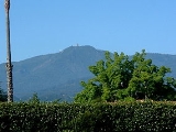
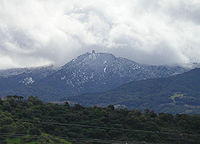
. The peak can be recognized in the South Bay Area by the five-story concrete radar tower building that sits atop the summit.
 The summit of Mount Umunhum is the site of the former Almaden Air Force Station
, an early-warning radar
station that operated from 1958 to 1980. Most of the mountain is within the Sierra Azul Open Space Preserve
, managed by the Midpeninsula Regional Open Space District
(MROSD).
The summit is closed to the public due to lead
, black mold, and asbestos
contamination of the former Air Force
station. Plans are underway to clean up and restore the summit for public use, with demolition of the landmark tower being considered.
The mountain is also the site of the Bay Area NEXRAD
weather radar
.
The high elevation is necessary for line of sight in the region's varied terrain, but it also limits the ability to detect storms with bases lower in the atmosphere.
Sometimes referred to as "Mount Um" by locals, the mountain is a well-known landmark in the bay area.
is the fourth-highest peak in the Santa Cruz Mountains
Santa Cruz Mountains
The Santa Cruz Mountains, part of the Pacific Coast Ranges, are a mountain range in central California, United States. They form a ridge along the San Francisco Peninsula, south of San Francisco, separating the Pacific Ocean from San Francisco Bay and the Santa Clara Valley, and continuing south,...
of California
California
California is a state located on the West Coast of the United States. It is by far the most populous U.S. state, and the third-largest by land area...
(after Loma Prieta
Loma Prieta
Loma Prieta is a Northern California mountain located in the Santa Cruz Mountains. The peak is located on private property, about west of Morgan Hill and within the boundaries of Santa Clara County...
, Crystal Peak, and Mt. Chual). The mountain is situated in Santa Clara County
Santa Clara County, California
Santa Clara County is a county located at the southern end of the San Francisco Bay Area in the U.S. state of California. As of 2010 it had a population of 1,781,642. The county seat is San Jose. The highly urbanized Santa Clara Valley within Santa Clara County is also known as Silicon Valley...
, southeast of Los Gatos
Los Gatos, California
The Town of Los Gatos is an incorporated town in Santa Clara County, California, United States. The population was 29,413 at the 2010 census. It is located in the San Francisco Bay Area at the southwest corner of San Jose in the foothills of the Santa Cruz Mountains...
and south of South San Jose
San Jose, California
San Jose is the third-largest city in California, the tenth-largest in the U.S., and the county seat of Santa Clara County which is located at the southern end of San Francisco Bay...
. The peak can be recognized in the South Bay Area by the five-story concrete radar tower building that sits atop the summit.
Almaden Air Force Station
Almaden Air Force Station is a closed United States Air Force General Surveillance Radar station. It is located southeast of Los Gatos, California...
, an early-warning radar
Radar
Radar is an object-detection system which uses radio waves to determine the range, altitude, direction, or speed of objects. It can be used to detect aircraft, ships, spacecraft, guided missiles, motor vehicles, weather formations, and terrain. The radar dish or antenna transmits pulses of radio...
station that operated from 1958 to 1980. Most of the mountain is within the Sierra Azul Open Space Preserve
Sierra Azul Open Space Preserve
Sierra Azul Open Space Preserve is managed by the Midpeninsula Regional Open Space District in Santa Clara County, California. It's approximately in area. The park features the Sierra Azul range's peaks of Mount Umunhum, Mount Thayer, and El Sombroso...
, managed by the Midpeninsula Regional Open Space District
Midpeninsula Regional Open Space District
The Midpeninsula Regional Open Space District is a special-purpose district that manages over of open space in 25 preserves in the San Francisco Bay Area. It includes parts of Santa Clara, San Mateo and Santa Cruz Counties. The District was created by voter initiative in 1972...
(MROSD).
The summit is closed to the public due to lead
Lead
Lead is a main-group element in the carbon group with the symbol Pb and atomic number 82. Lead is a soft, malleable poor metal. It is also counted as one of the heavy metals. Metallic lead has a bluish-white color after being freshly cut, but it soon tarnishes to a dull grayish color when exposed...
, black mold, and asbestos
Asbestos
Asbestos is a set of six naturally occurring silicate minerals used commercially for their desirable physical properties. They all have in common their eponymous, asbestiform habit: long, thin fibrous crystals...
contamination of the former Air Force
United States Air Force
The United States Air Force is the aerial warfare service branch of the United States Armed Forces and one of the American uniformed services. Initially part of the United States Army, the USAF was formed as a separate branch of the military on September 18, 1947 under the National Security Act of...
station. Plans are underway to clean up and restore the summit for public use, with demolition of the landmark tower being considered.
The mountain is also the site of the Bay Area NEXRAD
NEXRAD
NEXRAD or Nexrad is a network of 159 high-resolution Doppler weather radars operated by the National Weather Service, an agency of the National Oceanic and Atmospheric Administration within the United States Department of Commerce...
weather radar
Weather radar
Weather radar, also called weather surveillance radar and Doppler weather radar, is a type of radar used to locate precipitation, calculate its motion, estimate its type . Modern weather radars are mostly pulse-Doppler radars, capable of detecting the motion of rain droplets in addition to the...
.
The high elevation is necessary for line of sight in the region's varied terrain, but it also limits the ability to detect storms with bases lower in the atmosphere.
Sometimes referred to as "Mount Um" by locals, the mountain is a well-known landmark in the bay area.