
.gif)
Sierra Madre Mountains (California)
Encyclopedia
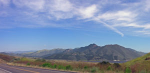
The Sierra Madre Mountains are a mountain range
in northern Santa Barbara County, California
, USA
. They are a portion of the Inner South Coast Ranges, representing the southernmost part, which are themselves part of the Pacific Coast Ranges
of western North America
. The Sierra Madre Mountains trend from northwest to southeast, and are approximately 25 mi (40.2 km) long. High peaks in the range include MacPherson Peak (5747 feet (1,752 m)), and the highest point in the range, Peak Mountain (5843 feet (1,781 m)). To the southeast, the range merges with the San Rafael Mountains
in a complex topography of unnamed ranges, the highest point of which is Big Pine Mountain
(6820 ft (2,079 m)), the highest point in Santa Barbara County. Snow falls on the highest peaks during the winter months.
The Sierra Madre Mountains are almost entirely within the Los Padres National Forest
, and mark the northern boundary of the San Rafael Wilderness
. The southeastern extent of the range is about 25 mi (40.2 km) north of the city of Santa Barbara
, and the northwestern extent of the range is about 50 mi (80.5 km) north by northwest of the city.
 The predominant vegetation type on the mountains is chaparral
; however oak woodlands occur in some areas, and some of the higher slopes support small areas of coniferous forest. The mountains are one of the most important habitat areas of the endangered California Condor
.
Geologically, the mountains are almost entirely composed of sedimentary rock
s of Tertiary
age. Most of the rocks are Eocene
marine sandstone
s and other sediments, and one region in the eastern portion of the range is made up of middle and early Miocene
sediments. The mountain range is delineated on the south by the Nacimiento Fault, and on the north, by the South Cuyama and Ozena Faults. The Sierra Madre Mountains rise abruptly just south of the Cuyama Valley
, which defines the northern boundary of Santa Barbara County.
The mountain range is almost entirely uninhabited, except for portions of the lower slopes to the north, which is developed for oil and gas production at the South Cuyama Oil Field
. One difficult, single-lane dirt road follows the mountain crest; it often is closed after storms, and is normally only passable by four-wheel-drive vehicles or motorcycles.
Mountain range
A mountain range is a single, large mass consisting of a succession of mountains or narrowly spaced mountain ridges, with or without peaks, closely related in position, direction, formation, and age; a component part of a mountain system or of a mountain chain...
in northern Santa Barbara County, California
California
California is a state located on the West Coast of the United States. It is by far the most populous U.S. state, and the third-largest by land area...
, USA
United States
The United States of America is a federal constitutional republic comprising fifty states and a federal district...
. They are a portion of the Inner South Coast Ranges, representing the southernmost part, which are themselves part of the Pacific Coast Ranges
Pacific Coast Ranges
The Pacific Coast Ranges and the Pacific Mountain System are the series of mountain ranges that stretch along the West Coast of North America from Alaska south to Northern and Central Mexico...
of western North America
North America
North America is a continent wholly within the Northern Hemisphere and almost wholly within the Western Hemisphere. It is also considered a northern subcontinent of the Americas...
. The Sierra Madre Mountains trend from northwest to southeast, and are approximately 25 mi (40.2 km) long. High peaks in the range include MacPherson Peak (5747 feet (1,752 m)), and the highest point in the range, Peak Mountain (5843 feet (1,781 m)). To the southeast, the range merges with the San Rafael Mountains
San Rafael Mountains
The San Rafael Mountains are a mountain range in central Santa Barbara County, California, U.S.. They are part of the Transverse Ranges system of Southern California which in turn are part of the Pacific Coast Ranges system of western North America....
in a complex topography of unnamed ranges, the highest point of which is Big Pine Mountain
Big Pine Mountain
Big Pine Mountain is a mountain located in the San Rafael Mountains of the Transverse Ranges in California. High enough to receive snowfall during the winter,...
(6820 ft (2,079 m)), the highest point in Santa Barbara County. Snow falls on the highest peaks during the winter months.
The Sierra Madre Mountains are almost entirely within the Los Padres National Forest
Los Padres National Forest
Los Padres National Forest is a forest located in southern and central California, which includes most of the mountainous land along the California coast from Ventura to Monterey, extending inland...
, and mark the northern boundary of the San Rafael Wilderness
San Rafael Wilderness
The San Rafael Wilderness is a wilderness area in the mountains of north central Santa Barbara County, California, USA. It is completely contained within the Los Padres National Forest, and is north of the city of Santa Barbara and east of Santa Maria...
. The southeastern extent of the range is about 25 mi (40.2 km) north of the city of Santa Barbara
Santa Barbara, California
Santa Barbara is the county seat of Santa Barbara County, California, United States. Situated on an east-west trending section of coastline, the longest such section on the West Coast of the United States, the city lies between the steeply-rising Santa Ynez Mountains and the Pacific Ocean...
, and the northwestern extent of the range is about 50 mi (80.5 km) north by northwest of the city.
Chaparral
Chaparral is a shrubland or heathland plant community found primarily in the U.S. state of California and in the northern portion of the Baja California peninsula, Mexico...
; however oak woodlands occur in some areas, and some of the higher slopes support small areas of coniferous forest. The mountains are one of the most important habitat areas of the endangered California Condor
California Condor
The California Condor is a New World vulture, the largest North American land bird. Currently, this condor inhabits only the Grand Canyon area, Zion National Park, and coastal mountains of central and southern California and northern Baja California...
.
Geologically, the mountains are almost entirely composed of sedimentary rock
Sedimentary rock
Sedimentary rock are types of rock that are formed by the deposition of material at the Earth's surface and within bodies of water. Sedimentation is the collective name for processes that cause mineral and/or organic particles to settle and accumulate or minerals to precipitate from a solution....
s of Tertiary
Tertiary
The Tertiary is a deprecated term for a geologic period 65 million to 2.6 million years ago. The Tertiary covered the time span between the superseded Secondary period and the Quaternary...
age. Most of the rocks are Eocene
Eocene
The Eocene Epoch, lasting from about 56 to 34 million years ago , is a major division of the geologic timescale and the second epoch of the Paleogene Period in the Cenozoic Era. The Eocene spans the time from the end of the Palaeocene Epoch to the beginning of the Oligocene Epoch. The start of the...
marine sandstone
Sandstone
Sandstone is a sedimentary rock composed mainly of sand-sized minerals or rock grains.Most sandstone is composed of quartz and/or feldspar because these are the most common minerals in the Earth's crust. Like sand, sandstone may be any colour, but the most common colours are tan, brown, yellow,...
s and other sediments, and one region in the eastern portion of the range is made up of middle and early Miocene
Miocene
The Miocene is a geological epoch of the Neogene Period and extends from about . The Miocene was named by Sir Charles Lyell. Its name comes from the Greek words and and means "less recent" because it has 18% fewer modern sea invertebrates than the Pliocene. The Miocene follows the Oligocene...
sediments. The mountain range is delineated on the south by the Nacimiento Fault, and on the north, by the South Cuyama and Ozena Faults. The Sierra Madre Mountains rise abruptly just south of the Cuyama Valley
Cuyama Valley
The Cuyama Valley is a valley along the Cuyama River in central California, in northern Santa Barbara, southern San Luis Obispo, southwestern Kern, and northwestern Ventura counties. It is a sparsely inhabited area containing two significant towns – Cuyama and New Cuyama – and is largely used for...
, which defines the northern boundary of Santa Barbara County.
The mountain range is almost entirely uninhabited, except for portions of the lower slopes to the north, which is developed for oil and gas production at the South Cuyama Oil Field
South Cuyama Oil Field
The South Cuyama Oil Field is a large oil and gas field in the Cuyama Valley and the adjacent northern foothills of the Sierra Madre Mountains in northeastern Santa Barbara County, California...
. One difficult, single-lane dirt road follows the mountain crest; it often is closed after storms, and is normally only passable by four-wheel-drive vehicles or motorcycles.