
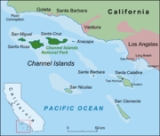
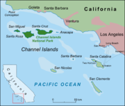
San Miguel Island
Encyclopedia
Santa Barbara Channel
The Santa Barbara Channel is a portion of the Pacific Ocean which separates the mainland of California from the northern Channel Islands. It is generally south of the city of Santa Barbara, and west of the city of Ventura....
in the Pacific Ocean
Pacific Ocean
The Pacific Ocean is the largest of the Earth's oceanic divisions. It extends from the Arctic in the north to the Southern Ocean in the south, bounded by Asia and Australia in the west, and the Americas in the east.At 165.2 million square kilometres in area, this largest division of the World...
, within Santa Barbara County
Santa Barbara County, California
Santa Barbara County is a county located in the southern portion of the U.S. state of California, on the Pacific coast. As of 2010 the county had a population of 423,895. The county seat is Santa Barbara and the largest city is Santa Maria.-History:...
, California
California
California is a state located on the West Coast of the United States. It is by far the most populous U.S. state, and the third-largest by land area...
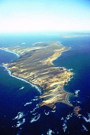
. San Miguel is the sixth-largest of the eight Channel Islands at 9325 acres (37.74 km²), including offshore islands and rocks. Prince Island, 700 m (2,296.6 ft) off the northeastern coast, measures 35 acre (14.2 ha) in area. The island, at its farthest extent, is 8 miles (12.9 km) long and 3.7 miles (6 km) wide.
San Miguel Island is part of Channel Islands National Park
Channel Islands National Park
- External links :* Official site: * *...
, and almost all of the island (8960 acres (36.3 km²)) has also been designated as an archeological district on the National Register of Historic Places
National Register of Historic Places
The National Register of Historic Places is the United States government's official list of districts, sites, buildings, structures, and objects deemed worthy of preservation...
. This westernmost Channel Island receives northwesterly winds and severe weather from the open ocean. The cold and nutrient-rich water surrounding the island is home to a diverse array of sea life that is not found on the southern islands.
San Miguel Island, together with numerous small islets around it, is defined by the United States Census Bureau
United States Census Bureau
The United States Census Bureau is the government agency that is responsible for the United States Census. It also gathers other national demographic and economic data...
as Block 3010, Block Group 3, Census Tract
Census tract
A census tract, census area, or census district is a geographic region defined for the purpose of taking a census. Usually these coincide with the limits of cities, towns or other administrative areas and several tracts commonly exist within a county...
29.10 of Santa Barbara County, California
Santa Barbara County, California
Santa Barbara County is a county located in the southern portion of the U.S. state of California, on the Pacific coast. As of 2010 the county had a population of 423,895. The county seat is Santa Barbara and the largest city is Santa Maria.-History:...
. The island is uninhabited. Highest peak is San Miguel Hill, at 831 feet (253.3 m). Submerged rocks make the nearly 28 miles (45.1 km) coastline a mariner's nightmare.
History
Archaeological research has shown that San Miguel Island was first settled by humans at least 12,000 years ago, in the Millingstone HorizonMillingstone Horizon
Millingstone Horizon is an archaeological period of Native American dominance denoting a period in California, USA involving extensive use of manos and other grinding technology. The interval is a subset of the Archaic Period; specifically Millingstone is usually applied to the period 6500 to...
archaeological period. Because the northern Channel Islands have not been connected to the adjacent mainland in recent geological history, the Paleo-Indians who first settled the island clearly had boats and other maritime technologies. Rough seas and risky landings did not daunt the Chumash people who used Tomol
Tomol
Tomols are plank-built boats, historically and currently used by the Chumash and Tongva Native Americans in the Santa Barbara and Los Angeles area. They were also called tii'at by the Tongva. Tomols are long. They were especially important as both tribes relied on the sea for...
s to reach their settlements, there for centuries.
The first Europe
Europe
Europe is, by convention, one of the world's seven continents. Comprising the westernmost peninsula of Eurasia, Europe is generally 'divided' from Asia to its east by the watershed divides of the Ural and Caucasus Mountains, the Ural River, the Caspian and Black Seas, and the waterways connecting...
an explorer to land was the Spanish-Portuguese explorer Juan Rodriguez Cabrillo
Juan Rodríguez Cabrillo
Juan Rodriguez Cabrillo was a Portuguese explorer noted for his exploration of the west coast of North America on behalf of Spain. Cabrillo was the first European explorer to navigate the coast of present day California in the United States...
in 1542, who died on the island and is buried there. Ranchers raised sheep here from 1850 to 1948. One of the longest homesteaded Ranchers were the Lesters, a family of four that parted their way from the island during Pearl Harbor due to the dangers the war posed on them. The detailed information was written and published in a book called "The Legendary King of San Miguel Island," by Elizabeth Sherman Lester.
Later, the United States Navy
United States Navy
The United States Navy is the naval warfare service branch of the United States Armed Forces and one of the seven uniformed services of the United States. The U.S. Navy is the largest in the world; its battle fleet tonnage is greater than that of the next 13 largest navies combined. The U.S...
used the island for a bombing range.
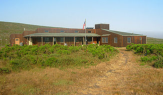
Park Service operations
Pinniped
Pinnipeds or fin-footed mammals are a widely distributed and diverse group of semiaquatic marine mammals comprising the families Odobenidae , Otariidae , and Phocidae .-Overview: Pinnipeds are typically sleek-bodied and barrel-shaped...
s and manage the Island Fox
Island Fox
The island fox is a small fox that is native to six of the eight Channel Islands of California. There are six subspecies of the fox, each unique to the island it lives on, reflecting its evolutionary history...
captive breeding program that is conducted on the island. Volunteer interpretive rangers often fill in for regularly paid rangers due to budget deficits within the park.
Weather
San Miguel Island does not receive protection from the open ocean as the other Channel Islands. Most of the time a strong northwest wind blows across the island. These winds typically exceed 25 mph (40.2 km/h) and can surpass 50 mph (80.5 km/h). When strong high pressure is over the mainland, the winds often cease.Heavy fog
Fog
Fog is a collection of water droplets or ice crystals suspended in the air at or near the Earth's surface. While fog is a type of stratus cloud, the term "fog" is typically distinguished from the more generic term "cloud" in that fog is low-lying, and the moisture in the fog is often generated...
is common on the island. On warmer days the fog will burn off only to have the strong northwest wind blow in additional fog from the open ocean. On foggy days the temperature will rarely exceed 55 °F (13 °C).
Tourism
Visitors are transported to the island by boat. Eight-foot seas are not uncommon in the Pacific
Pacific Ocean
The Pacific Ocean is the largest of the Earth's oceanic divisions. It extends from the Arctic in the north to the Southern Ocean in the south, bounded by Asia and Australia in the west, and the Americas in the east.At 165.2 million square kilometres in area, this largest division of the World...
between Santa Rosa Island
Santa Rosa Island, California
Santa Rosa Island is the second largest of the Channel Islands of California at 53,195 acres . Defined by the United States Census Bureau as Block 3009, Block Group 3, Census Tract 29.10 of Santa Barbara County, California, the 2000 census showed an official population of 2 persons. It is part of...
and San Miguel Island.
Rough seas often result in cancellation of excursions. No more than 30 visitors are permitted on the island at any given time, and sometimes fewer than ten campers make the voyage. The National Park Service advises campers to carry an extra day's food and water in the event the pickup needs to be delayed due to bad weather.
Landing
There is no pier on San Miguel Island, so all public visitors arrive on the island by skiffSkiff
The term skiff is used for a number of essentially unrelated styles of small boat. The word is related to ship and has a complicated etymology: "skiff" comes from the Middle English skif, which derives from the Old French esquif, which in turn derives from the Old Italian schifo, which is itself of...
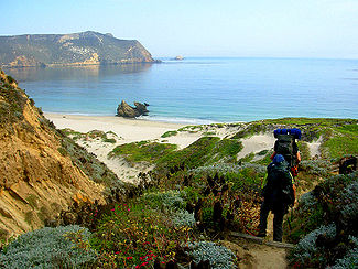
at Cuyler Harbor. Landing on the island can be an exciting experience, as the surf can swamp the landing boat. During ideal weather, visitors are put ashore directly in front of the trail that leads into the interior of the island. When the swell is high, visitors might be placed on the beach to the east or west, depending upon conditions.
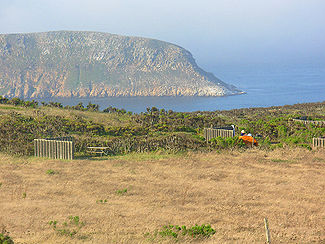
Camping facilities
Hiking
Hiking
Hiking is an outdoor activity which consists of walking in natural environments, often in mountainous or other scenic terrain. People often hike on hiking trails. It is such a popular activity that there are numerous hiking organizations worldwide. The health benefits of different types of hiking...
is restricted to ranger-led outings. Many visitors participate in the 14 miles (22.5 km) round trip hike to Point Bennett to view the thousands of seal
Earless seal
The true seals or earless seals are one of the three main groups of mammals within the seal superfamily, Pinnipedia. All true seals are members of the family Phocidae . They are sometimes called crawling seals to distinguish them from the fur seals and sea lions of the family Otariidae...
s and sea lion
Sea Lion
Sea lions are pinnipeds characterized by external ear-flaps, long fore-flippers, the ability to walk on all fours, and short thick hair. Together with the fur seal, they comprise the family Otariidae, or eared seals. There are six extant and one extinct species in five genera...
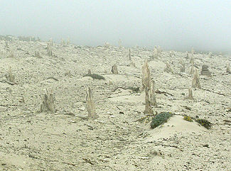
s that reside at the west end of the island during spring and summer. Another popular hike is to the Island's caliche
Caliche (Mineral)
Caliche is a sedimentary rock, a hardened deposit of calcium carbonate. This calcium carbonate cements together other materials, including gravel, sand, clay, and silt. It is found in aridisol and mollisol soil orders...
forest. Caliche is a type of hardened calcium deposit.
Water activities
Visitors to the island are restricted to ocean access at Cuyler Harbor. This landing is well protected from the strong ocean swell that is driven from the northwest. Cuyler has a sandy beach and visitors will often find themselves sharing the beach with elephant seals. The water is generally below 60 °F (16 °C), making it cold without a wetsuitWetsuit
A wetsuit is a garment, usually made of foamed neoprene, which is worn by surfers, divers, windsurfers, canoeists, and others engaged in water sports, providing thermal insulation, abrasion resistance and buoyancy. The insulation properties depend on bubbles of gas enclosed within the material,...
. During low tides the harbor offers a tide pool
Tide pool
Tide pools are rocky pools by oceans that are filled with seawater. Many of these pools exist as separate entities only at low tide.Tide pools are habitats of uniquely adaptable animals that have engaged the special attention of naturalists and marine biologists, as well as philosophical...
area at the east end of the beach. Sea kayak
Sea kayak
A sea kayak or touring kayak is a kayak developed for the sport of paddling on open waters of lakes, bays, and the ocean. Sea kayaks are seaworthy small boats with a covered deck and the ability to incorporate a spraydeck...
ing is not recommended for the novice as high winds can develop without notice.
Fauna
According to the Los Angeles Times, "Great white sharkGreat white shark
The great white shark, scientific name Carcharodon carcharias, also known as the great white, white pointer, white shark, or white death, is a large lamniform shark found in coastal surface waters in all major oceans. It is known for its size, with the largest individuals known to have approached...
s haunt the waters around San Miguel Island, where they feast on seals and sea lions." An urchin diver named James Robinson is believed to have been killed by a shark off Harris Point in the area known as Shark Park in 1994.
See also
- Chumash people
- Santa Barbara ChannelSanta Barbara ChannelThe Santa Barbara Channel is a portion of the Pacific Ocean which separates the mainland of California from the northern Channel Islands. It is generally south of the city of Santa Barbara, and west of the city of Ventura....
- SS Cuba (1920)SS Cuba (1920)The Cuba was a steamship owned by the Pacific Mail Steamship Company. Originally launched in 1897 as the German SS Coblenz, she was seized by the United States in 1917, and named SS Sachem, until Pacific Mail purchased her from the Shipping Board on 6 February 1920 for US$400,000 and renamed SS...