
Lake Winnipeg
Encyclopedia
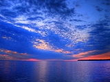
Lake Winnipeg is a large, 24514 square kilometres (9,464.9 sq mi) lake
in central North America
, in the province
of Manitoba
, Canada
, with its southern tip about 55 kilometres (34.2 mi) north of the city of Winnipeg. It is the largest lake within the borders of southern Canada, and it is part of the most undeveloped large watershed of southern Canada.
Lake Winnipeg is the sixth-largest freshwater lake in Canada, but it is relatively shallow (mean depth of 12 m (39 ft)) excluding a narrow 36 m (118 ft) deep channel between the northern and southern basins. It is the eleventh-largest freshwater lake on Earth. The east side of the lake has pristine boreal forests and rivers that are being promoted as a potential United Nations World Heritage Park. The lake is elongated in shape and is 416 km (258 mi) from north to south, with remote sandy beaches, large limestone cliffs, and many bat caves in some areas. Manitoba Hydro
uses the lake as one of the largest reservoirs in the world. There are many islands in the lake, most of them undeveloped.
measures about 984200 square kilometres (380,001.7 sq mi), and covers much of Alberta
, Saskatchewan
, Manitoba
, northwestern Ontario
, Minnesota
, and North Dakota
. Some of its tributaries include:
Lake Winnipeg drains northward into the Nelson River
at an average annual rate of 2,066 cubic metres per second (72,960 cu ft/s), and forms part of the Hudson Bay
watershed, which is one of the largest in the world. This watershed area was historically known as Rupert's Land
when the Hudson's Bay Company
was chartered in 1670
.
 Lake Winnipeg and Lake Manitoba
are remnants of prehistoric Glacial Lake Agassiz
. The area between the lakes is called the Interlake Region, and the whole region is called the Manitoba Lowlands.
It is believed that Henry Kelsey
was the first European to see the lake, in 1690. He adopted the Cree language
name for the lake: wīnipēk (ᐐᓂᐯᐠ), meaning "muddy waters". La Vérendrye referred to the lake as Ouinipigon when he built the first forts in the area in the 1730s. Later, the Red River Colony
to its south took the lake's name for Winnipeg
, the capital of Manitoba.
Lake Winnipeg lies along one of the oldest trading routes in North America
to have flown the British flag. For several centuries, furs were traded along this route between York Factory on Hudson Bay
(which was the longtime headquarters for the Hudson's Bay Company
) over Lake Winnipeg and the Red River Trails
to the confluence of the Minnesota
and Mississippi River
s at Saint Paul, Minnesota
. This was a strategic trading route for the First British Empire. With the establishment of the Second British Empire that occurred after Britain's loss of the Thirteen Colonies
, a quite significant increase in trade occurred over Lake Winnipeg between Rupert's Land
and the United States
.
 Because of its long, narrow shape, the lake exhibits a variety of interesting wind
and wave effects, including temporary water level rises of up to one metre in height at its southern shore, a process called seiche
. This occurs when prevailing northerly winds blow along the length of Lake Winnipeg, exerting a horizontal stress on its surface. Surface waters move in the direction of the wind and pile up along the leeward south shores.
Furthermore, water depths are known to be extremely variable at the south end of the lake. Many of the recreational beaches on the southern end of the lake feature rustic, seasonal piers for swimmers. It is not uncommon to be able to walk off the end of one of these piers one day into more than waist-deep water, then return a few days later to the same spot to find the water only ankle deep, or even exposed sand.
Setups greater than 1 m above normal lake levels have been recorded along many of southern Lake Winnipeg's recreational beaches, and the associated high waves with their uprush effects have caused considerable storm damage, backshore flood
and shoreline erosion
. The highest setups occur in the fall, when the northerly winds are strongest.
, caused by excessive amounts of nitrogen and phosphorus seeping into the lake. The pollution is now so bad that it is reaching a dangerous point for human health.
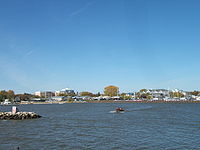
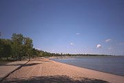
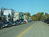 Communities on the lake include Grand Beach, Lester Beach, Riverton
, Gimli
, Winnipeg Beach, Victoria Beach
, Pine Falls, Manigotagan
, Berens River
, Bloodvein
, and Grand Rapids
. A number of pleasure beaches are found on the southern end of the lake, which are popular in the summer, attracting many visitors from Winnipeg, about 80 km south.
in Canada, which is why the fish is sometimes called Winnipeg goldeye. Common carp
were introduced to the lake through the Red River of the North
and are firmly established. Walleye
(often mistakenly called Pickerel
in Manitoba) and whitefish
together account for over 90 percent of its commercial fishing.
s, several steamboats plied the lake, including Anson Northup, City of Selkirk, Colvile
, Keenora, Premier, Princess
, Winnitoba, Wolverine and most recently the diesel powered MS Lord Selkirk II
passenger cruise ship.
Lake
A lake is a body of relatively still fresh or salt water of considerable size, localized in a basin, that is surrounded by land. Lakes are inland and not part of the ocean and therefore are distinct from lagoons, and are larger and deeper than ponds. Lakes can be contrasted with rivers or streams,...
in central North America
North America
North America is a continent wholly within the Northern Hemisphere and almost wholly within the Western Hemisphere. It is also considered a northern subcontinent of the Americas...
, in the province
Provinces and territories of Canada
The provinces and territories of Canada combine to make up the world's second-largest country by area. There are ten provinces and three territories...
of Manitoba
Manitoba
Manitoba is a Canadian prairie province with an area of . The province has over 110,000 lakes and has a largely continental climate because of its flat topography. Agriculture, mostly concentrated in the fertile southern and western parts of the province, is vital to the province's economy; other...
, Canada
Canada
Canada is a North American country consisting of ten provinces and three territories. Located in the northern part of the continent, it extends from the Atlantic Ocean in the east to the Pacific Ocean in the west, and northward into the Arctic Ocean...
, with its southern tip about 55 kilometres (34.2 mi) north of the city of Winnipeg. It is the largest lake within the borders of southern Canada, and it is part of the most undeveloped large watershed of southern Canada.
Lake Winnipeg is the sixth-largest freshwater lake in Canada, but it is relatively shallow (mean depth of 12 m (39 ft)) excluding a narrow 36 m (118 ft) deep channel between the northern and southern basins. It is the eleventh-largest freshwater lake on Earth. The east side of the lake has pristine boreal forests and rivers that are being promoted as a potential United Nations World Heritage Park. The lake is elongated in shape and is 416 km (258 mi) from north to south, with remote sandy beaches, large limestone cliffs, and many bat caves in some areas. Manitoba Hydro
Manitoba Hydro
Manitoba Hydro is the electric power and natural gas utility in the province of Manitoba, Canada. Founded in 1961, it is a provincial Crown Corporation, governed by the Manitoba Hydro-Electric Board and the Manitoba Hydro Act. Today the company operates 15 interconnected generating stations. It has...
uses the lake as one of the largest reservoirs in the world. There are many islands in the lake, most of them undeveloped.
Watershed
The lake's watershedDrainage basin
A drainage basin is an extent or an area of land where surface water from rain and melting snow or ice converges to a single point, usually the exit of the basin, where the waters join another waterbody, such as a river, lake, reservoir, estuary, wetland, sea, or ocean...
measures about 984200 square kilometres (380,001.7 sq mi), and covers much of Alberta
Alberta
Alberta is a province of Canada. It had an estimated population of 3.7 million in 2010 making it the most populous of Canada's three prairie provinces...
, Saskatchewan
Saskatchewan
Saskatchewan is a prairie province in Canada, which has an area of . Saskatchewan is bordered on the west by Alberta, on the north by the Northwest Territories, on the east by Manitoba, and on the south by the U.S. states of Montana and North Dakota....
, Manitoba
Manitoba
Manitoba is a Canadian prairie province with an area of . The province has over 110,000 lakes and has a largely continental climate because of its flat topography. Agriculture, mostly concentrated in the fertile southern and western parts of the province, is vital to the province's economy; other...
, northwestern Ontario
Ontario
Ontario is a province of Canada, located in east-central Canada. It is Canada's most populous province and second largest in total area. It is home to the nation's most populous city, Toronto, and the nation's capital, Ottawa....
, Minnesota
Minnesota
Minnesota is a U.S. state located in the Midwestern United States. The twelfth largest state of the U.S., it is the twenty-first most populous, with 5.3 million residents. Minnesota was carved out of the eastern half of the Minnesota Territory and admitted to the Union as the thirty-second state...
, and North Dakota
North Dakota
North Dakota is a state located in the Midwestern region of the United States of America, along the Canadian border. The state is bordered by Canada to the north, Minnesota to the east, South Dakota to the south and Montana to the west. North Dakota is the 19th-largest state by area in the U.S....
. Some of its tributaries include:
- Saskatchewan RiverSaskatchewan RiverThe Saskatchewan River is a major river in Canada, approximately long, flowing roughly eastward across Saskatchewan and Manitoba to empty into Lake Winnipeg...
(through Cedar LakeCedar Lake (Manitoba)Cedar Lake is a lake just north of Lake Winnipegosis in Manitoba, Canada. Cedar Lake's water level is controlled by the Grand Rapids dam. The town of Grand Rapids and the First Nations town of Easterville are nearby....
) - Red RiverRed River of the NorthThe Red River is a North American river. Originating at the confluence of the Bois de Sioux and Otter Tail rivers in the United States, it flows northward through the Red River Valley and forms the border between the U.S. states of Minnesota and North Dakota before continuing into Manitoba, Canada...
(including Assiniboine RiverAssiniboine RiverThe Assiniboine River is a river that runs through the prairies of Western Canada in Saskatchewan and Manitoba. It is a tributary of the Red River. The Assiniboine is a typical meandering river with a single main channel embanked within a flat, shallow valley in some places and a steep valley in...
) - Winnipeg RiverWinnipeg RiverThe Winnipeg River is a Canadian river which flows from Lake of the Woods in the province of Ontario to Lake Winnipeg in Manitoba. This river is long from the Norman Dam in Kenora to its mouth at Lake Winnipeg. Its watershed is in area, mainly in Canada. About of this area is in northern...
(draining Lake of the WoodsLake of the WoodsLake of the Woods is a lake occupying parts of the Canadian provinces of Ontario and Manitoba and the U.S. state of Minnesota. It separates a small land area of Minnesota from the rest of the United States. The Northwest Angle and the town of Angle Township can only be reached from the rest of...
, Rainy RiverRainy River (Minnesota-Ontario)The Rainy River is a river, approximately long, which forms part of the U.S.-Canada border separating northern Minnesota and Northwestern Ontario....
and Rainy LakeRainy LakeRainy Lake is a relatively large freshwater lake that straddles the border between the United States and Canada. The Rainy River issues from the west side of the lake and is harnessed to make hydroelectricity for US and Canadian locations. The U.S...
) - Dauphin RiverDauphin RiverThe Dauphin River is a river of Manitoba, Canada. The Dauphin is part of the connection from Lake Manitoba to Lake Winnipeg. The Fairford River flows from Portage Bay in Lake Manitoba through to Lake St. Martin then the Dauphin River continues northeastward from Lake St. Martin into Lake Winnipeg....
, (draining Lake ManitobaLake ManitobaLake Manitoba is Canada's thirteenth largest lake and the world's 33rd largest freshwater lake. It is in central North America, in the Canadian province of Manitoba, which is named after the lake...
and Lake WinnipegosisLake WinnipegosisLake Winnipegosis is a large lake in central North America, in Manitoba, Canada, some 300 km northwest of Winnipeg. It is Canada's eleventh-largest lake...
) - Bloodvein RiverBloodvein RiverThe Bloodvein River is a pristine river on the east side of Lake Winnipeg, in Ontario and Manitoba, Canada. This wilderness area has no logging roads, mines, or hydro developments nearby. Many native locals and tourists enjoy canoeing and fishing in this remote and clean river...
(on the East side, draining from the Canadian ShieldCanadian ShieldThe Canadian Shield, also called the Laurentian Plateau, or Bouclier Canadien , is a vast geological shield covered by a thin layer of soil that forms the nucleus of the North American or Laurentia craton. It is an area mostly composed of igneous rock which relates to its long volcanic history...
) - Poplar RiverPoplar River (Manitoba)Poplar River runs towards the eastern shore of Lake Winnipeg, in Manitoba, Canada. This river, which flows west into Lake Winnipeg, has a watershed beginning near the Manitoba and Ontario border...
- Manigotagan River
Lake Winnipeg drains northward into the Nelson River
Nelson River
The Nelson River is a river of north-central North America, in the Canadian province of Manitoba. Its full length is , it has mean discharge of , and has a drainage basin of , of which is in the United States...
at an average annual rate of 2,066 cubic metres per second (72,960 cu ft/s), and forms part of the Hudson Bay
Hudson Bay
Hudson Bay , sometimes called Hudson's Bay, is a large body of saltwater in northeastern Canada. It drains a very large area, about , that includes parts of Ontario, Quebec, Saskatchewan, Alberta, most of Manitoba, southeastern Nunavut, as well as parts of North Dakota, South Dakota, Minnesota,...
watershed, which is one of the largest in the world. This watershed area was historically known as Rupert's Land
Rupert's Land
Rupert's Land, or Prince Rupert's Land, was a territory in British North America, consisting of the Hudson Bay drainage basin that was nominally owned by the Hudson's Bay Company for 200 years from 1670 to 1870, although numerous aboriginal groups lived in the same territory and disputed the...
when the Hudson's Bay Company
Hudson's Bay Company
The Hudson's Bay Company , abbreviated HBC, or "The Bay" is the oldest commercial corporation in North America and one of the oldest in the world. A fur trading business for much of its existence, today Hudson's Bay Company owns and operates retail stores throughout Canada...
was chartered in 1670
Royal Charter
A royal charter is a formal document issued by a monarch as letters patent, granting a right or power to an individual or a body corporate. They were, and are still, used to establish significant organizations such as cities or universities. Charters should be distinguished from warrants and...
.
History
Lake Manitoba
Lake Manitoba is Canada's thirteenth largest lake and the world's 33rd largest freshwater lake. It is in central North America, in the Canadian province of Manitoba, which is named after the lake...
are remnants of prehistoric Glacial Lake Agassiz
Lake Agassiz
Lake Agassiz was an immense glacial lake located in the center of North America. Fed by glacial runoff at the end of the last glacial period, its area was larger than all of the modern Great Lakes combined, and it held more water than contained by all lakes in the world today.-Conception:First...
. The area between the lakes is called the Interlake Region, and the whole region is called the Manitoba Lowlands.
It is believed that Henry Kelsey
Henry Kelsey
Henry Kelsey , aka the Boy Kelsey, was an English fur trader, explorer, and sailor who played an important role in establishing the Hudson's Bay Company. Kelsey was born and married in East Greenwich, south-east of central London...
was the first European to see the lake, in 1690. He adopted the Cree language
Cree language
Cree is an Algonquian language spoken by approximately 117,000 people across Canada, from the Northwest Territories and Alberta to Labrador, making it the aboriginal language with the highest number of speakers in Canada. It is also spoken in the U.S. state of Montana...
name for the lake: wīnipēk (ᐐᓂᐯᐠ), meaning "muddy waters". La Vérendrye referred to the lake as Ouinipigon when he built the first forts in the area in the 1730s. Later, the Red River Colony
Red River Colony
The Red River Colony was a colonization project set up by Thomas Douglas, 5th Earl of Selkirk in 1811 on of land granted to him by the Hudson's Bay Company under what is referred to as the Selkirk Concession. The colony along the Red River of the North was never very successful...
to its south took the lake's name for Winnipeg
Winnipeg
Winnipeg is the capital and largest city of Manitoba, Canada, and is the primary municipality of the Winnipeg Capital Region, with more than half of Manitoba's population. It is located near the longitudinal centre of North America, at the confluence of the Red and Assiniboine Rivers .The name...
, the capital of Manitoba.
Lake Winnipeg lies along one of the oldest trading routes in North America
North America
North America is a continent wholly within the Northern Hemisphere and almost wholly within the Western Hemisphere. It is also considered a northern subcontinent of the Americas...
to have flown the British flag. For several centuries, furs were traded along this route between York Factory on Hudson Bay
Hudson Bay
Hudson Bay , sometimes called Hudson's Bay, is a large body of saltwater in northeastern Canada. It drains a very large area, about , that includes parts of Ontario, Quebec, Saskatchewan, Alberta, most of Manitoba, southeastern Nunavut, as well as parts of North Dakota, South Dakota, Minnesota,...
(which was the longtime headquarters for the Hudson's Bay Company
Hudson's Bay Company
The Hudson's Bay Company , abbreviated HBC, or "The Bay" is the oldest commercial corporation in North America and one of the oldest in the world. A fur trading business for much of its existence, today Hudson's Bay Company owns and operates retail stores throughout Canada...
) over Lake Winnipeg and the Red River Trails
Red River Trails
The Red River Trails were a network of ox cart routes connecting the Red River Colony and Fort Garry in British North America with the head of navigation on the Mississippi River in the United States...
to the confluence of the Minnesota
Minnesota River
The Minnesota River is a tributary of the Mississippi River, approximately 332 miles long, in the U.S. state of Minnesota. It drains a watershed of nearly , in Minnesota and about in South Dakota and Iowa....
and Mississippi River
Mississippi River
The Mississippi River is the largest river system in North America. Flowing entirely in the United States, this river rises in western Minnesota and meanders slowly southwards for to the Mississippi River Delta at the Gulf of Mexico. With its many tributaries, the Mississippi's watershed drains...
s at Saint Paul, Minnesota
Saint Paul, Minnesota
Saint Paul is the capital and second-most populous city of the U.S. state of Minnesota. The city lies mostly on the east bank of the Mississippi River in the area surrounding its point of confluence with the Minnesota River, and adjoins Minneapolis, the state's largest city...
. This was a strategic trading route for the First British Empire. With the establishment of the Second British Empire that occurred after Britain's loss of the Thirteen Colonies
Thirteen Colonies
The Thirteen Colonies were English and later British colonies established on the Atlantic coast of North America between 1607 and 1733. They declared their independence in the American Revolution and formed the United States of America...
, a quite significant increase in trade occurred over Lake Winnipeg between Rupert's Land
Rupert's Land
Rupert's Land, or Prince Rupert's Land, was a territory in British North America, consisting of the Hudson Bay drainage basin that was nominally owned by the Hudson's Bay Company for 200 years from 1670 to 1870, although numerous aboriginal groups lived in the same territory and disputed the...
and the United States
United States
The United States of America is a federal constitutional republic comprising fifty states and a federal district...
.
Water conditions
Wind
Wind is the flow of gases on a large scale. On Earth, wind consists of the bulk movement of air. In outer space, solar wind is the movement of gases or charged particles from the sun through space, while planetary wind is the outgassing of light chemical elements from a planet's atmosphere into space...
and wave effects, including temporary water level rises of up to one metre in height at its southern shore, a process called seiche
Seiche
A seiche is a standing wave in an enclosed or partially enclosed body of water. Seiches and seiche-related phenomena have been observed on lakes, reservoirs, swimming pools, bays, harbors and seas...
. This occurs when prevailing northerly winds blow along the length of Lake Winnipeg, exerting a horizontal stress on its surface. Surface waters move in the direction of the wind and pile up along the leeward south shores.
Furthermore, water depths are known to be extremely variable at the south end of the lake. Many of the recreational beaches on the southern end of the lake feature rustic, seasonal piers for swimmers. It is not uncommon to be able to walk off the end of one of these piers one day into more than waist-deep water, then return a few days later to the same spot to find the water only ankle deep, or even exposed sand.
Setups greater than 1 m above normal lake levels have been recorded along many of southern Lake Winnipeg's recreational beaches, and the associated high waves with their uprush effects have caused considerable storm damage, backshore flood
Flood
A flood is an overflow of an expanse of water that submerges land. The EU Floods directive defines a flood as a temporary covering by water of land not normally covered by water...
and shoreline erosion
Erosion
Erosion is when materials are removed from the surface and changed into something else. It only works by hydraulic actions and transport of solids in the natural environment, and leads to the deposition of these materials elsewhere...
. The highest setups occur in the fall, when the northerly winds are strongest.
Algae population and pollution
Lake Winnipeg is suffering from many environmental issues such as an explosion in the population of algaeAlgae
Algae are a large and diverse group of simple, typically autotrophic organisms, ranging from unicellular to multicellular forms, such as the giant kelps that grow to 65 meters in length. They are photosynthetic like plants, and "simple" because their tissues are not organized into the many...
, caused by excessive amounts of nitrogen and phosphorus seeping into the lake. The pollution is now so bad that it is reaching a dangerous point for human health.
Communities
Riverton, Manitoba
Riverton is a village in the province of Manitoba in Canada located approximately 110 kilometres north of Winnipeg. It is surrounded by the Rural Municipality of Bifrost. The CPR's train conductor is reputed to have named the town....
, Gimli
Gimli, Manitoba
Gimli is a a rural municipality located in the Interlake region of south-central Manitoba, Canada, on the western shore of Lake Winnipeg. It is about north of the provincial capital Winnipeg...
, Winnipeg Beach, Victoria Beach
Victoria Beach, Manitoba
Victoria Beach is a rural municipality located on the southeastern shores of Lake Winnipeg. It is approximately north of Winnipeg, the provincial capital of Manitoba, Canada. Its land area is 20.279 km² , making it the smallest rural municipality in Manitoba. It is slightly less than half the size...
, Pine Falls, Manigotagan
Manigotagan, Manitoba
Manigotagan is a community in the Canadian province of Manitoba. A designated place in Canadian census data, the community had a population of 191 in the Canada 2006 Census....
, Berens River
Berens River, Manitoba
Berens River is located in Manitoba, Canada, along the eastern shore of Lake Winnipeg. This community is near the mouth of the Berens River, which flows west from the Ontario headwaters...
, Bloodvein
Bloodvein First Nation
The Bloodvein First Nation is located on the east side of Lake Winnipeg, along the Bloodvein River in Manitoba, Canada. This area is a part of Treaty 5, and has long been inhabited by native peoples. The name “Bloodvein” was used in an 1818-19 Hudson's Bay Company journal...
, and Grand Rapids
Grand Rapids, Manitoba
Grand Rapids is a town in Manitoba, Canada located on the northwestern shore of Lake Winnipeg where the Saskatchewan River enters the lake. As the name implies, the river had a significant drop at this point . In modern days, a large hydro electric generating plant has been built...
. A number of pleasure beaches are found on the southern end of the lake, which are popular in the summer, attracting many visitors from Winnipeg, about 80 km south.
Fishing
Lake Winnipeg has important commercial fisheries. Its catch makes up a major part of Manitoba's $30 million-a-year fishing industry. The lake was once the main source of goldeyeGoldeye
The goldeye, Hiodon alosoides, is a species of fish in the mooneye family . It occurs from as far down the Mackenzie River as Aklavik in the north to Mississippi in the south, and from Alberta in the west to Ohio south of the Great Lakes, with an isolated population south of James Bay. It is...
in Canada, which is why the fish is sometimes called Winnipeg goldeye. Common carp
Common carp
The Common carp is a widespread freshwater fish of eutrophic waters in lakes and large rivers in Europe and Asia. The wild populations are considered vulnerable to extinction, but the species has also been domesticated and introduced into environments worldwide, and is often considered an invasive...
were introduced to the lake through the Red River of the North
Red River of the North
The Red River is a North American river. Originating at the confluence of the Bois de Sioux and Otter Tail rivers in the United States, it flows northward through the Red River Valley and forms the border between the U.S. states of Minnesota and North Dakota before continuing into Manitoba, Canada...
and are firmly established. Walleye
Walleye
Walleye is a freshwater perciform fish native to most of Canada and to the northern United States. It is a North American close relative of the European pikeperch...
(often mistakenly called Pickerel
Pickerel
Pickerel may refer to:*Esox, the genus of fish commonly known as the pickerels which includes pike and muskellunge as well as other pickerel*American pickerel*Chain pickerel*Walleye, or Yellow Pickerel * Pickerel Frog...
in Manitoba) and whitefish
Whitefish
Whitefish or white fish may refer to:In fishing terminology:* Whitefish , a fisheries term referring to the flesh of many types of fishIn fish species:...
together account for over 90 percent of its commercial fishing.
Transportation
Because of its length the Lake Winnipeg water system and the lake itself was an important transportation route in the province before the railways reached Manitoba. It continued to be a major transportation route even after the railways reached the province. In addition to aboriginal canoes and York boatYork boat
The York boat was an inland boat used by the Hudson's Bay Company to carry furs and trade goods along inland waterways in Rupert's Land and the Columbia District. It was named after York Factory, the headquarters of the HBC, and modeled after Orkney Islands fishing boats...
s, several steamboats plied the lake, including Anson Northup, City of Selkirk, Colvile
SS Colvile
The SS Colvile was a Lake Winnipeg steamboat built for the Hudson's Bay Company in Grand Forks, North Dakota. Parts of the vessel called Chief Commissioner were used for the Colvile. The Colvile was one of the largest vessels constructed for the HBC. The company hired Captain J...
, Keenora, Premier, Princess
SS Princess
SS Princess was a steamboat that operated on Lake Winnipeg in Canada from 1881 until 1906. The vessel was built in Winnipeg, Manitoba by the Jarvis & Burridge shipyard, and it was regarded as the pride of Lake Winnipeg and as the finest lake steamer west from the Great Lakes and east from the Rocky...
, Winnitoba, Wolverine and most recently the diesel powered MS Lord Selkirk II
MS Lord Selkirk II
The MS Lord Selkirk II was a passenger cruise ship that sailed the Red River and Lake Winnipeg in Manitoba, Canada. Lake Winnipeg's last cruise ship, she was the largest ever built between the Great Lakes and the Rockies, with accommodation for 130 passengers and 40 crew...
passenger cruise ship.