
Mistaya River
Encyclopedia
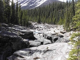
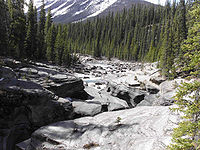
Mistaya River is a short river in western Alberta
, Canada
. It flows through the Canadian Rockies
, and a section of the Icefield Parkway was built along its course.
Mistaya River originates in Peyto Lake
, a glacial lake of typical blue colour (due to rock flour
). Mistaya flows north-west, receiving the waters of creeks such as Delta, Silverhorn, Cirque, Noyes, ChephrenTotem, Epaulette, Bison, Kaufmann and Sarback. A series of elongated lakes are formed along the river: Mistaya Lake and Waterfowl Lakes.
 Mistaya merges into the North Saskatchewan River
at Saskatchewan River Crossing
.
From its headwaters of Peyto Creek, Mistaya River has a total length of 38 km.
Alberta
Alberta is a province of Canada. It had an estimated population of 3.7 million in 2010 making it the most populous of Canada's three prairie provinces...
, Canada
Canada
Canada is a North American country consisting of ten provinces and three territories. Located in the northern part of the continent, it extends from the Atlantic Ocean in the east to the Pacific Ocean in the west, and northward into the Arctic Ocean...
. It flows through the Canadian Rockies
Canadian Rockies
The Canadian Rockies comprise the Canadian segment of the North American Rocky Mountains range. They are the eastern part of the Canadian Cordillera, extending from the Interior Plains of Alberta to the Rocky Mountain Trench of British Columbia. The southern end borders Idaho and Montana of the USA...
, and a section of the Icefield Parkway was built along its course.
Mistaya River originates in Peyto Lake
Peyto Lake
Peyto Lake is a glacier-fed lake located in Banff National Park in the Canadian Rockies. The lake itself is easily accessed from the Icefields Parkway...
, a glacial lake of typical blue colour (due to rock flour
Rock flour
Rock flour, or glacial flour, consists of fine-grained, silt-sized particles of rock, generated by mechanical grinding of bedrock by glacial erosion or by artificial grinding to a similar size...
). Mistaya flows north-west, receiving the waters of creeks such as Delta, Silverhorn, Cirque, Noyes, ChephrenTotem, Epaulette, Bison, Kaufmann and Sarback. A series of elongated lakes are formed along the river: Mistaya Lake and Waterfowl Lakes.
North Saskatchewan River
The North Saskatchewan River is a glacier-fed river that flows east from the Canadian Rockies to central Saskatchewan. It is one of two major rivers that join to make up the Saskatchewan River....
at Saskatchewan River Crossing
Saskatchewan River Crossing, Alberta
Saskatchewan River Crossing is a place name in western Alberta, Canada. It is located in the administrative area Improvement District No. 9 , at the junction between Icefields Parkway and David Thompson Highway....
.
From its headwaters of Peyto Creek, Mistaya River has a total length of 38 km.