
Athabasca River
Encyclopedia
The Athabasca River originates from the Columbia Glacier of the Columbia Icefield
in Jasper National Park
in Alberta
, Canada
. The impressive and scenic Athabasca Falls
is located upstream about 30 km (18.6 mi) from the Jasper townsite
.
In Woods Cree
, the word aðapaskāw means "[where] there are plants one after another", likely a reference to the spotty vegetation along the river.
 Sekani
, Shuswap
, Kootenay, Salish, Stoney and Cree
tribes hunted and fished along the river prior to the European colonization. From about 1778, the Athabasca River, the Clearwater River
, which enters the Athabasca River from the east at Fort McMurray, and the Methye Portage
were part of the main fur trade route from the Mackenzie River to the Great Lakes. See Canadian Canoe Routes (early)
.
David Thompson
and Thomas the Iroquois travelled through Athabasca Pass
in 1811. In 1862, the Athabasca Springs area was crossed during the Cariboo Goldrush
by the Overlander Party.
for its importance to the fur trade and the construction of railways and roads opening up the Canadian West
, as well as for its natural heritage.
at the toe of the Athabasca Glacier, between Mount Columbia
, Snow Dome
, and the Sir Winston Churchill Range
, at an altitude of approximately 1600 metres (5,249.3 ft).
 The river flows along icefields and through gorges, offering wildlife habitat on its shores and adjacent marshes. Throughout its course, it flows through or adjacent to numerous national
and provincial park
s, including Jasper National Park
, Fort Assiniboine Sandhills Wildland Provincial Park, Hubert Lake Wildland Provincial Park, La Biche River Wildland Provincial Park, Grand Rapids Wildland Provincial Park, Richardson River Dunes Wildland Provincial Park, and Wood Buffalo National Park
. Its course is marked by rapids, impeding navigation southwest of Fort McMurray.
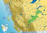
The Athabasca River travels 1231 km (764.9 mi) before draining into the Peace-Athabasca Delta
near Lake Athabasca
south of Fort Chipewyan
. From there, its waters flow north as Rivière des Rochers, then joining the Peace River
to form the Slave River
that empties into Great Slave Lake
and discharges through the Mackenzie River
system into the Arctic Ocean
. The cumulative drainage area is 95300 km² (36,795.5 sq mi).
Numerous communities are located on the banks of the Athabasca River, including Jasper
, Brule
, Entrance
, Hinton
, Whitecourt
, Fort Assiniboine, Smith
, Athabasca
, Fort McMurray, and Fort MacKay.
Central Alberta
Northern Alberta
downstream of the Athabasca oil sands
. Testing has shown this portion of the river contains mercury
, lead
and 11 other toxic elements.
named the position of Athabaska Herald
after the river.
Columbia Icefield
The Columbia Icefield is an icefield located in the Canadian Rockies, astride the Continental Divide of North America. The icefield lies partly in the northwestern tip of Banff National Park and the southern end of Jasper National Park. It is about 325 km² in area, 100 to 365 metres in depth and...
in Jasper National Park
Jasper National Park
Jasper National Park is the largest national park in the Canadian Rockies, spanning 10,878 km² . It is located in the province of Alberta, north of Banff National Park and west of the City of Edmonton. The park includes the glaciers of the Columbia Icefield, hot springs, lakes, waterfalls and...
in Alberta
Alberta
Alberta is a province of Canada. It had an estimated population of 3.7 million in 2010 making it the most populous of Canada's three prairie provinces...
, Canada
Canada
Canada is a North American country consisting of ten provinces and three territories. Located in the northern part of the continent, it extends from the Atlantic Ocean in the east to the Pacific Ocean in the west, and northward into the Arctic Ocean...
. The impressive and scenic Athabasca Falls
Athabasca Falls
Athabasca Falls is a waterfall in Jasper National Park on the upper Athabasca River, approximately 30 kilometres south of the townsite of Jasper, Alberta, and just west of the Icefields Parkway...
is located upstream about 30 km (18.6 mi) from the Jasper townsite
Jasper, Alberta
Jasper is a specialized municipality in western Alberta, Canada. It is the commercial centre of Jasper National Park, located in the Canadian Rockies in the Athabasca River valley....
.
In Woods Cree
Cree language
Cree is an Algonquian language spoken by approximately 117,000 people across Canada, from the Northwest Territories and Alberta to Labrador, making it the aboriginal language with the highest number of speakers in Canada. It is also spoken in the U.S. state of Montana...
, the word aðapaskāw means "[where] there are plants one after another", likely a reference to the spotty vegetation along the river.
History
Sekani
Sekani is the name of an Athabaskan First Nations people in the Northern Interior of British Columbia. Their territory includes the Finlay and Parsnip River drainages of the Rocky Mountain Trench. The neighbors of the Sekani are the Babine to the west, Dakelh to the south, Dunneza to the east, and...
, Shuswap
Secwepemc
The Secwepemc , known in English as the Shuswap people, are a First Nations people residing in the Canadian province of British Columbia. Their traditional territory ranges from the eastern Chilcotin Plateau and the Cariboo Plateau southeast through the Thompson Country to Kamloops and the Shuswap...
, Kootenay, Salish, Stoney and Cree
Cree
The Cree are one of the largest groups of First Nations / Native Americans in North America, with 200,000 members living in Canada. In Canada, the major proportion of Cree live north and west of Lake Superior, in Ontario, Manitoba, Saskatchewan, Alberta and the Northwest Territories, although...
tribes hunted and fished along the river prior to the European colonization. From about 1778, the Athabasca River, the Clearwater River
Clearwater River (Saskatchewan)
Clearwater River is the name of a river in the Canadian provinces of Saskatchewan and Alberta.-Course:The Clearwater River totals 295 kilometres in length and rises in northwestern Saskatchewan in the northern forest region of the Precambrian Shield. From its headwaters at Broach Lake it flows...
, which enters the Athabasca River from the east at Fort McMurray, and the Methye Portage
Methye Portage
The Methye Portage or Portage La Loche in northwestern Saskatchewan was one of the most important portages in the old fur-trade route across Canada. It connected the Mackenzie River basin to rivers that ran east to the Atlantic. It was reached by Peter Pond in 1778 and abandoned in 1883 when...
were part of the main fur trade route from the Mackenzie River to the Great Lakes. See Canadian Canoe Routes (early)
Canadian canoe routes (early)
This article covers the water routes used by early explorers of Canada with special emphasis on the fur trade.-Canada and Siberia:Both Canada and Siberia were explored mainly by river. Both countries have many navigable rivers with short portages between them. There are no serious barriers to canoe...
.
David Thompson
David Thompson (explorer)
David Thompson was an English-Canadian fur trader, surveyor, and map-maker, known to some native peoples as "Koo-Koo-Sint" or "the Stargazer"...
and Thomas the Iroquois travelled through Athabasca Pass
Athabasca Pass
Athabasca Pass is a high mountain pass in the Canadian Rockies. It is the headwaters of the Whirlpool River, a tributary of the Athabasca River.The pass lies between Mount Brown and McGillivray Ridge...
in 1811. In 1862, the Athabasca Springs area was crossed during the Cariboo Goldrush
Cariboo Gold Rush
The Cariboo Gold Rush was a gold rush in the Canadian province of British Columbia. Although the first gold discovery was made in 1859 at Horsefly Creek, followed by more strikes at Keithley Creek and Antler Horns lake in 1860, the actual rush did not begin until 1861, when these discoveries were...
by the Overlander Party.
Heritage
This river was designated a Canadian Heritage RiverCanadian Heritage Rivers System
The Canadian Heritage Rivers System was established in 1984 by the federal, provincial and territorial governments to conserve and protect the best examples of Canada's river heritage, to give them national recognition, and to encourage the public to enjoy and appreciate them. It is a cooperative...
for its importance to the fur trade and the construction of railways and roads opening up the Canadian West
Western Canada
Western Canada, also referred to as the Western provinces and commonly as the West, is a region of Canada that includes the four provinces west of the province of Ontario.- Provinces :...
, as well as for its natural heritage.
Course
The Athabasca River originates in Jasper National ParkJasper National Park
Jasper National Park is the largest national park in the Canadian Rockies, spanning 10,878 km² . It is located in the province of Alberta, north of Banff National Park and west of the City of Edmonton. The park includes the glaciers of the Columbia Icefield, hot springs, lakes, waterfalls and...
at the toe of the Athabasca Glacier, between Mount Columbia
Mount Columbia (Alberta)
Mount Columbia is the highest point in Alberta, Canada and the second highest peak in the Canadian Rockies after Mount Robson. It is located on the border between Alberta and British Columbia on the northern edge of the Columbia Icefield. Its highest point, however, lies within Jasper National Park...
, Snow Dome
Snow Dome (Canada)
Snow Dome is a mountain located on the Continental Divide in the Columbia Icefield, at the intersection of Banff National Park, and Jasper National Park, on the Alberta and British Columbia border in Canada.The mountain was named in 1898 by J...
, and the Sir Winston Churchill Range
Sir Winston Churchill Range
The Sir Winston Churchill Range is a mountain range in the Park Ranges of the Canadian Rockies located in Jasper National Park. The range was named after Sir Winston Churchill, former British prime minister....
, at an altitude of approximately 1600 metres (5,249.3 ft).
National park
A national park is a reserve of natural, semi-natural, or developed land that a sovereign state declares or owns. Although individual nations designate their own national parks differently A national park is a reserve of natural, semi-natural, or developed land that a sovereign state declares or...
and provincial park
Provincial park
A provincial park is a park under the management of a provincial or territorial government in Canada.While provincial parks are not the same as national parks, their workings are very similar...
s, including Jasper National Park
Jasper National Park
Jasper National Park is the largest national park in the Canadian Rockies, spanning 10,878 km² . It is located in the province of Alberta, north of Banff National Park and west of the City of Edmonton. The park includes the glaciers of the Columbia Icefield, hot springs, lakes, waterfalls and...
, Fort Assiniboine Sandhills Wildland Provincial Park, Hubert Lake Wildland Provincial Park, La Biche River Wildland Provincial Park, Grand Rapids Wildland Provincial Park, Richardson River Dunes Wildland Provincial Park, and Wood Buffalo National Park
Wood Buffalo National Park
Wood Buffalo National Park, located in northeastern Alberta and southern Northwest Territories, is the largest national park in Canada at . The park was established in 1922 to protect the world's largest herd of free roaming Wood Bison, currently estimated at more than 5,000...
. Its course is marked by rapids, impeding navigation southwest of Fort McMurray.
The Athabasca River travels 1231 km (764.9 mi) before draining into the Peace-Athabasca Delta
Peace-Athabasca Delta
The Peace–Athabasca Delta is a large freshwater, inland delta in northeastern Alberta located where the Peace and Athabasca Rivers join the Slave River at the western end of Lake Athabasca.-Conservation :...
near Lake Athabasca
Lake Athabasca
Lake Athabasca is located in the northwest corner of Saskatchewan and the northeast corner of Alberta between 58° and 60° N.-History:The name in the Dene language originally referred only to the large delta formed by the confluence the Athabasca River at the southwest corner of the lake...
south of Fort Chipewyan
Fort Chipewyan, Alberta
Fort Chipewyan, commonly referred to as Fort Chip, is a hamlet in northern Alberta, Canada within the Regional Municipality of Wood Buffalo. It is located on the western tip of Lake Athabasca, adjacent to Wood Buffalo National Park, approximately north of Fort McMurray.Fort Chipewyan is one of...
. From there, its waters flow north as Rivière des Rochers, then joining the Peace River
Peace River (Canada)
The Peace River is a river in Canada that originates in the Rocky Mountains of northern British Columbia and flows to the northeast through northern Alberta. The Peace River flows into the Slave River, a tributary of the Mackenzie River. The Mackenzie is the 12th longest river in the world,...
to form the Slave River
Slave River
The Slave River is a Canadian river that flows from Lake Athabasca in northeastern Alberta and empties into Great Slave Lake in the Northwest Territories....
that empties into Great Slave Lake
Great Slave Lake
Great Slave Lake is the second-largest lake in the Northwest Territories of Canada , the deepest lake in North America at , and the ninth-largest lake in the world. It is long and wide. It covers an area of in the southern part of the territory. Its given volume ranges from to and up to ...
and discharges through the Mackenzie River
Mackenzie River
The Mackenzie River is the largest river system in Canada. It flows through a vast, isolated region of forest and tundra entirely within the country's Northwest Territories, although its many tributaries reach into four other Canadian provinces and territories...
system into the Arctic Ocean
Arctic Ocean
The Arctic Ocean, located in the Northern Hemisphere and mostly in the Arctic north polar region, is the smallest and shallowest of the world's five major oceanic divisions...
. The cumulative drainage area is 95300 km² (36,795.5 sq mi).
Numerous communities are located on the banks of the Athabasca River, including Jasper
Jasper, Alberta
Jasper is a specialized municipality in western Alberta, Canada. It is the commercial centre of Jasper National Park, located in the Canadian Rockies in the Athabasca River valley....
, Brule
Brûlé, Alberta
Brûlé is a hamlet in west-central Alberta, Canada within Yellowhead County. It is located on the northwest shore of Brûlé Lake, approximately west of Hinton. It has an elevation of .Statistics Canada recognizes Brûlé as a designated place....
, Entrance
Entrance, Alberta
Entrance is an unincorporated community in central Alberta in Yellowhead County, located on Highway 40, northwest of Jasper.-References:...
, Hinton
Hinton, Alberta
Hinton is a town in west-central Alberta, Canada.It is located in Yellowhead County, northeast of Jasper and about west of Alberta's capital city, Edmonton, at the intersection of Yellowhead and Bighorn Highway, in the Athabasca River valley.-History:...
, Whitecourt
Whitecourt, Alberta
Whitecourt is a town in Alberta, Canada within Woodlands County. It is located northwest of Edmonton and southeast of Grande Prairie at the junction of Highway 43 and Highway 32 and has an elevation of ....
, Fort Assiniboine, Smith
Smith, Alberta
Smith is a hamlet in northern Alberta, Canada within the Municipal District of Lesser Slave River No. 124. It is located on Highway 2A, approximately northwest of Edmonton, at the confluence of the Lesser Slave River and the Athabasca River.- History :...
, Athabasca
Athabasca, Alberta
Athabasca is a town in northern Alberta, Canada. It lies north of Edmonton on Highway 2, on the banks of the Athabasca River. It is the centre of Athabasca County. Until 1913 it was known as Athabasca Landing.- History :...
, Fort McMurray, and Fort MacKay.
Tributaries
Alberta's RockiesAlberta's Rockies
Alberta's Rockies comprises the Canadian Rockies in the province of Alberta, Canada. It is a region on the southwestern part of the province, along the British Columbia border. It covers all but the south of Census Division 15....
- Habel Creek
- Warwick Creek
- Quincy Creek
- Chaba River
- Dragon Creek
- Sunwapta RiverSunwapta RiverThe Sunwapta River is a major tributary of the Athabasca River in Jasper National Park in Alberta, Canada.-Course:The headwaters of the Sunwapta River are near the Columbia Icefield in the valley west northwest of Sunwapta pass, which divides Jasper National Park from Banff National Park...
- Ranger Creek
- Fryatt Creek
- Lick Creek
- Geraldine Lakes
- Kerkeslin Creek
- Hardisty Creek
- Whirpool RiverWhirpool RiverThe Whirlpool River is a short river in Jasper National Park, Alberta, Canada. It is an early tributary of the Athabasca River.The Whirlpool is formed in Athabasca Pass, collecting meltwater from the Hooker Icefield and the Mount Brown Icefield...
- Astoria RiverAstoria RiverThe Astoria River is a short river in Jasper National Park, Alberta, Canada. It is an early tributary of the Athabasca River.The Astoria forms in the Tonquin Valley, collecting meltwater from the Fraser Glacier, the Ramparts, Mount Erebus, Mount Clithero, and Oldhorn Mountain.The Astoria River, as...
- Portal Creek
- Wabasso Creek
- Whistlers Creek
- Tekerra Creek
- Miette RiverMiette RiverThe Miette River is a short river in Jasper National Park, Alberta, Canada. It flows south-southwest through the Rocky Mountains before draining into the Athabasca River....
- Pyramid Lake
- Maligne RiverMaligne RiverThe Maligne River is a medium-sized river in the Canadian Rockies. It runs through parts of Jasper National Park in Alberta, Canada. The Maligne is a major tributary of the Athabasca River. The river takes from the French word for malignant or wicked...
- Garonne Creek
- Snaring RiverSnaring RiverThe Snaring River is a medium-sized river in the Canadian Rockies. It runs through parts of Jasper National Park in Alberta, Canada. The Snaring River is a significant tributary of the Athabasca River...
- Morro Creek
- Cobblestone Creek
- Corral Creek
- Jacques Creek
- Rocky River
- Snake Indian RiverSnake Indian RiverThe Snake Indian River is a large tributary of the Athabasca River, exiting entirely within Jasper National Park. The Snake Indian forms at Snake Indian Pass, south of Monte Christo Mountain and Snake Indian Mountain, north of Calumet Peak. The river travels in a general northwest direction before...
- Mountain Creek
- Fiddle RiverFiddle RiverThe Fiddle River is a medium-sized tributary of the Athabasca River, flowing into the river near the east gate of Jasper National Park. The Fiddle River forms at the base of Fiddle Pass, with meltwater from Mount Bryant, Mount Gregg, Mount Sir Harold Mitchel, and Mount Barry. The river flows in a...
- Supply Creek
- Oldhouse Creek
- Prine Creek
- Maskuta Creek
Central Alberta
Central Alberta
Central Alberta is a region located in the Canadian province of Alberta.Central Alberta is the most densely populated rural area in the province...
- Hardisty Creek
- Fish Creek
- Cache Petotte Creek
- Tiecamp Creek
- Canyon Creek
- Ponoka Creek
- Plante Creek
- Apetowun Creek
- Obed Creek
- Oldman Creek
- Nosehill Creek
- Jackpine Creek
- Berland River
- Wildhay River
- Beaver Creek
- Marsh Head Creek
- Pine Creek
- Pass Creek
- Two Creek
- Windfall Creek
- Chickadee Creek
- Bessie Creek
- Stony Creek
- Sakwatamau River
- McLeod RiverMcLeod RiverMcleod River is a significant river in west-central Alberta, Canada. It forms in the foothills of the Canadian Rockies, and is a major tributary of the Athabasca River.-Course:...
Northern Alberta
Northern Alberta
Northern Alberta is a region located in the Canadian province of Alberta.Its primary industry is oil and gas, with large heavy oil reserves being exploited at the Athabasca Oil Sands and Wabasca Area in the east of the region...
- Freeman RiverFreeman RiverThe Freeman River is a short river in west-central Alberta. The Freeman takes its name from the fur traders, who, after leaving the employ of the Hudson's Bay Company or the North West Company, decided to remain in the interior and work as free trappers or free hunters.-Course:The river flows in a...
- Timeu Creek
- Pembina RiverPembina River (Alberta)Pembina is a river in central Alberta, Canada. It is a tributary of the Athabasca River.Pembina is a Canadian French name for the high bush cranberry . The river gives the name to the Pembina oil field,an oil and gas producing region centered around Drayton Valley...
- Lesser Slave RiverLesser Slave RiverLesser Slave River is a river in central Alberta, Canada. It is a major tributary of the Athabasca River....
- Lawrence Lake Creek
- Baptiste Lake Creek
- Tawatinaw River
- La Biche River
- Calling River
- McMillan Lake Creek
- Parallel Creek
- Pelican River
- House River
- Horse River
- Clearwater RiverClearwater River (Saskatchewan)Clearwater River is the name of a river in the Canadian provinces of Saskatchewan and Alberta.-Course:The Clearwater River totals 295 kilometres in length and rises in northwestern Saskatchewan in the northern forest region of the Precambrian Shield. From its headwaters at Broach Lake it flows...
- Steepbank River
- Muskeg River
- Mackay River
- Ells River
- Firebag RiverFirebag RiverFirebag is a river in northern Alberta and Saskatchewan, Canada. It gets its name from the traditional bags Aboriginals once used to carry fire-starting flints....
- Richardson River
Effect of oil sands
An independent study has concluded that the Athabasca River contains elevated levels of pollutionPollution
Pollution is the introduction of contaminants into a natural environment that causes instability, disorder, harm or discomfort to the ecosystem i.e. physical systems or living organisms. Pollution can take the form of chemical substances or energy, such as noise, heat or light...
downstream of the Athabasca oil sands
Athabasca Oil Sands
The Athabasca oil sands are large deposits of bitumen, or extremely heavy crude oil, located in northeastern Alberta, Canada - roughly centred on the boomtown of Fort McMurray...
. Testing has shown this portion of the river contains mercury
Mercury (element)
Mercury is a chemical element with the symbol Hg and atomic number 80. It is also known as quicksilver or hydrargyrum...
, lead
Lead
Lead is a main-group element in the carbon group with the symbol Pb and atomic number 82. Lead is a soft, malleable poor metal. It is also counted as one of the heavy metals. Metallic lead has a bluish-white color after being freshly cut, but it soon tarnishes to a dull grayish color when exposed...
and 11 other toxic elements.
Legacy
The Canadian Heraldic AuthorityCanadian Heraldic Authority
The Canadian Heraldic Authority is part of the Canadian honours system under the Queen of Canada, whose authority is exercised by the Governor General. The Authority is responsible for the creation and granting of new coats of arms , flags and badges for Canadian citizens, permanent residents and...
named the position of Athabaska Herald
Athabaska Herald
Athabaska Herald of Arms is the title of one of the officers of arms at the Canadian Heraldic Authority in Ottawa. Like the other heralds at the Authority, the name is derived from that of a Canadian river. The design of the badge of office of Athabaska Herald of Arms is based on the floral...
after the river.
See also
- Geography of AlbertaGeography of AlbertaAlberta is a Canadian province. Located in Western Canada, the province has an area of and is bounded to the south by the U.S. state of Montana along 49° north for ; to the east at 110° west by the province of Saskatchewan for ; and at 60° north the Northwest Territories for...
- List of Alberta rivers
- List of longest rivers of Canada