
Abraham Lake
Encyclopedia
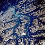
Abraham Lake is an artificial lake
on North Saskatchewan River
in western Alberta
, Canada
. Abraham Lake has a surface area of 53.7 km² (20.7 sq mi) and a length of 32 km (19.9 mi).
of the Canadian Rockies
. It lines David Thompson Highway between Saskatchewan River Crossing
and Nordegg
.
Abraham Lake was created in 1972, with the construction of the Bighorn Dam
. The Government of Alberta sponsored a contest to name the lake in during February 1972, during the final stages of construction of the Bighorn dam. Students across the province were asked to submit names taking into consideration "historical significance, prominent persons, geography and topography, and the value of the lake." It was named for Silas Abraham, an inhabitant of the Saskatchewan River valley in the nineteenth century.
Although man-made, the lake has the blue color of other glacial lakes in the Rocky Mountains
, which is caused by rock flour
as in other glacial lakes.
The Cline River Heliport is located on the western shore of the lake.
Lake
A lake is a body of relatively still fresh or salt water of considerable size, localized in a basin, that is surrounded by land. Lakes are inland and not part of the ocean and therefore are distinct from lagoons, and are larger and deeper than ponds. Lakes can be contrasted with rivers or streams,...
on North Saskatchewan River
North Saskatchewan River
The North Saskatchewan River is a glacier-fed river that flows east from the Canadian Rockies to central Saskatchewan. It is one of two major rivers that join to make up the Saskatchewan River....
in western Alberta
Alberta
Alberta is a province of Canada. It had an estimated population of 3.7 million in 2010 making it the most populous of Canada's three prairie provinces...
, Canada
Canada
Canada is a North American country consisting of ten provinces and three territories. Located in the northern part of the continent, it extends from the Atlantic Ocean in the east to the Pacific Ocean in the west, and northward into the Arctic Ocean...
. Abraham Lake has a surface area of 53.7 km² (20.7 sq mi) and a length of 32 km (19.9 mi).
History
It was built on the upper course of the North Saskatchewan River, in the foothillsFoothills
Foothills are geographically defined as gradual increases in elevation at the base of a mountain range. They are a transition zone between plains and low relief hills to the adjacent topographically high mountains.-Examples:...
of the Canadian Rockies
Canadian Rockies
The Canadian Rockies comprise the Canadian segment of the North American Rocky Mountains range. They are the eastern part of the Canadian Cordillera, extending from the Interior Plains of Alberta to the Rocky Mountain Trench of British Columbia. The southern end borders Idaho and Montana of the USA...
. It lines David Thompson Highway between Saskatchewan River Crossing
Saskatchewan River Crossing, Alberta
Saskatchewan River Crossing is a place name in western Alberta, Canada. It is located in the administrative area Improvement District No. 9 , at the junction between Icefields Parkway and David Thompson Highway....
and Nordegg
Nordegg, Alberta
Nordegg is a hamlet in west-central Alberta, Canada within Clearwater County. It is located in the North Saskatchewan River valley in the foothills of the Canadian Rockies, at the crossroads of David Thompson Highway and the Highway 734 spur of the Bighorn Highway.- History :The community was...
.
Abraham Lake was created in 1972, with the construction of the Bighorn Dam
Bighorn Dam
Bighorn Dam is a dam located in Clearwater County in west-central Alberta, Canada. It was built by TransAlta Corporation in 1972, and lead to the creation of Lake Abraham, Alberta's largest man-made lake....
. The Government of Alberta sponsored a contest to name the lake in during February 1972, during the final stages of construction of the Bighorn dam. Students across the province were asked to submit names taking into consideration "historical significance, prominent persons, geography and topography, and the value of the lake." It was named for Silas Abraham, an inhabitant of the Saskatchewan River valley in the nineteenth century.
Although man-made, the lake has the blue color of other glacial lakes in the Rocky Mountains
Rocky Mountains
The Rocky Mountains are a major mountain range in western North America. The Rocky Mountains stretch more than from the northernmost part of British Columbia, in western Canada, to New Mexico, in the southwestern United States...
, which is caused by rock flour
Rock flour
Rock flour, or glacial flour, consists of fine-grained, silt-sized particles of rock, generated by mechanical grinding of bedrock by glacial erosion or by artificial grinding to a similar size...
as in other glacial lakes.
The Cline River Heliport is located on the western shore of the lake.