
Canadian Rockies
Encyclopedia
The Canadian Rockies comprise the Canadian
segment of the North America
n Rocky Mountains
range
. They are the eastern part of the Canadian Cordillera, extending from the Interior Plains
of Alberta to the Rocky Mountain Trench
of British Columbia. The southern end borders Idaho
and Montana
of the USA
. The northern end is at the Liard River
in northern British Columbia
.
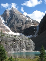
The Canadian Rockies have numerous high peaks and ranges, such as Mount Robson
(3954 metres (12,972.4 ft)) and Mount Columbia (3747 metres (12,293.3 ft)). The Canadian Rockies are composed of shale and limestone (unlike their American cousins). Much of the range is protected by parks and a World Heritage Site.
. They form part of the American Cordillera
, an essentially continuous sequence of mountain ranges that runs all the way from Alaska to the very tip of South America. The Cordillera in turn are the eastern part of the Pacific Ring of Fire
that runs all the way around the Pacific Ocean
.
The Canadian Rockies are bounded on the east by the Canadian Prairies
, on the west by the Rocky Mountain Trench
, and on the north by the Liard River
. Contrary to popular misconception, the Rockies do not extend north into Yukon
or Alaska
, or west into central British Columbia. North of the Liard River
, the Mackenzie Mountains
, which are a distinct mountain range, form a portion of the border between the Yukon and the Northwest Territories
. The mountain ranges to the west of the Rocky Mountain Trench
in southern British Columbia are called the Columbia Mountains
, and are not considered to be part of the Rockies by Canadian geologists.
(3954 m (12,972.4 ft)) is the highest peak in the Canadian Rockies, but not the highest in British Columbia, since there are some higher mountains in the Coast Mountains
and Saint Elias Range. However, Mount Robson is particularly impressive because it stands out on the continental divide
towering over Yellowhead Pass
, one of the lowest passes in the Canadian Rockies, and is close to the Yellowhead Highway
. Its base is only 985 m above sea level, meaning it has a total vertical relief of 2,969 m or nearly 10,000 feet. In addition, it rises the 3 km to its summit in a distance of only 4 km from its base at Kinney Lake. Climbing Mount Robson is a challenge suitable for experienced and well-prepared mountaineers, and usually requires a week on the mountain.
Mount Columbia
(3747 m (12,293.3 ft)) is the second-highest peak in the Canadian Rockies, and is the highest mountain in Alberta. There is a non-technical route to the top involving only kicking steps in the snow, but the approach is across the Columbia Icefield
and requires glacier travel and crevasse rescue knowledge. It is normally done in two days, with a night at high camp, but some strong skiers have done from the highway in a day. On the other hand, many others have been stuck in their tents for days waiting for the weather to clear. From the same high camp as for Mount Columbia, it is possible to ascend a number of other high peaks in the area, including North Twin, South Twin, Kitchener, Stutfield and Snow Dome.
Snow Dome
(3456 m (11,338.6 ft)) is not an impressive peak by Rockies standards, but it has the distinction of being the hydrological apex of North America. Water flows off Snow Dome into three different watersheds, into the Pacific Ocean
, Arctic Ocean
, and Atlantic Ocean
via Hudson Bay
. It is the easiest and most popular ascent on the Columbia Icefield, a gentle ski to the top from Columbia high camp, but glacier travel is required
Of the highest peaks, only Mount Temple (3543 m (11,624 ft)) has an established scrambling route. All other mountains (including other routes up Mount Temple), require more mountaineering
skills and experience. Despite the fact that it is only a moderate scramble, even Mount Temple should not be attempted by novices. According to the Alpine Club of Canada
, more people have died on Mount Temple than any other Canadian mountain, including seven youths in an unsupervised American school group in 1955. The upper slopes are usually covered with snow and there is a glacier on top. Scramblers on Mount Temple should carry an ice axe and enough clothing to survive a freezing night on the mountain if a storm hits and prevents them from descending.
Contrary to popular misconception, the Canadian Rockies are not the highest mountain ranges in Canada. Both the Saint Elias Mountains
(highest point in Canada Mount Logan
at 5,959 metres) and the Coast Mountains
(highest point Mount Waddington
at 4,016 metres) have higher summits.
s, structured in two main groupings, the Continental Ranges
, which has three main subdivisions, the Front Range
, Park Ranges
and Kootenay Ranges
, and the Northern Rockies which comprise two main groupings, the Hart Ranges
and the Muskwa Ranges
. The division-point of the two main groupings is at Monkman Pass
northwest of Mount Robson
and to the southwest of Mount Ovington.
such as limestone
and shale
, whereas the American Rockies are made mostly of metamorphic
and igneous rock
such as gneiss
and granite
. The American Rockies are, on average, higher in elevation than the Canadian Rockies, but have less vertical relief, which is to say they are shorter from base to summit because the mountain valleys are higher.
The Canadian Rockies are more jagged than the American Rockies, because the Canadian Rockies have been very heavily glaciated, resulting in sharply pointed mountains separated by wide, U-shaped valleys gouged by glaciers, whereas the American Rockies are more rounded, with river-carved V-shaped valleys between them. The Canadian Rockies are cooler and wetter, giving them moister soil, bigger rivers, and more glaciers. The tree line is much lower in the Canadian Rockies than in the American Rockies.
 Five national parks are located within the Canadian Rockies, four of which interlock and make up the Canadian Rocky Mountain Parks
World Heritage site. These four parks are Banff
, Jasper
, Kootenay
and Yoho
. The national park not included in the World Heritage Site is Waterton
, which does not interlock with the others (it lies farther south, along the international boundary). The World Heritage site also includes three British Columbia provincial parks that adjoin the four national parks: Hamber
, Mount Assiniboine
and Mount Robson
. Together, all these national and provincial parks were declared a single UNESCO
World Heritage Site
in 1984 for the unique mountain landscapes found there, comprising peaks, glacier
s, lakes, waterfalls, canyon
s and limestone caves as well as fossil
s (e.g. the Burgess Shale
, once a World Heritage Site in its own right, is now part of the Canadian Rocky Mountain Parks World Heritage Site). Numerous other provincial parks are located in the Canadian Rockies.
Throughout the Rockies, and especially in the national parks, the Alpine Club of Canada
maintains a series of alpine huts for use by mountaineers
and adventurers.
was founded to provide a link from the province of British Columbia to the eastern provinces. The main difficulty in providing such a link were the Rockies themselves: treacherous mountain passes, fast rivers and sheer drops made for a difficult railway construction process. The following articles describe in detail the political and technical feats involved:
Canada
Canada is a North American country consisting of ten provinces and three territories. Located in the northern part of the continent, it extends from the Atlantic Ocean in the east to the Pacific Ocean in the west, and northward into the Arctic Ocean...
segment of the North America
North America
North America is a continent wholly within the Northern Hemisphere and almost wholly within the Western Hemisphere. It is also considered a northern subcontinent of the Americas...
n Rocky Mountains
Rocky Mountains
The Rocky Mountains are a major mountain range in western North America. The Rocky Mountains stretch more than from the northernmost part of British Columbia, in western Canada, to New Mexico, in the southwestern United States...
range
Mountain range
A mountain range is a single, large mass consisting of a succession of mountains or narrowly spaced mountain ridges, with or without peaks, closely related in position, direction, formation, and age; a component part of a mountain system or of a mountain chain...
. They are the eastern part of the Canadian Cordillera, extending from the Interior Plains
Interior Plains
The Interior Plains is a vast physiographic region that spreads across the Laurentian craton of central North America.-Geography:The Interior Plains are an extensive physiographic division encompassing 8 distinct physiographic provinces, the Interior Low Plateaus, Great Plains, Central Lowland,...
of Alberta to the Rocky Mountain Trench
Rocky Mountain Trench
The Rocky Mountain Trench, or the Trench or The Valley of a Thousand Peaks, is a large valley in the northern part of the Rocky Mountains. It is both visually and cartographically a striking physiographic feature extending approximately from Flathead Lake, Montana, to the Liard River, just south...
of British Columbia. The southern end borders Idaho
Idaho
Idaho is a state in the Rocky Mountain area of the United States. The state's largest city and capital is Boise. Residents are called "Idahoans". Idaho was admitted to the Union on July 3, 1890, as the 43rd state....
and Montana
Montana
Montana is a state in the Western United States. The western third of Montana contains numerous mountain ranges. Smaller, "island ranges" are found in the central third of the state, for a total of 77 named ranges of the Rocky Mountains. This geographical fact is reflected in the state's name,...
of the USA
United States
The United States of America is a federal constitutional republic comprising fifty states and a federal district...
. The northern end is at the Liard River
Liard River
The Liard River flows through Yukon, British Columbia and the Northwest Territories, Canada. Rising in the Saint Cyr Range of the Pelly Mountains in southeastern Yukon, it flows southeast through British Columbia, marking the northern end of the Rocky Mountains and then curving northeast back...
in northern British Columbia
British Columbia
British Columbia is the westernmost of Canada's provinces and is known for its natural beauty, as reflected in its Latin motto, Splendor sine occasu . Its name was chosen by Queen Victoria in 1858...
.
The Canadian Rockies have numerous high peaks and ranges, such as Mount Robson
Mount Robson
Mount Robson is the most prominent mountain in North America's Rocky Mountain range; it is also the highest point in the Canadian Rockies. The mountain is located entirely within Mount Robson Provincial Park of British Columbia, and is part of the Rainbow Range. It is commonly thought to be the...
(3954 metres (12,972.4 ft)) and Mount Columbia (3747 metres (12,293.3 ft)). The Canadian Rockies are composed of shale and limestone (unlike their American cousins). Much of the range is protected by parks and a World Heritage Site.
Geography
The Canadian Rockies are the easternmost part of the Canadian Cordillera, the collective name for the mountains of Western CanadaWestern Canada
Western Canada, also referred to as the Western provinces and commonly as the West, is a region of Canada that includes the four provinces west of the province of Ontario.- Provinces :...
. They form part of the American Cordillera
American cordillera
The American Cordillera is a cordillera that consists of an essentially continuous sequence of mountain ranges that form the western "backbone" of North America, Central America, South America and Antarctica. From north to south, this sequence of overlapping and parallel ranges begins with the...
, an essentially continuous sequence of mountain ranges that runs all the way from Alaska to the very tip of South America. The Cordillera in turn are the eastern part of the Pacific Ring of Fire
Pacific Ring of Fire
The Pacific Ring of Fire is an area where large numbers of earthquakes and volcanic eruptions occur in the basin of the Pacific Ocean. In a horseshoe shape, it is associated with a nearly continuous series of oceanic trenches, volcanic arcs, and volcanic belts and/or plate movements...
that runs all the way around the Pacific Ocean
Pacific Ocean
The Pacific Ocean is the largest of the Earth's oceanic divisions. It extends from the Arctic in the north to the Southern Ocean in the south, bounded by Asia and Australia in the west, and the Americas in the east.At 165.2 million square kilometres in area, this largest division of the World...
.
The Canadian Rockies are bounded on the east by the Canadian Prairies
Canadian Prairies
The Canadian Prairies is a region of Canada, specifically in western Canada, which may correspond to several different definitions, natural or political. Notably, the Prairie provinces or simply the Prairies comprise the provinces of Alberta, Saskatchewan, and Manitoba, as they are largely covered...
, on the west by the Rocky Mountain Trench
Rocky Mountain Trench
The Rocky Mountain Trench, or the Trench or The Valley of a Thousand Peaks, is a large valley in the northern part of the Rocky Mountains. It is both visually and cartographically a striking physiographic feature extending approximately from Flathead Lake, Montana, to the Liard River, just south...
, and on the north by the Liard River
Liard River
The Liard River flows through Yukon, British Columbia and the Northwest Territories, Canada. Rising in the Saint Cyr Range of the Pelly Mountains in southeastern Yukon, it flows southeast through British Columbia, marking the northern end of the Rocky Mountains and then curving northeast back...
. Contrary to popular misconception, the Rockies do not extend north into Yukon
Yukon
Yukon is the westernmost and smallest of Canada's three federal territories. It was named after the Yukon River. The word Yukon means "Great River" in Gwich’in....
or Alaska
Alaska
Alaska is the largest state in the United States by area. It is situated in the northwest extremity of the North American continent, with Canada to the east, the Arctic Ocean to the north, and the Pacific Ocean to the west and south, with Russia further west across the Bering Strait...
, or west into central British Columbia. North of the Liard River
Liard River
The Liard River flows through Yukon, British Columbia and the Northwest Territories, Canada. Rising in the Saint Cyr Range of the Pelly Mountains in southeastern Yukon, it flows southeast through British Columbia, marking the northern end of the Rocky Mountains and then curving northeast back...
, the Mackenzie Mountains
Mackenzie Mountains
The Mackenzie Mountains are a mountain range forming part of the Yukon-Northwest Territories boundary between the Liard and Peel rivers. The range is named in honour of Canada's second Prime Minister Alexander Mackenzie. Nahanni National Park Reserve is in the Mackenzie Mountains.The Mackenzie...
, which are a distinct mountain range, form a portion of the border between the Yukon and the Northwest Territories
Northwest Territories
The Northwest Territories is a federal territory of Canada.Located in northern Canada, the territory borders Canada's two other territories, Yukon to the west and Nunavut to the east, and three provinces: British Columbia to the southwest, and Alberta and Saskatchewan to the south...
. The mountain ranges to the west of the Rocky Mountain Trench
Rocky Mountain Trench
The Rocky Mountain Trench, or the Trench or The Valley of a Thousand Peaks, is a large valley in the northern part of the Rocky Mountains. It is both visually and cartographically a striking physiographic feature extending approximately from Flathead Lake, Montana, to the Liard River, just south...
in southern British Columbia are called the Columbia Mountains
Columbia Mountains
The Columbia Mountains are a group of mountain ranges located in southeastern British Columbia, and partially in Montana, Idaho and Washington. The mountain range covers 135,952 km² . The range is bounded by the Rocky Mountain Trench on the east, and the Kootenay River on the south; their...
, and are not considered to be part of the Rockies by Canadian geologists.
Highest peaks
Mount RobsonMount Robson
Mount Robson is the most prominent mountain in North America's Rocky Mountain range; it is also the highest point in the Canadian Rockies. The mountain is located entirely within Mount Robson Provincial Park of British Columbia, and is part of the Rainbow Range. It is commonly thought to be the...
(3954 m (12,972.4 ft)) is the highest peak in the Canadian Rockies, but not the highest in British Columbia, since there are some higher mountains in the Coast Mountains
Coast Mountains
The Coast Mountains are a major mountain range, in the Pacific Coast Ranges, of western North America, extending from southwestern Yukon through the Alaska Panhandle and virtually all of the Coast of British Columbia. They are so-named because of their proximity to the sea coast, and are often...
and Saint Elias Range. However, Mount Robson is particularly impressive because it stands out on the continental divide
Continental divide
A continental divide is a drainage divide on a continent such that the drainage basin on one side of the divide feeds into one ocean or sea, and the basin on the other side either feeds into a different ocean or sea, or else is endorheic, not connected to the open sea...
towering over Yellowhead Pass
Yellowhead Pass
The Yellowhead Pass is a mountain pass across the Continental Divide of the Canadian Rockies. It is located on the border between the Canadian provinces of Alberta and British Columbia, and lies within Jasper National Park and Mount Robson Provincial Park....
, one of the lowest passes in the Canadian Rockies, and is close to the Yellowhead Highway
Yellowhead Highway
The Yellowhead Highway is a major east-west highway connecting the four western Canadian provinces of British Columbia, Alberta, Saskatchewan, and Manitoba. Although part of the Trans-Canada Highway system, the highway should not be confused with the more southerly, originally-designated...
. Its base is only 985 m above sea level, meaning it has a total vertical relief of 2,969 m or nearly 10,000 feet. In addition, it rises the 3 km to its summit in a distance of only 4 km from its base at Kinney Lake. Climbing Mount Robson is a challenge suitable for experienced and well-prepared mountaineers, and usually requires a week on the mountain.
Mount Columbia
Mount Columbia (Alberta)
Mount Columbia is the highest point in Alberta, Canada and the second highest peak in the Canadian Rockies after Mount Robson. It is located on the border between Alberta and British Columbia on the northern edge of the Columbia Icefield. Its highest point, however, lies within Jasper National Park...
(3747 m (12,293.3 ft)) is the second-highest peak in the Canadian Rockies, and is the highest mountain in Alberta. There is a non-technical route to the top involving only kicking steps in the snow, but the approach is across the Columbia Icefield
Columbia Icefield
The Columbia Icefield is an icefield located in the Canadian Rockies, astride the Continental Divide of North America. The icefield lies partly in the northwestern tip of Banff National Park and the southern end of Jasper National Park. It is about 325 km² in area, 100 to 365 metres in depth and...
and requires glacier travel and crevasse rescue knowledge. It is normally done in two days, with a night at high camp, but some strong skiers have done from the highway in a day. On the other hand, many others have been stuck in their tents for days waiting for the weather to clear. From the same high camp as for Mount Columbia, it is possible to ascend a number of other high peaks in the area, including North Twin, South Twin, Kitchener, Stutfield and Snow Dome.
Snow Dome
Snow Dome (Canada)
Snow Dome is a mountain located on the Continental Divide in the Columbia Icefield, at the intersection of Banff National Park, and Jasper National Park, on the Alberta and British Columbia border in Canada.The mountain was named in 1898 by J...
(3456 m (11,338.6 ft)) is not an impressive peak by Rockies standards, but it has the distinction of being the hydrological apex of North America. Water flows off Snow Dome into three different watersheds, into the Pacific Ocean
Pacific Ocean
The Pacific Ocean is the largest of the Earth's oceanic divisions. It extends from the Arctic in the north to the Southern Ocean in the south, bounded by Asia and Australia in the west, and the Americas in the east.At 165.2 million square kilometres in area, this largest division of the World...
, Arctic Ocean
Arctic Ocean
The Arctic Ocean, located in the Northern Hemisphere and mostly in the Arctic north polar region, is the smallest and shallowest of the world's five major oceanic divisions...
, and Atlantic Ocean
Atlantic Ocean
The Atlantic Ocean is the second-largest of the world's oceanic divisions. With a total area of about , it covers approximately 20% of the Earth's surface and about 26% of its water surface area...
via Hudson Bay
Hudson Bay
Hudson Bay , sometimes called Hudson's Bay, is a large body of saltwater in northeastern Canada. It drains a very large area, about , that includes parts of Ontario, Quebec, Saskatchewan, Alberta, most of Manitoba, southeastern Nunavut, as well as parts of North Dakota, South Dakota, Minnesota,...
. It is the easiest and most popular ascent on the Columbia Icefield, a gentle ski to the top from Columbia high camp, but glacier travel is required
Of the highest peaks, only Mount Temple (3543 m (11,624 ft)) has an established scrambling route. All other mountains (including other routes up Mount Temple), require more mountaineering
Mountaineering
Mountaineering or mountain climbing is the sport, hobby or profession of hiking, skiing, and climbing mountains. While mountaineering began as attempts to reach the highest point of unclimbed mountains it has branched into specialisations that address different aspects of the mountain and consists...
skills and experience. Despite the fact that it is only a moderate scramble, even Mount Temple should not be attempted by novices. According to the Alpine Club of Canada
Alpine Club of Canada
The Alpine Club of Canada is a mountain club with a National Office in Canmore, Alberta that has been a focal point for Canadian mountaineering since its founding in 1906. The club was co-founded by Arthur Oliver Wheeler, who served as its first president, and Elizabeth Parker, a journalist for...
, more people have died on Mount Temple than any other Canadian mountain, including seven youths in an unsupervised American school group in 1955. The upper slopes are usually covered with snow and there is a glacier on top. Scramblers on Mount Temple should carry an ice axe and enough clothing to survive a freezing night on the mountain if a storm hits and prevents them from descending.
Contrary to popular misconception, the Canadian Rockies are not the highest mountain ranges in Canada. Both the Saint Elias Mountains
Saint Elias Mountains
The Saint Elias Mountains are a subgroup of the Pacific Coast Ranges, located in southeastern Alaska in the United States, southwestern Yukon and the very far northwestern part of British Columbia in Canada. The range spans Wrangell-St. Elias National Park and Preserve in the USA and Kluane...
(highest point in Canada Mount Logan
Mount Logan
Mount Logan is the highest mountain in Canada and the second-highest peak in North America, after Mount McKinley . The mountain was named after Sir William Edmond Logan, a Canadian geologist and founder of the Geological Survey of Canada . Mount Logan is located within Kluane National Park and...
at 5,959 metres) and the Coast Mountains
Coast Mountains
The Coast Mountains are a major mountain range, in the Pacific Coast Ranges, of western North America, extending from southwestern Yukon through the Alaska Panhandle and virtually all of the Coast of British Columbia. They are so-named because of their proximity to the sea coast, and are often...
(highest point Mount Waddington
Mount Waddington
Mount Waddington, once known as Mystery Mountain, is the highest peak in the Coast Mountains of British Columbia, Canada. Although Mount Fairweather and Mount Quincy Adams, which straddle the US border between Alaska and British Columbia are taller, Mount Waddington is the highest peak that lies...
at 4,016 metres) have higher summits.
Mountain ranges
The Canadian Rockies are subdivided into numerous mountain rangeMountain range
A mountain range is a single, large mass consisting of a succession of mountains or narrowly spaced mountain ridges, with or without peaks, closely related in position, direction, formation, and age; a component part of a mountain system or of a mountain chain...
s, structured in two main groupings, the Continental Ranges
Continental Ranges
The Continental Ranges is a name for a major grouping of mountain ranges in the Rocky Mountains located in eastern British Columbia and western Alberta...
, which has three main subdivisions, the Front Range
Front Range
The Front Range is a mountain range of the Southern Rocky Mountains of North America located in the north-central portion of the U.S. State of Colorado and southeastern portion of the U.S. State of Wyoming. It is the first mountain range encountered moving west along the 40th parallel north across...
, Park Ranges
Park Ranges
The Park Ranges, also known as the Main Ranges, are a group of mountain ranges in the Canadian Rockies of eastern British Columbia and western Alberta, Canada...
and Kootenay Ranges
Kootenay Ranges
The Kootenay Ranges, also known as the Western Ranges, are one of the three main subdivisions of the Continental Ranges which comprise the southern half of the Canadian Rockies, the other two subdivisions being the Front Ranges and the Park Ranges...
, and the Northern Rockies which comprise two main groupings, the Hart Ranges
Hart Ranges
The Hart Ranges are one of the main geographic subdivisions of the Canadian Rockies and are the main part of the area that is meant by the Northern Rockies, although the much larger Muskwa Ranges to the north are more deserving of that term — but also much more inaccessible and much less...
and the Muskwa Ranges
Muskwa Ranges
The Muskwa Ranges are a group of mountain ranges in northern British Columbia, Canada. They are part of the Northern Rockies section of the Rocky Mountains and are bounded on their west by the Rocky Mountain Trench and on their east by the Rocky Mountain Foothills...
. The division-point of the two main groupings is at Monkman Pass
Monkman Pass
Monkman Pass, 1061 m , is a mountain pass in the Canadian Rockies, located southwest of the coal-mining town of Tumbler Ridge, British Columbia...
northwest of Mount Robson
Mount Robson
Mount Robson is the most prominent mountain in North America's Rocky Mountain range; it is also the highest point in the Canadian Rockies. The mountain is located entirely within Mount Robson Provincial Park of British Columbia, and is part of the Rainbow Range. It is commonly thought to be the...
and to the southwest of Mount Ovington.
Geology
The Canadian Rockies are quite different in appearance and geology from the American Rockies to the south of them. The Canadian Rockies are composed of layered sedimentary rockSedimentary rock
Sedimentary rock are types of rock that are formed by the deposition of material at the Earth's surface and within bodies of water. Sedimentation is the collective name for processes that cause mineral and/or organic particles to settle and accumulate or minerals to precipitate from a solution....
such as limestone
Limestone
Limestone is a sedimentary rock composed largely of the minerals calcite and aragonite, which are different crystal forms of calcium carbonate . Many limestones are composed from skeletal fragments of marine organisms such as coral or foraminifera....
and shale
Shale
Shale is a fine-grained, clastic sedimentary rock composed of mud that is a mix of flakes of clay minerals and tiny fragments of other minerals, especially quartz and calcite. The ratio of clay to other minerals is variable. Shale is characterized by breaks along thin laminae or parallel layering...
, whereas the American Rockies are made mostly of metamorphic
Metamorphic rock
Metamorphic rock is the transformation of an existing rock type, the protolith, in a process called metamorphism, which means "change in form". The protolith is subjected to heat and pressure causing profound physical and/or chemical change...
and igneous rock
Igneous rock
Igneous rock is one of the three main rock types, the others being sedimentary and metamorphic rock. Igneous rock is formed through the cooling and solidification of magma or lava...
such as gneiss
Gneiss
Gneiss is a common and widely distributed type of rock formed by high-grade regional metamorphic processes from pre-existing formations that were originally either igneous or sedimentary rocks.-Etymology:...
and granite
Granite
Granite is a common and widely occurring type of intrusive, felsic, igneous rock. Granite usually has a medium- to coarse-grained texture. Occasionally some individual crystals are larger than the groundmass, in which case the texture is known as porphyritic. A granitic rock with a porphyritic...
. The American Rockies are, on average, higher in elevation than the Canadian Rockies, but have less vertical relief, which is to say they are shorter from base to summit because the mountain valleys are higher.
The Canadian Rockies are more jagged than the American Rockies, because the Canadian Rockies have been very heavily glaciated, resulting in sharply pointed mountains separated by wide, U-shaped valleys gouged by glaciers, whereas the American Rockies are more rounded, with river-carved V-shaped valleys between them. The Canadian Rockies are cooler and wetter, giving them moister soil, bigger rivers, and more glaciers. The tree line is much lower in the Canadian Rockies than in the American Rockies.
Parks
Canadian Rocky Mountain Parks
The Canadian Rocky Mountain Parks World Heritage Site is located in the Canadian Rockies. It consists of four national parks:*Banff*Jasper*Kootenay*Yohoand three British Columbia provincial parks:*Hamber Provincial Park...
World Heritage site. These four parks are Banff
Banff National Park
Banff National Park is Canada's oldest national park, established in 1885 in the Rocky Mountains. The park, located 110–180 kilometres west of Calgary in the province of Alberta, encompasses of mountainous terrain, with numerous glaciers and ice fields, dense coniferous forest, and alpine...
, Jasper
Jasper National Park
Jasper National Park is the largest national park in the Canadian Rockies, spanning 10,878 km² . It is located in the province of Alberta, north of Banff National Park and west of the City of Edmonton. The park includes the glaciers of the Columbia Icefield, hot springs, lakes, waterfalls and...
, Kootenay
Kootenay National Park
Kootenay National Park is located in southeastern British Columbia Canada covering in the Canadian Rockies and forms part of a World Heritage Site. The park ranges in elevation from at the south-west park entrance to at Deltaform Mountain...
and Yoho
Yoho National Park
Yoho National Park is located in the Canadian Rocky Mountains along the western slope of the Continental Divide in southeastern British Columbia. Yoho NP is bordered by Kootenay National Park on the southern side and Banff National Park on the eastern side...
. The national park not included in the World Heritage Site is Waterton
Waterton Lakes National Park
Waterton Lakes National Park is a national park located in the southwest corner of Alberta, Canada, and borders Glacier National Park in Montana, USA. Waterton was Canada's fourth national park, formed in 1895 and named after Waterton Lake, in turn after the Victorian naturalist and conservationist...
, which does not interlock with the others (it lies farther south, along the international boundary). The World Heritage site also includes three British Columbia provincial parks that adjoin the four national parks: Hamber
Hamber Provincial Park
Hamber Provincial Park is a provincial park in British Columbia, Canada, located at the provincial border with Alberta, surrounded on three sides by Jasper National Park.-History:The park was named in honour of Eric W...
, Mount Assiniboine
Mount Assiniboine Provincial Park
Mount Assiniboine Provincial Park is a provincial park in British Columbia, Canada, located around Mount Assiniboine.-History:The park was established 1922...
and Mount Robson
Mount Robson Provincial Park
Mount Robson Provincial Park is a large provincial park in the Canadian Rockies with an area of 2,249 km². The park is located entirely within British Columbia, bordering Jasper National Park in Alberta. The B.C. legislature created the park in 1913, the same year as the first ascent of Mount...
. Together, all these national and provincial parks were declared a single UNESCO
UNESCO
The United Nations Educational, Scientific and Cultural Organization is a specialized agency of the United Nations...
World Heritage Site
World Heritage Site
A UNESCO World Heritage Site is a place that is listed by the UNESCO as of special cultural or physical significance...
in 1984 for the unique mountain landscapes found there, comprising peaks, glacier
Glacier
A glacier is a large persistent body of ice that forms where the accumulation of snow exceeds its ablation over many years, often centuries. At least 0.1 km² in area and 50 m thick, but often much larger, a glacier slowly deforms and flows due to stresses induced by its weight...
s, lakes, waterfalls, canyon
Canyon
A canyon or gorge is a deep ravine between cliffs often carved from the landscape by a river. Rivers have a natural tendency to reach a baseline elevation, which is the same elevation as the body of water it will eventually drain into. This forms a canyon. Most canyons were formed by a process of...
s and limestone caves as well as fossil
Fossil
Fossils are the preserved remains or traces of animals , plants, and other organisms from the remote past...
s (e.g. the Burgess Shale
Burgess Shale
The Burgess Shale Formation, located in the Canadian Rockies of British Columbia, is one of the world's most celebrated fossil fields, and the best of its kind. It is famous for the exceptional preservation of the soft parts of its fossils...
, once a World Heritage Site in its own right, is now part of the Canadian Rocky Mountain Parks World Heritage Site). Numerous other provincial parks are located in the Canadian Rockies.
Throughout the Rockies, and especially in the national parks, the Alpine Club of Canada
Alpine Club of Canada
The Alpine Club of Canada is a mountain club with a National Office in Canmore, Alberta that has been a focal point for Canadian mountaineering since its founding in 1906. The club was co-founded by Arthur Oliver Wheeler, who served as its first president, and Elizabeth Parker, a journalist for...
maintains a series of alpine huts for use by mountaineers
Mountaineering
Mountaineering or mountain climbing is the sport, hobby or profession of hiking, skiing, and climbing mountains. While mountaineering began as attempts to reach the highest point of unclimbed mountains it has branched into specialisations that address different aspects of the mountain and consists...
and adventurers.
The Rockies and The Canadian Pacific Railway
The Canadian Pacific RailwayCanadian Pacific Railway
The Canadian Pacific Railway , formerly also known as CP Rail between 1968 and 1996, is a historic Canadian Class I railway founded in 1881 and now operated by Canadian Pacific Railway Limited, which began operations as legal owner in a corporate restructuring in 2001...
was founded to provide a link from the province of British Columbia to the eastern provinces. The main difficulty in providing such a link were the Rockies themselves: treacherous mountain passes, fast rivers and sheer drops made for a difficult railway construction process. The following articles describe in detail the political and technical feats involved:
- Canadian Pacific SurveyCanadian Pacific SurveyThe Canadian Pacific Survey or Canadian Pacific Railway Survey consisted of a large number of distinct geographical surveys conducted during the 1870s and 1880s designed to determine the ideal route of the Canadian Pacific Railway...
- Big HillBig HillThe Big Hill on the Canadian Pacific Railway main line in British Columbia, Canada, was the most difficult piece of railway track on the Canadian Pacific Railway's route. It was situated in the rugged Canadian Rockies west of the Continental Divide and Kicking Horse Pass...
- Field HillField HillField Hill is a steep portion of the mainline of the Canadian Pacific Railway located near Field, British Columbia. Field was created solely to accommodate the Canadian Pacific Railway's need for additional locomotives to be added to trains about to tackle both Field Hill, and the Big Hill. Here a...
- Kicking Horse PassKicking Horse PassKicking Horse Pass is a high mountain pass across the Continental Divide of the Americas of the Canadian Rockies on the Alberta/British Columbia border, and lying within Yoho and Banff National Parks...
- Spiral Tunnels
See also
- Ecology of the Rocky MountainsEcology of the Rocky MountainsThe ecology of the Rocky Mountains is diverse, due to the effects of a variety of environmental factors. The Rocky Mountains are the major mountain range in western North America, running from the far north of British Columbia in Canada to New Mexico in the southwestern United States, climbing from...
- Arctic CordilleraArctic CordilleraThe Arctic Cordillera is a vast, deeply dissected chain of mountain ranges extending along the northeastern flank of the Canadian Arctic Archipelago from Ellesmere Island to the northeasternmost part of the Labrador Peninsula in northern Labrador and northern Quebec, Canada...
- an example of another major mountain system in North America east of the Canadian Rockies. - The Rocky Mountain RangersThe Rocky Mountain RangersThe Rocky Mountain Rangers is a Primary Reserve infantry regiment of the Canadian Forces. The regimental headquarters are located at JR Vicars Armoury in Kamloops, British Columbia...