
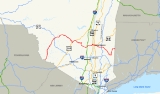
New York State Route 55
Encyclopedia
New York State Route 55 (NY 55) is a state highway in southern New York, running from the Pennsylvania state line
at the Delaware River
in Barryville
to the Connecticut
state line at Wingdale. It is the only other state highway beside NY 7
to completely cross the state, from border to border, in an east–west direction, although NY 17
does so and is partially east–west. It also forms a concurrency
when it joins US 44
for 33 miles (53 km).
Together with NY 52
, which it closely parallels and briefly joins
in downtown Liberty
, it forms the latitudinal backbone of the Hudson Valley
region for non-interstate traffic. It offers the traveler a wide variety of landscapes, from farmlands, mountains and forests to the urban center of Poughkeepsie
. Sights along the way include two of New York City
's major reservoirs in the Catskills
, a dramatic crossing of the Shawangunk Ridge
, and the Mid-Hudson Bridge
.
at an intersection with the river-paralleling NY 97
in the hamlet of Barryville
. However, the right-of-way of NY 55 continues southwest of the junction on the Barryville–Shohola Bridge
over the Delaware Bridge to the Pennsylvania state line, where it connects to Pennsylvania Route 434 in Shohola
. From Barryville, it heads mostly due north, despite its east–west signage, through Sullivan County
's heavily wooded southwest corner. Much of NY 55 within the county is county-maintained; as such, it overlaps with and is co-signed with several county routes as it proceeds northeastward. Some NY 55 shields through this stretch were posted by the county and have a small "NY" visible atop the shields, designed after an older state standard.
 After passing Toronto Reservoir, which serves local communities, it finally reaches its next junction NY 17B
, at White Lake
, more than 15 miles (24 km) from its start. NY 55 joins NY 17B eastward for 0.8 miles (1.3 km) around the south end of the lake before returning to its northerly bearing. Once past the lake, it begins to trend more to the northeast, taking it past the Sullivan County International Airport
and through another quiet vacation hamlet, Swan Lake and finally to the village of Liberty
after 11 miles (18 km). Here, it joins NY 52
for two blocks prior to leaving town oriented more directly east and exchanging places with NY 52 as the northern regional trunk route. Access to NY 17
, the future Interstate 86
, was until recently provided via either 52 or another nearby street. In 2000 a limited exit, 100A, was constructed near a state police
barracks to provide direct access from 55 to 17 eastbound. The NY 52 eastern junction in Liberty was rebuilt as a roundabout in 2007.
NY 55 overlaps no less than five different county routes between NY 97 and Liberty. The first, County Route 11 (CR 11), follows NY 55 from its western terminus at NY 97 to CR 32 (Proctor Road) and CR 33 (Eldred–Yulan Road). At this point, CR 11 gives way to CR 12, which runs north on NY 55 to CR 26 (Crystal Lake Road). The designation shifts here to CR 13, which takes up the section of NY 55 from CR 26 to the west end of the NY 17B overlap, which is state-maintained. When NY 55 leaves NY 17B, it becomes conjoined with CR 14, NY 55's county designation to CR 74 (West Mongaup Road) in Swan Lake. The last section of NY 55 between CR 74 and the Liberty village line is co-designated as CR 15. Each county route has an associated road name; they are Brook Road, Board Road, White Lake Road, Swan Lake Road, and Liberty Road, respectively.
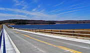
 Beyond Liberty, NY 55 enters a less populous region of the county. The route, known as Neversink Road and co-designated as CR 16, climbs toward Neversink Reservoir
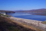
. At Aden Road, CR 16 ends and NY 55 becomes state-maintained once again as it proceeds to the reservoir, where it becomes the only state highway to run across the top of a New York City watershed dam. Descending from this, NY 55 meets Wilson Shields Road, where county maintenance returns in the form of CR 17. Both NY 55 and CR 17 cross the Blue Line
into Catskill Park, where maintenance of the route changes for one final time in Sullivan County at Wagners Road. Here, CR 17 terminates and NY 55 progresses onward as a state-maintained highway.
Shortly after this point, CR 19 intersects from the north. This route was once the middle segment of NY 42
, and indeed reassurance shields for NY 42 can be seen along NY 55 immediately following the junction. Additionally, its reference marker
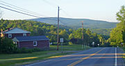
s displace those of NY 55 alongside the road. In the next settlement of consequence, the hamlet of Grahamsville
, 13 miles (21 km) east of Liberty, the current southern segment of NY 42 intersects from the south and the signage returns to NY 55.
Immediately upon taking leave of Grahamsville and passing through the Grahamsville Historic District
, then by Tri-Valley Central School
, the road drops slightly and Rondout Reservoir
recedes into the distance ahead. NY 55A
splits off to follow the northern shore, while 55 remains along the south side, crossing into Ulster County
. Over the next 9 miles (14.4 km) until 55A rejoins, there are many beautiful views of the reservoir available from alongside the road.
Shortly after Merriman Dam at Rondout's east end, the two roads descend and rejoin near the southern tip of Catskill Park. 55 slowly descends and bends to a more southeasterly route as it winds 5 miles (9 km) alongside Rondout Creek
to the hamlet of Napanoch
, where it joins US 209 in its due northeast course up the Rondout Valley.
 At the Valero-branded station just south of Kerhonkson
, 4 miles (6.4 km) north of Napanoch, NY 55 turns eastward once again, as US 44
begins. The two highways, which will remain joined for long enough that they are known locally by both numbers, immediately begin a gentle climb into the Shawangunks
(known colloquially as the "Gunks"), crossing the aqua blazes of the Long Path
hiking trail as they do so.
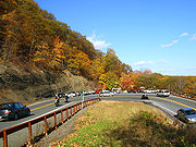
Two miles further on, a wide open section bordered by just a stone wall
on one side offers a sweeping panorama to the northwest, taking in much of the Catskills. Slide Mountain
, the highest peak in the range, can be seen amid the lower peaks around it, and more to the north the Devil's Path
in Greene County
is visible in all its splendor. This section takes up an entire mile, with parking areas available at either end for those drivers who wish to stop and take it in.
The highway continues on through the scrubby forests and rock outcrops that characterize the northern Shawangunks. A mile of winding past trailheads and woods brings on the main entrance to the first of two highly popular recreation spots in this area, Minnewaska State Park Preserve
, which features many miles of hiking trails, picnic
grounds and a popular glacial lake
. The forests alongside the highway grow a bit taller as it passes several scenic waterfall
s, where cars often defy local parking regulations so their occupants can stop and look, as it descends to reach the parking areas for the Mohonk Preserve
roughly another mile past Minnewaska.
Here, at the eastern edge of the Gunks, are located the white cliffs that have long attracted climbers
to Mohonk, and many of them are likely to be parked here on good days. Another parking area allows views of not only these cliffs but the sprawling central Hudson Valley below.
 Immediately afterward the road bends and descends somewhat steeply into an extremely tight hairpin turn
, where the posted speed limit
drops to 5 miles (10 km) per hour. So notorious is this turn local lore has it (falsely) that it was the site of Bob Dylan
's serious 1966 motorcycle
accident.
departs eastward, towards New Paltz
. US 44/NY 55 continues southward, gradually returning to its eastward heading as it drops, crossing the Wallkill River
, passing through quaint Gardiner
and intersecting scenic NY 208
a mile east of the hamlet at a junction known as Ireland Corners.
 Past 208 the road begins to wend and weave through the farms and orchard
s devoted to apple
s in this region of the county, crossing under the New York State Thruway
between the hamlets of Modena
and Ardonia. No direct crossing is available, however access is available farther east via NY 299
. Modena, 6 miles (10 km) from Gardiner, is marked by a traffic light
at the intersection with NY 32
, the major north–south state highway west of the Hudson.
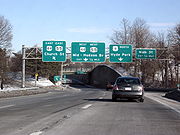
East of Modena, through Clintondale, the road begins to climb once again into the glacial ridge separating this area from the river. At the notch 44–55 passes through, sweeping views are once again possible in good weather over the orchards ahead. A short descent and two more miles brings the highway to Highland
, the small unincorporated community across from Poughkeepsie
. Just past it, 44–55 makes a tricky turn to join US 9W
southbound. A mile-long concurrency past gas stations and fast-food restaurants ends at an overhead ramp to the Mid-Hudson Bridge
's toll plazas.
freeway along the river's edge, and the nearby train station
.
 In the city, where 44–55 forms the main arterial, the routes divide, with one street carrying eastbound traffic and the other westbound. They run sometimes as much as two blocks apart, with what was for many years the city's attempt at a pedestrian mall
(known as the Main Mall
) between them. Only in Poughkeepsie's eastern end, shortly after the NY 376
junction near Vassar College
, does two-way traffic return. Shortly afterwards, 44 and 55 part ways after over 30 miles (48 km).
Prior to the construction of Poughkeepsie's east–west arterial in the 1970s, 44 and 55 went on Church Street from the bridge to its intersection with Main Street, then on Main Street eastward to the outskirts of the city, where it forked into the two separate routes.
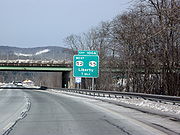
and its interchange with the Taconic State Parkway
just east of Arlington High School
. It continues virtually due east to NY 82
at Billings, where it begins taking a more southeasterly tack.
This takes it to the eastern terminus of NY 216
at Poughquag, then up into the hills of the Town of Beekman
, where the Appalachian Trail
(AT) crosses the road and NY 292
comes to its northern end. Descending once again into the Harlem Valley, 55 reaches NY 22
just south of Pawling
.
Instead of ending at this major north–south route, 55 joins it, heading north for 7 miles (11 km) and crossing the AT once again near the Metro-North flag stop
. At Webutuck, it leaves to the east, winding its way to the Connecticut state line after 3 miles (5 km). It becomes CT 55
, which continues another 2.6 miles (4 km) to its own eastern terminus at US 7
.
from the intersection with County Route 7 west of Gardiner
to U.S. Route 9W (US 9W) follows the Farmers' Turnpike, which was built by the Farmer's Turnpike & Bridge Company, a private company established in March 1808. Its purpose was to allow the transport of agricultural products from the Gardiner area to docks on the Hudson River
at Milton
. The route at that time followed the north end of Albany Post Road (County Route 9) over the Shawangunk Kill
and then east along the kill's south bank to ford
the Wallkill River
just south of the confluence
. The turnpike company eventually went bankrupt.
 In the early 1910s, the state of New York
improved the former turnpike to state highway standards at a cost of just over $172,868 (equivalent to $ in ). The section from the Plattekill–Lloyd
town line north of Ardonia to what is now US 9W was added to the state highway system on September 9, 1911, as State Highway 350 (SH 350) while the portion from modern CR 7 to the west end of SH 350 was accepted into the state highway system on October 20, 1913, as SH 351. Both designations were assigned by the New York State Legislature for inventory purposes and were unsigned
.
In 1908, the legislature created a statewide system of unsigned legislative route
s. No designation was assigned to most of the modern NY 55 corridor; however, the section of highway that NY 55 now shares with NY 22
from Pawling
to Wingdale was designated as part of Route 1, a route extending from New York City
to Albany
. On March 1, 1921, the segment of NY 55 that overlaps with US 209 in Wawarsing
was included in Route 40, a new route that generally followed the modern US 209 corridor between Port Jervis
and Kingston.
 When the first set of posted routes in New York were assigned in 1924, much of legislative Route 1—including from Pawling to Wingdale—was designated as part of NY 22. By 1926, all of legislative Route 40 was designated as NY 50 while a small portion of modern NY 55 between what is now NY 216
and NY 292
near Poughquag was signed as part of NY 39. NY 50 became part of US 6 in 1927. Over the next eight years, the highway went through several designations, becoming US 6N in 1928, NY 279 in 1933 and US 209 ca. 1935.
NY 39 was reassigned to another highway
in western New York
in the 1930 renumbering of state highways in New York. At the same time, NY 55 was assigned to much of its current alignment between Barryville
and Pawling, utilizing the old Farmers' Turnpike in eastern Ulster County and a series of previously unnumbered roads in Sullivan
, western Ulster, and Dutchess
Counties. From Poughquag to West Pawling, NY 55 overlapped with NY 52
, which replaced NY 39 east of East Fishkill
. Initially, NY 55 continued east from Pawling to the Connecticut
state line at Sherman
via Quaker Hill and Kirby Hill Roads.
In the early 1930s, the modern routing of NY 55 between Wingdale and the Connecticut border was designated as NY 341. The alignments of NY 55 and NY 341 east of NY 22 were flipped ca. 1934, placing NY 55 on its current alignment and NY 341 on NY 55's old routing. NY 55 reached Wingdale by way of a 7 miles (11 km) overlap with NY 22. When NY 55 was first assigned, it was routed along the northern bank of Rondout Creek
between the hamlets of Grahamsville
and Lackawack. In the mid-1940s, NY 55 was realigned to follow a new highway along the southern bank while its former routing to the north became NY 55A
. Both changes were made in order to accommodate the Rondout Reservoir
, which was created ca. 1950 following the construction of the Merriman Dam.
 NY 55A
(9.52 miles or 15.32 km) is an alternate route of NY 55 along the north side of the Rondout Reservoir
between Grahamsville
and Napanoch
. It was assigned in the mid-1940s.
New York - Pennsylvania Border
The New York–Pennsylvania border is the state line between the U.S. states of New York and Pennsylvania. It has three sections:* along the center line of the Delaware River from the tri-point with New Jersey at the confluence of the Delaware with the Neversink River in Port Jervis, New York to the...
at the Delaware River
Delaware River
The Delaware River is a major river on the Atlantic coast of the United States.A Dutch expedition led by Henry Hudson in 1609 first mapped the river. The river was christened the South River in the New Netherland colony that followed, in contrast to the North River, as the Hudson River was then...
in Barryville
Barryville, New York
Barryville is a hamlet in Highland, Sullivan County, New York. It is named for William T. Barry, postmaster general under President Andrew Jackson. The community grew up around the D&H Canal, which opened in 1828 and operated until 1898...
to the Connecticut
Connecticut
Connecticut is a state in the New England region of the northeastern United States. It is bordered by Rhode Island to the east, Massachusetts to the north, and the state of New York to the west and the south .Connecticut is named for the Connecticut River, the major U.S. river that approximately...
state line at Wingdale. It is the only other state highway beside NY 7
New York State Route 7
New York State Route 7 is a 180-mile long New York State Highway that runs from the New York/Pennsylvania border south of Binghamton, New York to the New York/Vermont border east of Hoosick. Most of the road runs along the Susquehanna Valley, closely paralleling Interstate 88 throughout...
to completely cross the state, from border to border, in an east–west direction, although NY 17
New York State Route 17
New York State Route 17 is a state highway that extends for through the Southern Tier and Downstate regions of New York in the United States...
does so and is partially east–west. It also forms a concurrency
Concurrency (road)
A concurrency, overlap, or coincidence in a road network is an instance of one physical road bearing two or more different highway, motorway, or other route numbers...
when it joins US 44
U.S. Route 44
U.S. Route 44 is an east–west United States highway that runs for 237 miles through four states in the Northeastern region of the United States. The western terminus is at U.S. Route 209 and New York State Route 55 in Kerhonkson, a hamlet in the Hudson Valley region of New York...
for 33 miles (53 km).
Together with NY 52
New York State Route 52
New York State Route 52 is a long state highway in the southeastern part of New York in the United States. It generally runs from west to east, beginning at the Pennsylvania state line in the Delaware River near Narrowsburg, crossing the Hudson River on the Newburgh-Beacon Bridge, and ending...
, which it closely parallels and briefly joins
Concurrency (road)
A concurrency, overlap, or coincidence in a road network is an instance of one physical road bearing two or more different highway, motorway, or other route numbers...
in downtown Liberty
Liberty (village), New York
Liberty is a village in Sullivan County, New York, United States. The population was 3,975 at the 2000 census.The Village of Liberty is centrally located in the Town of Liberty and is adjacent to New York Route 17.- History :...
, it forms the latitudinal backbone of the Hudson Valley
Hudson Valley
The Hudson Valley comprises the valley of the Hudson River and its adjacent communities in New York State, United States, from northern Westchester County northward to the cities of Albany and Troy.-History:...
region for non-interstate traffic. It offers the traveler a wide variety of landscapes, from farmlands, mountains and forests to the urban center of Poughkeepsie
Poughkeepsie (city), New York
Poughkeepsie is a city in the state of New York, United States, which serves as the county seat of Dutchess County. Poughkeepsie is located in the Hudson River Valley midway between New York City and Albany...
. Sights along the way include two of New York City
New York City
New York is the most populous city in the United States and the center of the New York Metropolitan Area, one of the most populous metropolitan areas in the world. New York exerts a significant impact upon global commerce, finance, media, art, fashion, research, technology, education, and...
's major reservoirs in the Catskills
Catskill Mountains
The Catskill Mountains, an area in New York State northwest of New York City and southwest of Albany, are a mature dissected plateau, an uplifted region that was subsequently eroded into sharp relief. They are an eastward continuation, and the highest representation, of the Allegheny Plateau...
, a dramatic crossing of the Shawangunk Ridge
Shawangunk Ridge
The Shawangunk Ridge , also known as the Shawangunk Mountains or The Gunks, is a ridge of bedrock in Ulster County, Sullivan County and Orange County in the state of New York, extending from the northernmost point of New Jersey to the Catskill Mountains.The ridgetop, which widens considerably at...
, and the Mid-Hudson Bridge
Mid-Hudson Bridge
The Mid-Hudson Bridge is a toll suspension bridge which carries US 44 and NY 55 across the Hudson River between Poughkeepsie and Highland in the state of New York. Governor and local resident Franklin D. Roosevelt and his wife Eleanor attended the opening ceremony on August 25, 1930. The bridge...
.
Delaware River to Liberty
NY 55 begins adjacent to the Delaware RiverDelaware River
The Delaware River is a major river on the Atlantic coast of the United States.A Dutch expedition led by Henry Hudson in 1609 first mapped the river. The river was christened the South River in the New Netherland colony that followed, in contrast to the North River, as the Hudson River was then...
at an intersection with the river-paralleling NY 97
New York State Route 97
New York State Route 97 is a north–south scenic route in southern New York, United States. It runs from U.S. Route 6 and US 209 in Port Jervis to NY 17 in Hancock. Its most famous feature is the Hawk's Nest, a tightly winding section of the road along the Delaware River,...
in the hamlet of Barryville
Barryville, New York
Barryville is a hamlet in Highland, Sullivan County, New York. It is named for William T. Barry, postmaster general under President Andrew Jackson. The community grew up around the D&H Canal, which opened in 1828 and operated until 1898...
. However, the right-of-way of NY 55 continues southwest of the junction on the Barryville–Shohola Bridge
Barryville–Shohola Bridge
The Barryville–Shohola Bridge is the fifth generation of bridges constructed over the Delaware River at the communities of Shohola Township, Pennsylvania and Barryville, New York...
over the Delaware Bridge to the Pennsylvania state line, where it connects to Pennsylvania Route 434 in Shohola
Shohola Township, Pennsylvania
Shohola Township is a township in Pike County, Pennsylvania, United States. The population was 2,475 at the 2010 census.Within Shohola Township there are a number of summer camps, including Lake Owego Camp for Boys and Camp Shohola for Boys.-Geography:...
. From Barryville, it heads mostly due north, despite its east–west signage, through Sullivan County
Sullivan County, New York
Sullivan County is a county located in the U.S. state of New York. As of the 2010 census, the population was 77,547. The county seat is Monticello. The name is in honor of Major General John Sullivan, who was a hero in the American Revolutionary War...
's heavily wooded southwest corner. Much of NY 55 within the county is county-maintained; as such, it overlaps with and is co-signed with several county routes as it proceeds northeastward. Some NY 55 shields through this stretch were posted by the county and have a small "NY" visible atop the shields, designed after an older state standard.
New York State Route 17B
New York State Route 17B is a state highway located entirely within Sullivan County, New York. It connects the hamlet of Callicoon at its western end with the Monticello area in the east .-Route description:From its terminus at NY 97 in the hamlet of Callicoon New York State...
, at White Lake
White Lake, New York
White Lake is an unincorporated hamlet in the town of Bethel, Sullivan County, New York on the southeast shore of a lake of the same name. It was the closest community to the Woodstock Music Festival in 1969....
, more than 15 miles (24 km) from its start. NY 55 joins NY 17B eastward for 0.8 miles (1.3 km) around the south end of the lake before returning to its northerly bearing. Once past the lake, it begins to trend more to the northeast, taking it past the Sullivan County International Airport
Sullivan County International Airport
Sullivan County International Airport is a public airport located in the town of Bethel, six miles northwest of the central business district of the village of Monticello, in Sullivan County, New York, United States...
and through another quiet vacation hamlet, Swan Lake and finally to the village of Liberty
Liberty (village), New York
Liberty is a village in Sullivan County, New York, United States. The population was 3,975 at the 2000 census.The Village of Liberty is centrally located in the Town of Liberty and is adjacent to New York Route 17.- History :...
after 11 miles (18 km). Here, it joins NY 52
New York State Route 52
New York State Route 52 is a long state highway in the southeastern part of New York in the United States. It generally runs from west to east, beginning at the Pennsylvania state line in the Delaware River near Narrowsburg, crossing the Hudson River on the Newburgh-Beacon Bridge, and ending...
for two blocks prior to leaving town oriented more directly east and exchanging places with NY 52 as the northern regional trunk route. Access to NY 17
New York State Route 17
New York State Route 17 is a state highway that extends for through the Southern Tier and Downstate regions of New York in the United States...
, the future Interstate 86
Interstate 86 (east)
Interstate 86 is an Interstate Highway that extends for through northwestern Pennsylvania and southern New York in the United States...
, was until recently provided via either 52 or another nearby street. In 2000 a limited exit, 100A, was constructed near a state police
New York State Police
The New York State Police is the state police force of over 4,600 sworn Troopers for the state of New York. It was established on April 11, 1917 by the New York Legislature, in response to the 1913 murder of a construction foreman named Sam Howell in Westchester County, which at that time did not...
barracks to provide direct access from 55 to 17 eastbound. The NY 52 eastern junction in Liberty was rebuilt as a roundabout in 2007.
NY 55 overlaps no less than five different county routes between NY 97 and Liberty. The first, County Route 11 (CR 11), follows NY 55 from its western terminus at NY 97 to CR 32 (Proctor Road) and CR 33 (Eldred–Yulan Road). At this point, CR 11 gives way to CR 12, which runs north on NY 55 to CR 26 (Crystal Lake Road). The designation shifts here to CR 13, which takes up the section of NY 55 from CR 26 to the west end of the NY 17B overlap, which is state-maintained. When NY 55 leaves NY 17B, it becomes conjoined with CR 14, NY 55's county designation to CR 74 (West Mongaup Road) in Swan Lake. The last section of NY 55 between CR 74 and the Liberty village line is co-designated as CR 15. Each county route has an associated road name; they are Brook Road, Board Road, White Lake Road, Swan Lake Road, and Liberty Road, respectively.
Catskills
Neversink Reservoir
Neversink Reservoir is one of several in the Catskill Mountains that supply water to New York City and other communities along its water supply network. It is located in Sullivan County's Town of Neversink, 75 miles northwest of the city....
. At Aden Road, CR 16 ends and NY 55 becomes state-maintained once again as it proceeds to the reservoir, where it becomes the only state highway to run across the top of a New York City watershed dam. Descending from this, NY 55 meets Wilson Shields Road, where county maintenance returns in the form of CR 17. Both NY 55 and CR 17 cross the Blue Line
Blue Line (New York State)
The Blue Line is the term used in New York state for the boundaries of the Adirondack and Catskill parks, within which can be found the state's Forest Preserve...
into Catskill Park, where maintenance of the route changes for one final time in Sullivan County at Wagners Road. Here, CR 17 terminates and NY 55 progresses onward as a state-maintained highway.
Shortly after this point, CR 19 intersects from the north. This route was once the middle segment of NY 42
New York State Route 42
New York State Route 42 is a north–south, discontinuous state highway in the Catskill Mountains region of New York in the United States. The southernmost of the highway's two segments begins at an intersection with U.S. Route 6 and US 209 in Port Jervis and ends at a junction with...
, and indeed reassurance shields for NY 42 can be seen along NY 55 immediately following the junction. Additionally, its reference marker
Reference marker (New York)
In New York, a reference marker is a small green sign mounted approximately every one-tenth mile on highways maintained by the New York State Department of Transportation. This was initiated in response to the Highway Safety Act of 1966 enacted by Congress, in an effort to monitor traffic and...
s displace those of NY 55 alongside the road. In the next settlement of consequence, the hamlet of Grahamsville
Grahamsville, New York
Grahamsville is an unincorporated hamlet at the junction of NY 42 and 55 in the Town of Neversink, in Sullivan County, New York, USA. It is near the western end of Rondout Reservoir, and is the southernmost community in the Catskill Park...
, 13 miles (21 km) east of Liberty, the current southern segment of NY 42 intersects from the south and the signage returns to NY 55.
Immediately upon taking leave of Grahamsville and passing through the Grahamsville Historic District
Grahamsville Historic District
The Grahamsville Historic District is located along both sides of NY 55 just east of that hamlet in the Town of Neversink in Sullivan County, New York, USA. Its church is across the road from Tri-Valley Central School. In 1979 it was added to the National Register of Historic Places.Five buildings...
, then by Tri-Valley Central School
Tri-Valley Central School
Tri-Valley Central School is located on NY 55, near Rondout Reservoir, east of the hamlet of Grahamsville in the town of Neversink, Sullivan County, New York, USA. It educates students from pre-kindergarten to twelfth grade in the Tri-Valley Central School District, which serves not only the town...
, the road drops slightly and Rondout Reservoir
Rondout Reservoir
Rondout Reservoir is part of New York City's water supply network. It is located 75 miles northwest of the city in the Catskill Mountains, near the southern end of Catskill Park, split between the towns of Wawarsing in Ulster County and Neversink in Sullivan County...
recedes into the distance ahead. NY 55A
New York State Route 55A
New York State Route 55A is a state highway located in Sullivan and Ulster counties. It is a loop route connected to NY 55 at both ends, near Grahamsville in the west and Napanoch in the east...
splits off to follow the northern shore, while 55 remains along the south side, crossing into Ulster County
Ulster County, New York
Ulster County is a county located in the state of New York, USA. It sits in the state's Mid-Hudson Region of the Hudson Valley. As of the 2010 census, the population was 182,493. Recent population estimates completed by the United States Census Bureau for the 12-month period ending July 1 are at...
. Over the next 9 miles (14.4 km) until 55A rejoins, there are many beautiful views of the reservoir available from alongside the road.
Shortly after Merriman Dam at Rondout's east end, the two roads descend and rejoin near the southern tip of Catskill Park. 55 slowly descends and bends to a more southeasterly route as it winds 5 miles (9 km) alongside Rondout Creek
Rondout Creek
Rondout Creek is a tributary of the Hudson River in Ulster and Sullivan counties, New York, USA. It rises on Rocky Mountain in the eastern Catskills, flows south into Rondout Reservoir, part of New York City's water supply network, then into the valley between the Catskills and the Shawangunk...
to the hamlet of Napanoch
Napanoch, New York
Napanoch is a hamlet in Ulster County, New York. It is at the junction of routes 209 and 55. It is on the Shawangunk Ridge National Scenic Byway, and is part of the Hudson River Valley National Heritage Area....
, where it joins US 209 in its due northeast course up the Rondout Valley.
US 44 and Shawangunks
Kerhonkson, New York
Kerhonkson is a hamlet in Ulster County, New York, United States. The population was 1,684 at the 2010 census.Kerhonkson is a small hamlet which, along with Accord, makes up the Town of Rochester on US 209, just south of the town's boundary with the Town of Wawarsing and just north of where US 44...
, 4 miles (6.4 km) north of Napanoch, NY 55 turns eastward once again, as US 44
U.S. Route 44
U.S. Route 44 is an east–west United States highway that runs for 237 miles through four states in the Northeastern region of the United States. The western terminus is at U.S. Route 209 and New York State Route 55 in Kerhonkson, a hamlet in the Hudson Valley region of New York...
begins. The two highways, which will remain joined for long enough that they are known locally by both numbers, immediately begin a gentle climb into the Shawangunks
Shawangunk Ridge
The Shawangunk Ridge , also known as the Shawangunk Mountains or The Gunks, is a ridge of bedrock in Ulster County, Sullivan County and Orange County in the state of New York, extending from the northernmost point of New Jersey to the Catskill Mountains.The ridgetop, which widens considerably at...
(known colloquially as the "Gunks"), crossing the aqua blazes of the Long Path
Long Path
The Long Path is a long-distance hiking trail beginning at the George Washington Bridge in Fort Lee, New Jersey and currently ending at Altamont, New York, in the Albany area...
hiking trail as they do so.
Two miles further on, a wide open section bordered by just a stone wall
Stone wall
Stone walls are a kind of masonry construction which have been made for thousands of years. First they were constructed by farmers and primitive people by piling loose field stones in what is called a dry stone wall, then later with the use of mortar and plaster especially in the construction of...
on one side offers a sweeping panorama to the northwest, taking in much of the Catskills. Slide Mountain
Slide Mountain (New York)
Slide Mountain is the highest peak in the Catskills. It is located in the Town of Shandaken in Ulster County, in southern New York. While the contour line on topographic maps is generally accepted as its height, the exact elevation of the summit has never been officially determined by the U.S...
, the highest peak in the range, can be seen amid the lower peaks around it, and more to the north the Devil's Path
Devil's Path (Catskills)
The Devil's Path is the name of a mountain range and hiking trail in the Greene County portion of New York's Catskill Mountains. The mountains commonly considered to be part of the Devil's Path are, from west to east, West Kill, Hunter, Plateau, Sugarloaf, Twin, and Indian Head.The name comes from...
in Greene County
Greene County, New York
Greene County is a county located in the U.S. state of New York. Its name is in honor of the American Revolutionary War general Nathanael Greene. Its county seat is Catskill...
is visible in all its splendor. This section takes up an entire mile, with parking areas available at either end for those drivers who wish to stop and take it in.
The highway continues on through the scrubby forests and rock outcrops that characterize the northern Shawangunks. A mile of winding past trailheads and woods brings on the main entrance to the first of two highly popular recreation spots in this area, Minnewaska State Park Preserve
Minnewaska State Park Preserve
The Minnewaska State Park Preserve is a 21,106 acre preserve located on the Shawangunk Ridge in New York on US 44/NY 55, five miles east of New York State Route 299. The park is managed by the Palisades Interstate Park Commission. It is primarily used for picnicking, hiking, mountain biking,...
, which features many miles of hiking trails, picnic
Picnic
In contemporary usage, a picnic can be defined simply as a pleasure excursion at which a meal is eaten outdoors , ideally taking place in a beautiful landscape such as a park, beside a lake or with an interesting view and possibly at a public event such as before an open air theatre performance,...
grounds and a popular glacial lake
Tarn (lake)
A tarn is a mountain lake or pool, formed in a cirque excavated by a glacier. A moraine may form a natural dam below a tarn. A corrie may be called a cirque.The word is derived from the Old Norse word tjörn meaning pond...
. The forests alongside the highway grow a bit taller as it passes several scenic waterfall
Waterfall
A waterfall is a place where flowing water rapidly drops in elevation as it flows over a steep region or a cliff.-Formation:Waterfalls are commonly formed when a river is young. At these times the channel is often narrow and deep. When the river courses over resistant bedrock, erosion happens...
s, where cars often defy local parking regulations so their occupants can stop and look, as it descends to reach the parking areas for the Mohonk Preserve
Mohonk Preserve
The Mohonk Preserve is located in the Shawangunk Ridge, a section of the Appalachian Mountains, north of New York City in Ulster County, New York, USA. The Preserve is west of the Village of New Paltz...
roughly another mile past Minnewaska.
Here, at the eastern edge of the Gunks, are located the white cliffs that have long attracted climbers
Climbing
Climbing is the activity of using one's hands and feet to ascend a steep object. It is done both for recreation and professionally, as part of activities such as maintenance of a structure, or military operations.Climbing activities include:* Bouldering: Ascending boulders or small...
to Mohonk, and many of them are likely to be parked here on good days. Another parking area allows views of not only these cliffs but the sprawling central Hudson Valley below.
Hairpin turn
A hairpin turn , named for its resemblance to a hairpin/bobby pin, is a bend in a road with a very acute inner angle, making it necessary for an oncoming vehicle to turn almost 180° to continue on the road. Such turns in ramps and trails may be called switchbacks in American English, by analogy...
, where the posted speed limit
Speed limit
Road speed limits are used in most countries to regulate the speed of road vehicles. Speed limits may define maximum , minimum or no speed limit and are normally indicated using a traffic sign...
drops to 5 miles (10 km) per hour. So notorious is this turn local lore has it (falsely) that it was the site of Bob Dylan
Bob Dylan
Bob Dylan is an American singer-songwriter, musician, poet, film director and painter. He has been a major and profoundly influential figure in popular music and culture for five decades. Much of his most celebrated work dates from the 1960s when he was an informal chronicler and a seemingly...
's serious 1966 motorcycle
Motorcycle
A motorcycle is a single-track, two-wheeled motor vehicle. Motorcycles vary considerably depending on the task for which they are designed, such as long distance travel, navigating congested urban traffic, cruising, sport and racing, or off-road conditions.Motorcycles are one of the most...
accident.
Hudson Valley
Just below the turn, past the Mohonk Preserve Visitors' Center, NY 299New York State Route 299
New York State Route 299 is a short but important state route entirely within Ulster County, New York, United States. Centered around its interchange with the New York State Thruway outside New Paltz, it provides access from that road to the popular recreational attractions of the Shawangunk...
departs eastward, towards New Paltz
New Paltz (village), New York
New Paltz is a village in Ulster County in the U.S. state of New York. It is about north of New York City and south of Albany. The population was 6,818 at the 2010 census.The Village of New Paltz is located within the Town of New Paltz...
. US 44/NY 55 continues southward, gradually returning to its eastward heading as it drops, crossing the Wallkill River
Wallkill River
The Wallkill River, a tributary of the Hudson, drains Lake Mohawk in Sparta, New Jersey, flowing from there generally northeasterly to Rondout Creek in New York, near Rosendale, with the combined flows reaching the Hudson at Kingston....
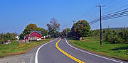
, passing through quaint Gardiner
Gardiner (CDP), New York
Gardiner is a hamlet in Ulster County, New York, USA. The population was 856 at the 2000 census.The community is near the center of the Town of Gardiner on routes 44 and 55.-Geography:...
and intersecting scenic NY 208
New York State Route 208
New York State Route 208 is a state highway located in southern New York in the United States. The southern terminus is at an intersection with NY 17M in the Orange County village of Monroe...
a mile east of the hamlet at a junction known as Ireland Corners.
Orchard
An orchard is an intentional planting of trees or shrubs that is maintained for food production. Orchards comprise fruit or nut-producing trees which are grown for commercial production. Orchards are also sometimes a feature of large gardens, where they serve an aesthetic as well as a productive...
s devoted to apple
Apple
The apple is the pomaceous fruit of the apple tree, species Malus domestica in the rose family . It is one of the most widely cultivated tree fruits, and the most widely known of the many members of genus Malus that are used by humans. Apple grow on small, deciduous trees that blossom in the spring...
s in this region of the county, crossing under the New York State Thruway
New York State Thruway
The New York State Thruway is a system of limited-access highways located within the state of New York in the United States. The system, known officially as the Governor Thomas E. Dewey Thruway for former New York Governor Thomas E. Dewey, is operated by the New York State Thruway Authority and...
between the hamlets of Modena
Modena, New York
Modena is an unincorporated hamlet in Ulster County, New York, United States. It is located in the northwestern corner of the town of Plattekill, centered at the junction of the US 44/NY 55 concurrency and NY 32. It has the ZIP Code 12548....
and Ardonia. No direct crossing is available, however access is available farther east via NY 299
New York State Route 299
New York State Route 299 is a short but important state route entirely within Ulster County, New York, United States. Centered around its interchange with the New York State Thruway outside New Paltz, it provides access from that road to the popular recreational attractions of the Shawangunk...
. Modena, 6 miles (10 km) from Gardiner, is marked by a traffic light
Traffic light
Traffic lights, which may also be known as stoplights, traffic lamps, traffic signals, signal lights, robots or semaphore, are signalling devices positioned at road intersections, pedestrian crossings and other locations to control competing flows of traffic...
at the intersection with NY 32
New York State Route 32
New York State Route 32 is a north–south state highway that extends for through the Hudson Valley and Capital District regions of the U.S. state of New York. It is a two-lane surface road for nearly its entire length, with few divided and no limited-access sections. From Harriman to Albany,...
, the major north–south state highway west of the Hudson.
East of Modena, through Clintondale, the road begins to climb once again into the glacial ridge separating this area from the river. At the notch 44–55 passes through, sweeping views are once again possible in good weather over the orchards ahead. A short descent and two more miles brings the highway to Highland
Highland, Ulster County, New York
Highland is a hamlet in Ulster County, New York, United States. The population was 5,060 at the 2000 census.Highland is a community in the Town of Lloyd, on U.S. Route 9W. Routes 44 and 55 run through it as well...
, the small unincorporated community across from Poughkeepsie
Poughkeepsie (city), New York
Poughkeepsie is a city in the state of New York, United States, which serves as the county seat of Dutchess County. Poughkeepsie is located in the Hudson River Valley midway between New York City and Albany...
. Just past it, 44–55 makes a tricky turn to join US 9W
U.S. Route 9W
U.S. Route 9W is a north–south U.S. Highway in the states of New Jersey and New York. It begins on Fletcher Avenue in Fort Lee, New Jersey as it crosses the US 1 & 9, US 46, and the Interstate 95 approaches to the George Washington Bridge, where it heads north up the west...
southbound. A mile-long concurrency past gas stations and fast-food restaurants ends at an overhead ramp to the Mid-Hudson Bridge
Mid-Hudson Bridge
The Mid-Hudson Bridge is a toll suspension bridge which carries US 44 and NY 55 across the Hudson River between Poughkeepsie and Highland in the state of New York. Governor and local resident Franklin D. Roosevelt and his wife Eleanor attended the opening ceremony on August 25, 1930. The bridge...
's toll plazas.
Poughkeepsie
The road then descends again and bends southward to the bridge approach through a deep rock cut. As it once again heads eastward to cross the river, the Poughkeepsie skyline sprawls ahead. Immediately upon entry into the city, offramps lead to the US 9U.S. Route 9
U.S. Route 9 is a north–south United States highway in the states of Delaware, New Jersey, and New York in the United States. It is one of only two U.S. highways with a ferry connection ; the other being US 10. US 9 is signed east–west in Delaware and north–south on the rest of...
freeway along the river's edge, and the nearby train station
Poughkeepsie (Metro-North station)
The Poughkeepsie Metro-North Railroad station serves Poughkeepsie, New York and surrounding areas as the north end of the Hudson Line. It is also served by many Amtrak trains, which continue north to Albany and points beyond, and south to New York City's Pennsylvania Station. Trains leave for New...
.
Pedestrian mall
Pedestrian malls in the United States are also known as pedestrian streets and are the most common form of pedestrian zone in large cities in the United States. It is a street lined with storefronts and closed off to most automobile traffic...
(known as the Main Mall
Main Mall
The Main Mall was an outdoor pedestrian shopping plaza in downtown Poughkeepsie, New York, which was in existence from 1973 until 2001. A urban renewal project designed with the intention of stopping the decline of the central business district of downtown Poughkeepsie, the mall was created by...
) between them. Only in Poughkeepsie's eastern end, shortly after the NY 376
New York State Route 376
New York State Route 376 is a state highway located entirely within Dutchess County in the Hudson Valley region of New York, United States. The route begins at an intersection with NY 52 in East Fishkill and passes north through Hopewell Junction and Red Oaks Mill on its way to the city...
junction near Vassar College
Vassar College
Vassar College is a private, coeducational liberal arts college in the town of Poughkeepsie, New York, in the United States. The Vassar campus comprises over and more than 100 buildings, including four National Historic Landmarks, ranging in style from Collegiate Gothic to International,...
, does two-way traffic return. Shortly afterwards, 44 and 55 part ways after over 30 miles (48 km).
Prior to the construction of Poughkeepsie's east–west arterial in the 1970s, 44 and 55 went on Church Street from the bridge to its intersection with Main Street, then on Main Street eastward to the outskirts of the city, where it forked into the two separate routes.
Dutchess County
From the split, NY 55 heads at first east, through LaGrangeLaGrange, New York
LaGrange is a town in Dutchess County, New York, United States. The population was 14,928 at the 2000 census. The town was named after the ancestral estate of the Marquis de Lafayette.-History:...
and its interchange with the Taconic State Parkway
Taconic State Parkway
The Taconic State Parkway , is a divided highway between Kensico Dam and Chatham, the longest parkway in the U.S. state of New York. It follows a generally northward route midway between the Hudson River and the Connecticut and Massachusetts state lines...
just east of Arlington High School
Arlington High School (LaGrange, New York)
Arlington High School is a high school in the Arlington Central School District located in Lagrangeville, New York, United States, on Route 55.-History:...
. It continues virtually due east to NY 82
New York State Route 82
New York State Route 82 is a state highway in the eastern Hudson Valley of New York, United States. It begins at an intersection with NY 52 northeast of the village of Fishkill, bends eastward towards Millbrook, and then returns westward to end at a junction with U.S. Route 9,...
at Billings, where it begins taking a more southeasterly tack.
This takes it to the eastern terminus of NY 216
New York State Route 216
New York State Route 216 is a short state highway located entirely in Dutchess County, New York, United States. At in length, it connects NY 52 and NY 55 between the hamlets of Stormville at the east end and Poughquag at the west...
at Poughquag, then up into the hills of the Town of Beekman
Beekman, New York
Beekman is a town in Dutchess County, New York, United States. It is part of the Poughkeepsie–Newburgh–Middletown, NY Metropolitan Statistical Area as well as the larger New York–Newark–Bridgeport, NY-NJ-CT-PA Combined Statistical Area. The population was 11,452 at the 2000...
, where the Appalachian Trail
Appalachian Trail
The Appalachian National Scenic Trail, generally known as the Appalachian Trail or simply the AT, is a marked hiking trail in the eastern United States extending between Springer Mountain in Georgia and Mount Katahdin in Maine. It is approximately long...
(AT) crosses the road and NY 292
New York State Route 292
New York State Route 292 is a short state highway in the Hudson Valley of New York, United States, bridging Putnam and Dutchess Counties. The southern terminus of the route is at an intersection with NY 311 in the town of Patterson, and the northern terminus is at a junction with...
comes to its northern end. Descending once again into the Harlem Valley, 55 reaches NY 22
New York State Route 22
New York State Route 22 is a north–south state highway in eastern New York in the United States. It runs parallel to the state's eastern edge from the outskirts of New York City to a short distance south of the Canadian border. At , it is the state's longest north–south route and...
just south of Pawling
Pawling (village), New York
Pawling is a village in Dutchess County, New York, USA. The population was 2,233 at the 2000 census. It is part of the Poughkeepsie–Newburgh–Middletown, NY Metropolitan Statistical Area as well as the larger New York–Newark–Bridgeport, NY-NJ-CT-PA Combined Statistical Area...
.
Instead of ending at this major north–south route, 55 joins it, heading north for 7 miles (11 km) and crossing the AT once again near the Metro-North flag stop
Appalachian Trail (Metro-North station)
The Appalachian Trail Metro-North Railroad station serves campers and hikers destined for the Appalachian Trail in Dutchess County, New York via the Harlem Line. Trains stop at Appalachian Trail on Saturdays, Sundays, and holidays only. It is the only train station along the 2,175 mile length of...
. At Webutuck, it leaves to the east, winding its way to the Connecticut state line after 3 miles (5 km). It becomes CT 55
Route 55 (Connecticut)
Route 55 is a state highway in the western part of the U.S. state of Connecticut, running from the New York state line in Sherman to New Milford...
, which continues another 2.6 miles (4 km) to its own eastern terminus at US 7
U.S. Route 7
U.S. Route 7 is a north–south United States highway in western New England that runs for from Norwalk, Connecticut, to Highgate, Vermont. The highway's southern terminus is at Interstate 95 in Norwalk, Connecticut...
.
Origins
The portion of modern NY 55 in Ulster CountyUlster County, New York
Ulster County is a county located in the state of New York, USA. It sits in the state's Mid-Hudson Region of the Hudson Valley. As of the 2010 census, the population was 182,493. Recent population estimates completed by the United States Census Bureau for the 12-month period ending July 1 are at...
from the intersection with County Route 7 west of Gardiner
Gardiner, New York
Gardiner is a town in Ulster County, New York, USA. The population was 5,238 at the 2000 census.The Town of Gardiner is in the south-central part of the county.- History :...
to U.S. Route 9W (US 9W) follows the Farmers' Turnpike, which was built by the Farmer's Turnpike & Bridge Company, a private company established in March 1808. Its purpose was to allow the transport of agricultural products from the Gardiner area to docks on the Hudson River
Hudson River
The Hudson is a river that flows from north to south through eastern New York. The highest official source is at Lake Tear of the Clouds, on the slopes of Mount Marcy in the Adirondack Mountains. The river itself officially begins in Henderson Lake in Newcomb, New York...
at Milton
Milton, Ulster County, New York
Milton is a hamlet in Ulster County, New York, United States. The population was 1,251 at the 2000 census.The community of Milton is located in the northeast part of the Town of Marlborough.- Geography :...
. The route at that time followed the north end of Albany Post Road (County Route 9) over the Shawangunk Kill
Shawangunk Kill
The Shawangunk Kill is a stream that flows northward through Orange, Sullivan and Ulster counties, New York, in the United States. It is the largest tributary of the Wallkill River....
and then east along the kill's south bank to ford
Ford (crossing)
A ford is a shallow place with good footing where a river or stream may be crossed by wading or in a vehicle. A ford is mostly a natural phenomenon, in contrast to a low water crossing, which is an artificial bridge that allows crossing a river or stream when water is low.The names of many towns...
the Wallkill River
Wallkill River
The Wallkill River, a tributary of the Hudson, drains Lake Mohawk in Sparta, New Jersey, flowing from there generally northeasterly to Rondout Creek in New York, near Rosendale, with the combined flows reaching the Hudson at Kingston....
just south of the confluence
Confluence
Confluence, in geography, describes the meeting of two or more bodies of water.Confluence may also refer to:* Confluence , a property of term rewriting systems...
. The turnpike company eventually went bankrupt.
New York
New York is a state in the Northeastern region of the United States. It is the nation's third most populous state. New York is bordered by New Jersey and Pennsylvania to the south, and by Connecticut, Massachusetts and Vermont to the east...
improved the former turnpike to state highway standards at a cost of just over $172,868 (equivalent to $ in ). The section from the Plattekill–Lloyd
Lloyd, New York
Lloyd is a town in Ulster County, New York, United States. The population was 9,941 at the 2000 census.The Town of Lloyd is located in the eastern part of Ulster County. U.S. Route 9W runs north and south in the eastern part of the town. The concurrent U.S. Route 44 and NY 55 pass through the...
town line north of Ardonia to what is now US 9W was added to the state highway system on September 9, 1911, as State Highway 350 (SH 350) while the portion from modern CR 7 to the west end of SH 350 was accepted into the state highway system on October 20, 1913, as SH 351. Both designations were assigned by the New York State Legislature for inventory purposes and were unsigned
Unsigned highway
An unsigned highway is a highway that has been assigned a route number, but does not bear conventional road markings that would normally be used to identify the route with that number...
.
In 1908, the legislature created a statewide system of unsigned legislative route
Legislative route
In United States, a legislative route or legislative highway is a highway defined by laws passed in a state legislature. The numbering of such highways may or may not correspond to the numbers familiar to the public as part of the state, U.S. highway, and Interstate highway systems...
s. No designation was assigned to most of the modern NY 55 corridor; however, the section of highway that NY 55 now shares with NY 22
New York State Route 22
New York State Route 22 is a north–south state highway in eastern New York in the United States. It runs parallel to the state's eastern edge from the outskirts of New York City to a short distance south of the Canadian border. At , it is the state's longest north–south route and...
from Pawling
Pawling (village), New York
Pawling is a village in Dutchess County, New York, USA. The population was 2,233 at the 2000 census. It is part of the Poughkeepsie–Newburgh–Middletown, NY Metropolitan Statistical Area as well as the larger New York–Newark–Bridgeport, NY-NJ-CT-PA Combined Statistical Area...
to Wingdale was designated as part of Route 1, a route extending from New York City
New York City
New York is the most populous city in the United States and the center of the New York Metropolitan Area, one of the most populous metropolitan areas in the world. New York exerts a significant impact upon global commerce, finance, media, art, fashion, research, technology, education, and...
to Albany
Albany, New York
Albany is the capital city of the U.S. state of New York, the seat of Albany County, and the central city of New York's Capital District. Roughly north of New York City, Albany sits on the west bank of the Hudson River, about south of its confluence with the Mohawk River...
. On March 1, 1921, the segment of NY 55 that overlaps with US 209 in Wawarsing
Wawarsing, New York
Wawarsing is a town in Ulster County, New York, United States. The population was 13,157 at the 2010 census. The name means "a place where the stream bends" in the Warwarsink language and refers to the geography of the land; particularly the joining of the Ver Nooy Kill and the Rondout Creek. The...
was included in Route 40, a new route that generally followed the modern US 209 corridor between Port Jervis
Port Jervis, New York
Port Jervis is a city on the Delaware River in western Orange County, New York, with a population of 8,860 at the 2000 census. The communities of Deerpark, Huguenot, Sparrowbush, and Greenville are adjacent to Port Jervis, and the towns of Montague, New Jersey and Matamoras, Pennsylvania face the...
and Kingston.
Designation
New York State Route 216
New York State Route 216 is a short state highway located entirely in Dutchess County, New York, United States. At in length, it connects NY 52 and NY 55 between the hamlets of Stormville at the east end and Poughquag at the west...
and NY 292
New York State Route 292
New York State Route 292 is a short state highway in the Hudson Valley of New York, United States, bridging Putnam and Dutchess Counties. The southern terminus of the route is at an intersection with NY 311 in the town of Patterson, and the northern terminus is at a junction with...
near Poughquag was signed as part of NY 39. NY 50 became part of US 6 in 1927. Over the next eight years, the highway went through several designations, becoming US 6N in 1928, NY 279 in 1933 and US 209 ca. 1935.
NY 39 was reassigned to another highway
New York State Route 39
New York State Route 39 is an east–west state highway in the western portion of New York in the United States. It begins and ends at intersections with U.S. Route 20 apart...
in western New York
Western New York
Western New York is the westernmost region of the state of New York. It includes the cities of Buffalo, Rochester, Niagara Falls, the surrounding suburbs, as well as the outlying rural areas of the Great Lakes lowlands, the Genesee Valley, and the Southern Tier. Some historians, scholars and others...
in the 1930 renumbering of state highways in New York. At the same time, NY 55 was assigned to much of its current alignment between Barryville
Barryville, New York
Barryville is a hamlet in Highland, Sullivan County, New York. It is named for William T. Barry, postmaster general under President Andrew Jackson. The community grew up around the D&H Canal, which opened in 1828 and operated until 1898...
and Pawling, utilizing the old Farmers' Turnpike in eastern Ulster County and a series of previously unnumbered roads in Sullivan
Sullivan County, New York
Sullivan County is a county located in the U.S. state of New York. As of the 2010 census, the population was 77,547. The county seat is Monticello. The name is in honor of Major General John Sullivan, who was a hero in the American Revolutionary War...
, western Ulster, and Dutchess
Dutchess County, New York
Dutchess County is a county located in the U.S. state of New York, in the state's Mid-Hudson Region of the Hudson Valley. The 2010 census lists the population as 297,488...
Counties. From Poughquag to West Pawling, NY 55 overlapped with NY 52
New York State Route 52
New York State Route 52 is a long state highway in the southeastern part of New York in the United States. It generally runs from west to east, beginning at the Pennsylvania state line in the Delaware River near Narrowsburg, crossing the Hudson River on the Newburgh-Beacon Bridge, and ending...
, which replaced NY 39 east of East Fishkill
East Fishkill, New York
East Fishkill is a town on the southern border of Dutchess County, New York, United States. The population was 25,589 at the 2000 census. The town name is derived from its formation from Fishkill, NY....
. Initially, NY 55 continued east from Pawling to the Connecticut
Connecticut
Connecticut is a state in the New England region of the northeastern United States. It is bordered by Rhode Island to the east, Massachusetts to the north, and the state of New York to the west and the south .Connecticut is named for the Connecticut River, the major U.S. river that approximately...
state line at Sherman
Sherman, Connecticut
Sherman is the northernmost and least populous town of Fairfield County, Connecticut, United States. The population was 3,581 at the 2010 census. The town is named for New Haven's Founding Father, Roger Sherman....
via Quaker Hill and Kirby Hill Roads.
In the early 1930s, the modern routing of NY 55 between Wingdale and the Connecticut border was designated as NY 341. The alignments of NY 55 and NY 341 east of NY 22 were flipped ca. 1934, placing NY 55 on its current alignment and NY 341 on NY 55's old routing. NY 55 reached Wingdale by way of a 7 miles (11 km) overlap with NY 22. When NY 55 was first assigned, it was routed along the northern bank of Rondout Creek
Rondout Creek
Rondout Creek is a tributary of the Hudson River in Ulster and Sullivan counties, New York, USA. It rises on Rocky Mountain in the eastern Catskills, flows south into Rondout Reservoir, part of New York City's water supply network, then into the valley between the Catskills and the Shawangunk...
between the hamlets of Grahamsville
Grahamsville, New York
Grahamsville is an unincorporated hamlet at the junction of NY 42 and 55 in the Town of Neversink, in Sullivan County, New York, USA. It is near the western end of Rondout Reservoir, and is the southernmost community in the Catskill Park...
and Lackawack. In the mid-1940s, NY 55 was realigned to follow a new highway along the southern bank while its former routing to the north became NY 55A
New York State Route 55A
New York State Route 55A is a state highway located in Sullivan and Ulster counties. It is a loop route connected to NY 55 at both ends, near Grahamsville in the west and Napanoch in the east...
. Both changes were made in order to accommodate the Rondout Reservoir
Rondout Reservoir
Rondout Reservoir is part of New York City's water supply network. It is located 75 miles northwest of the city in the Catskill Mountains, near the southern end of Catskill Park, split between the towns of Wawarsing in Ulster County and Neversink in Sullivan County...
, which was created ca. 1950 following the construction of the Merriman Dam.
NY 55A
New York State Route 55A
New York State Route 55A is a state highway located in Sullivan and Ulster counties. It is a loop route connected to NY 55 at both ends, near Grahamsville in the west and Napanoch in the east...
(9.52 miles or 15.32 km) is an alternate route of NY 55 along the north side of the Rondout Reservoir
Rondout Reservoir
Rondout Reservoir is part of New York City's water supply network. It is located 75 miles northwest of the city in the Catskill Mountains, near the southern end of Catskill Park, split between the towns of Wawarsing in Ulster County and Neversink in Sullivan County...
between Grahamsville
Grahamsville, New York
Grahamsville is an unincorporated hamlet at the junction of NY 42 and 55 in the Town of Neversink, in Sullivan County, New York, USA. It is near the western end of Rondout Reservoir, and is the southernmost community in the Catskill Park...
and Napanoch
Napanoch, New York
Napanoch is a hamlet in Ulster County, New York. It is at the junction of routes 209 and 55. It is on the Shawangunk Ridge National Scenic Byway, and is part of the Hudson River Valley National Heritage Area....
. It was assigned in the mid-1940s.