

Grahamsville, New York
Encyclopedia
New York State Route 42
New York State Route 42 is a north–south, discontinuous state highway in the Catskill Mountains region of New York in the United States. The southernmost of the highway's two segments begins at an intersection with U.S. Route 6 and US 209 in Port Jervis and ends at a junction with...
and 55
New York State Route 55
New York State Route 55 is a state highway in southern New York, running from the Pennsylvania state line at the Delaware River in Barryville to the Connecticut state line at Wingdale...
in the Town of Neversink
Neversink, New York
Neversink is a town in Sullivan County, New York, United States. The population was 3,553 at the 2000 census.The Town of Neversink is in the northeast corner of the county...
, in Sullivan County
Sullivan County, New York
Sullivan County is a county located in the U.S. state of New York. As of the 2010 census, the population was 77,547. The county seat is Monticello. The name is in honor of Major General John Sullivan, who was a hero in the American Revolutionary War...
, New York
New York
New York is a state in the Northeastern region of the United States. It is the nation's third most populous state. New York is bordered by New Jersey and Pennsylvania to the south, and by Connecticut, Massachusetts and Vermont to the east...
, USA. It is near the western end of Rondout Reservoir
Rondout Reservoir
Rondout Reservoir is part of New York City's water supply network. It is located 75 miles northwest of the city in the Catskill Mountains, near the southern end of Catskill Park, split between the towns of Wawarsing in Ulster County and Neversink in Sullivan County...
, and is the southernmost community in the Catskill Park. It has the ZIP Code
ZIP Code
ZIP codes are a system of postal codes used by the United States Postal Service since 1963. The term ZIP, an acronym for Zone Improvement Plan, is properly written in capital letters and was chosen to suggest that the mail travels more efficiently, and therefore more quickly, when senders use the...
12740 (also applied to the surrounding area) and the 985 telephone exchange
Telephone exchange
In the field of telecommunications, a telephone exchange or telephone switch is a system of electronic components that connects telephone calls...
in the 845
Area code 845
Area code 845 is a telephone area code which serves the Hudson Valley counties of Rockland, Putnam, Orange, most of Dutchess, Ulster, and Sullivan, plus parts of Delaware, Greene, and Columbia counties...
area code.
Grahamsville is located at latitude 41.848 and longitude -74.548. The elevation is 968 feet. Grahamsville is in the Eastern Time Zone.
Grahamsville in the town of Neversink, which has long been known in the area as being a "dry town" as the sale of alcohol is forbidden. There is a bar known as the Hasbrouck Tavern, located just outside the township.
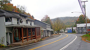
The center of Grahamsville, mainly located along Route 55 and Chestnut Creek
Chestnut Creek
-References:**USGS Hydrologic Unit Map - State of Virginia...
west of Route 42, consists of the town hall, post office
Post office
A post office is a facility forming part of a postal system for the posting, receipt, sorting, handling, transmission or delivery of mail.Post offices offer mail-related services such as post office boxes, postage and packaging supplies...
, fire department
Fire department
A fire department or fire brigade is a public or private organization that provides fire protection for a certain jurisdiction, which typically is a municipality, county, or fire protection district...
, and some other businesses, with an adjoining residential area. To the east of the junction is Tri-Valley Central School
Tri-Valley Central School
Tri-Valley Central School is located on NY 55, near Rondout Reservoir, east of the hamlet of Grahamsville in the town of Neversink, Sullivan County, New York, USA. It educates students from pre-kindergarten to twelfth grade in the Tri-Valley Central School District, which serves not only the town...
and the Grahamsville Historic District
Grahamsville Historic District
The Grahamsville Historic District is located along both sides of NY 55 just east of that hamlet in the Town of Neversink in Sullivan County, New York, USA. Its church is across the road from Tri-Valley Central School. In 1979 it was added to the National Register of Historic Places.Five buildings...
, listed on the National Register of Historic Places
National Register of Historic Places
The National Register of Historic Places is the United States government's official list of districts, sites, buildings, structures, and objects deemed worthy of preservation...
. It is the largest developed area in the town of Neversink.
Grahamsville is also the location of the Grahamsville Little World's Fair. This annual event features rides, vendors, and events like "Grahamsville Idol". Since 1878, this county fair has taken place every year except for 1928 when a flood destroyed the bridge to the fairgrounds and the area where the fair is held every year. The 131st Little World's Fair will be August 12 - August 15, 2010.
A Department of Environmental Protection branch was recently built in the heart of the town to increase the security near the Rondout and Neversink Reservoirs. These reservoirs are part of the water supply for New York City, so it is important that the environment in this region is safe from terrorism and any other kind of threat.
The buildings in the historic district reflect the early development of the community. The area was not settled permanently until after the War
American Revolutionary War
The American Revolutionary War , the American War of Independence, or simply the Revolutionary War, began as a war between the Kingdom of Great Britain and thirteen British colonies in North America, and ended in a global war between several European great powers.The war was the result of the...
due to a reputation for brutal raids by the Native American
Native Americans in the United States
Native Americans in the United States are the indigenous peoples in North America within the boundaries of the present-day continental United States, parts of Alaska, and the island state of Hawaii. They are composed of numerous, distinct tribes, states, and ethnic groups, many of which survive as...
population (the hamlet takes its name from the leader of a Continental Army
Continental Army
The Continental Army was formed after the outbreak of the American Revolutionary War by the colonies that became the United States of America. Established by a resolution of the Continental Congress on June 14, 1775, it was created to coordinate the military efforts of the Thirteen Colonies in...
unit massacred nearby in 1778) and the manorial land ownership system that remained in some areas of the Hudson Valley
Hudson Valley
The Hudson Valley comprises the valley of the Hudson River and its adjacent communities in New York State, United States, from northern Westchester County northward to the cities of Albany and Troy.-History:...
through the 1840s. The church and homes in the historic district are what grew up around the western end of a stage road (today part of Route 55) to Wawarsing
Wawarsing, New York
Wawarsing is a town in Ulster County, New York, United States. The population was 13,157 at the 2010 census. The name means "a place where the stream bends" in the Warwarsink language and refers to the geography of the land; particularly the joining of the Ver Nooy Kill and the Rondout Creek. The...
, nearby to the east in Ulster County
Ulster County, New York
Ulster County is a county located in the state of New York, USA. It sits in the state's Mid-Hudson Region of the Hudson Valley. As of the 2010 census, the population was 182,493. Recent population estimates completed by the United States Census Bureau for the 12-month period ending July 1 are at...
.