
.gif)
Reference marker (New York)
Encyclopedia

New York
New York is a state in the Northeastern region of the United States. It is the nation's third most populous state. New York is bordered by New Jersey and Pennsylvania to the south, and by Connecticut, Massachusetts and Vermont to the east...
, a reference marker is a small green sign mounted approximately every one-tenth mile on highways maintained by the New York State Department of Transportation. This was initiated in response to the Highway Safety Act of 1966
National Traffic and Motor Vehicle Safety Act
The National Traffic and Motor Vehicle Safety Act was enacted in the United States in 1966 to empower the federal government to set and administer new safety standards for motor vehicles and road traffic safety. The Act created the National Highway Safety Bureau...
enacted by Congress, in an effort to monitor traffic and identify high-accident locations. New York's system inventories and indexes all touring and reference routes, in addition to service and rest areas, ramps, and reservation roads.
New York's system is similar to California's postmile
California postmile
California uses a postmile system on all of its state highways, including U.S. Routes and Interstate Highways. The postmile markers indicate the distance a route travels through individual counties, as opposed to mile markers that indicate the distance traveled through a state.-Format:A postmile...
system in maintaining the state's highways and route logs. The New York State Thruway Authority adopted its own reference system for the New York State Thruway system, including I-287
Interstate 287
Interstate 287 is an auxiliary Interstate Highway in the U.S. states of New Jersey and New York. It is a partial beltway around New York City, serving the northern half of New Jersey and the counties of Rockland and Westchester in New York...
and I-84
Interstate 84 (east)
Interstate 84 is an Interstate Highway extending from Dunmore, Pennsylvania at an interchange with Interstate 81 to Sturbridge, Massachusetts, at an interchange with the Massachusetts Turnpike . I-84 has mile-log junction numbering in Pennsylvania; otherwise, exit numbers are roughly sequential...
. There is a similar reference marker system in use in neighboring Vermont
Vermont
Vermont is a state in the New England region of the northeastern United States of America. The state ranks 43rd in land area, , and 45th in total area. Its population according to the 2010 census, 630,337, is the second smallest in the country, larger only than Wyoming. It is the only New England...
.
Description
Top row
The top row indicates the route number. The letter "I" is used as a suffix for an Interstate highway, but may instead be a prefix on some markers. If a route is re-numbered, it will retain its old route marker (such as the WatervlietWatervliet, New York
Watervliet is a city in Albany County in the US state of New York. The population was 10,254 as of the 2010 census. Watervliet is north of Albany, the capital of the state, and is bordered on the north, west, and south by the town of Colonie. The city is also known as "the Arsenal City".- History...
segment of NY 2
New York State Route 2
New York State Route 2 is a state highway in the Capital District of New York, United States. It extends from an interchange with Interstate 87 and NY 7 in the hamlet of Latham within the town of Colonie to the Massachusetts state line, where it continues to Boston as Route 2....
, which was formerly NY 7
New York State Route 7
New York State Route 7 is a 180-mile long New York State Highway that runs from the New York/Pennsylvania border south of Binghamton, New York to the New York/Vermont border east of Hoosick. Most of the road runs along the Susquehanna Valley, closely paralleling Interstate 88 throughout...
until the mid-1980s). If a route number does not use all four digit spaces, there will be blank areas.
When two or more routes run concurrent or overlap, typically only the lower number highway will be present, or in some cases, a higher level highway's number (such as "88I" appearing on markers where NY 28
New York State Route 28
New York State Route 28 is a state highway extending for in the shape of a "C" between the Hudson Valley city of Kingston and southern Warren County in the U.S. state of New York. Along the way, it intersects several major routes, including Interstate 88 , U.S. Route 20 , and the...
overlaps Interstate 88
Interstate 88 (east)
Interstate 88 is an intrastate Interstate Highway entirely within the U.S. state of New York. Its western end is at Interstate 81 in Binghamton and its eastern end is at Interstate 90 in Schenectady. It serves as an important connector route from Albany to Binghamton, Elmira , and...
near Oneonta
Oneonta, New York
Oneonta is a city in southern Otsego County, New York, USA. As of the 2010 U.S. Census, had a population of 13,901. Its nickname is "City of the Hills." While the word "oneonta" is of undetermined origin, it is popularly believed to mean "place of open rocks" in the Iroquois language...
).
Center row
The first digit of the second row indicates the NYSDOT Region (1 through 11, with Region 10 (Long Island) being "0" and Region 11 (New York CityNew York City
New York is the most populous city in the United States and the center of the New York Metropolitan Area, one of the most populous metropolitan areas in the world. New York exerts a significant impact upon global commerce, finance, media, art, fashion, research, technology, education, and...
) being "X"). Within each of the regions, the counties are listed alphabetically and represented by the second digit. Thus, markers in Oswego County
Oswego County, New York
Oswego County is a county located in the U.S. state of New York. As of the 2010 Census, the estimated population was 122,109. The City of Oswego and the Village of Pulaski serve as the dual county seats in a two shire system of government...
bear the designation of "34" (Region 3, County 4 within said region).
Outside of New York City, the third and fourth digits of the second row indicate the number of counties the route has entered, starting at "01." Each county line crossing, no matter how short nor if re-entered, is counted. For example, the irregular boundaries of the counties of Oneida
Oneida County, New York
Oneida County is a county located in the U.S. state of New York. As of the 2010 census, the population was 234,878. The county seat is Utica. The name is in honor of the Oneida, an Iroquoian tribe that formerly occupied the region....
, Herkimer
Herkimer County, New York
Herkimer County is a county located in the U.S. state of New York. It was created in 1791 north of the Mohawk River out of part of Montgomery County. As of the 2010 census, the population was 64,519. It is named after General Nicholas Herkimer, who died from battle wounds in 1777 after taking part...
, and Otsego
Otsego County, New York
Otsego County is a county located in the U.S. state of New York. The 2010 population was 62,259. The county seat is Cooperstown. The name Otsego is from a Mohawk word meaning "place of the rock."-History:...
, and the routing of US 20
U.S. Route 20 in New York
U.S. Route 20 is a part of the U.S. Highway System that runs from Newport, Oregon, to Boston, Massachusetts. In the U.S. state of New York, US 20 extends from the Pennsylvania state line at Ripley to the Massachusetts state line in the Berkshire Mountains. US 20 is the longest...
through where the three counties meet, cause it to have four county crossings between Bridgewater
Bridgewater (village), New York
Bridgewater is a village in Oneida County, New York, USA. The population was 579 at the 2000 census.The Village of Bridgewater is within the Town of Bridgewater at the junction of US Route 20 and Route 8.- History :...
and West Winfield
West Winfield, New York
West Winfield is a village in the town of Winfield in Herkimer County, New York, United States. The population was 862 at the 2000 census. The village is indirectly named after General Winfield Scott, for whom the town is named...
, over a stretch of only 3.1 miles (5 km). This includes its first entry into Herkimer Country for roughly 170 feet (51.8 m). US 20 enters Herkimer and Otsego Counties three times each before entering Schoharie County
Schoharie County, New York
As of the census of 2000, there were 31,582 people, 11,991 households and 8,177 families residing in the county. The population density was 51 people per square mile . There were 15,915 housing units at an average density of 26 per square mile...
, which is number 18 in a sequence of 22 counties the route enters. The direction of inventory is either south-to-north, or west-to-east, as appropriate.
Within New York City, a different legend is applied for the third digit. The letter "M" for Mainline or "C" for Collector/Distributor road is used, with the letter "R" appearing for some ramps.
Bottom row
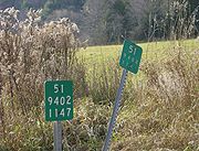
The first digit of the bottom row is the control segment, which starts at 1 at the county line or route's terminus. Control segments usually increment at each crossing of a city line, returning to 1 at the next county line. If a city has a high- and low-tax boundary, or otherwise annexes additional land, the control segments will in practice increment at the high tax (inner) boundary, or at the former boundary, rather than be re-numbered by NYSDOT if city boundaries change. If there are more than nine control segments in a county (such as on the Hutchinson River ParkwayHutchinson River Parkway
The Hutchinson River Parkway is a north–south parkway in southern New York, United States. It extends for from the massive Bruckner Interchange in the Throgs Neck section of the Bronx to the New York – Connecticut state line at Rye Brook...
in Westchester County
Westchester County, New York
Westchester County is a county located in the U.S. state of New York. Westchester covers an area of and has a population of 949,113 according to the 2010 Census, residing in 45 municipalities...
), the county counter will increment by one and the control segments reset to one. However, an entire county may be a single control segment; NY 10
New York State Route 10
New York State Route 10 is a north–south state highway in the Central New York and North Country regions of New York in the United States. It extends for from the Quickway in Deposit, Delaware County to NY 8 at Higgins Bay, a hamlet in the Hamilton County town of Arietta...
enters no cities and all control segments are numbered "1," despite its length.
In New York City, however, the first digit of the bottom row indicates the direction of travel, since county lines are crossed yet the route is still in the same city. North, South, East and West are represented respectively by 1, 2, 3, and 4.
The last three digits of the bottom row represent approximate distance in tenths of a mile from the beginning of the last control segment or county line.
Marker placement
Markers are placed on flanged posts at approximate one-tenth mile intervals with a tolerance of ±0.01 mile. On two-lane roads, they are usually placed in alternate directions of travel. On four-lane roads, they are placed in both directions. If an intersection, impermeable material, or other obstruction exists, a marker may be placed nearby but in violation of the above tolerance, on the opposite side of the road on which it would otherwise be placed, or missing altogether. A missing marker is yet accounted for in the overall sequence.A marker may also be placed on a nearby post that holds other warning or informational signs, or mounted on a bridge railing, guard rail, or other structure. Under the Latham traffic circle
Latham Circle
The Latham Circle is the intersection of US Route 9 and NY Route 2 within the town of Colonie, New York in Albany County.-Description:The circle takes the name from the hamlet of Latham, of which the circle is close to the exact center...
, markers for US 9 are mounted to the retaining wall.
A marker may be lost or disfigured due to a vehicle accident, maintenance/construction, snowplowing, or vandalism/theft. Markers are not present on roads not maintained by NYSDOT, which include city streets marked as a touring route, or bridges and ramps maintained by the New York State Bridge Authority
New York State Bridge Authority
The New York State Bridge Authority is a public benefit corporation in New York State, United States. The NYSBA was born out of the necessity for a bridge over the Hudson River to link the city of Hudson and the village of Catskill.-History:...
or other agency.
Other circumstances
Special situations call for the use of different legends in the digits of a marker.One-way couplets
When a route split onto two city streets, each one-way for the specific direction of travel, the northbound or eastbound markers are unchanged. Southbound or westbound, however, the letter "V" is inserted for the second digit of the third row. The markers are numbered in reverse sequence, so that the numbers match at the southern or western point of split and may be longer or shorter if a different distance is needed for the other direction. For example, both NY 5New York State Route 5
New York State Route 5 is a state highway that extends for across the state of New York in the United States. It begins at the Pennsylvania state line in the Chautauqua County town of Ripley and passes through Buffalo, Syracuse, Utica, Schenectady, and several other smaller cities and...
and NY 30
New York State Route 30
New York State Route 30 is a state highway in the central part of New York in the United States. It extends for from an interchange with NY 17 in the Southern Tier to the Canadian border in the state's North Country, where it continues into Quebec as Route 138. On a regional level,...
in Amsterdam
Amsterdam (city), New York
Amsterdam is a city located in Montgomery County, New York, USA. As of the 2010 census, the city had a total population of 18,620. The name is derived from the city of Amsterdam in the Netherlands....
are split: NY 5 is on Main Street westbound and the Amsterdam Arterial, eastbound; NY 30 is on Market Street southbound and Church Street, northbound. Both the southbound and westbound segments of both routes, maintained by NYSDOT, carry the "V" designation.
Interchange ramps
When markers are placed on access ramps, if the ramp carries a route, then that ramp's markers are part of the overall sequence. For ramps between two highways, the markers indicate the highway just departed (or the highway about to be entered, if the departed highway is not numbered). On the second row, instead of a county order, an exit order from "01" is present. This sequence is taken from the exit number of the higher level route (Interstate, over US Highway, over State Highway), and if the same level, the route with the lower number, from south to north or west to east. All markers for the same interchange will use the same sequencing number. If the ramp is for a service area, the sequencing number will use the format of "A1" through "Z9", but the letters "O" and "R" are not used.On the third row, the first digit is a DOT Residency (further division of a Region). The second is the letter "A" through "M", ordered counterclockwise starting with the higher level route's ramp oriented west–east or south–north, and is subject to interpretation. The last two digits are sequencing numbers, similar to the distance on a regular marker.
Service roads
On Service roads, the first row is the same as the mainline route with which the service road is associated, and uses the same second row. The third row begins with the aforementioned DOT Residency, followed by the letters N through Z, sequenced through the same county. The last two digits are the same sequencing number; if they exceed 9.9 miles (15.9 km), then the preceding letter will be incremented.Rest areas
Rest areas are used the same as ramps, but the county sequence will be replaced by the combination "R1" through "R9".Institutional roads (including Indian reservations)
A special route number is given to these roads, beginning with "9", then the digit for the region number ("0" in New York City), the number "1", then a letter. Reservation routes will begin the same way, with the third digit being any other than zero, and ending with the letter "R". The second row will have the same county designation, with the third and fourth digits being a sequence the same as a service road. The third row will begin with: 1, Reservations or Department of Health; 2, Military and Naval Affairs; 3, Education; 4, State Police; 5, Executive-Youth; 6, Conservation; 7, Corrections; 8, Social Services; 9, Mental Hygiene; O, Other.Realignments
If a new routing of a highway is constructed that is significantly different from the existing route, the legend will be varied to avoid duplication.If a new county is entered, the next available county order number will be used. For example, NY 3
New York State Route 3
New York State Route 3 is a major east–west state highway in New York, United States, that connects central New York to the North Country region near the Canadian border via Adirondack Park. The route extends for between its western terminus at an intersection with NY 104A in the Cayuga...
originally began at NY 104
New York State Route 104
New York State Route 104 is a long east–west state highway in Upstate New York, United States. It spans six counties and enters the vicinity of four cities—Niagara Falls, Lockport, Rochester, and Oswego—as it follows a routing largely parallel to that of the southern shoreline of Lake...
in Hannibal
Hannibal (village), New York
Hannibal is a village in Oswego County, New York, USA. The population was 542 at the 2000 census. The village is named after Hannibal, the hero of ancient Carthage....
in Oswego County
Oswego County, New York
Oswego County is a county located in the U.S. state of New York. As of the 2010 Census, the estimated population was 122,109. The City of Oswego and the Village of Pulaski serve as the dual county seats in a two shire system of government...
. Ending in Plattsburgh
Plattsburgh (city), New York
Plattsburgh is a city in and county seat of Clinton County, New York, United States. The population was 19,989 at the 2010 census. The population of the unincorporated areas within the Town of Plattsburgh was 11,870 as of the 2010 census; making the population for the immediate, urban Plattsburgh,...
, the country order ended with 07. Later, NY 3 was extended to the west at NY 104A
New York State Route 104A
New York State Route 104A is an east–west state highway in the central portion of New York in the United States. It serves as a northerly alternate route of NY 104, to which it connects at each end...
. With this extension entering Cayuga County
Cayuga County, New York
Cayuga County is a county located in the U.S. state of New York. It was named for one of the tribes of Indians in the Iroquois Confederation. Its county seat is Auburn.- History :...
, that segment used the county sequence of 08, even though it was to the west of Oswego County's 01.
If a realignment would require the use of new sequencing numbers, the first sequencing number (second digit) is increased by one, and the last two digits either start at 00 or at one higher than the end of the existing routing. Examples include the bypass of NY 43
New York State Route 43
New York State Route 43 is a state highway in Rensselaer County, New York, United States. It extends for from Interstate 90 exit 8 in North Greenbush to the Massachusetts state line, where it continues into Williamstown as Massachusetts Route 43...
in Rensselaer County
Rensselaer County, New York
Rensselaer County is a county in the U.S. state of New York. As of the 2010 census, the population was 159,429. Its name is in honor of the family of Kiliaen van Rensselaer, the original Dutch owner of the land in the area. Its county seat is Troy...
, replacing existing routing in and around Rensselaer
Rensselaer, New York
Rensselaer is a city in Rensselaer County, New York, United States, and is located on the Hudson River directly opposite Albany. As of the 2010 census, the city population was 9,392; in 1920, it was 10,832. The name is from Kiliaen van Rensselaer, the original landowner of the region in New...
; the construction of "Alternate 7" (NY 7
New York State Route 7
New York State Route 7 is a 180-mile long New York State Highway that runs from the New York/Pennsylvania border south of Binghamton, New York to the New York/Vermont border east of Hoosick. Most of the road runs along the Susquehanna Valley, closely paralleling Interstate 88 throughout...
between I-87
Interstate 87
Interstate 87 is a Interstate Highway located entirely within New York State in the United States of America. I-87 is the longest intrastate Interstate highway in the Interstate Highway System. Its southern end is at the Bronx approaches of the Robert F. Kennedy Bridge in New York City...
and I-787
Interstate 787
Interstate 787 is an auxiliary Interstate Highway in the U.S. state of New York. I-787 is the main highway for those traveling into and out of downtown Albany. The southern terminus is at the Interstate 87/New York State Thruway exit 23 toll plaza southwest of downtown Albany...
in Albany County
Albany County, New York
Albany County is a county located in the U.S. state of New York, and is part of the Albany-Schenectady-Troy Metropolitan Statistical Area. The name is from the title of the Duke of York and Albany, who became James II of England . As of the 2010 census, the population was 304,204...
), and the aforementioned NY 3
New York State Route 3
New York State Route 3 is a major east–west state highway in New York, United States, that connects central New York to the North Country region near the Canadian border via Adirondack Park. The route extends for between its western terminus at an intersection with NY 104A in the Cayuga...
between the Cayuga County line and its former terminus at NY 104
New York State Route 104
New York State Route 104 is a long east–west state highway in Upstate New York, United States. It spans six counties and enters the vicinity of four cities—Niagara Falls, Lockport, Rochester, and Oswego—as it follows a routing largely parallel to that of the southern shoreline of Lake...
.
In the event that the second digit in the third row increments beyond 9, the control segment number will be incremented by one. The control segment will also increment for a discontinuous route in the same county, such as NY 24
New York State Route 24
New York State Route 24 is an east–west state highway on Long Island in New York in the United States. The route is split into two segments, with the longest and westernmost of the two extending from Interstate 295 and NY 25 in the Queens Village section of the New York City...
in Suffolk County
Suffolk County, New York
Suffolk County is a county located in the U.S. state of New York on the eastern portion of Long Island. As of the 2010 census, the population was 1,493,350. It was named for the county of Suffolk in England, from which its earliest settlers came...
, as well for any crossings of the state line, such as NY 17
New York State Route 17
New York State Route 17 is a state highway that extends for through the Southern Tier and Downstate regions of New York in the United States...
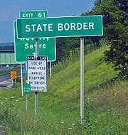
(future I-86) when the highway was re-routed around Waverly
Waverly, Tioga County, New York
----Waverly is the largest village in Tioga County, New York, United States. It is located southeast of Elmira in the Southern Tier region. This village was incorporated as the southwest part of the town of Barton in 1854...
and into Pennsylvania
Pennsylvania
The Commonwealth of Pennsylvania is a U.S. state that is located in the Northeastern and Mid-Atlantic regions of the United States. The state borders Delaware and Maryland to the south, West Virginia to the southwest, Ohio to the west, New York and Ontario, Canada, to the north, and New Jersey to...
(see photo above).
History
In an oddity, the former NY 57
New York State Route 57
New York State Route 57 was a major north–south state highway in Central New York, connecting downtown Syracuse to the Lake Ontario shoreline in Oswego. The southern terminus of the route was at U.S. Route 11 in Syracuse just north of downtown and a short distance east of Lake...
still retains many of its reference markers (in the old style) well after its decommissioning in 1980. The is also the case for former NY 380 in Chautauqua County.