

New York State Route 22
Encyclopedia
New York State Route 22 (NY 22) is a north–south state highway
in eastern New York
in the United States
. It runs parallel to the state's eastern edge from the outskirts of New York City
to a short distance south of the Canadian border. At 341 miles (549 km), it is the state's longest north–south route and the third longest overall, after NY 5
and NY 17
. Many of the state's major east–west roads intersect with Route 22 just before crossing the state line into the neighboring New England
states.
Almost all of Route 22 is a two-lane rural road that only passes through small villages and hamlets. The exceptions are its southern end in the heavily populated Bronx and lower Westchester County
, and a section of that runs through the city of Plattsburgh
near the northern end. The rural landscape that the road passes through varies from horse country and views of the picturesque reservoirs of the New York City watershed in the northern suburbs of the City, to dairy farms further upstate in the hilly Taconics
and Berkshires, to the undeveloped, heavily forested Adirondack Park along the shores of Lake Champlain
. An 86 miles (138 km) section from Fort Ann
to Keeseville
is part of the All-American Road known as the Lakes to Locks Passage
.
The southernmost section of the road was known as the White Plains Post Road in the eighteenth and nineteenth centuries, a major highway connecting New York City to White Plains
, the Westchester county seat
. Route 22 in its modern form was established in 1930 as one of the principal routes from New York City to Canada.
near Kensico Dam
before heading northward for good as a mostly two-lane rural route all the way to the Canadian border.
The majority of NY 22's 341 miles (549 km) routing is maintained by the New York State Department of Transportation
(NYSDOT); however, several sections are maintained by other jurisdictions. The southernmost of these is in the Bronx
, where the entirety of NY 22 within the borough
is maintained by the New York City Department of Transportation
(NYCDOT). In Westchester County
, NY 22 is mostly locally maintained within the city of Mount Vernon
and is county-maintained within the city of White Plains
. In Clinton County
, the route is locally maintained within the city of Plattsburgh
and county-maintained from U.S. Route 11
(US 11) to the Canadian border.
(US 1) in the Bronx
, intersecting with East 233rd Street
about 0.2 mile (0.321868 km) later. It soon crosses the Westchester
county line into Mount Vernon
and becomes South Third Avenue, beginning a 30 miles (48 km) section in that county. Shortly after the county line, Route 22 makes a sharp turn to the right at the South Columbus Avenue intersection. It parallels the nearby Hutchinson River Parkway
as it heads into the New York City suburbs of Bronxville
and Tuckahoe
. At Wilson Woods Lake, it crosses a pair of railroad tracks and becomes North Columbus Avenue, then has its first interchange with a limited-access road
at the Cross County Parkway
.
Two country club
s on either side herald NY 22's entry into the suburb of Scarsdale
. It makes a turn to the northeast, passing the Vernon Hills Shopping Center to the right. After leaving Scarsdale, NY 22 continues north into the hamlet of Hartsdale
.
The route parallels the Bronx River Parkway
(BRP) as it enters Westchester's county seat, White Plains
. Within the city of White Plains, NY 22 is maintained by Westchester County with the unsigned designations of County Route 53 (CR 53) from the Scarsdale line to NY 125, CR 108 between NY 125 and Westchester Avenue, and CR 87 from Broadway to the North Castle line. NY 22 also intersects NY 125
and NY 119
in downtown White Plains, then bends to the northwest along North Broadway, eventually intersecting the Cross-Westchester Expressway (Interstate 287 or I-287). White Plains Rural Cemetery
is visible to the west as NY 22 continues northward out of the city.
In North White Plains, the area that the road passes through becomes a little less developed as it goes over a gentle rise from which a short connector runs downhill to the traffic circle
where the BRP ends and the Taconic State Parkway
begins, just south of Kensico Dam.
with NY 120
, just north of IBM
's Armonk
headquarters and the "Duke's Trees angle", the westernmost point in Connecticut
. For the first time, NY 22 runs parallel to New York's eastern border, intersecting I-684 for the first of several times just north of the short portion of that highway in Connecticut. A short distance later, NY 433
, one of the state's shortest highways, heads south from NY 22 into Greenwich
.
After that junction, NY 22 bends back to the north, paralleling I-684 as a narrow, shaded meandering two-lane rural route through the Westchester countryside of large wooded lots and houses well-screened from the road. In downtown Bedford
, the first settlement since White Plains, the highway overlaps with NY 172
for a few blocks, then intersects NY 121
at its southern terminus. Route 22 itself follows a due-north heading from the hamlet, passing the John Jay Homestead State Historic Site
(the first National Historic Landmark
along the highway), and Harvey School, before it briefly widens at a major intersection with NY 35
near Katonah
. Two miles north of that junction, NY 22 becomes parallel to I-684 into the Town of Somers
and the hamlet of Goldens Bridge. On the other side of the interstate, accessible via NY 138
, is the Goldens Bridge train station on Metro-North Railroad
's Harlem Line, which begins a long parallel alignment with NY 22 at this point.
 The railroad's Purdy's
station is a short distance west of the next junction, NY 116
, after which NY 22 crosses under I-684, remaining between it and the railroad tracks. Turning left onto Hardscrabble Road, it follows the tracks away from the interstate to the site of the next station
, North Salem
's hamlet of Croton Falls. Just north of the hamlet, Route 22 crosses under the tracks, and is joined by US 202
. Immediately afterward, the road crosses back under the railroad again and enters Putnam County
, following the Croton River
north past the spillway
of East Branch Reservoir
.
After paralleling the reservoir for almost two miles (3 km), a third route, US 6
, joins the concurrency just east of the village of Brewster
. The three routes cross under a high, long bridge carrying I-84
, then veer east to an interchange with the north end of I-684. US 6 and 202 continue east for Danbury
while NY 22 uses the northbound on-ramp of the I-684 roadway. The short expressway connector that carries northbound I-684 traffic to northbound NY 22 is NY 981B, an unsigned reference route.
reservoirs. It then resumes its northward heading, following a much straighter course than it had up to this point, on two lanes through wooded areas of the town of Patterson
, where two local state highways, NY 312
and 164
, come in from the west. The highway gradually expands to three and sometimes four lanes as it passes through built-up areas of strip development. Shortly after intersecting a third state highway, NY 311
, and passing another strip plaza, NY 22 crosses into Dutchess County
.
After another supermarket strip to the east, a long, gentle divided
bend in the road almost a mile long ends with an overpass where NY 55
comes in from the west. It joins NY 22 as the two routes, returning to two lanes, pass through the eastern fringe of the village of Pawling
and then by Trinity-Pawling School
. Past the village, the railroad tracks edge closer to the highway as NY 22 enters the scenic Harlem Valley, which lends its name to the railroad line. The road curves more gently and takes longer straightaways, with lower density of residential and commercial development. Two miles from Pawling, the Appalachian Trail
crosses the road next to the line's Appalachian Trail station
. The flag stop allows hikers access to the nearby Pawling Nature Preserve
.
Routes 22 and 55 continue their long curve into the town of Dover
, past the Harlem Valley-Wingdale
station next to the road across from the now-closed buildings of Harlem Valley Psychiatric Center
. The NY 55 concurrency ends when that road heads towards Connecticut at Wingdale. The road continues through Dover Plains
and into Amenia, where an overlap with NY 343
begins. The railroad line ends at Wassaic
, the most distant Metro-North station from the city in direct miles
. Route 343 remains joined with Route 22 into the hamlet of Amenia, where it separates and heads towards state line. At the same junction, US 44
comes in from Millbrook
to begin an overlap with Route 22. The valley opens up as the southern Taconics
loom ahead. Shortly after crossing into the Town of North East
, the highway passes by the large Coleman Station Historic District
.
 After intersecting with NY 199
at its eastern end, NY 22 and US 44 veer northeast into the small village of Millerton
in the northern protrusion of Dutchess County's Oblong, an area once the subject of a boundary dispute between New York and Connecticut in the late 17th century. US 44 continues eastward towards Connecticut while NY 22 resumes its northward course into the shadow of the ridge ahead, where three states converge near the 2311 feet (704.4 m) Brace Mountain
, Dutchess County's highest, and Connecticut's highest point on Mount Frissell
's southern slope. At another gentle curve, NY 22 slips into Columbia County
and the town of Ancram
. North of the county line, Massachusetts
becomes the state behind Alander Mountain
and the other peaks visible to the east. The southernmost route from New York to the Massachusetts state line, NY 344
, leaves for Bashbish Falls State Park
at the hamlet of Copake Falls.
The next major junction is in Hillsdale
where NY 23
crosses NY 22 on its way to Catamount Ski Area
, which straddles the New York–Massachusetts state line. At the hamlet of Green River, NY 71, the state's shortest two-digit route, begins at NY 22 heading east into Massachusetts. NY 22 then crosses into Austerlitz
, where the surrounding terrain becomes much more wooded and the valleys become narrower. In the center of town, East Hill Road offers a short detour to Steepletop
, the farm where Edna St. Vincent Millay
lived. A short distance later, NY 22 intersects with NY 203
at its eastern end.
Route 22 then veers sharply to the northeast, resuming a northward direction only a short distance from the state line, a few hundred feet to the east. It then rounds a mountain and heads west, paralleling the New York State Thruway
's Berkshire section (I-90
) for a mile. NY 980D (an unsigned reference route) leaves to the east, where it becomes Massachusetts Route 102 at the state line. After Thruway exit B3, NY 22 resumes its northerly heading. From here it intersects NY 295
, then passes Queechy Lake
. NY 22 then straightens out to reach New Lebanon
, where it intersects US 20
. New York's longest east–west route (US 20) overlaps with its longest north–south route (NY 22) for a mile before the former continues to Pittsfield
and the latter returns to the border-paralleling course, which takes it into Rensselaer County
.
 As NY 22 continues north, it remains, at first, within a mile of Massachusetts, moving to the east to intersect with NY 43
in Stephentown
. North of that junction, it begins to run through a deep, isolated, lightly populated valley in the New York section of the Berkshires. Wide curves take the road through Berlin
, where Berlin Mountain
, the highest peak in the state outside of the Catskills and Adirondacks, caps the eastern skyline. Route 22 trends further west, then back east to where NY 2
crosses via an overpass at Petersburgh
on its way to Petersburg Pass, the northernmost crossing of the New York-Massachusetts state line. The next road to head east from NY 22, NY 346
at North Petersburgh, enters Vermont
.
Shortly afterward, the highway descends gently from the Berkshires to meet another major state road, NY 7
, and overlaps with it for a short distance. Two miles after that concurrency ends, NY 22 follows the upper Hoosic River
to Hoosick Falls
, the first village it has passed through since Millerton. There are no other state routes here, but after another 2 miles (3.2 km), at North Hoosick, NY 67
comes in from the east and the two roads overlap as they leave Rensselaer County.
, where NY 313
forks off to the east. In the middle of town, NY 372
, a local connector to Greenwich, ends.
 North of Cambridge, the highway continues through a rolling landscape of fields and farms, the low transitional country between the Appalachians
and the Adirondacks
. Beyond NY 29
's eastern terminus at Greenwich Junction, Route 22 heads eastward again through 18 miles (29 km) of countryside until, just before reaching Granville
, it comes within 0.5 miles (804.7 m) of the state line, the closest it has come to that boundary since Austerlitz. At the village's south end, NY 22 intersects NY 149
and the two routes overlap for several blocks until NY 149 begins its short journey to Vermont. Just north of Granville, the first of NY 22's two suffixed routes, NY 22A
, begins its route running closely parallel to the state line and then into Vermont, where it becomes Vermont Route 22A, paralleling the parent route for some distance on the other side of the state line.
Immediately after this junction, NY 22 begins a long curve away from the state line that has it running due west at the end of NY 40
in North Granville. It heads northwest a little further until, after passing between Great Meadows
and Washington
state prisons, it reaches US 4
and turns right to join it, resuming its northward course. The overlap with US 4, one of the few along Route 22 that pairs it with another north–south route, lasts for seven miles (11 km) along the base of the Adirondack foothills between the low country and Lake George
, before ending in Whitehall
, where US 4 leaves to assume the east–west course it takes across northern New England.
. The lake's South Bay, which the road crosses immediately after this turn, is also the Blue Line
. Route 22 has now entered Adirondack Park, the 6100000 acres (24,685.8 km²) Forest Preserve
and National Historic Landmark
, and the largest state-level protected area
in any state. Within the park, NY 22 mainly follows the lakeshore, closer to some of its more populated areas.
It continues along the hillside of Black Mountain, Washington County's highest peak, as it meanders north on the narrowing isthmus
between Lakes Champlain and George. Near the northern end, it crosses the Essex County
line. Two miles later, it reaches the first settlement along its length within the Adirondack Park, Ticonderoga
. The highway skirts the northeastern edge of the village, the site of key battles
in both the French and Indian
and Revolutionary
Wars, as NY 74
comes in from the ferry to the east. This overlap lasts for almost two miles (3 km) until NY 74 goes straight ahead at the intersection with NY 9N
, while NY 22 turns right to join NY 9N, the longest suffixed route in the state, and return to its northbound orientation.
At first, Routes 22 and 9N veer west, away from the lake, but then return to its shoreline to avoid a nearby mountain, just before Crown Point
. NY 185
, a small connector road, runs from 9N and 22 along the peninsula to become VT 17
. They remain close to the widening lake for the next 15 miles (24 km) through Port Henry
to Westport
, where 9N leaves heading west for Elizabethtown
. Beyond that junction, Route 22 again turns inland, going through the easy pass around Split Rock Mountain. At Bouquet, it makes an abrupt right turn to go due east back to the lakeshore and ferry landing at Essex
.
Route 22 heads to the northwest again, away from the lake, until it heads west and intersects US 9 in the town of Chesterfield
, the other major north–south surface route up the state's eastern side. Routes 22 and 9 join together, closely parallel to the Adirondack Northway (I-87), the only other route in the state to directly connect New York City with Canada. The three routes, spread over many miles in the southern part of the state, run through a narrow corridor for two miles (3 km) until Routes 9 and 22 veer east again toward Keeseville
.
Here, Route 9N ends and Routes 9 and 22 separate. The two will exchange corridors, with US 9 following the lake shore line while NY 22 remains mostly inland. NY 22 enters Clinton County
just north of Keeseville, and then leaves Adirondack Park 2 miles (3.2 km) beyond at the Peru
town line.
, the short NY 442
terminates at Route 22. In the hamlet itself, after the Little Au Sable River crossing, NY 22's other suffixed route, NY 22B, branches off further inland. NY 22 continues north of Peru, and returns to the Northway's side again in a mile. After another five miles (8 km), it has its first exit on the Northway near the now-closed Plattsburgh Air Force Base
. It continues northeastward, crossing the Saranac River
into Plattsburgh
, the first city and most populous community NY 22 has passed through since White Plains.
NY 22 runs along South Catherine Street for a few blocks, then divides into one-way couplets for the first time since Westchester County, with northbound traffic moving a block to the east to follow Oak Street, while southbound traffic comes down North Catherine Street. It parallels US 9 for a couple of blocks, intersecting NY 3
(Cornelia Street) just a block west of its eastern terminus at that highway. After Boynton Avenue, the separate streets reunite and turns northwest just before it has its second and final exit with the Northway. Just after the exit, NY 374
begins along the westbound route as NY 22 turns to the north once again.
The highway follows the railroad tracks into Beekmantown
until it bears left at a fork, trending further west to Beekmantown Corners, where another short local road, NY 456
, comes to its western end. After crossing into the next town, Chazy
, NY 22 bears left again at another fork to drift further to the west. The terrain around the road becomes increasingly wooded, with long unbroken stretches of pine, in the northern portion of the town. This is briefly broken at another western terminus of a short local road, NY 191
, in the hamlet of Sciota.
Route 22 continues past Sciota in a fairly straight north-northwesterly course through more woods with small home and farm clearings. Those yield to mostly fields just before the Great Chazy River, after which NY 22 enters the hamlet of Mooers
. As signed, NY 22 comes to an end upon intersecting US 11
; however, it officially overlaps with US 11 west to Hemmingford Road, where it turns north to follow Hemmingford Road north to the Canadian border. The highway continues north into the province of Quebec
as Route 219
.
to transport iron south from the mines in the Adirondacks.
Once White Plains
became the county seat of Westchester
in 1759, the road between this village and the city of New York (then encompassing only Manhattan
) became an important route and was established as the White Plains Post Road. Before 1797, the main road heading to points north and east out of Manhattan went via Kingsbridge
along the old Boston Post Road
. A new bridge over the Harlem River
(the original Harlem Bridge) was opened in 1797, shortening the route out of Manhattan. This also relocated the Boston and White Plains Post Roads to a new alignment along Third Avenue and Boston Road. The White Plains Post Road separated from the Boston Post Road in Bronxdale, with the road to Boston heading east and the road to White Plains heading north. The old White Plains Post Road roughly followed the alignment of modern-day White Plains Road, which was laid out in 1863. (The original post road was to the east of the modern-day avenue). The White Plains Post Road continued north through Olinville, Wakefield, and Mount Vernon
, where the route shifted east to modern-day White Plains Post Road, going through Bronxville
and Scarsdale
to White Plains
.
The stretch from Salem to the Vermont
border in Granville
was part of the old Northern Turnpike, which began in Lansingburgh
and went along modern-day Route 40
. The Northern Turnpike was chartered on April 1, 1799.
formed a commission "to regulate, grade, widen, gravel, and improve the old White Plains Post Road", which was amended in 1870 to "macadamize the road" between Mount Vernon and White Plains. The post road south of Mount Vernon, which was part of New York City, was later widened between 1902 and 1908.
State highway
s were first formally defined by the state legislature in 1909 and given numeric designations, although these initial designations were not publicly signed. Portions of modern Route 22 were defined as part of legislative routes 1 and 22. Legislative route 1 went from the New York City line north along the White Plains Post Road to White Plains, then detoured to Harrison (via Westchester Avenue), before proceeding north to Armonk
(via modern NY 120
). Legislative route 1 continued north along modern NY 22 to Austerlitz, where it then turned northwest to Valatie (via modern NY 203
), then followed US 9 to Albany. Legislative route 22 had two segments. The southern segment began in Troy, following NY 7
to Hoosick, then went north along modern NY 22 up to Putnam Station (south of Ticonderoga).
(at the intersection with NY 23
). By 1929, the road to Valatie had been improved and NY 22 was extended to US 9, with a length of 139 miles (224 km). The middle section of modern NY 22 was designated in 1924 as NY 24, running for 75 miles (121 km) from Stephentown
to Comstock. The portion of modern NY 22 north of Whitehall remained unnumbered in 1924 but gained a designation in 1925 when NY 30, a route assigned in 1924 that linked Mechanicville
to Whitehall, was extended north from Whitehall to the Canadian border north of Mooers
. In the 1930 renumbering, the NY 24 and NY 30 designations were both reassigned elsewhere. The NY 22 designation was extended north along old NY 24 and NY 30, incorporating newly improved roads between Austerlitz and Stephentown, resulting in a route length of 370 miles (595 km). The segment of old NY 22 between Austerlitz and Valatie was renumbered to NY 203
.
In December 1934, at the insistence of the Automobile Club of New York, several numbered routes were extended and signed within New York City
, with NY 22 being one of these routes. NY 22 was extended south from the Mount Vernon line in the Bronx along White Plains Road
, then it shifted via East 233rd Street
to Webster Avenue
until Fordham Road
(US 1). From Fordham Road, it continued south along the Grand Concourse
(overlapped with NY 100
), crossing into Manhattan via East 149th Street to the 145th Street Bridge
. In Manhattan, the NY 22/100 pair continued south along Lenox Avenue, 110th Street
, Fifth Avenue, 96th Street
, and Park Avenue
, ending at Houston Street (NY 1A
). By 1941, the alignment within Mount Vernon was shifted east to use Columbus Avenue and South 3rd Avenue (current NY 22), continuing its route to New York City via East 233rd Street as before. On January 1, 1970, the NY 22 designation was removed from Manhattan and most of the Bronx, and the short piece remaining in the city was realigned to meet US 1 at its current southern terminus.
was defined as beginning in New York City and designated on the alignment of NY 22 to Amenia, where it shifted northeast into Sharon, Connecticut
to use old New England Route 4 through Massachusetts and Vermont all the way to the Canadian border. Apparently New York State did not approve this plan, and by mid-1927 the official route log published by AASHO (now known as AASHTO) had been amended so that the southern end of US 7 began in Norwalk, Connecticut
instead.
) was designated solely as Route 22. The north end of NY 47 was also located at an intersection with Route 22 in Ticonderoga. At Westport, NY 22 connected to NY 195, an east–west highway leading to Elizabethtown. At the time, Route 9N only stretched from Elizabethtown to Keeseville. NY 9N was extended southward to Lake George ca. 1936, supplanting NY 47 and NY 195 and becoming concurrent with NY 22 between Ticonderoga and Westport.
NY 8 originally extended eastward from Hague to a ferry across Lake Champlain
at Putnam
when it was assigned as part of the renumbering. In between the two locations, the route utilized modern NY 9N, Montcalm Street, NY 22, and Wrights Ferry and Wrights Roads. It was realigned in the early 1930s to continue east from Ticonderoga on what is now NY 74
to another ferry across the lake. Ca. 1934, NY 8 was altered again to follow NY 22 north from Ticonderoga to Crown Point, where it turned off the highway onto Bridge Road (now NY 185
). Route 8 remained intact along this routing until ca. 1968, when Route 8 was truncated southwestward to NY 9N in Hague
.
. In Dover Plains
, the southern leg of NY 22's junction with NY 343
is maintained by the state as NY 980G, a reference route. To the north in the town of Amenia
, a 4.03 miles (6.49 km) long loop off NY 22 between Wassaic
and Amenia
is designated as CR 81. Another former routing of NY 22 in the town of Dover
exists as CR 6, a loop route between the hamlets of Wingdale and Dover Plains that runs along the west bank of the Tenmile River. Within the 44/22 concurrency, the intersection with CR 5 south of Millerton is also a former alignment of Route 22.
Before the construction of I-684, NY 22 continued northeast along Sodom Road north of Brewster
on what is now CR 50, a dead-end road maintained by Putnam County. Modern NY 22 joins the I-684 roadway at exit 10 (the northern terminus of I-684) and connects to the surface road on the opposite side of the Croton River
via the NY 981B connector. South of Copake Falls, the state also still maintains an old alignment designated as NY 980F. North of Copake Falls, the northern half of the original alignment was designated as an extension of NY 344
.
as part of a highway maintenance swap between the county and the state of New York. Following the swap, it was co-designated as CR 34 by Clinton County. In 2008, the signed northern terminus of NY 22 was moved to the east end of its overlap with US 11
in Mooers. The official alignment of NY 22 was not changed, however, as the New York State Department of Transportation
still considers the Canadian border to be NY 22's northern terminus as of March 2010.
.
State highway
State highway, state road or state route can refer to one of three related concepts, two of them related to a state or provincial government in a country that is divided into states or provinces :#A...
in eastern New York
New York
New York is a state in the Northeastern region of the United States. It is the nation's third most populous state. New York is bordered by New Jersey and Pennsylvania to the south, and by Connecticut, Massachusetts and Vermont to the east...
in the United States
United States
The United States of America is a federal constitutional republic comprising fifty states and a federal district...
. It runs parallel to the state's eastern edge from the outskirts of New York City
New York City
New York is the most populous city in the United States and the center of the New York Metropolitan Area, one of the most populous metropolitan areas in the world. New York exerts a significant impact upon global commerce, finance, media, art, fashion, research, technology, education, and...
to a short distance south of the Canadian border. At 341 miles (549 km), it is the state's longest north–south route and the third longest overall, after NY 5
New York State Route 5
New York State Route 5 is a state highway that extends for across the state of New York in the United States. It begins at the Pennsylvania state line in the Chautauqua County town of Ripley and passes through Buffalo, Syracuse, Utica, Schenectady, and several other smaller cities and...
and NY 17
New York State Route 17
New York State Route 17 is a state highway that extends for through the Southern Tier and Downstate regions of New York in the United States...
. Many of the state's major east–west roads intersect with Route 22 just before crossing the state line into the neighboring New England
New England
New England is a region in the northeastern corner of the United States consisting of the six states of Maine, New Hampshire, Vermont, Massachusetts, Rhode Island, and Connecticut...
states.
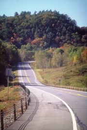
Almost all of Route 22 is a two-lane rural road that only passes through small villages and hamlets. The exceptions are its southern end in the heavily populated Bronx and lower Westchester County
Westchester County, New York
Westchester County is a county located in the U.S. state of New York. Westchester covers an area of and has a population of 949,113 according to the 2010 Census, residing in 45 municipalities...
, and a section of that runs through the city of Plattsburgh
Plattsburgh (city), New York
Plattsburgh is a city in and county seat of Clinton County, New York, United States. The population was 19,989 at the 2010 census. The population of the unincorporated areas within the Town of Plattsburgh was 11,870 as of the 2010 census; making the population for the immediate, urban Plattsburgh,...
near the northern end. The rural landscape that the road passes through varies from horse country and views of the picturesque reservoirs of the New York City watershed in the northern suburbs of the City, to dairy farms further upstate in the hilly Taconics
Taconic Mountains
The Taconic Mountains or Taconic Range are a physiographic section of the larger New England province and part of the Appalachian Mountains, running along the eastern border of New York State and adjacent New England from northwest Connecticut to western Massachusetts, north to central western...
and Berkshires, to the undeveloped, heavily forested Adirondack Park along the shores of Lake Champlain
Lake Champlain
Lake Champlain is a natural, freshwater lake in North America, located mainly within the borders of the United States but partially situated across the Canada—United States border in the Canadian province of Quebec.The New York portion of the Champlain Valley includes the eastern portions of...
. An 86 miles (138 km) section from Fort Ann
Fort Ann (village), New York
Fort Ann is a village in Washington County, New York, United States. It is part of the Glens Falls Metropolitan Statistical Area. The village population was 471 at the 2000 census...
to Keeseville
Keeseville, New York
Keeseville is a village in both Clinton County, New York and in Essex County, New York in the United States. The population was 1,815 at the 2010 census. The village is named after the Keese family....
is part of the All-American Road known as the Lakes to Locks Passage
Lakes to Locks Passage
The New York State byway known as Lakes to Locks Passage unifies the interconnected waterway of the upper Hudson River, Champlain Canal, Lake George, and Lake Champlain; this waterway is the core of North America’s first “super-highway” between upstate New York, USA and the Province of Quebec, Canada...
.
The southernmost section of the road was known as the White Plains Post Road in the eighteenth and nineteenth centuries, a major highway connecting New York City to White Plains
White Plains, New York
White Plains is a city and the county seat of Westchester County, New York, United States. It is located in south-central Westchester, about east of the Hudson River and northwest of Long Island Sound...
, the Westchester county seat
County seat
A county seat is an administrative center, or seat of government, for a county or civil parish. The term is primarily used in the United States....
. Route 22 in its modern form was established in 1930 as one of the principal routes from New York City to Canada.
Route description
Route 22 starts as an urban arterial road, passing through the most populous communities along its route within its first 15 miles (24 km). After running northerly from its origin in the Bronx it veers slightly to the northeast in the vicinity of a traffic circleTraffic circle
A traffic circle or rotary is a type of circular intersection in which traffic must travel in one direction around a central island. In some countries, traffic entering the circle has the right-of-way and drivers in the circle must yield. In many other countries, traffic entering the circle must...
near Kensico Dam
Kensico Reservoir
The Kensico Reservoir is a reservoir, located in the village of Valhalla and in the town of North Castle, that was put into service in 1915. It is about 3 miles north of White Plains, New York, and about 15 miles north of New York City...
before heading northward for good as a mostly two-lane rural route all the way to the Canadian border.
The majority of NY 22's 341 miles (549 km) routing is maintained by the New York State Department of Transportation
New York State Department of Transportation
The New York State Department of Transportation is responsible for the development and operation of highways, railroads, mass transit systems, ports, waterways and aviation facilities in the U.S...
(NYSDOT); however, several sections are maintained by other jurisdictions. The southernmost of these is in the Bronx
The Bronx
The Bronx is the northernmost of the five boroughs of New York City. It is also known as Bronx County, the last of the 62 counties of New York State to be incorporated...
, where the entirety of NY 22 within the borough
Borough (New York City)
New York City, one of the largest cities in the world, is composed of five boroughs. Each borough now has the same boundaries as the county it is in. County governments were dissolved when the city consolidated in 1898, along with all city, town, and village governments within each county...
is maintained by the New York City Department of Transportation
New York City Department of Transportation
The New York City Department of Transportation is responsible for the management of much of New York City's transportation infrastructure...
(NYCDOT). In Westchester County
Westchester County, New York
Westchester County is a county located in the U.S. state of New York. Westchester covers an area of and has a population of 949,113 according to the 2010 Census, residing in 45 municipalities...
, NY 22 is mostly locally maintained within the city of Mount Vernon
Mount Vernon, New York
Mount Vernon is a city in Westchester County, New York, United States. It lies on the border of the New York City borough of The Bronx.-Overview:...
and is county-maintained within the city of White Plains
White Plains, New York
White Plains is a city and the county seat of Westchester County, New York, United States. It is located in south-central Westchester, about east of the Hudson River and northwest of Long Island Sound...
. In Clinton County
Clinton County, New York
Clinton County is a county located in the U.S. state of New York. As of the 2010 census, the population was 82,128. Its name is in honor of the first Governor of New York as a state, George Clinton. Its county seat is Plattsburgh.-History:...
, the route is locally maintained within the city of Plattsburgh
Plattsburgh (city), New York
Plattsburgh is a city in and county seat of Clinton County, New York, United States. The population was 19,989 at the 2010 census. The population of the unincorporated areas within the Town of Plattsburgh was 11,870 as of the 2010 census; making the population for the immediate, urban Plattsburgh,...
and county-maintained from U.S. Route 11
U.S. Route 11 in New York
U.S. Route 11 is a part of the U.S. Highway System that runs from New Orleans, Louisiana, to the Canadian border at Rouses Point, New York...
(US 11) to the Canadian border.
Bronx to Kensico Dam
Route 22 starts as Provost Avenue at an intersection with U.S. Route 1U.S. Route 1 in New York
U.S. Route 1 is a part of the U.S. Highway System that runs from Key West, Florida, to the Canada – United States border at Fort Kent, Maine. In the U.S. state of New York, US 1 extends from the George Washington Bridge in Manhattan to the Connecticut state line at Port Chester...
(US 1) in the Bronx
The Bronx
The Bronx is the northernmost of the five boroughs of New York City. It is also known as Bronx County, the last of the 62 counties of New York State to be incorporated...
, intersecting with East 233rd Street
East 233rd Street (Bronx)
East 233rd Street is one of the major thoroughfares of the Bronx. The road is 3 miles long and stretches from U.S. Route 1 in the Eastchester section of the Bronx to the Major Deegan Expressway in Woodlawn . The road changes names from East 233rd Street to Pinkley Avenue after the...
about 0.2 mile (0.321868 km) later. It soon crosses the Westchester
Westchester County, New York
Westchester County is a county located in the U.S. state of New York. Westchester covers an area of and has a population of 949,113 according to the 2010 Census, residing in 45 municipalities...
county line into Mount Vernon
Mount Vernon, New York
Mount Vernon is a city in Westchester County, New York, United States. It lies on the border of the New York City borough of The Bronx.-Overview:...
and becomes South Third Avenue, beginning a 30 miles (48 km) section in that county. Shortly after the county line, Route 22 makes a sharp turn to the right at the South Columbus Avenue intersection. It parallels the nearby Hutchinson River Parkway
Hutchinson River Parkway
The Hutchinson River Parkway is a north–south parkway in southern New York, United States. It extends for from the massive Bruckner Interchange in the Throgs Neck section of the Bronx to the New York – Connecticut state line at Rye Brook...
as it heads into the New York City suburbs of Bronxville
Bronxville, New York
Bronxville is an affluent village within the town of Eastchester, New York, in the United States. It is a suburb of New York City, located approximately north of midtown Manhattan in southern Westchester County. At the 2010 census, Bronxville had a population of 6,323...
and Tuckahoe
Tuckahoe, Westchester County, New York
Tuckahoe is a village in the town of Eastchester in Westchester County, New York, United States. As of the 2010 census, the village's population was 6,486....
. At Wilson Woods Lake, it crosses a pair of railroad tracks and becomes North Columbus Avenue, then has its first interchange with a limited-access road
Limited-access road
A limited-access road known by various terms worldwide, including limited-access highway, dual-carriageway and expressway, is a highway or arterial road for high-speed traffic which has many or most characteristics of a controlled-access highway , including limited or no access to adjacent...
at the Cross County Parkway
Cross County Parkway
The Cross County Parkway is a long parkway in Westchester County, New York. The parkway is a critical east–west connection throughout Westchester, having full interchanges with every major north–south parkway in southern Westchester, in addition to the New York State Thruway mainline....
.
Two country club
Country club
A country club is a private club, often with a closed membership, that typically offers a variety of recreational sports facilities and is located in city outskirts or rural areas. Activities may include, for example, any of golf, tennis, swimming or polo...
s on either side herald NY 22's entry into the suburb of Scarsdale
Scarsdale, New York
Scarsdale is a coterminous town and village in Westchester County, New York, United States, in the northern suburbs of New York City. The Town of Scarsdale is coextensive with the Village of Scarsdale, but the community has opted to operate solely with a village government, one of several villages...
. It makes a turn to the northeast, passing the Vernon Hills Shopping Center to the right. After leaving Scarsdale, NY 22 continues north into the hamlet of Hartsdale
Hartsdale, New York
Hartsdale is a hamlet and a census-designated place located in the town of Greenburgh, Westchester County, New York. The population was 5,293 at the 2010 census.-Geography:Hartsdale is located at ....
.
The route parallels the Bronx River Parkway
Bronx River Parkway
The Bronx River Parkway is a long parkway in downstate New York. It is named for the nearby Bronx River, which it parallels. The southern terminus of the parkway is at Story Avenue near Bruckner Expressway in the Bronx neighborhood of Soundview...
(BRP) as it enters Westchester's county seat, White Plains
White Plains, New York
White Plains is a city and the county seat of Westchester County, New York, United States. It is located in south-central Westchester, about east of the Hudson River and northwest of Long Island Sound...
. Within the city of White Plains, NY 22 is maintained by Westchester County with the unsigned designations of County Route 53 (CR 53) from the Scarsdale line to NY 125, CR 108 between NY 125 and Westchester Avenue, and CR 87 from Broadway to the North Castle line. NY 22 also intersects NY 125
New York State Route 125
New York State Route 125 is a long north–south state highway in Westchester County, New York. The route begins in The Town of Mamaroneck at U.S...
and NY 119
New York State Route 119
New York State Route 119 is an east–west state highway in Westchester County, New York, in the United States. The road starts in Tarrytown at an intersection with U.S. Route 9 and comes to an end at a junction with NY 22 in White Plains...
in downtown White Plains, then bends to the northwest along North Broadway, eventually intersecting the Cross-Westchester Expressway (Interstate 287 or I-287). White Plains Rural Cemetery
White Plains Rural Cemetery
White Plains Rural Cemetery is a historic rural cemetery located at White Plains, Westchester County, New York. The cemetery was organized in 1854 and designed in 1855. It contains miles of narrow, paved roads, none of which is in a straight line. The roads create circular and lozenge-shaped...
is visible to the west as NY 22 continues northward out of the city.
In North White Plains, the area that the road passes through becomes a little less developed as it goes over a gentle rise from which a short connector runs downhill to the traffic circle
Traffic circle
A traffic circle or rotary is a type of circular intersection in which traffic must travel in one direction around a central island. In some countries, traffic entering the circle has the right-of-way and drivers in the circle must yield. In many other countries, traffic entering the circle must...
where the BRP ends and the Taconic State Parkway
Taconic State Parkway
The Taconic State Parkway , is a divided highway between Kensico Dam and Chatham, the longest parkway in the U.S. state of New York. It follows a generally northward route midway between the Hudson River and the Connecticut and Massachusetts state lines...
begins, just south of Kensico Dam.
Kensico Reservoir to Brewster
While the Taconic State Parkway continues along the northwest heading Route 22 had been following, Route 22 itself veers to the northeast along the reservoir's south shore towards a short concurrencyConcurrency (road)
A concurrency, overlap, or coincidence in a road network is an instance of one physical road bearing two or more different highway, motorway, or other route numbers...
with NY 120
New York State Route 120
New York State Route 120 is a state highway in southern Westchester County, New York, United States. It begins in the city of Rye at an intersection with U.S. Route 1 and runs for about north to the hamlet of Millwood, where it ends at a junction with NY 100...
, just north of IBM
IBM
International Business Machines Corporation or IBM is an American multinational technology and consulting corporation headquartered in Armonk, New York, United States. IBM manufactures and sells computer hardware and software, and it offers infrastructure, hosting and consulting services in areas...
's Armonk
Armonk, New York
Armonk is a hamlet and census-designated place located in the town of North Castle in Westchester County, New York. As of the 2010 census, the CDP population was 4,330....
headquarters and the "Duke's Trees angle", the westernmost point in Connecticut
Connecticut
Connecticut is a state in the New England region of the northeastern United States. It is bordered by Rhode Island to the east, Massachusetts to the north, and the state of New York to the west and the south .Connecticut is named for the Connecticut River, the major U.S. river that approximately...
. For the first time, NY 22 runs parallel to New York's eastern border, intersecting I-684 for the first of several times just north of the short portion of that highway in Connecticut. A short distance later, NY 433
New York State Route 433
New York State Route 433 is a short state highway located entirely in the town of North Castle in Westchester County, New York, in the United States. It runs for from the Connecticut state line, where it continues south into Greenwich as a local highway known as Riversville Road, to an...
, one of the state's shortest highways, heads south from NY 22 into Greenwich
Greenwich, Connecticut
Greenwich is a town in Fairfield County, Connecticut, United States. As of the 2010 census, the town had a total population of 61,171. It is home to many hedge funds and other financial service companies. Greenwich is the southernmost and westernmost municipality in Connecticut and is 38+ minutes ...
.
After that junction, NY 22 bends back to the north, paralleling I-684 as a narrow, shaded meandering two-lane rural route through the Westchester countryside of large wooded lots and houses well-screened from the road. In downtown Bedford
Bedford (CDP), New York
Bedford, commonly known as Bedford Village, is a hamlet located in the town of Bedford in Westchester County, New York...
, the first settlement since White Plains, the highway overlaps with NY 172
New York State Route 172
New York State Route 172 is an state highway in Westchester County, New York, in the United States. The route begins at NY 117 in the village of Mount Kisco and ends in the hamlet of Pound Ridge at NY 137....
for a few blocks, then intersects NY 121
New York State Route 121
New York State Route 121 is a north–south state highway in New York, going from northern Westchester County to the village of Brewster in Putnam County.-Route description:...
at its southern terminus. Route 22 itself follows a due-north heading from the hamlet, passing the John Jay Homestead State Historic Site
John Jay Homestead State Historic Site
John Jay Homestead State Historic Site is a site in Katonah, New York. The homestead is also known as Bedford House or as John Jay House...
(the first National Historic Landmark
National Historic Landmark
A National Historic Landmark is a building, site, structure, object, or district, that is officially recognized by the United States government for its historical significance...
along the highway), and Harvey School, before it briefly widens at a major intersection with NY 35
New York State Route 35
New York State Route 35 is the principal east–west highway in the northern part of Westchester County, New York, carrying average daily volumes of around 16,500 vehicles...
near Katonah
Katonah, New York
Katonah, New York is one of three unincorporated hamlets within the town of Bedford, Westchester County, New York, United States.-History:Katonah is named for Chief Katonah, an American Indian from whom the land of Bedford was purchased by a group of English colonists...
. Two miles north of that junction, NY 22 becomes parallel to I-684 into the Town of Somers
Somers, New York
Somers is a town located in northeastern Westchester County, New York, United States. As of the 2010 census, the town had a population of 20,434...
and the hamlet of Goldens Bridge. On the other side of the interstate, accessible via NY 138
New York State Route 138
New York State Route 138 is a long state highway in Westchester County, New York. It begins in the town of Somers at NY 100 and ends at NY 121 west of the hamlet of Waccabuc. The road passes by the shopping center at Golden's Bridge.-Route description:NY 138 begins at...
, is the Goldens Bridge train station on Metro-North Railroad
Metro-North Railroad
The Metro-North Commuter Railroad , trading as MTA Metro-North Railroad, or, more commonly, Metro-North, is a suburban commuter rail service that is run and managed by the Metropolitan Transportation Authority , an authority of New York State. It is the busiest commuter railroad in the United...
's Harlem Line, which begins a long parallel alignment with NY 22 at this point.
Purdy's (Metro-North station)
The Purdy's Metro-North Railroad station serves the residents of Purdy's, a hamlet in North Salem, New York, via the Harlem Line. It is 46 miles from Grand Central Terminal and the average travel time to Grand Central is 1 hour, 12 minutes....
station is a short distance west of the next junction, NY 116
New York State Route 116
New York State Route 116 is an east–west state highway in Westchester County, New York, in the United States. It extends for from an intersection with U.S. Route 202 in the hamlet of Somers to the Connecticut state line, where it becomes that state's Route 116...
, after which NY 22 crosses under I-684, remaining between it and the railroad tracks. Turning left onto Hardscrabble Road, it follows the tracks away from the interstate to the site of the next station
Croton Falls (Metro-North station)
The Croton Falls Metro-North Railroad station serves the residents of North Salem, New York and surrounding communities via the Harlem Line. It is 47.7 miles from Grand Central Terminal and the average travel time to Grand Central is 1 hour, 16 minutes.This station is located in the Zone 7...
, North Salem
North Salem, New York
North Salem is a town in the northeast part of Westchester County, New York, United States. The county ranks second for wealthiest counties in New York State and the seventh wealthiest county nationally...
's hamlet of Croton Falls. Just north of the hamlet, Route 22 crosses under the tracks, and is joined by US 202
U.S. Route 202 in New York
U.S. Route 202 is a part of the U.S. Highway System that runs from New Castle, Delaware, to Bangor, Maine. In the U.S. state of New York, US 202 extends from the New Jersey state line near Suffern to the Connecticut state line east of Brewster. While most of US 202 is signed...
. Immediately afterward, the road crosses back under the railroad again and enters Putnam County
Putnam County, New York
Putnam County is a county located in the U.S. state of New York, in the lower Hudson River Valley. Putnam county formed in 1812, when it detached from Dutchess County. , the population was 99,710. It is part of the New York Metropolitan Area. The county seat is the hamlet of Carmel...
, following the Croton River
Croton River
The Croton River is a river in southern New York that begins where the East and West Branches of the Croton River meet a little way downstream from the Croton Falls Reservoir...
north past the spillway
Spillway
A spillway is a structure used to provide the controlled release of flows from a dam or levee into a downstream area, typically being the river that was dammed. In the UK they may be known as overflow channels. Spillways release floods so that the water does not overtop and damage or even destroy...
of East Branch Reservoir
East Branch Reservoir
East Branch Reservoir, formed by impounding the eponymous branch of the Croton River, is part of New York City's water supply network. It is located in the Putnam County town of Southeast, near the village of Brewster 35 miles north of the city....
.
After paralleling the reservoir for almost two miles (3 km), a third route, US 6
U.S. Route 6 in New York
U.S. Route 6 is a part of the U.S. Highway System that runs from Bishop, California, to Provincetown, Massachusetts. In New York, US 6 extends from the Pennsylvania state line at Port Jervis to the Connecticut state line east of Brewster...
, joins the concurrency just east of the village of Brewster
Brewster, New York
Brewster is a village within the town of Southeast in Putnam County, New York, United States. Its population was 2,162 at the 2000 census. The village is the most densely populated portion of the town...
. The three routes cross under a high, long bridge carrying I-84
Interstate 84 in New York
Interstate 84 is a part of the Interstate Highway System that runs from Dunmore, Pennsylvania, to Sturbridge, Massachusetts, in the Eastern United States. In New York, I-84 extends from the Pennsylvania state line at Port Jervis to the Connecticut state line east of Brewster...
, then veer east to an interchange with the north end of I-684. US 6 and 202 continue east for Danbury
Danbury, Connecticut
Danbury is a city in northern Fairfield County, Connecticut, United States. It had population at the 2010 census of 80,893. Danbury is the fourth largest city in Fairfield County and is the seventh largest city in Connecticut....
while NY 22 uses the northbound on-ramp of the I-684 roadway. The short expressway connector that carries northbound I-684 traffic to northbound NY 22 is NY 981B, an unsigned reference route.
Harlem Valley, Taconics and Berkshires
Route 22 continues heading northeast along a narrow strip of land between the East Branch and Bog BrookBog Brook Reservoir
The Bog Brook Reservoir is a reservoir in the Croton Watershed in southern New York State. It is located in the town of Southeast, New York in Putnam County, and is approximately 38 miles north of New York City, to which it supplies water...
reservoirs. It then resumes its northward heading, following a much straighter course than it had up to this point, on two lanes through wooded areas of the town of Patterson
Patterson, New York
Patterson is a town in Putnam County, New York, United States. The town is in the northeast part of the county. Interstate 84 passes through the southwest part of the town. The population was 11,306 at the 2000 census. The town is named after early farmer Matthew Paterson...
, where two local state highways, NY 312
New York State Route 312
New York State Route 312 is a short but important state highway located entirely within the town of Southeast in Putnam County, New York in the United States...
and 164
New York State Route 164
New York State Route 164 is a short state highway located entirely in the town of Patterson in northeastern Putnam County, New York, United States. It is a short, two-lane back road that does not pass through any major populated areas and serves primarily as a connector between NY 311...
, come in from the west. The highway gradually expands to three and sometimes four lanes as it passes through built-up areas of strip development. Shortly after intersecting a third state highway, NY 311
New York State Route 311
New York State Route 311 is a state highway located entirely within Putnam County, New York, United States. The highway begins at NY 52 in Lake Carmel, and intersects Interstate 84 shortly thereafter...
, and passing another strip plaza, NY 22 crosses into Dutchess County
Dutchess County, New York
Dutchess County is a county located in the U.S. state of New York, in the state's Mid-Hudson Region of the Hudson Valley. The 2010 census lists the population as 297,488...
.
After another supermarket strip to the east, a long, gentle divided
Divided Highway
Divided Highway is a compilation album by American rock band The Doobie Brothers, released in 2003. . All tracks are taken from the albums Cycles and Brotherhood .-Track listing:...
bend in the road almost a mile long ends with an overpass where NY 55
New York State Route 55
New York State Route 55 is a state highway in southern New York, running from the Pennsylvania state line at the Delaware River in Barryville to the Connecticut state line at Wingdale...
comes in from the west. It joins NY 22 as the two routes, returning to two lanes, pass through the eastern fringe of the village of Pawling
Pawling (village), New York
Pawling is a village in Dutchess County, New York, USA. The population was 2,233 at the 2000 census. It is part of the Poughkeepsie–Newburgh–Middletown, NY Metropolitan Statistical Area as well as the larger New York–Newark–Bridgeport, NY-NJ-CT-PA Combined Statistical Area...
and then by Trinity-Pawling School
Trinity-Pawling School
Trinity-Pawling School is an all boys private high school in Pawling, New York. Dr. Frederick Luther Gamage, once Headmaster of St. Paul's School in Long Island, founded the Pawling School in 1907. Located on high on a hill overlooking the Hudson River Valley, Trinity-Pawling has a colonial brick...
. Past the village, the railroad tracks edge closer to the highway as NY 22 enters the scenic Harlem Valley, which lends its name to the railroad line. The road curves more gently and takes longer straightaways, with lower density of residential and commercial development. Two miles from Pawling, the Appalachian Trail
Appalachian Trail
The Appalachian National Scenic Trail, generally known as the Appalachian Trail or simply the AT, is a marked hiking trail in the eastern United States extending between Springer Mountain in Georgia and Mount Katahdin in Maine. It is approximately long...
crosses the road next to the line's Appalachian Trail station
Appalachian Trail (Metro-North station)
The Appalachian Trail Metro-North Railroad station serves campers and hikers destined for the Appalachian Trail in Dutchess County, New York via the Harlem Line. Trains stop at Appalachian Trail on Saturdays, Sundays, and holidays only. It is the only train station along the 2,175 mile length of...
. The flag stop allows hikers access to the nearby Pawling Nature Preserve
Pawling Nature Preserve
The Pawling Nature Reserve is located in the northern section of the Town of Pawling, New York, United States. It is a area located along the top of Hammersby Ridge, near Quaker Lake owned and managed by The Nature Conservancy....
.
Routes 22 and 55 continue their long curve into the town of Dover
Dover, New York
Dover is a town in Dutchess County, New York, United States. The population was 8,565 at the 2000 census. The town was named after Dover in England, the home town of an early settler....
, past the Harlem Valley-Wingdale
Harlem Valley-Wingdale (Metro-North station)
The Harlem Valley – Wingdale Metro-North Railroad station serves the residents of Wingdale, New York via the Harlem Line. It is adjacent to the Harlem Valley State Hospital. Trains leave for New York City every two hours, and about every 30 minutes during rush hour...
station next to the road across from the now-closed buildings of Harlem Valley Psychiatric Center
Harlem Valley State Hospital
Harlem Valley State Hospital, south of the hamlet of Wingdale in the Town of Dover, was a New York State psychiatric hospital that operated from 1924-1994....
. The NY 55 concurrency ends when that road heads towards Connecticut at Wingdale. The road continues through Dover Plains
Dover Plains (Metro-North station)
The Dover Plains Metro-North Railroad station serves the residents of Dover Plains, New York via the Harlem Line. Trains leave for New York City every two hours, and about every 30 minutes during rush hour...
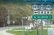
and into Amenia, where an overlap with NY 343
New York State Route 343
New York State Route 343 is a state highway located entirely within central Dutchess County, in the Hudson Valley region of the U.S. state of New York. It runs east–west from the intersection of NY 82 in the village of Millbrook to the Connecticut state line in the town of Amenia, where...
begins. The railroad line ends at Wassaic
Wassaic (Metro-North station)
The Wassaic Metro-North Railroad station serves the residents of Wassaic, New York as the northern terminal of the Harlem Line. Trains leave for New York City every two hours, and about every 30 minutes during rush hour...
, the most distant Metro-North station from the city in direct miles
As the crow flies
"As the crow flies" or beelining is an idiom for the shortest route between two points; the geodesic distance.An example is the great-circle distance between Key West and Pensacola, at either end of the U.S...
. Route 343 remains joined with Route 22 into the hamlet of Amenia, where it separates and heads towards state line. At the same junction, US 44
U.S. Route 44
U.S. Route 44 is an east–west United States highway that runs for 237 miles through four states in the Northeastern region of the United States. The western terminus is at U.S. Route 209 and New York State Route 55 in Kerhonkson, a hamlet in the Hudson Valley region of New York...
comes in from Millbrook
Millbrook, New York
Millbrook is a village in Dutchess County, New York, United States. It is often said to be a "low-key version of the Hamptons" and one of the wealthiest towns in New York State. Millbrook's estimated town population was 1,551 in 2008. Millbrook is located in the Hudson Valley, an hour and thirty...
to begin an overlap with Route 22. The valley opens up as the southern Taconics
Taconic Mountains
The Taconic Mountains or Taconic Range are a physiographic section of the larger New England province and part of the Appalachian Mountains, running along the eastern border of New York State and adjacent New England from northwest Connecticut to western Massachusetts, north to central western...
loom ahead. Shortly after crossing into the Town of North East
North East, New York
North East is a town in Dutchess County, New York, United States. The population was 3,002 at the 2000 census.The Town of North East is in the northeastern part of the county...
, the highway passes by the large Coleman Station Historic District
Coleman Station Historic District
The Coleman Station Historic District is located around the former New York Central Railroad Coleman's station in the Town of North East, New York, United States, a short distance south of the village of Millerton. It is a rural area including several large farms in the southeastern corner of the...
.
New York State Route 199
New York State Route 199 is a state highway located in the Hudson Valley of New York in the United States. It extends for from an interchange with U.S. Route 9W and US 209 north of Kingston to an intersection with US 44 and NY 22 southwest of Millerton...
at its eastern end, NY 22 and US 44 veer northeast into the small village of Millerton
Millerton, New York
Millerton is a village in Dutchess County, New York, United States. The population was 925 at the 2000 census. It is part of the Poughkeepsie–Newburgh–Middletown, NY Metropolitan Statistical Area as well as the larger New York–Newark–Bridgeport, NY-NJ-CT-PA Combined...
in the northern protrusion of Dutchess County's Oblong, an area once the subject of a boundary dispute between New York and Connecticut in the late 17th century. US 44 continues eastward towards Connecticut while NY 22 resumes its northward course into the shadow of the ridge ahead, where three states converge near the 2311 feet (704.4 m) Brace Mountain
Brace Mountain
Brace Mountain is the peak of a ridge in the southern Taconic Mountains, near the tripoint of the U.S. states of New York, Connecticut and Massachusetts...
, Dutchess County's highest, and Connecticut's highest point on Mount Frissell
Mount Frissell
Mount Frissell, , located on the border of southwest Massachusetts and northwest Connecticut, is a prominent peak of the Taconic Range. The peak and northern part of the mountain are located within Massachusetts. The southern slope of Mount Frissell is located within Connecticut and rises to the...
's southern slope. At another gentle curve, NY 22 slips into Columbia County
Columbia County, New York
Columbia County is a county located in the U.S. state of New York. As of the 2010 census, the population was 63,096. The county seat is Hudson. The name comes from the Latin feminine form of the name of Christopher Columbus, which was at the time of the formation of the county a popular proposal...
and the town of Ancram
Ancram, New York
Ancram, New York is a town in Columbia County, New York, United States. The population was 1,513 at the 2000 census. The town was named after a location in Scotland.The Town of Ancram is in the eastern part of the county.- History :...
. North of the county line, Massachusetts
Massachusetts
The Commonwealth of Massachusetts is a state in the New England region of the northeastern United States of America. It is bordered by Rhode Island and Connecticut to the south, New York to the west, and Vermont and New Hampshire to the north; at its east lies the Atlantic Ocean. As of the 2010...
becomes the state behind Alander Mountain
Alander Mountain
Alander Mountain, is a prominent peak of the south Taconic Mountains; it is located in southwest Massachusetts and adjacent New York. Part of the summit is grassy and open and part is covered with scrub oak and shrubs; the sides of the mountain are wooded with northern hardwood tree species....
and the other peaks visible to the east. The southernmost route from New York to the Massachusetts state line, NY 344
New York State Route 344
New York State Route 344 is a state highway located in Columbia County, New York, United States. The route is in length and serves primarily as an access road to the Bash Bish Falls state parks on both sides of the New York – Massachusetts border. The western terminus of NY 344 is...
, leaves for Bashbish Falls State Park
Bash Bish Falls
Bash Bish Falls, a waterfall in Bash Bish Falls State Park in the Taconic Mountains of southwestern Massachusetts , is the highest waterfall in the state...
at the hamlet of Copake Falls.
The next major junction is in Hillsdale
Hillsdale, New York
Hillsdale is a town in Columbia County, New York, United States. The population was 1,744 at the 2000 census.- History :The region was taken from the Town of Claverack in 1782. The Town of Hillsdale was established in 1788....
where NY 23
New York State Route 23
New York State Route 23 is an east–west state highway in the eastern portion New York in the United States. It extends for from an intersection with NY 26 in the Central New York town of Cincinnatus to the Massachusetts state line in the Berkshire Mountains, where it continues east as...
crosses NY 22 on its way to Catamount Ski Area
Catamount Ski Area
Catamount Ski Area is a ski resort located on Mount Fray of the Taconic Mountains in Hillsdale, New York and South Egremont, Massachusetts. It is one of the few remaining family-owned ski areas in New England.-History:...
, which straddles the New York–Massachusetts state line. At the hamlet of Green River, NY 71, the state's shortest two-digit route, begins at NY 22 heading east into Massachusetts. NY 22 then crosses into Austerlitz
Austerlitz, New York
Austerlitz is a town in Columbia County, New York, United States. The population was 1,453 at the 2000 census. The town was named after the Battle of Austerlitz.The Town of Austerlitz is in the east part of Columbia County.- History :Ellis, Capt...
, where the surrounding terrain becomes much more wooded and the valleys become narrower. In the center of town, East Hill Road offers a short detour to Steepletop
Steepletop
Steepletop, or Edna St. Vincent Millay House was the farmhouse home of Pulitzer Prize-winning poet Edna St. Vincent Millay and her husband Eugene Jan Boissevain, in Austerlitz, New York, United States. Her former home and gardens are maintained by the Edna St. Vincent Millay Society. It was...
, the farm where Edna St. Vincent Millay
Edna St. Vincent Millay
Edna St. Vincent Millay was an American lyrical poet, playwright and feminist. She received the Pulitzer Prize for Poetry, and was known for her activism and her many love affairs. She used the pseudonym Nancy Boyd for her prose work...
lived. A short distance later, NY 22 intersects with NY 203
New York State Route 203
New York State Route 203 is a state highway in the Capital District of New York in the United States. It begins at an intersection with NY 22 in the Columbia County hamlet of Austerlitz and ends at a junction with US 20 in the Rensselaer County village of Nassau. NY 203 was...
at its eastern end.
Route 22 then veers sharply to the northeast, resuming a northward direction only a short distance from the state line, a few hundred feet to the east. It then rounds a mountain and heads west, paralleling the New York State Thruway
New York State Thruway
The New York State Thruway is a system of limited-access highways located within the state of New York in the United States. The system, known officially as the Governor Thomas E. Dewey Thruway for former New York Governor Thomas E. Dewey, is operated by the New York State Thruway Authority and...
's Berkshire section (I-90
Interstate 90 in New York
Interstate 90 is a part of the Interstate Highway System that runs from Seattle, Washington, to Boston, Massachusetts. In the U.S. state of New York, I-90 extends from the Pennsylvania state line at Ripley to the Massachusetts state line at Canaan...
) for a mile. NY 980D (an unsigned reference route) leaves to the east, where it becomes Massachusetts Route 102 at the state line. After Thruway exit B3, NY 22 resumes its northerly heading. From here it intersects NY 295
New York State Route 295
New York State Route 295 is a state highway in Columbia County, New York, in the United States. It begins at an intersection with NY 66 in the village of Chatham and heads generally easterly to the Massachusetts border in the town of Canaan, where the road becomes that state's...
, then passes Queechy Lake
Queechy Lake
Queechy Lake is a lake in Canaan, Columbia County, New York. Situated near the Massachusetts state border, the lake is deep and contains a surface area of .The name comes from the Native American Mahican name Quis-sich-kook, of unknown meaning....
. NY 22 then straightens out to reach New Lebanon
New Lebanon, New York
New Lebanon is a town in Columbia County, New York, U.S., southeast of Albany. In 1910, 1,378 people lived in New Lebanon, New York. The population was 2,454 at the 2000 census.The town of New Lebanon is in the northeast part of Columbia County...
, where it intersects US 20
U.S. Route 20 in New York
U.S. Route 20 is a part of the U.S. Highway System that runs from Newport, Oregon, to Boston, Massachusetts. In the U.S. state of New York, US 20 extends from the Pennsylvania state line at Ripley to the Massachusetts state line in the Berkshire Mountains. US 20 is the longest...
. New York's longest east–west route (US 20) overlaps with its longest north–south route (NY 22) for a mile before the former continues to Pittsfield
Pittsfield, Massachusetts
Pittsfield is the largest city and the county seat of Berkshire County, Massachusetts, United States. It is the principal city of the Pittsfield, Massachusetts Metropolitan Statistical Area which encompasses all of Berkshire County. Its area code is 413. Its ZIP code is 01201...
and the latter returns to the border-paralleling course, which takes it into Rensselaer County
Rensselaer County, New York
Rensselaer County is a county in the U.S. state of New York. As of the 2010 census, the population was 159,429. Its name is in honor of the family of Kiliaen van Rensselaer, the original Dutch owner of the land in the area. Its county seat is Troy...
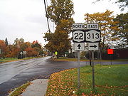
.
New York State Route 43
New York State Route 43 is a state highway in Rensselaer County, New York, United States. It extends for from Interstate 90 exit 8 in North Greenbush to the Massachusetts state line, where it continues into Williamstown as Massachusetts Route 43...
in Stephentown
Stephentown, New York
Stephentown is a town in Rensselaer County, New York, United States. The population was 2,873 at the 2000 census. The town is named after Stephen Van Rensselaer. The town is in the southeast corner of the county...
. North of that junction, it begins to run through a deep, isolated, lightly populated valley in the New York section of the Berkshires. Wide curves take the road through Berlin
Berlin, New York
Berlin is a town in Rensselaer County, New York, United States. The population was 1,901 at the 2000 census. The town is named after Berlin in Germany, although natives pronounce the name differently, with the accent on the first syllable....
, where Berlin Mountain
Berlin Mountain
Berlin Mountain, , is a prominent peak in the Taconic Mountains of western New England and adjacent New York. The summit and west side of the mountain are located in New York; the east side lies within Massachusetts. The mountain is a bald, notable for its grassy summit and expansive views of the...
, the highest peak in the state outside of the Catskills and Adirondacks, caps the eastern skyline. Route 22 trends further west, then back east to where NY 2
New York State Route 2
New York State Route 2 is a state highway in the Capital District of New York, United States. It extends from an interchange with Interstate 87 and NY 7 in the hamlet of Latham within the town of Colonie to the Massachusetts state line, where it continues to Boston as Route 2....
crosses via an overpass at Petersburgh
Petersburgh, New York
Petersburgh is a town located in the northeast section of Rensselaer County, New York, United States. The population was 1,563 at the 2000 census. The town was named after an early settler.- History :...
on its way to Petersburg Pass, the northernmost crossing of the New York-Massachusetts state line. The next road to head east from NY 22, NY 346
New York State Route 346
New York State Route 346 and Vermont Route 346 are short, adjoining state highways in the northeastern United States. Together, they extend for a combined through the towns of Petersburgh in Rensselaer County, New York, and Pownal in Bennington County, Vermont...
at North Petersburgh, enters Vermont
Vermont
Vermont is a state in the New England region of the northeastern United States of America. The state ranks 43rd in land area, , and 45th in total area. Its population according to the 2010 census, 630,337, is the second smallest in the country, larger only than Wyoming. It is the only New England...
.
Shortly afterward, the highway descends gently from the Berkshires to meet another major state road, NY 7
New York State Route 7
New York State Route 7 is a 180-mile long New York State Highway that runs from the New York/Pennsylvania border south of Binghamton, New York to the New York/Vermont border east of Hoosick. Most of the road runs along the Susquehanna Valley, closely paralleling Interstate 88 throughout...
, and overlaps with it for a short distance. Two miles after that concurrency ends, NY 22 follows the upper Hoosic River
Hoosic River
The Hoosic River, also known as the Hoosac, the Hoosick and the Hoosuck , is a tributary of the Hudson River in the northeastern United States. The different spellings are the result of varying transliterations of the river's original Algonquian name...
to Hoosick Falls
Hoosick Falls, New York
Hoosick Falls is a village in Rensselaer County, New York, United States. The population was 3,182 at the 2010 census, a decline of 254 since 2000. During its peak around 1900, the village had a population of about 7,000...
, the first village it has passed through since Millerton. There are no other state routes here, but after another 2 miles (3.2 km), at North Hoosick, NY 67
New York State Route 67
New York State Route 67 is an east–west state highway in eastern New York in the United States. The western terminus of the route is at an intersection with NY 5 in the town of St. Johnsville...
comes in from the east and the two roads overlap as they leave Rensselaer County.
Washington County
Almost immediately after the joined roads cross the county line, NY 67 splits off to the west, crossing the Hoosick back into Rensselaer County, while NY 22 straightens out again to go due north. After 4 miles (6 km), it reaches CambridgeCambridge (village), New York
Cambridge is a village in Washington County, New York, United States. The population was 1,925 at the 2000 census. The village of Cambridge is partly in the town of Cambridge and partly in the town of White Creek...
, where NY 313
New York State Route 313
New York State Route 313 is a state highway in New York State. It begins at NY 22 in Cambridge, and intersects with two county routes on its journey from Cambridge to the state line in Salem. Once in Salem, the route crosses the Vermont border, entering the town of Arlington...
forks off to the east. In the middle of town, NY 372
New York State Route 372
New York State Route 372 is an east–west state highway in southern Washington County, New York, in the United States. It extends for just under from an intersection with NY 22 in the village of Cambridge to a junction with NY 29 in the village of Greenwich...
, a local connector to Greenwich, ends.
Appalachian Mountains
The Appalachian Mountains #Whether the stressed vowel is or ,#Whether the "ch" is pronounced as a fricative or an affricate , and#Whether the final vowel is the monophthong or the diphthong .), often called the Appalachians, are a system of mountains in eastern North America. The Appalachians...
and the Adirondacks
Adirondack Mountains
The Adirondack Mountains are a mountain range located in the northeastern part of New York, that runs through Clinton, Essex, Franklin, Fulton, Hamilton, Herkimer, Lewis, Saint Lawrence, Saratoga, Warren, and Washington counties....
. Beyond NY 29
New York State Route 29
New York State Route 29 is a state highway extending for across the eastern portion of the U.S. state of New York. The western terminus of the route is at NY 28 and NY 169 in Middleville, Herkimer County. The eastern terminus of the route is at NY 22 just south of Salem,...
's eastern terminus at Greenwich Junction, Route 22 heads eastward again through 18 miles (29 km) of countryside until, just before reaching Granville
Granville (village), New York
Granville is a village in Washington County, New York, United States. It is part of the Glens Falls Metropolitan Statistical Area. The village population was 2,644 at the 2000 census....
, it comes within 0.5 miles (804.7 m) of the state line, the closest it has come to that boundary since Austerlitz. At the village's south end, NY 22 intersects NY 149
New York State Route 149
New York State Route 149 is an east–west state highway that runs for through the Capital District of New York in the United States. It begins at exit 20 on the Adirondack Northway in the Warren County town of Queensbury and intersects U.S...
and the two routes overlap for several blocks until NY 149 begins its short journey to Vermont. Just north of Granville, the first of NY 22's two suffixed routes, NY 22A
New York State Route 22A
New York State Route 22A is a short north–south New York State Route located within Washington County. Its northern terminus is located in the town of Hampton at the Vermont state line, where it becomes Vermont Route 22A...
, begins its route running closely parallel to the state line and then into Vermont, where it becomes Vermont Route 22A, paralleling the parent route for some distance on the other side of the state line.
Immediately after this junction, NY 22 begins a long curve away from the state line that has it running due west at the end of NY 40
New York State Route 40
New York State Route 40 is a north–south state highway in eastern New York, United States. It is long and runs from NY 7 in the city of Troy north to NY 22 in the town of Granville. NY 40 also passes through the villages of Schaghticoke and Argyle and enters the vicinity of...
in North Granville. It heads northwest a little further until, after passing between Great Meadows
Great Meadow Correctional Facility
Great Meadow Correctional Facility is a maximum security prison in New York in the USA. The prison is in Comstock, a hamlet right outside of Fort Ann, in Washington County, New York. As of September 3, 2008 it was home to 1,663 inmates...
and Washington
Washington Correctional Facility
Washington Correctional Facility is a medium security correctional facility that is located in Comstock, a hamlet of Fort Ann, New York in Washington County, New York. It is designated for confinement of males age 16 and older. The facility offers volunteer and counciling services, and educational...
state prisons, it reaches US 4
U.S. Route 4 in New York
U.S. Route 4 is a part of the U.S. Highway System that runs from East Greenbush, New York, to Portsmouth, New Hampshire. In the U.S. state of New York, US 4 extends from an intersection with US 9 and US 20 in East Greenbush to the Vermont state line northeast of Whitehall...
and turns right to join it, resuming its northward course. The overlap with US 4, one of the few along Route 22 that pairs it with another north–south route, lasts for seven miles (11 km) along the base of the Adirondack foothills between the low country and Lake George
Lake George (New York)
Lake George, nicknamed the Queen of American Lakes, is a long, narrow oligotrophic lake draining northwards into Lake Champlain and the St. Lawrence River Drainage basin located at the southeast base of the Adirondack Mountains in northern New York, U.S.A.. It lies within the upper region of the...
, before ending in Whitehall
Whitehall (village), New York
Whitehall is a village located in the town of Whitehall in Washington County, New York, USA. It is part of the Glens Falls Metropolitan Statistical Area...
, where US 4 leaves to assume the east–west course it takes across northern New England.
Adirondack Park and Lake Champlain
As NY 22 bends westward after leaving Whitehall, it rounds the north end of the ridge to the west, offering views into Vermont. Once again the Vermont state line is very near NY 22, but now it is separated from New York by water instead of land. The stream at the bottom of this valley, surrounded by the low lying Drowned Lands flood plain, is the inflow for Lake ChamplainLake Champlain
Lake Champlain is a natural, freshwater lake in North America, located mainly within the borders of the United States but partially situated across the Canada—United States border in the Canadian province of Quebec.The New York portion of the Champlain Valley includes the eastern portions of...
. The lake's South Bay, which the road crosses immediately after this turn, is also the Blue Line
Blue Line (New York State)
The Blue Line is the term used in New York state for the boundaries of the Adirondack and Catskill parks, within which can be found the state's Forest Preserve...
. Route 22 has now entered Adirondack Park, the 6100000 acres (24,685.8 km²) Forest Preserve
Forest Preserve (New York)
New York's Forest Preserve is all the land owned by the state within the Adirondack and Catskill parks, managed by its Department of Environmental Conservation. These properties are required to be kept "forever wild" by Article 14 of the state constitution, and thus enjoy the highest degree of...
and National Historic Landmark
National Historic Landmark
A National Historic Landmark is a building, site, structure, object, or district, that is officially recognized by the United States government for its historical significance...
, and the largest state-level protected area
Protected area
Protected areas are locations which receive protection because of their recognised natural, ecological and/or cultural values. There are several kinds of protected areas, which vary by level of protection depending on the enabling laws of each country or the regulations of the international...
in any state. Within the park, NY 22 mainly follows the lakeshore, closer to some of its more populated areas.
It continues along the hillside of Black Mountain, Washington County's highest peak, as it meanders north on the narrowing isthmus
Isthmus
An isthmus is a narrow strip of land connecting two larger land areas usually with waterforms on either side.Canals are often built through isthmuses where they may be particularly advantageous to create a shortcut for marine transportation...
between Lakes Champlain and George. Near the northern end, it crosses the Essex County
Essex County, New York
Essex County is a county located in the U.S. state of New York. As of the 2010 census, the population was 39,370. Its name is from the English county of Essex. Its county seat is Elizabethtown...
line. Two miles later, it reaches the first settlement along its length within the Adirondack Park, Ticonderoga
Ticonderoga, New York
Ticonderoga is a town in Essex County, New York, USA. The population was 5,167 at the 2000 census. The name comes from the Mohawk tekontaró:ken, meaning "it is at the junction of two waterways"....
. The highway skirts the northeastern edge of the village, the site of key battles
Battle of Ticonderoga
Battle of Ticonderoga may refer to:*Battle of Ticonderoga or Battle of Carillon, an unsuccessful British attack on French*Battle of Ticonderoga , a British approach that forced a small French garrison to withdraw...
in both the French and Indian
French and Indian War
The French and Indian War is the common American name for the war between Great Britain and France in North America from 1754 to 1763. In 1756, the war erupted into the world-wide conflict known as the Seven Years' War and thus came to be regarded as the North American theater of that war...
and Revolutionary
American Revolutionary War
The American Revolutionary War , the American War of Independence, or simply the Revolutionary War, began as a war between the Kingdom of Great Britain and thirteen British colonies in North America, and ended in a global war between several European great powers.The war was the result of the...
Wars, as NY 74
New York State Route 74
New York State Route 74 and Vermont Route 74 are adjoining state highways in the northeastern United States, connected by one of the last remaining cable ferries in North America. Together they extend for through Essex County, New York, and Addison County, Vermont...
comes in from the ferry to the east. This overlap lasts for almost two miles (3 km) until NY 74 goes straight ahead at the intersection with NY 9N
New York State Route 9N
New York State Route 9N is a north–south state highway in northeastern New York, United States. It extends from an intersection with U.S. Route 9 , NY 29, and NY 50 in the city of Saratoga Springs to a junction with US 9 and NY 22 in the Clinton County village of...
, while NY 22 turns right to join NY 9N, the longest suffixed route in the state, and return to its northbound orientation.
At first, Routes 22 and 9N veer west, away from the lake, but then return to its shoreline to avoid a nearby mountain, just before Crown Point
Crown Point, New York
Crown Point is a town in Essex County, New York, USA. The population was 2,119 at the 2000 census. The name of the town is a direct translation of the original French name, "Point au Chevalure."...
. NY 185
New York State Route 185
New York State Route 185 was a state highway located within St. Lawrence County in the North Country of New York in the United States. Although the route followed a mostly north–south alignment, it was considered an east–west highway by the New York State Department of Transportation...
, a small connector road, runs from 9N and 22 along the peninsula to become VT 17
Vermont Route 17
Vermont Route 17 is a long state highway in western Vermont, United States. The temporary western terminus is at the Lake Champlain shoreline in Addison just west of its junction with VT 125. The eastern terminus is at VT 100 in Waitsfield. VT 17 was initially much shorter than it is today,...
. They remain close to the widening lake for the next 15 miles (24 km) through Port Henry
Port Henry, New York
Port Henry is a village in Essex County, New York, United States. The population was 1,152 at the 2000 census.The Village of Port Henry lies on the east side of the Town of Moriah and is approximately one hour's drive south of Plattsburgh...
to Westport
Westport, New York
Westport is a town in Essex County, New York, United States overlooking Lake Champlain. The population was 1,362 at the 2000 census.The Town of Westport is on the eastern border of the county and is south of Plattsburgh and south of Montreal. Westport is inside the Adirondack Park.Westport is...
, where 9N leaves heading west for Elizabethtown
Elizabethtown, New York
Elizabethtown is a town in Essex County, New York, United States. The population was 1,315 at the 2000 census. The county seat of Essex County is a hamlet also called Elizabethtown. The name is derived from Elizabeth Gilliland, the wife of an early settler....
. Beyond that junction, Route 22 again turns inland, going through the easy pass around Split Rock Mountain. At Bouquet, it makes an abrupt right turn to go due east back to the lakeshore and ferry landing at Essex
Essex, New York
Essex is a town in Essex County, New York, United States overlooking Lake Champlain. The population was 713 at the 2000 census. The town is named after locations in England.The Town of Essex is on the eastern edge of the county...
.
Route 22 heads to the northwest again, away from the lake, until it heads west and intersects US 9 in the town of Chesterfield
Chesterfield, New York
Chesterfield is a town in Essex County, New York, United States. The population was 2,409 at the 2000 census. The name possibly is from a location in New England....
, the other major north–south surface route up the state's eastern side. Routes 22 and 9 join together, closely parallel to the Adirondack Northway (I-87), the only other route in the state to directly connect New York City with Canada. The three routes, spread over many miles in the southern part of the state, run through a narrow corridor for two miles (3 km) until Routes 9 and 22 veer east again toward Keeseville
Keeseville, New York
Keeseville is a village in both Clinton County, New York and in Essex County, New York in the United States. The population was 1,815 at the 2010 census. The village is named after the Keese family....
.
Here, Route 9N ends and Routes 9 and 22 separate. The two will exchange corridors, with US 9 following the lake shore line while NY 22 remains mostly inland. NY 22 enters Clinton County
Clinton County, New York
Clinton County is a county located in the U.S. state of New York. As of the 2010 census, the population was 82,128. Its name is in honor of the first Governor of New York as a state, George Clinton. Its county seat is Plattsburgh.-History:...
just north of Keeseville, and then leaves Adirondack Park 2 miles (3.2 km) beyond at the Peru
Peru, New York
Peru is a town in Clinton County in the U.S. state of New York. The population was 6,998 at the 2010 census. The town was named Peru because its mountainous nature suggested that country....
town line.
Clinton County
Just south of the hamlet of PeruPeru (CDP), New York
Peru is a hamlet within the Town of Peru in Clinton County in the U.S. state of New York. The population was 1,591 at the 2010 census.The community is located at the junction of Route 22 and Route 22B....
, the short NY 442
New York State Route 442
New York State Route 442 is a state highway located within the town of Peru in Clinton County, New York, in the United States. It is an east–west highway that connects the hamlet of Peru with the Adirondack Northway . The western terminus of the route is at an intersection with...
terminates at Route 22. In the hamlet itself, after the Little Au Sable River crossing, NY 22's other suffixed route, NY 22B, branches off further inland. NY 22 continues north of Peru, and returns to the Northway's side again in a mile. After another five miles (8 km), it has its first exit on the Northway near the now-closed Plattsburgh Air Force Base
Plattsburgh Air Force Base
Plattsburgh Air Force Base is a former United States Air Force Strategic Air Command base covering 3,447 acres in the extreme northeast corner of New York, 20 miles south of the Canadian border...
. It continues northeastward, crossing the Saranac River
Saranac River
Saranac River is an river in the U.S. state of New York. In its upper reaches is a region of mostly flat water and lakes. The river has more than three dozen source lakes and ponds north of Upper Saranac Lake; the highest is Mountain Pond on Long Pond Mountain...
into Plattsburgh
Plattsburgh (city), New York
Plattsburgh is a city in and county seat of Clinton County, New York, United States. The population was 19,989 at the 2010 census. The population of the unincorporated areas within the Town of Plattsburgh was 11,870 as of the 2010 census; making the population for the immediate, urban Plattsburgh,...
, the first city and most populous community NY 22 has passed through since White Plains.
NY 22 runs along South Catherine Street for a few blocks, then divides into one-way couplets for the first time since Westchester County, with northbound traffic moving a block to the east to follow Oak Street, while southbound traffic comes down North Catherine Street. It parallels US 9 for a couple of blocks, intersecting NY 3
New York State Route 3
New York State Route 3 is a major east–west state highway in New York, United States, that connects central New York to the North Country region near the Canadian border via Adirondack Park. The route extends for between its western terminus at an intersection with NY 104A in the Cayuga...
(Cornelia Street) just a block west of its eastern terminus at that highway. After Boynton Avenue, the separate streets reunite and turns northwest just before it has its second and final exit with the Northway. Just after the exit, NY 374
New York State Route 374
New York State Route 374 is a state highway in the North Country of New York in the United States. The route follows a generally northwest to southeast progression; however, the portion of the route within Franklin County runs north–south and is signed in the same manner...
begins along the westbound route as NY 22 turns to the north once again.
The highway follows the railroad tracks into Beekmantown
Beekmantown, New York
Beekmantown is a town in Clinton County, New York, United States. The population was 5,545 at the 2010 census. The town name is that of William Beekman, an original landowner....
until it bears left at a fork, trending further west to Beekmantown Corners, where another short local road, NY 456
New York State Route 456
New York State Route 456 is a short state highway located entirely within the town of Beekmantown in Clinton County, New York, in the United States...
, comes to its western end. After crossing into the next town, Chazy
Chazy, New York
Chazy is a town in northeastern Clinton County, New York, in the United States. The population was 4,284 at the 2010 census. The closest city is Plattsburgh, to the south. Chazy is from Canada. The zip code is 12921 and it is in area code 518.- History:...
, NY 22 bears left again at another fork to drift further to the west. The terrain around the road becomes increasingly wooded, with long unbroken stretches of pine, in the northern portion of the town. This is briefly broken at another western terminus of a short local road, NY 191
New York State Route 191
New York State Route 191 is a short county-maintained state highway located north of Adirondack Park in Clinton County, New York, United States. The route is co-designated by the county highway department as County Route 23 and heads from an intersection with NY 22 in the hamlet of...
, in the hamlet of Sciota.
Route 22 continues past Sciota in a fairly straight north-northwesterly course through more woods with small home and farm clearings. Those yield to mostly fields just before the Great Chazy River, after which NY 22 enters the hamlet of Mooers
Mooers (CDP), New York
Mooers is a hamlet in Clinton County, New York, USA. The population was 442 at the 2010 census.The community of Mooers is in the Town of Mooers near the northern border of New York State and the Canadian province of Quebec....
. As signed, NY 22 comes to an end upon intersecting US 11
U.S. Route 11 in New York
U.S. Route 11 is a part of the U.S. Highway System that runs from New Orleans, Louisiana, to the Canadian border at Rouses Point, New York...
; however, it officially overlaps with US 11 west to Hemmingford Road, where it turns north to follow Hemmingford Road north to the Canadian border. The highway continues north into the province of Quebec
Quebec
Quebec or is a province in east-central Canada. It is the only Canadian province with a predominantly French-speaking population and the only one whose sole official language is French at the provincial level....
as Route 219
Quebec Route 219
Route 219 is a provincial highway located in the Montérégie region of Quebec south of Montreal. It starts at the border south of Hemmingford and ends in Saint-Jean-sur-Richelieu....
.
Old roads
The road from the modern-day Bronx (then part of Westchester County) through White Plains to Bedford and points north was originally an old Indian path. This path was later used and widened by the first European settlers. During colonial times, the road was known as "the road to Bedford and Vermont". Further north, near Lake Champlain, the route now used by Route 22 was used by the St. Francis Indians of Canada as they went south to find warmer fishing areas. The old road was also used heavily during the American RevolutionAmerican Revolution
The American Revolution was the political upheaval during the last half of the 18th century in which thirteen colonies in North America joined together to break free from the British Empire, combining to become the United States of America...
to transport iron south from the mines in the Adirondacks.
Once White Plains
White Plains, New York
White Plains is a city and the county seat of Westchester County, New York, United States. It is located in south-central Westchester, about east of the Hudson River and northwest of Long Island Sound...
became the county seat of Westchester
Westchester County, New York
Westchester County is a county located in the U.S. state of New York. Westchester covers an area of and has a population of 949,113 according to the 2010 Census, residing in 45 municipalities...
in 1759, the road between this village and the city of New York (then encompassing only Manhattan
Manhattan
Manhattan is the oldest and the most densely populated of the five boroughs of New York City. Located primarily on the island of Manhattan at the mouth of the Hudson River, the boundaries of the borough are identical to those of New York County, an original county of the state of New York...
) became an important route and was established as the White Plains Post Road. Before 1797, the main road heading to points north and east out of Manhattan went via Kingsbridge
Kingsbridge, Bronx
Kingsbridge is a working class residential neighborhood geographically located in the northwest Bronx in New York City. The neighborhood is part of Bronx Community Board 8. Its boundaries are Van Cortlandt Park to the north, Goulden Avenue to the east, West 225th Street to the south, and Irwin...
along the old Boston Post Road
Boston Post Road
The Boston Post Road was a system of mail-delivery routes between New York City and Boston, Massachusetts that evolved into the first major highways in the United States.The three major alignments were the Lower Post Road The Boston Post Road was a system of mail-delivery routes between New York...
. A new bridge over the Harlem River
Harlem River
The Harlem River is a navigable tidal strait in New York City, USA that flows 8 miles between the Hudson River and the East River, separating the boroughs of Manhattan and the Bronx...
(the original Harlem Bridge) was opened in 1797, shortening the route out of Manhattan. This also relocated the Boston and White Plains Post Roads to a new alignment along Third Avenue and Boston Road. The White Plains Post Road separated from the Boston Post Road in Bronxdale, with the road to Boston heading east and the road to White Plains heading north. The old White Plains Post Road roughly followed the alignment of modern-day White Plains Road, which was laid out in 1863. (The original post road was to the east of the modern-day avenue). The White Plains Post Road continued north through Olinville, Wakefield, and Mount Vernon
Mount Vernon, New York
Mount Vernon is a city in Westchester County, New York, United States. It lies on the border of the New York City borough of The Bronx.-Overview:...
, where the route shifted east to modern-day White Plains Post Road, going through Bronxville
Bronxville, New York
Bronxville is an affluent village within the town of Eastchester, New York, in the United States. It is a suburb of New York City, located approximately north of midtown Manhattan in southern Westchester County. At the 2010 census, Bronxville had a population of 6,323...
and Scarsdale
Scarsdale, New York
Scarsdale is a coterminous town and village in Westchester County, New York, United States, in the northern suburbs of New York City. The Town of Scarsdale is coextensive with the Village of Scarsdale, but the community has opted to operate solely with a village government, one of several villages...
to White Plains
White Plains, New York
White Plains is a city and the county seat of Westchester County, New York, United States. It is located in south-central Westchester, about east of the Hudson River and northwest of Long Island Sound...
.
The stretch from Salem to the Vermont
Vermont
Vermont is a state in the New England region of the northeastern United States of America. The state ranks 43rd in land area, , and 45th in total area. Its population according to the 2010 census, 630,337, is the second smallest in the country, larger only than Wyoming. It is the only New England...
border in Granville
Granville, New York
Granville is a town on the eastern border of Washington County, New York, United States. It is part of the Glens Falls Metropolitan Statistical Area...
was part of the old Northern Turnpike, which began in Lansingburgh
Lansingburgh, New York
Lansingburgh was the first chartered village in Rensselaer County, New York, USA and was settled around 1763. The name is from Abraham Lansing, an early settler, combined with the Scottish word burgh....
and went along modern-day Route 40
New York State Route 40
New York State Route 40 is a north–south state highway in eastern New York, United States. It is long and runs from NY 7 in the city of Troy north to NY 22 in the town of Granville. NY 40 also passes through the villages of Schaghticoke and Argyle and enters the vicinity of...
. The Northern Turnpike was chartered on April 1, 1799.
Public ownership
In 1868, the New York State LegislatureNew York Legislature
The New York State Legislature is the term often used to refer to the two houses that act as the state legislature of the U.S. state of New York. The New York Constitution does not designate an official term for the two houses together...
formed a commission "to regulate, grade, widen, gravel, and improve the old White Plains Post Road", which was amended in 1870 to "macadamize the road" between Mount Vernon and White Plains. The post road south of Mount Vernon, which was part of New York City, was later widened between 1902 and 1908.
State highway
State highway
State highway, state road or state route can refer to one of three related concepts, two of them related to a state or provincial government in a country that is divided into states or provinces :#A...
s were first formally defined by the state legislature in 1909 and given numeric designations, although these initial designations were not publicly signed. Portions of modern Route 22 were defined as part of legislative routes 1 and 22. Legislative route 1 went from the New York City line north along the White Plains Post Road to White Plains, then detoured to Harrison (via Westchester Avenue), before proceeding north to Armonk
Armonk, New York
Armonk is a hamlet and census-designated place located in the town of North Castle in Westchester County, New York. As of the 2010 census, the CDP population was 4,330....
(via modern NY 120
New York State Route 120
New York State Route 120 is a state highway in southern Westchester County, New York, United States. It begins in the city of Rye at an intersection with U.S. Route 1 and runs for about north to the hamlet of Millwood, where it ends at a junction with NY 100...
). Legislative route 1 continued north along modern NY 22 to Austerlitz, where it then turned northwest to Valatie (via modern NY 203
New York State Route 203
New York State Route 203 is a state highway in the Capital District of New York in the United States. It begins at an intersection with NY 22 in the Columbia County hamlet of Austerlitz and ends at a junction with US 20 in the Rensselaer County village of Nassau. NY 203 was...
), then followed US 9 to Albany. Legislative route 22 had two segments. The southern segment began in Troy, following NY 7
New York State Route 7
New York State Route 7 is a 180-mile long New York State Highway that runs from the New York/Pennsylvania border south of Binghamton, New York to the New York/Vermont border east of Hoosick. Most of the road runs along the Susquehanna Valley, closely paralleling Interstate 88 throughout...
to Hoosick, then went north along modern NY 22 up to Putnam Station (south of Ticonderoga).
Route 22 designation
In 1924, New York signed several major state roads with route numbers. Most of Legislative route 1 was designated as NY 22, but with a direct route between White Plains and Armonk. Also, instead of continuing to Valatie, NY 22 initially ended at HillsdaleHillsdale, New York
Hillsdale is a town in Columbia County, New York, United States. The population was 1,744 at the 2000 census.- History :The region was taken from the Town of Claverack in 1782. The Town of Hillsdale was established in 1788....
(at the intersection with NY 23
New York State Route 23
New York State Route 23 is an east–west state highway in the eastern portion New York in the United States. It extends for from an intersection with NY 26 in the Central New York town of Cincinnatus to the Massachusetts state line in the Berkshire Mountains, where it continues east as...
). By 1929, the road to Valatie had been improved and NY 22 was extended to US 9, with a length of 139 miles (224 km). The middle section of modern NY 22 was designated in 1924 as NY 24, running for 75 miles (121 km) from Stephentown
Stephentown, New York
Stephentown is a town in Rensselaer County, New York, United States. The population was 2,873 at the 2000 census. The town is named after Stephen Van Rensselaer. The town is in the southeast corner of the county...
to Comstock. The portion of modern NY 22 north of Whitehall remained unnumbered in 1924 but gained a designation in 1925 when NY 30, a route assigned in 1924 that linked Mechanicville
Mechanicville, New York
Mechanicville is a city in Saratoga County, New York, United States. The population is 5,196 as of the 2010 census. It is the smallest city by area in the state. The name is derived from the occupations of early residents....
to Whitehall, was extended north from Whitehall to the Canadian border north of Mooers
Mooers (CDP), New York
Mooers is a hamlet in Clinton County, New York, USA. The population was 442 at the 2010 census.The community of Mooers is in the Town of Mooers near the northern border of New York State and the Canadian province of Quebec....
. In the 1930 renumbering, the NY 24 and NY 30 designations were both reassigned elsewhere. The NY 22 designation was extended north along old NY 24 and NY 30, incorporating newly improved roads between Austerlitz and Stephentown, resulting in a route length of 370 miles (595 km). The segment of old NY 22 between Austerlitz and Valatie was renumbered to NY 203
New York State Route 203
New York State Route 203 is a state highway in the Capital District of New York in the United States. It begins at an intersection with NY 22 in the Columbia County hamlet of Austerlitz and ends at a junction with US 20 in the Rensselaer County village of Nassau. NY 203 was...
.
In December 1934, at the insistence of the Automobile Club of New York, several numbered routes were extended and signed within New York City
New York City
New York is the most populous city in the United States and the center of the New York Metropolitan Area, one of the most populous metropolitan areas in the world. New York exerts a significant impact upon global commerce, finance, media, art, fashion, research, technology, education, and...
, with NY 22 being one of these routes. NY 22 was extended south from the Mount Vernon line in the Bronx along White Plains Road
White Plains Road
White Plains Road is a major thoroughfare which runs the length of the Bronx, New York, from Castle Hill and Clason Point in the south to Wakefield in the north, where it crosses the city line and becomes West 1st Street of Mount Vernon, New York. The Bronx River Parkway lies to its west and...
, then it shifted via East 233rd Street
East 233rd Street (Bronx)
East 233rd Street is one of the major thoroughfares of the Bronx. The road is 3 miles long and stretches from U.S. Route 1 in the Eastchester section of the Bronx to the Major Deegan Expressway in Woodlawn . The road changes names from East 233rd Street to Pinkley Avenue after the...
to Webster Avenue
Webster Avenue
Webster Avenue is one of the longest thoroughfares in the Bronx. It stretches for 5.8 miles from Melrose to Woodlawn . The road starts at an intersection with Melrose Avenue, East 165th Street, Brook Avenue and Park Avenue in Melrose, ending at Nereid Avenue and East 240th Street in the town of...
until Fordham Road
Fordham Road
Fordham Road is a major street in The Bronx borough of New York City. It runs east-west from the Harlem River to Bronx Park.This street runs through the neighborhood of University Heights, divides Fordham from Fordham-Bedford and finally runs along the northern border of Belmont...
(US 1). From Fordham Road, it continued south along the Grand Concourse
Grand Concourse (Bronx)
The Grand Concourse is a major thoroughfare in the borough of the Bronx in New York City...
(overlapped with NY 100
New York State Route 100
New York State Route 100 is a major north–south state highway in Westchester County, New York, in the United States. It begins parallel to Interstate 87 at a junction with the Cross County Parkway in the city of Yonkers and runs through most of the length of the county via the city of...
), crossing into Manhattan via East 149th Street to the 145th Street Bridge
145th Street Bridge
The 145th Street Bridge, located in New York City, USA, is a four-lane swing bridge that crosses the Harlem River, connecting 145th Street and Lenox Avenue in Manhattan with East 149th Street and River Avenue in the Bronx. It once carried northbound New York State Route 22 and New York State Route...
. In Manhattan, the NY 22/100 pair continued south along Lenox Avenue, 110th Street
110th Street (Manhattan)
110th Street is a street in the New York City borough of Manhattan. It is commonly known as the boundary between Harlem and Central Park, along which it is known as Central Park North. In the west, it is also known as Cathedral Parkway....
, Fifth Avenue, 96th Street
96th Street (Manhattan)
96th Street is a major two-way street in East Harlem and the Upper West Side, which is a part of the New York City borough of Manhattan, running from the East River at the FDR Drive to the Henry Hudson Parkway at the Hudson River...
, and Park Avenue
Park Avenue (Manhattan)
Park Avenue is a wide boulevard that carries north and southbound traffic in New York City borough of Manhattan. Through most of its length, it runs parallel to Madison Avenue to the west and Lexington Avenue to the east....
, ending at Houston Street (NY 1A
New York State Route 1A
New York State Route 1A was a state highway in New York City, running from the Holland Tunnel to U.S. Route 1 . It existed from 1934, when routes were first marked in New York City, until the 1960s.-History:...
). By 1941, the alignment within Mount Vernon was shifted east to use Columbus Avenue and South 3rd Avenue (current NY 22), continuing its route to New York City via East 233rd Street as before. On January 1, 1970, the NY 22 designation was removed from Manhattan and most of the Bronx, and the short piece remaining in the city was realigned to meet US 1 at its current southern terminus.
U.S. Route 7
In the original plan for the U.S. Highway System, as approved by the Bureau of Public Roads in November 1926, US 7U.S. Route 7
U.S. Route 7 is a north–south United States highway in western New England that runs for from Norwalk, Connecticut, to Highgate, Vermont. The highway's southern terminus is at Interstate 95 in Norwalk, Connecticut...
was defined as beginning in New York City and designated on the alignment of NY 22 to Amenia, where it shifted northeast into Sharon, Connecticut
Sharon, Connecticut
Sharon is a town located in Litchfield County, Connecticut, in the northwest corner of the state. It is bounded on the north by Salisbury, on the east by the Housatonic River, on the south by Kent, and on the west by Dutchess County, New York...
to use old New England Route 4 through Massachusetts and Vermont all the way to the Canadian border. Apparently New York State did not approve this plan, and by mid-1927 the official route log published by AASHO (now known as AASHTO) had been amended so that the southern end of US 7 began in Norwalk, Connecticut
Norwalk, Connecticut
Norwalk is a city in Fairfield County, Connecticut, United States. According to the 2010 U.S. Census, the population of the city is 85,603, making Norwalk sixth in population in Connecticut, and third in Fairfield County...
instead.
State Route 9N concurrency
In the 1930 renumbering of state highways in New York, the stretch from Ticonderoga to Keeseville (now concurrent with NY 9NNew York State Route 9N
New York State Route 9N is a north–south state highway in northeastern New York, United States. It extends from an intersection with U.S. Route 9 , NY 29, and NY 50 in the city of Saratoga Springs to a junction with US 9 and NY 22 in the Clinton County village of...
) was designated solely as Route 22. The north end of NY 47 was also located at an intersection with Route 22 in Ticonderoga. At Westport, NY 22 connected to NY 195, an east–west highway leading to Elizabethtown. At the time, Route 9N only stretched from Elizabethtown to Keeseville. NY 9N was extended southward to Lake George ca. 1936, supplanting NY 47 and NY 195 and becoming concurrent with NY 22 between Ticonderoga and Westport.
NY 8 originally extended eastward from Hague to a ferry across Lake Champlain
Lake Champlain
Lake Champlain is a natural, freshwater lake in North America, located mainly within the borders of the United States but partially situated across the Canada—United States border in the Canadian province of Quebec.The New York portion of the Champlain Valley includes the eastern portions of...
at Putnam
Putnam, New York
Putnam is a town in northern Washington County, New York, United States. It is part of the Glens Falls Metropolitan Statistical Area. The town population was 645 at the 2000 census...
when it was assigned as part of the renumbering. In between the two locations, the route utilized modern NY 9N, Montcalm Street, NY 22, and Wrights Ferry and Wrights Roads. It was realigned in the early 1930s to continue east from Ticonderoga on what is now NY 74
New York State Route 74
New York State Route 74 and Vermont Route 74 are adjoining state highways in the northeastern United States, connected by one of the last remaining cable ferries in North America. Together they extend for through Essex County, New York, and Addison County, Vermont...
to another ferry across the lake. Ca. 1934, NY 8 was altered again to follow NY 22 north from Ticonderoga to Crown Point, where it turned off the highway onto Bridge Road (now NY 185
New York State Route 185
New York State Route 185 was a state highway located within St. Lawrence County in the North Country of New York in the United States. Although the route followed a mostly north–south alignment, it was considered an east–west highway by the New York State Department of Transportation...
). Route 8 remained intact along this routing until ca. 1968, when Route 8 was truncated southwestward to NY 9N in Hague
Hague, New York
Hague is a town in northeastern Warren County, New York, United States located on the scenic Lake George. It is part of the Glens Falls Metropolitan Statistical Area. The population was 854 at the 2000 census...
.
Realignments
Over the course of many years, several sections of NY 22 were straightened, realigned to new roads, or both. Some old alignments are still either county-maintained or state-maintained. Several of these are in Dutchess CountyDutchess County, New York
Dutchess County is a county located in the U.S. state of New York, in the state's Mid-Hudson Region of the Hudson Valley. The 2010 census lists the population as 297,488...
. In Dover Plains
Dover Plains, New York
Dover Plains is a hamlet in Dutchess County, New York, United States. The population was 1,996 at the 2000 census...
, the southern leg of NY 22's junction with NY 343
New York State Route 343
New York State Route 343 is a state highway located entirely within central Dutchess County, in the Hudson Valley region of the U.S. state of New York. It runs east–west from the intersection of NY 82 in the village of Millbrook to the Connecticut state line in the town of Amenia, where...
is maintained by the state as NY 980G, a reference route. To the north in the town of Amenia
Amenia (town), New York
Amenia is a town in Dutchess County, United States. New York, United States. The population was 4,048 at the 2000 census. The name is derived from the Latin word, amoena, which means "pleasant to the eye."...
, a 4.03 miles (6.49 km) long loop off NY 22 between Wassaic
Wassaic, New York
Wassaic is a hamlet in the Town of Amenia, Dutchess County, New York in the United States.Wassaic is located in southeast New York State and surrounded by the East and West Mountains and along the Tenmile River....
and Amenia
Amenia (CDP), New York
Amenia is a hamlet in Dutchess County, New York, United States. The population was 1,115 at the 2000 census. It is part of the Poughkeepsie–Newburgh–Middletown, NY Metropolitan Statistical Area as well as the larger New York–Newark–Bridgeport, NY-NJ-CT-PA Combined...
is designated as CR 81. Another former routing of NY 22 in the town of Dover
Dover, New York
Dover is a town in Dutchess County, New York, United States. The population was 8,565 at the 2000 census. The town was named after Dover in England, the home town of an early settler....
exists as CR 6, a loop route between the hamlets of Wingdale and Dover Plains that runs along the west bank of the Tenmile River. Within the 44/22 concurrency, the intersection with CR 5 south of Millerton is also a former alignment of Route 22.
Before the construction of I-684, NY 22 continued northeast along Sodom Road north of Brewster
Brewster, New York
Brewster is a village within the town of Southeast in Putnam County, New York, United States. Its population was 2,162 at the 2000 census. The village is the most densely populated portion of the town...
on what is now CR 50, a dead-end road maintained by Putnam County. Modern NY 22 joins the I-684 roadway at exit 10 (the northern terminus of I-684) and connects to the surface road on the opposite side of the Croton River
Croton River
The Croton River is a river in southern New York that begins where the East and West Branches of the Croton River meet a little way downstream from the Croton Falls Reservoir...
via the NY 981B connector. South of Copake Falls, the state also still maintains an old alignment designated as NY 980F. North of Copake Falls, the northern half of the original alignment was designated as an extension of NY 344
New York State Route 344
New York State Route 344 is a state highway located in Columbia County, New York, United States. The route is in length and serves primarily as an access road to the Bash Bish Falls state parks on both sides of the New York – Massachusetts border. The western terminus of NY 344 is...
.
Mooers area
The segment of NY 22 north of US 11, named Hemmingford Road, was state-maintained until September 1, 1988, when ownership and maintenance of that part of the route was transferred to Clinton CountyClinton County, New York
Clinton County is a county located in the U.S. state of New York. As of the 2010 census, the population was 82,128. Its name is in honor of the first Governor of New York as a state, George Clinton. Its county seat is Plattsburgh.-History:...
as part of a highway maintenance swap between the county and the state of New York. Following the swap, it was co-designated as CR 34 by Clinton County. In 2008, the signed northern terminus of NY 22 was moved to the east end of its overlap with US 11
U.S. Route 11 in New York
U.S. Route 11 is a part of the U.S. Highway System that runs from New Orleans, Louisiana, to the Canadian border at Rouses Point, New York...
in Mooers. The official alignment of NY 22 was not changed, however, as the New York State Department of Transportation
New York State Department of Transportation
The New York State Department of Transportation is responsible for the development and operation of highways, railroads, mass transit systems, ports, waterways and aviation facilities in the U.S...
still considers the Canadian border to be NY 22's northern terminus as of March 2010.
Suffixed routes
NY 22 has two suffixed routes, both in the North CountryNorth Country, New York
The North Country is a region of the U.S. state of New York that encompasses the state's extreme northern frontier, bordering Lake Ontario on the west, the Saint Lawrence River and the Canadian provinces of Ontario and Quebec on the north and northwest, and Lake Champlain and Vermont on the east...
.
- NY 22ANew York State Route 22ANew York State Route 22A is a short north–south New York State Route located within Washington County. Its northern terminus is located in the town of Hampton at the Vermont state line, where it becomes Vermont Route 22A...
(10.61 miles or 17.08 km) is a spur connecting NY 22 to the VermontVermontVermont is a state in the New England region of the northeastern United States of America. The state ranks 43rd in land area, , and 45th in total area. Its population according to the 2010 census, 630,337, is the second smallest in the country, larger only than Wyoming. It is the only New England...
state line south of Fair Haven. Once in Vermont, the route becomes VT 22AVermont Route 22AVermont Route 22A is a state highway in western Vermont, United States. It is the northward continuation of New York State Route 22A. Its southern end is at the New York state line in Fair Haven and its northern end is in Ferrisburgh at U.S. Route 7...
. The route was assigned in the early 1940s. - NY 22B (10.9 miles or 17.54 km) is a bypass around the southern and western extents of PlattsburghPlattsburgh (city), New YorkPlattsburgh is a city in and county seat of Clinton County, New York, United States. The population was 19,989 at the 2010 census. The population of the unincorporated areas within the Town of Plattsburgh was 11,870 as of the 2010 census; making the population for the immediate, urban Plattsburgh,...
. NY 22B begins at NY 22 in PeruPeru (CDP), New YorkPeru is a hamlet within the Town of Peru in Clinton County in the U.S. state of New York. The population was 1,591 at the 2010 census.The community is located at the junction of Route 22 and Route 22B....
and continues north through Schuyler FallsSchuyler Falls, New YorkSchuyler Falls is a town in Clinton County, New York, United States. The population was 5,181 at the 2010 census. The Town of Schuyler Falls was named after Peter Schuyler who bought the mill on the Salmon River from Zephaniah Platt....
to MorrisonvilleMorrisonville, New YorkMorrisonville is a hamlet in Clinton County, New York, United States. The population was 1,545 at the 2010 census....
, where it terminates at NY 3New York State Route 3New York State Route 3 is a major east–west state highway in New York, United States, that connects central New York to the North Country region near the Canadian border via Adirondack Park. The route extends for between its western terminus at an intersection with NY 104A in the Cayuga...
near Clinton County AirportClinton County AirportClinton County Airport is a former county-owned public-use airport in Clinton County, New York, United States. It is located three nautical miles west of the central business district of the city of Plattsburgh...
. It was assigned as part of the 1930 renumbering of state highways in New York.
Major intersections
See also
- U.S. Route 7, which runs parallel to 22 across the state line in Connecticut, Massachusetts and Vermont.
- New York State Bicycle Route 22