
Mid-November 2005 Tornado Outbreak
Encyclopedia
The Mid-November 2005 outbreak was an unseasonably strong tornado outbreak
on November 15, 2005 in the central United States
. It occurred along a cold front
separating warm, humid air from the southeast from cold Arctic
air to the north and northwest. At least 50 confirmed tornado
es have been reported in the central United States in the states of Alabama
, Arkansas
, Illinois
, Indiana
, Kentucky
, Missouri
and Tennessee
over that afternoon and evening. Strong winds and large hail
caused additional damage throughout the region. The National Weather Service
has reported at least 50 tornado touchdowns, although it is possible that a few have been multiple reports of the same tornado in different areas and several were not confirmed.
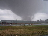
The strongest tornado was an F4 tornado on the Fujita scale
; it occurred in the vicinity of Madisonville, Kentucky
and Earlington, Kentucky
. It was also the strongest tornado recorded in the United States
in 2005.
of the National Weather Service
in Norman, Oklahoma
had issued a "high risk" for severe weather over an area from northern Mississippi
to central Indiana. Such a declaration is unusual (particularly for November) and means that there is a significant threat for severe thunderstorms with widespread tornadic activity. When the first tornado watch
es of the afternoon were issued, the SPC had declared a particularly dangerous situation
(PDS) for destructive tornadoes in several of the tornado watches, a highly unusual alert which notifies that frequent and dangerous tornadoes are possible, and by late that evening, no less than 50 tornadoes (including ten strong tornadoes and one violent tornado) were confirmed and several more unconfirmed tornadoes were reported (and later confirmed as microburst
s). Fortunately, the tornadoes were centered over more rural
areas and damage was scattered but severe over many communities. There were numerous injuries, but remarkably, only one person was killed. The low casualty toll is likely due to the fact the outbreak was well-predicted and primarily occurred in the afternoon when people are most aware of the situation.
This was the third major tornado outbreak of November 2005, the other two being in Evansville, Indiana
on November 6 (killing 25) and in much of Iowa
on November 12 (killing one). There was another major outbreak
in the same area on November 27 and 28.
Tornado outbreak
While there is no single agreed upon definition, generally at least 6-10 tornadoes produced by the same synoptic scale weather system is considered a tornado outbreak. The tornadoes usually occur within the same day, or continue into the early morning hours of the succeeding day, and within the...
on November 15, 2005 in the central United States
Central United States
The Central United States is sometimes conceived as between the Eastern United States and Western United States as part of a three-region model, roughly coincident with the Midwestern United States plus the western and central portions of the Southern United States; the term is also sometimes used...
. It occurred along a cold front
Cold front
A cold front is defined as the leading edge of a cooler mass of air, replacing a warmer mass of air.-Development of cold front:The cooler and denser air wedges under the less-dense warmer air, lifting it...
separating warm, humid air from the southeast from cold Arctic
Arctic
The Arctic is a region located at the northern-most part of the Earth. The Arctic consists of the Arctic Ocean and parts of Canada, Russia, Greenland, the United States, Norway, Sweden, Finland, and Iceland. The Arctic region consists of a vast, ice-covered ocean, surrounded by treeless permafrost...
air to the north and northwest. At least 50 confirmed tornado
Tornado
A tornado is a violent, dangerous, rotating column of air that is in contact with both the surface of the earth and a cumulonimbus cloud or, in rare cases, the base of a cumulus cloud. They are often referred to as a twister or a cyclone, although the word cyclone is used in meteorology in a wider...
es have been reported in the central United States in the states of Alabama
Alabama
Alabama is a state located in the southeastern region of the United States. It is bordered by Tennessee to the north, Georgia to the east, Florida and the Gulf of Mexico to the south, and Mississippi to the west. Alabama ranks 30th in total land area and ranks second in the size of its inland...
, Arkansas
Arkansas
Arkansas is a state located in the southern region of the United States. Its name is an Algonquian name of the Quapaw Indians. Arkansas shares borders with six states , and its eastern border is largely defined by the Mississippi River...
, Illinois
Illinois
Illinois is the fifth-most populous state of the United States of America, and is often noted for being a microcosm of the entire country. With Chicago in the northeast, small industrial cities and great agricultural productivity in central and northern Illinois, and natural resources like coal,...
, Indiana
Indiana
Indiana is a US state, admitted to the United States as the 19th on December 11, 1816. It is located in the Midwestern United States and Great Lakes Region. With 6,483,802 residents, the state is ranked 15th in population and 16th in population density. Indiana is ranked 38th in land area and is...
, Kentucky
Kentucky
The Commonwealth of Kentucky is a state located in the East Central United States of America. As classified by the United States Census Bureau, Kentucky is a Southern state, more specifically in the East South Central region. Kentucky is one of four U.S. states constituted as a commonwealth...
, Missouri
Missouri
Missouri is a US state located in the Midwestern United States, bordered by Iowa, Illinois, Kentucky, Tennessee, Arkansas, Oklahoma, Kansas and Nebraska. With a 2010 population of 5,988,927, Missouri is the 18th most populous state in the nation and the fifth most populous in the Midwest. It...
and Tennessee
Tennessee
Tennessee is a U.S. state located in the Southeastern United States. It has a population of 6,346,105, making it the nation's 17th-largest state by population, and covers , making it the 36th-largest by total land area...
over that afternoon and evening. Strong winds and large hail
Hail
Hail is a form of solid precipitation. It consists of balls or irregular lumps of ice, each of which is referred to as a hail stone. Hail stones on Earth consist mostly of water ice and measure between and in diameter, with the larger stones coming from severe thunderstorms...
caused additional damage throughout the region. The National Weather Service
National Weather Service
The National Weather Service , once known as the Weather Bureau, is one of the six scientific agencies that make up the National Oceanic and Atmospheric Administration of the United States government...
has reported at least 50 tornado touchdowns, although it is possible that a few have been multiple reports of the same tornado in different areas and several were not confirmed.
The strongest tornado was an F4 tornado on the Fujita scale
Fujita scale
The Fujita scale , or Fujita-Pearson scale, is a scale for rating tornado intensity, based primarily on the damage tornadoes inflict on human-built structures and vegetation...
; it occurred in the vicinity of Madisonville, Kentucky
Madisonville, Kentucky
Madisonville is a city in Hopkins County, Kentucky, United States of the Western Coal Field region, located along US 41 and The Pennyrile Parkway. The population was 19,307 at the 2000 census. It is the county seat of Hopkins County. The city was named in honor of U.S...
and Earlington, Kentucky
Earlington, Kentucky
Earlington is a city in Hopkins County, Kentucky, United States. As of the 2000 census, the city had a population of 1,649. It was founded by European Americans in 1870 around the area coal fields, and was named for John Baylis Earl, a lawyer who was central in developing the coal industry in the...
. It was also the strongest tornado recorded in the United States
United States
The United States of America is a federal constitutional republic comprising fifty states and a federal district...
in 2005.
Meteorological synopsis
The Storm Prediction CenterStorm Prediction Center
The Storm Prediction Center , located in Norman, Oklahoma, is tasked with forecasting the risk of severe thunderstorms and tornadoes in the contiguous United States. The agency issues convective outlooks, mesoscale discussions, and watches as a part of this process...
of the National Weather Service
National Weather Service
The National Weather Service , once known as the Weather Bureau, is one of the six scientific agencies that make up the National Oceanic and Atmospheric Administration of the United States government...
in Norman, Oklahoma
Norman, Oklahoma
Norman is a city in Cleveland County, Oklahoma, United States, and is located south of downtown Oklahoma City. It is part of the Oklahoma City metropolitan area. As of the 2010 census, Norman was to have 110,925 full-time residents, making it the third-largest city in Oklahoma and the...
had issued a "high risk" for severe weather over an area from northern Mississippi
Mississippi
Mississippi is a U.S. state located in the Southern United States. Jackson is the state capital and largest city. The name of the state derives from the Mississippi River, which flows along its western boundary, whose name comes from the Ojibwe word misi-ziibi...
to central Indiana. Such a declaration is unusual (particularly for November) and means that there is a significant threat for severe thunderstorms with widespread tornadic activity. When the first tornado watch
Tornado watch
A tornado watch is issued when conditions are right for a tornado to form. Since any thunderstorm capable of producing a tornado is defined as severe, a tornado watch is also automatically a severe thunderstorm watch...
es of the afternoon were issued, the SPC had declared a particularly dangerous situation
Particularly dangerous situation
A particularly dangerous situation is a type of enhanced wording first used by the National Weather Service's Storm Prediction Center in Norman, Oklahoma on certain severe weather watches...
(PDS) for destructive tornadoes in several of the tornado watches, a highly unusual alert which notifies that frequent and dangerous tornadoes are possible, and by late that evening, no less than 50 tornadoes (including ten strong tornadoes and one violent tornado) were confirmed and several more unconfirmed tornadoes were reported (and later confirmed as microburst
Microburst
A microburst is a very localized column of sinking air, producing damaging divergent and straight-line winds at the surface that are similar to, but distinguishable from, tornadoes, which generally have convergent damage. There are two types of microbursts: wet microbursts and dry microbursts...
s). Fortunately, the tornadoes were centered over more rural
Rural
Rural areas or the country or countryside are areas that are not urbanized, though when large areas are described, country towns and smaller cities will be included. They have a low population density, and typically much of the land is devoted to agriculture...
areas and damage was scattered but severe over many communities. There were numerous injuries, but remarkably, only one person was killed. The low casualty toll is likely due to the fact the outbreak was well-predicted and primarily occurred in the afternoon when people are most aware of the situation.
This was the third major tornado outbreak of November 2005, the other two being in Evansville, Indiana
Evansville Tornado of November 2005
- Evansville area tornado :On Sunday, November 6, 2005 at around 1:50 am CST , a tornado touched down 2 miles north-northwest of Smith Mills in Henderson County, Kentucky, near the Indiana/Kentucky border, and then crossed the Ohio River into Vanderburgh County, Indiana...
on November 6 (killing 25) and in much of Iowa
Iowa Tornado Outbreak of November 2005
The Iowa Tornado Outbreak of November 2005 was a large and exceptionally rare late autumn season tornado outbreak on the afternoon and evening of November 12, 2005 across the central United States but concentrated in central Iowa. At least one person was killed and there was extensive damage in...
on November 12 (killing one). There was another major outbreak
Late-November 2005 tornado outbreak
The Late-November 2005 tornado outbreak was a tornado outbreak that affected the Central United States on November 27 – November 28, 2005. The outbreak spawned 57 tornadoes over a two-day period; 49 on November 27, and 8 more on November 28...
in the same area on November 27 and 28.
Confirmed tornadoes
| List of confirmed tornadoes - Tuesday, November 15, 2005 | ||||||
|---|---|---|---|---|---|---|
Fujita scale The Fujita scale , or Fujita-Pearson scale, is a scale for rating tornado intensity, based primarily on the damage tornadoes inflict on human-built structures and vegetation... |
|
|
|
|
|
|
| Missouri Missouri Missouri is a US state located in the Midwestern United States, bordered by Iowa, Illinois, Kentucky, Tennessee, Arkansas, Oklahoma, Kansas and Nebraska. With a 2010 population of 5,988,927, Missouri is the 18th most populous state in the nation and the fifth most populous in the Midwest. It... |
||||||
| F0 | SW of East Prairie East Prairie, Missouri East Prairie is a city in Mississippi County, Missouri, United States. The population was 3,227 at the 2000 census. In 1881, the area was originally known as Bell's Grade and Hibbard and developed as a result of the railroad... |
New Madrid New Madrid County, Missouri New Madrid County is a county located in the Bootheel of southeast Missouri in the United States. As of the 2000 Census, the county's population was 19,760. A 2008 estimate, however, showed the population to be 17,589. The largest city and county seat is New Madrid... |
1837 | unknown | The first tornado of the outbreak was confirmed to be on the ground by the local sheriff Sheriff A sheriff is in principle a legal official with responsibility for a county. In practice, the specific combination of legal, political, and ceremonial duties of a sheriff varies greatly from country to country.... and lasted at least 10 minutes. No damage was reported. |
|
| F0 | NW of East Prairie East Prairie, Missouri East Prairie is a city in Mississippi County, Missouri, United States. The population was 3,227 at the 2000 census. In 1881, the area was originally known as Bell's Grade and Hibbard and developed as a result of the railroad... |
Mississippi Mississippi County, Missouri Mississippi County is a county located in the Bootheel of Southeast Missouri in the United States. As of the 2000 U.S. Census, the county's population was 13,427. A 2008 estimate, however, showed the population to be 13,504. The largest city and county seat is Charleston... |
1844 | unknown | Tornado sighted directly on Route 102 and reported by a local radio station Radio station Radio broadcasting is a one-way wireless transmission over radio waves intended to reach a wide audience. Stations can be linked in radio networks to broadcast a common radio format, either in broadcast syndication or simulcast or both... . No damage was reported. |
|
| F0 | SW of Lilbourn Lilbourn, Missouri Lilbourn is a city in New Madrid County, Missouri, United States. The population was 1,303 at the 2000 census.-Geography:Lilbourn is located at .According to the United States Census Bureau, the city has a total area of , all land.... |
New Madrid New Madrid County, Missouri New Madrid County is a county located in the Bootheel of southeast Missouri in the United States. As of the 2000 Census, the county's population was 19,760. A 2008 estimate, however, showed the population to be 17,589. The largest city and county seat is New Madrid... |
2044 | unknown | Damage was relatively minor; it was limited to a farm shed and several power poles. | |
| F1 | Lilbourn Lilbourn, Missouri Lilbourn is a city in New Madrid County, Missouri, United States. The population was 1,303 at the 2000 census.-Geography:Lilbourn is located at .According to the United States Census Bureau, the city has a total area of , all land.... |
New Madrid New Madrid County, Missouri New Madrid County is a county located in the Bootheel of southeast Missouri in the United States. As of the 2000 Census, the county's population was 19,760. A 2008 estimate, however, showed the population to be 17,589. The largest city and county seat is New Madrid... |
2055 | unknown | Several mobile homes were damaged, along with several farm buildings and outbuildings. Two people suffered minor injuries. | |
| Illinois Illinois Illinois is the fifth-most populous state of the United States of America, and is often noted for being a microcosm of the entire country. With Chicago in the northeast, small industrial cities and great agricultural productivity in central and northern Illinois, and natural resources like coal,... |
||||||
| F0 | Norris City Norris City, Illinois Norris City is a village in White County, Illinois. The population was 1,057 at the 2000 census.Norris City was incorporated in 1901.-Geography:Norris City is located at .... |
White White County, Illinois White County is a county located in the U.S. state of Illinois. According to the 2010 census, it has a population of 14,665, which is a decrease of 4.6% from 15,371 in 2000... |
1910 | unknown | ||
| F0 | W of Metropolis Metropolis, Illinois Metropolis is a city located along the Ohio River in Massac County, Illinois, in the United States. As of the 2000 census, the city population was 6,482... |
Massac | 1934 | unknown | Tornado partially a waterspout Waterspout A waterspout is an intense columnar vortex that occurs over a body of water and is connected to a cumuliform cloud. In the common form, it is a non-supercell tornado over water. While it is often weaker than most of its land counterparts, stronger versions spawned by mesocyclones do occur... on the Ohio River Ohio River The Ohio River is the largest tributary, by volume, of the Mississippi River. At the confluence, the Ohio is even bigger than the Mississippi and, thus, is hydrologically the main stream of the whole river system, including the Allegheny River further upstream... . |
|
| F1 | N of Omega | Marion | 2035 | 4.5 miles (7 km) |
Significant damage to several homes. Much of the path was through Stephan A. Forbes State Park. | |
| F1 | Newton Newton, Illinois Newton is the county seat of Jasper County, Illinois. The population was 3,069 at the 2000 Census and subsequently reported as 3,141 by a local newspaper in mid-2000. Newton is home to a large coal-fired power plant and Newton Lake State Fish and Wildlife Area.-Geography:Newton is located at... |
Jasper Jasper County, Illinois hjsdgcbi76dft... |
2115 | 10 miles (16 km) |
Minor structural damage to three houses, and several small buildings were destroyed, along with numerous trees and power lines. | |
| F0 | SW of Galatia Galatia, Illinois Galatia is a village in Saline County, Illinois, in the United States. As of the 2010 census, the village population was 933.-Geography:Galatia is located at .... |
Saline Saline County, Illinois Saline County is a county located in the U.S. state of Illinois. According to the 2010 census, it has a population of 24,913, which is a decrease of 6.8% from 26,733 in 2000. Its county seat is Harrisburg. Saline County is home to the smallest post office and the largest KFC in the United States.... |
2132 | unknown | No damage was reported. | |
| Tennessee Tennessee Tennessee is a U.S. state located in the Southeastern United States. It has a population of 6,346,105, making it the nation's 17th-largest state by population, and covers , making it the 36th-largest by total land area... |
||||||
| F1 | Friendship Friendship, Tennessee Friendship is a city in Crockett County, Tennessee, United States. The population was 668 at the 2010 census.-Geography:Friendship is located at .... area |
Crockett, Gibson | 1920 | 15 miles (24 km) |
Also affected Center and Dyer Dyer, Tennessee Dyer is a city in Gibson County, Tennessee, United States. The population was 2,406 at the 2000 census. Dyer was originally known as Peck's Switch, a name given by railroad workers in the early days of rail.-Tornado outbreak of April 2, 2006:... in addition to Friendship. Damage was moderate; only one house and several mobile homes suffered structural damage although numerous others suffered damage to shingles Roof shingle Roof shingles are a roof covering consisting of individual overlapping elements. These elements are typically flat rectangular shapes laid in rows from the bottom edge of the roof up, with each successive higher row overlapping the joints in the row below... along its 300 yard (270 m) path. |
|
| F1 | Greenfield Greenfield, Tennessee Greenfield is a city in Weakley County, Tennessee, United States. The population was 2,208 at the 2000 census.-Geography:Greenfield is located at .... area |
Crockett, Gibson | 1955 | unknown | At least seven houses were damaged, one of them significantly. No injuries were reported from this tornado. | |
| F2 | Paris Paris, Tennessee Paris is a city in Henry County, Tennessee, United States, west of Nashville, on a fork of the West Sandy River. In 1900, 2,018 people lived in Paris, Tennessee; in 1910, 3,881; and in 1940, 6,395. As of the 2000 census, the city had a total population of 9,763. It is the county seat of Henry... area |
Henry, Weakley | 2035 | 20 miles (32 km) |
Severe damage to many houses, at least 30 of which were completely destroyed, were reported along its path. Several manufacturing Manufacturing Manufacturing is the use of machines, tools and labor to produce goods for use or sale. The term may refer to a range of human activity, from handicraft to high tech, but is most commonly applied to industrial production, in which raw materials are transformed into finished goods on a large scale... facilities were also demolished. The Henry County emergency management center took a direct hit from one of the tornadoes and was forced to relocate. 13 people were injured. The tornado briefly produced a twin vortex. |
|
| F0 | S of Camden Camden, Tennessee Camden is a city in Benton County, Tennessee, United States. The population was 3,828 at the 2000 census. It is the county seat of Benton County.-Geography:Camden is positioned at... |
Benton | 2135 | unknown | No damage was reported. One of three related tornadoes. | |
| F1 | N of Camden Camden, Tennessee Camden is a city in Benton County, Tennessee, United States. The population was 3,828 at the 2000 census. It is the county seat of Benton County.-Geography:Camden is positioned at... |
Benton | 2136 | unknown | Minor damage, primarily blown over farm vehicles. One of three related tornadoes. | |
| F2 | N of Camden Camden, Tennessee Camden is a city in Benton County, Tennessee, United States. The population was 3,828 at the 2000 census. It is the county seat of Benton County.-Geography:Camden is positioned at... |
Benton | 2138 | unknown | Heavy damage to several homes, including total structural failure. One of three related tornadoes. | |
| F2 | SW of Erin Erin, Tennessee Erin is a city in Houston County, Tennessee, United States. The population was 1,490 at the 2000 census. It is the county seat of Houston County.-Geography:Erin is located at... |
Houston | 2204 | 1/2 mile (800 m) |
||
| F1 | Erin Erin, Tennessee Erin is a city in Houston County, Tennessee, United States. The population was 1,490 at the 2000 census. It is the county seat of Houston County.-Geography:Erin is located at... |
Houston | 2210 | 1/10 mile (200 m) |
No damage to buildings, however trees were snapped. | |
| F0 | SW of Erin Erin, Tennessee Erin is a city in Houston County, Tennessee, United States. The population was 1,490 at the 2000 census. It is the county seat of Houston County.-Geography:Erin is located at... |
Houston | 2211 | 1/10 mile (200 m) |
||
| F1 | S of Clarksville Clarksville, Tennessee Clarksville is a city in and the county seat of Montgomery County, Tennessee, United States, and the fifth largest city in the state. The population was 132,929 in 2010 United States Census... |
Montgomery Montgomery County, Tennessee Montgomery County is a county located in the U.S. state of Tennessee. The county seat is Clarksville. The population was 172,331 at the 2010 census. It is one of the four counties included in the Clarksville, TN–KY Metropolitan Statistical Area.... |
2235 | 3 miles (5 km) |
One of two separate tornadoes near the above Clarksville tornado along the Highway 13 corridor. This one heavily damaged a mobile home. | |
| F0 | S of Clarksville Clarksville, Tennessee Clarksville is a city in and the county seat of Montgomery County, Tennessee, United States, and the fifth largest city in the state. The population was 132,929 in 2010 United States Census... |
Montgomery Montgomery County, Tennessee Montgomery County is a county located in the U.S. state of Tennessee. The county seat is Clarksville. The population was 172,331 at the 2010 census. It is one of the four counties included in the Clarksville, TN–KY Metropolitan Statistical Area.... |
2236 | 1/5 mile (300 m) |
The other of two separate tornadoes near the above Clarksville tornado along the Highway 13 corridor. | |
| F0 | Cunningham | Montgomery Montgomery County, Tennessee Montgomery County is a county located in the U.S. state of Tennessee. The county seat is Clarksville. The population was 172,331 at the 2010 census. It is one of the four counties included in the Clarksville, TN–KY Metropolitan Statistical Area.... |
2237 | 1/5 mile (300 m) |
||
| F2 | S of Clarksville Clarksville, Tennessee Clarksville is a city in and the county seat of Montgomery County, Tennessee, United States, and the fifth largest city in the state. The population was 132,929 in 2010 United States Census... |
Houston, Montgomery Montgomery County, Tennessee Montgomery County is a county located in the U.S. state of Tennessee. The county seat is Clarksville. The population was 172,331 at the 2010 census. It is one of the four counties included in the Clarksville, TN–KY Metropolitan Statistical Area.... |
2244 | 20 miles (32 km) |
Many houses were hit, a tractor trailer was overturned and severe damage to many buildings, including several being completely destroyed, was reported along a section of Highway 13 and several local streets in the area about 6 miles (10 km) south of Clarksville. Several people were injured and reported missing initially but they were all accounted for. | |
| F0 | NE of Holladay | Humphreys Humphreys County, Tennessee Humphreys County is a county located in the U.S. state of Tennessee. As of 2000, the population was 17,929. The 2005 Census Estimate placed the population at 18,212. Its county seat is Waverly.-Geography:According to the U.S... |
2250 | 1/5 mile (300 m) |
||
| F1 | New Johnsonville New Johnsonville, Tennessee New Johnsonville is a city in Humphreys County, Tennessee, United States. The population was 1,905 at the 2000 census.-Geography:New Johnsonville is located at .... |
Humphreys Humphreys County, Tennessee Humphreys County is a county located in the U.S. state of Tennessee. As of 2000, the population was 17,929. The 2005 Census Estimate placed the population at 18,212. Its county seat is Waverly.-Geography:According to the U.S... |
2255 | unknown | Two houses sustained some degree of roof damage. | |
| F2 | N of Dickson Dickson, Tennessee Dickson is a city in Dickson County, Tennessee, United States. It is part of the Nashville Metropolitan Statistical Area. The population was 12,244 at the 2000 census.-Demographics:... |
Dickson | 2333 | 1 mile (1.6 km) |
Several homes and barns damaged in the area, including roofs being removed from at least one home. Several minor injuries have been reported and a gas leak erupted from a damaged building. | |
| F0 | N of Charlotte Charlotte, Tennessee Charlotte is a town in Dickson County, Tennessee, United States. The population was 1,153 at the 2000 census. It is the county seat of Dickson County.-Geography:... |
Dickson | 2340 | 1/5 mile (300 m) |
||
| F2 | Collinwood Collinwood, Tennessee Collinwood is a city in Wayne County, Tennessee, United States. The population was 982 at the 2010 census.-Geography:Collinwood is located at .... |
Wayne Wayne County, Tennessee As of the census of 2010, there were 17,021 people, 5,822 households, and 4,321 families residing in the county. The population density was 23 people per square mile . There were 6,701 housing units at an average density of 9 per square mile... |
0002 | 6 miles (10 km) |
Numerous homes were damaged, along with a funeral home Funeral home A funeral home, funeral parlor or mortuary, is a business that provides burial and funeral services for the deceased and their families. These services may include aprepared wake and funeral, and the provision of a chapel for the funeral.... , several barns and a church along Highway 13. One minor injury was reported. |
|
| F0 | SW of Coopertown Coopertown, Tennessee Coopertown is a town in Robertson County, Tennessee, United States. The population of the self-described "bedroom community" was 3,027 at the 2000 census.-History:... |
Robertson | 0006 | 1/10 mile (200 m) |
Damaged noticed from Interstate 24 Interstate 24 Interstate 24 is an Interstate Highway in the Midwestern and Southeastern United States. It runs diagonally from Interstate 57 to Chattanooga, Tennessee, at Interstate 75.... at the Highway 49 interchange. |
|
| F0 | NW part of Nashville Nashville, Tennessee Nashville is the capital of the U.S. state of Tennessee and the county seat of Davidson County. It is located on the Cumberland River in Davidson County, in the north-central part of the state. The city is a center for the health care, publishing, banking and transportation industries, and is home... |
Davidson Davidson County, Tennessee Davidson County is a county located in the U.S. state of Tennessee. As of 2010, the population was 626,681. Its county seat is Nashville.In 1963, the City of Nashville and the Davidson County government merged, so the county government is now known as the "Metropolitan Government of Nashville and... |
0015 | unknown | Power lines were snapped along a short section of Whites Creek Pike. Damage report was from Nashville Electric Service Nashville Electric Service Nashville Electric Service is among the twelve largest public electric utilities in the nation, currently employing a little over 1000 employees, and distributing energy to more than 350,000 customers in Middle Tennessee... . |
|
| F0 | N of Columbia Columbia, Tennessee Columbia is a city in Maury County, Tennessee, United States. The 2008 population was 34,402 according to U.S. Census Bureau estimates. It is the county seat of Maury County.... |
Maury | 0025 | unknown | Reported by a trained spotter. | |
| F0 | SW of Franklin Franklin, Tennessee Franklin is a city within and the county seat of Williamson County, Tennessee, United States. The population was 62,487 as of the 2010 census Franklin is located approximately south of downtown Nashville.-History:... |
Williamson Williamson County, Tennessee Williamson County is a county in the U.S. state of Tennessee. As of 2010 US Census, the population was 183,182. The County's seat is Franklin, and it is part of the Nashville-Davidson–Murfreesboro–Franklin Metropolitan Statistical Area. The county is named after Hugh Williamson, a... |
0032 | unknown | Reported by an NWS co-op spotter. | |
| F0 | E of Hendersonville Hendersonville, Tennessee Hendersonville is a city in Sumner County, Tennessee, United States, on Old Hickory Lake. The population was 51,372 at the 2010 census. Hendersonville is part of the Nashville Metropolitan Statistical Area and is located 18 miles northeast of downtown Nashville. The city was settled around 1784 by... |
Sumner Sumner County, Tennessee Sumner County is a county located in the U.S. state of Tennessee. As of 2000, the population was 130,449. Its county seat is Gallatin, but its largest town is Hendersonville... |
0042 | unknown | ||
| Kentucky Kentucky The Commonwealth of Kentucky is a state located in the East Central United States of America. As classified by the United States Census Bureau, Kentucky is a Southern state, more specifically in the East South Central region. Kentucky is one of four U.S. states constituted as a commonwealth... |
||||||
| F0 | Rossington | McCracken McCracken County, Kentucky McCracken County is a county located in the Jackson Purchase, the extreme western end of the U.S. state of Kentucky. As of 2000, the population was 65,514. The county seat, largest city, and only incorporated community is Paducah.... |
1930 | unknown | ||
| F3 | Benton Benton, Kentucky Benton is a city in Marshall County, Kentucky, United States. The population was 4,197 at the 2000 census. It is the county seat of Marshall County.... area |
Graves Graves County, Kentucky Graves County is a county located in the U.S. Commonwealth of Kentucky. It was formed in 1824. As of 2000, the population was 37,028. Its county seat is Mayfield. The county is named for Major Benjamin Franklin Graves, soldier in the War of 1812... , Calloway Calloway County, Kentucky Calloway County is a county located in the U.S. state of Kentucky. It was formed in 1823. As of 2010, the population was 37,191. Its county seat is Murray, Kentucky. The county is named for Colonel Richard Callaway, one of the founders of Boonesborough... , Marshall Marshall County, Kentucky Marshall County is a county located in the U.S. state of Kentucky. As of 2000, the population was 30,125. The 2007 Census Bureau population estimate was 31,258. Its county seat is Benton. It was a dry county until 2004, when residents of Calvert City voted to allow sales of liquor by the drink in... , Lyon Lyon County, Kentucky Lyon County is a county located in the U.S. state of Kentucky. As of 2000, the population was 8,080. Its county seat is Eddyville. Created from Caldwell County, Kentucky in 1854, the county was named for former Congressman Chittenden Lyon.... |
1945 | 44.1 miles (70 km) |
1 death - Local authorities confirmed that there have been at least two buildings damaged in the town of Benton. In addition, a mobile home Mobile home Mobile homes or static caravans are prefabricated homes built in factories, rather than on site, and then taken to the place where they will be occupied... park on Kentucky Lake Kentucky Lake Kentucky Lake is a major navigable reservoir along the Tennessee River in Kentucky and Tennessee. Created in 1944 by the Tennessee Valley Authority's impounding of the Tennessee River by Kentucky Dam, the lake is the largest artificial lake by surface area in the United States east of the... was severely damaged as well and many were destroyed, killing one person in the park. 10 others were injured. The tornado remained on the ground for nearly an hour, damaging 120 structures and destroying at least 19. |
|
| F0 | S of Princeton Princeton, Kentucky Princeton is a city in Caldwell County, Kentucky, United States. The population was 6,329 at the 2010 census. It is the county seat of Caldwell County.-History:... |
Caldwell Caldwell County, Kentucky As of the census of 2010, there were 12,984 people, with 6,292 households in the county.-Communities:*Bakers*Baldwin Ford*Black Hawk*The Bluff*Cedar Bluff*Claxton*Cobb*Cresswell*Crider*Crowtown*Enon*Farmersville*Flat Rock*Friendship*Fryer... |
2101 | unknown | ||
| F4 | Madisonville Madisonville, Kentucky Madisonville is a city in Hopkins County, Kentucky, United States of the Western Coal Field region, located along US 41 and The Pennyrile Parkway. The population was 19,307 at the 2000 census. It is the county seat of Hopkins County. The city was named in honor of U.S... area |
Hopkins Hopkins County, Kentucky Hopkins County is a county located in the U.S. state of Kentucky. It was formed in 1807. As of 2000, the population was 46,519. Its county seat is Madisonville. The county is named for General Samuel Hopkins, an officer in both the Revolutionary War and War of 1812, and later a Kentucky legislator... |
2135 | 15 miles (24 km) |
The strongest tornado of the outbreak. At least 150 buildings were destroyed and over 360 others were damaged to varying degrees. 37 people were injured, including two critically. Multiple vortexes in the tornado were reported near Earlington Earlington, Kentucky Earlington is a city in Hopkins County, Kentucky, United States. As of the 2000 census, the city had a population of 1,649. It was founded by European Americans in 1870 around the area coal fields, and was named for John Baylis Earl, a lawyer who was central in developing the coal industry in the... along its path which was up to 1/2 mile (800 m) wide. It was the strongest tornado recorded in 2005 in the United States. |
|
| F1 | NE of Calhoun Calhoun, Kentucky Calhoun is a city in McLean County, Kentucky, United States. The population was 836 at the 2000 census. It is the county seat of McLean County. It is included in the Owensboro, Kentucky Metropolitan Statistical Area... |
McLean McLean County, Kentucky McLean County is a county located in the U.S. state of Kentucky; its population was 9,938 in the 2000 Census. McLean County's county seat is at Calhoun.... |
2204 | unknown | Reported over the intersection of Highway 1046 and Highway 136. No damage was reported. | |
| F0 | Utica Utica, Kentucky Utica, Kentucky is a small rural community approximately ten miles to the south of Owensboro, Kentucky, near the border of Daviess and Mclean counties.It has a post office, a fire station, a baptist and methodist church, a gas station, and a store called JR's Market. A new Farm market called... |
Daviess Daviess County, Kentucky As of the census of 2000, there were 91,545 people, 36,033 households, and 24,826 families residing in the county. The population density was . There were 38,432 housing units at an average density of... |
2215 | unknown | No damage was reported, but it was confirmed by photographs and Daviess County Emergency Management. | |
| F1 | Adairville Adairville, Kentucky Adairville is a city in Logan County, Kentucky, United States. The population was 920 at the 2000 census.-Geography:Adairville is located at .... area |
Logan Logan County, Kentucky Logan County is a county located in the southwest area of the U.S. state of Kentucky. As of 2000, the population was 26,573. Its county seat is Russellville... , Simpson Simpson County, Kentucky Simpson County is a county located in the U.S. state of Kentucky. As of 2000, the population was 16,405. Its county seat is Franklin. The county is named for Captain John Simpson, a Kentucky militia officer who fought in Battle of Fallen Timbers in the Northwest Indian War, and was killed in the... |
2315 | 10 miles (16 km) |
A mobile home was thrown onto Highway 100 Kentucky State Highway 100 Kentucky Route 100 originates at a junction with U.S. Highway 68X in Russellville in Logan County. The route continues through Simpson County, Allen County and Monroe County to terminate at a junction with KY 90 near Waterview in Cumberland County.... and a barn was destroyed. |
|
| F2 | Stowers | Simpson Simpson County, Kentucky Simpson County is a county located in the U.S. state of Kentucky. As of 2000, the population was 16,405. Its county seat is Franklin. The county is named for Captain John Simpson, a Kentucky militia officer who fought in Battle of Fallen Timbers in the Northwest Indian War, and was killed in the... |
2345 | 3 miles (5 km) |
Significant damage to trees and power lines were reported in the area. Initially thought to have been straight-line winds but later confirmed as a tornado. | |
| F1 | Woodburn Woodburn, Kentucky Woodburn is a city in Warren County, Kentucky, United States. The population was 323 at the 2000 census and 355 at the 2010 census. It is included in the Bowling Green, Kentucky Metropolitan Statistical Area.-Geography:... area |
Warren Warren County, Kentucky Warren County is a county located in the U.S. state of Kentucky, specifically the Pennyroyal Plateau and Western Coal Fields regions. It is included in the Bowling Green, Kentucky, Metropolitan Statistical Area. The population was 113,792 in the 2010 Census. The county seat is Bowling Green... |
2350 | 2.5 miles (4 km) |
Damage primarily to farms, including several buildings destroyed. Initially thought to have been straight-line winds. | |
| Arkansas Arkansas Arkansas is a state located in the southern region of the United States. Its name is an Algonquian name of the Quapaw Indians. Arkansas shares borders with six states , and its eastern border is largely defined by the Mississippi River... |
||||||
| F0 | SW of Pine Bluff Pine Bluff, Arkansas Pine Bluff is the largest city and county seat of Jefferson County, Arkansas, United States. It is also the principal city of the Pine Bluff Metropolitan Statistical Area and part of the Little Rock-North Little Rock-Pine Bluff, Arkansas Combined Statistical Area... |
Jefferson Jefferson County, Arkansas Jefferson County is a county located in the U.S. state of Arkansas. Its population was 77,435 at the 2010 United States Census. It is included in the Pine Bluff Metropolitan Statistical Area. Jefferson County's county seat and largest city is Pine Bluff... |
2032 | 7/10 mile (1.1 km) |
No structural damage was reported, but several trees were down in the area and one chimney Chimney A chimney is a structure for venting hot flue gases or smoke from a boiler, stove, furnace or fireplace to the outside atmosphere. Chimneys are typically vertical, or as near as possible to vertical, to ensure that the gases flow smoothly, drawing air into the combustion in what is known as the... was damaged. |
|
| F1 | DeLuce area | Arkansas Arkansas County, Arkansas Arkansas County is a county located in the U.S. state of Arkansas. As of the 2010 census, the population was 19,019. The county has two county seats, De Witt and Stuttgart... |
unknown | 16.5 miles (27 km) |
One outbuilding and one barn was destroyed, plus major damage to several others of each. Minor damage to several homes, plus many trees were uprooted or snapped. | |
| F1 | S of DeWitt | Arkansas Arkansas County, Arkansas Arkansas County is a county located in the U.S. state of Arkansas. As of the 2010 census, the population was 19,019. The county has two county seats, De Witt and Stuttgart... |
unknown | 3.5 miles (5.5 km) |
Damage was reported to tin Tin Tin is a chemical element with the symbol Sn and atomic number 50. It is a main group metal in group 14 of the periodic table. Tin shows chemical similarity to both neighboring group 14 elements, germanium and lead and has two possible oxidation states, +2 and the slightly more stable +4... barn roofs. Numerous trees fell. |
|
| Indiana Indiana Indiana is a US state, admitted to the United States as the 19th on December 11, 1816. It is located in the Midwestern United States and Great Lakes Region. With 6,483,802 residents, the state is ranked 15th in population and 16th in population density. Indiana is ranked 38th in land area and is... |
||||||
| F3 | Washington Washington, Indiana Washington is a city in Daviess County, Indiana, United States. The population was 11,509 at the 2010 census. The city is the county seat of Daviess County.-History:... area |
Daviess Daviess County, Indiana Daviess County is a county located in the U.S. state of Indiana. As of 2010, the population was 31,648. The county seat is Washington. Daviess County switched to the Central Time Zone on April 2, 2006. It has returned to the Eastern Time Zone as of November 4, 2007.- History :Daviess County was... , Martin Martin County, Indiana As of the census of 2000, there were 10,369 people, 4,183 households, and 2,877 families residing in the county. The population density was 31 people per square mile . There were 4,729 housing units at an average density of 14 per square mile... |
2040 | 12 miles (20 km) |
Destroyed at least 64 homes and damaged at least 70 more along the US 150 corridor in Washington, Cannelburg Cannelburg, Indiana Cannelburg is a town in Barr Township, Daviess County, Indiana, United States. The population was 135 at the 2010 census. The settlement was first known as Clark's Station, after an early settler, renamed in 1872 for the cannel coal mined in the area.... and Loogootee Loogootee, Indiana -Demographics:As of the census of 2000, there were 2,741 people, 1,226 households, and 712 families residing in the city. The population density was 1,750.5 people per square mile . There were 1,337 housing units at an average density of 853.8 per square mile... . Up to 200 employees were trapped at K&K Industries in Montgomery Montgomery, Indiana Montgomery is a town in Barr Township, Daviess County, Indiana, United States. The population was 343 at the 2010 census.-Geography:Montgomery is located at .... , but they were all accounted for. |
|
| F3 | Geneva (Shelby County) area | Bartholomew Bartholomew County, Indiana Bartholomew County is a county located in the U.S. state of Indiana, and determined by the U.S. Census Bureau to include the mean center of U.S. population in 1900. As of 2010, the population was 76,794... , Shelby Shelby County, Indiana As of the census of 2000, there were 43,445 people, 16,561 households, and 12,056 families residing in the county. The population density was 105 people per square mile . There were 17,633 housing units at an average density of 43 per square mile... , Decatur Decatur County, Indiana As of the census of 2000, there were 24,555 people, 9,389 households, and 6,882 families residing in the county. The population density was 66 people per square mile . There were 9,992 housing units at an average density of 27 per square mile... |
2230 | 14 miles (23 km) |
First touched down just outside of Hope Hope, Indiana Hope is a town in Haw Creek Township, Bartholomew County, Indiana, United States. The population was 2,102 at the 2010 census. It is part of the Columbus, Indiana, metropolitan statistical area.-Geography:Hope is located at .... then basically followed Highway 9. Damage was extensive along its path; a hog farm was destroyed and a farmhouse was pushed off its foundation near Geneva. The tornado was about 300 yards (270 m) wide. One person was injured by this tornado. |
|
| F1 | SW of Van Buren Van Buren, Indiana Van Buren is a town in Van Buren Township, Grant County, Indiana, United States. The population was 935 at the 2000 census.-Geography:Van Buren is located at .... |
Grant Grant County, Indiana Grant County is a county located in the U.S. state of Indiana. As of the 2010 census, the population was 70,061. The county seat is Marion. Important paleontological discoveries dating from the Pliocene epoch have been made at Pipe Creek Sinkhole in Grant County.-Geography:According to the 2010... |
unknown | 3 miles (5 km) |
Minor damage to a roof on one home and damage to several grain elevator Grain elevator A grain elevator is a tower containing a bucket elevator, which scoops up, elevates, and then uses gravity to deposit grain in a silo or other storage facility... s. Some trees and power lines were also snapped, and a truck was blown off of Interstate 69 Interstate 69 Interstate 69 is an Interstate Highway in the United States. It exists in two parts: a completed highway from Indianapolis, Indiana, northeast to the Canadian border in Port Huron, Michigan, and a mostly proposed extension southwest to the Mexican border in Texas... . |
|
| F1 | N of Bedford Bedford, Indiana As of the census of 2000, there were 13,768 people, 6,054 households, and 3,644 families residing in the city. The population density was 1,157.1 people per square mile . There were 6,618 housing units at an average density of 556.2 per square mile... |
Lawrence Lawrence County, Indiana As of the census of 2000, there were 45,922 people, 18,535 households, and 13,141 families residing in the county. The population density was 102 people per square mile . There were 20,560 housing units at an average density of 46 per square mile... |
unknown | unknown | Brief Touchdown. | |
| Alabama Alabama Alabama is a state located in the southeastern region of the United States. It is bordered by Tennessee to the north, Georgia to the east, Florida and the Gulf of Mexico to the south, and Mississippi to the west. Alabama ranks 30th in total land area and ranks second in the size of its inland... |
||||||
| F0 | Vernon Vernon, Alabama Vernon is a city in Lamar County, Alabama, United States. At the 2000 census the population was 2,143. The city is the county seat of Lamar County.- Geography :Vernon is located at .According to the U.S... |
Lamar Lamar County, Alabama Lamar County is a county of the U.S. state of Alabama. Its name is in honor of Lucius Quintus Cincinnatus Lamar, member of the United States Senate from Mississippi. As of 2010 the population was 14,564... |
0030 | unknown | Brief tornado touchdown. Minor damage to several buildings. | |
| F0 | Crane Hill | Cullman Cullman County, Alabama Cullman County is a county of the U.S. state of Alabama. Its name is in honor of Colonel John G. Cullmann. As of 2010, the population was 80,406. Its county seat is the town of the same name, Cullman, Alabama. It is a "moist" county in terms of availablity of alcoholic beverages, which means... |
0230 | unknown | Damage was reported to several houses and businesses, along with many trees and power lines. | |
| Sources: NOAA storm data, Paducah office, Memphis office, Little Rock office, Lincoln office, Louisville office, St. Louis office, Nashville office, Northern Indiana office, WCDQ Radio news, WSMB | ||||||
External links
- Storm Reports for Nov. 15 (NWS Storm Prediction Center)
- Nashville weather site with photos of damage in Middle Tennessee
- National Weather Service-Paducah, KY Report
- National Weather Service-Central Illinois Report
- Marion County, IL Tornado (NWS St. Louis)
- National Weather Service-Memphis, TN Report
- Montgomery/Dickson County Storm Damage (NWS Nashville, TN)
- Wayne County Storm Damage {NWS Nashville, TN)
- Benton/Humphreys/Houston County Storm Damage {NWS Nashville, TN)
- National Weather Service-Northern Indiana Report