
Iowa Tornado Outbreak of November 2005
Encyclopedia
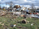
The Iowa Tornado Outbreak of November 2005 was a large and exceptionally rare late autumn season tornado outbreak
on the afternoon and evening of November 12, 2005 across the central United States
but concentrated in central Iowa
. At least one person was killed and there was extensive damage in several communities. Another tornado
and severe thunderstorm outbreak generated from the same storm system that produced the Iowa outbreak produced damaging tornadoes with injuries concentrated across southwest Missouri
.
There are preliminary reports of as many as twenty tornadoes in Iowa, and 15 were later confirmed including 13 in Iowa alone. It is the largest ever tornado outbreak in Iowa in November; and among the largest outbreaks that far north and west in the United States that late in the year. Only 23 confirmed tornadoes have been recorded in Iowa in November from 1950-2004. There were also many reports of very large hail and strong straight-line winds, starting in southeast South Dakota
.
A tornado caused some damage including deroofing a business in Hospers
in Sioux County
.
In addition, the tornado sirens sounded just before an Iowa State University
Cyclones football game incurring an evacuation of the stadium. The tornado was visible from the stadium. The Iowa State Cyclones, named partly for a violent tornado in the early 20th century returned to the field and were shockingly victorious. Another tornado struck the actual ISU campus a couple months prior on September 8 with extensive minor damage.
Tornado outbreak
While there is no single agreed upon definition, generally at least 6-10 tornadoes produced by the same synoptic scale weather system is considered a tornado outbreak. The tornadoes usually occur within the same day, or continue into the early morning hours of the succeeding day, and within the...
on the afternoon and evening of November 12, 2005 across the central United States
United States
The United States of America is a federal constitutional republic comprising fifty states and a federal district...
but concentrated in central Iowa
Iowa
Iowa is a state located in the Midwestern United States, an area often referred to as the "American Heartland". It derives its name from the Ioway people, one of the many American Indian tribes that occupied the state at the time of European exploration. Iowa was a part of the French colony of New...
. At least one person was killed and there was extensive damage in several communities. Another tornado
Tornado
A tornado is a violent, dangerous, rotating column of air that is in contact with both the surface of the earth and a cumulonimbus cloud or, in rare cases, the base of a cumulus cloud. They are often referred to as a twister or a cyclone, although the word cyclone is used in meteorology in a wider...
and severe thunderstorm outbreak generated from the same storm system that produced the Iowa outbreak produced damaging tornadoes with injuries concentrated across southwest Missouri
Missouri
Missouri is a US state located in the Midwestern United States, bordered by Iowa, Illinois, Kentucky, Tennessee, Arkansas, Oklahoma, Kansas and Nebraska. With a 2010 population of 5,988,927, Missouri is the 18th most populous state in the nation and the fifth most populous in the Midwest. It...
.
There are preliminary reports of as many as twenty tornadoes in Iowa, and 15 were later confirmed including 13 in Iowa alone. It is the largest ever tornado outbreak in Iowa in November; and among the largest outbreaks that far north and west in the United States that late in the year. Only 23 confirmed tornadoes have been recorded in Iowa in November from 1950-2004. There were also many reports of very large hail and strong straight-line winds, starting in southeast South Dakota
South Dakota
South Dakota is a state located in the Midwestern region of the United States. It is named after the Lakota and Dakota Sioux American Indian tribes. Once a part of Dakota Territory, South Dakota became a state on November 2, 1889. The state has an area of and an estimated population of just over...
.
A tornado caused some damage including deroofing a business in Hospers
Hospers, Iowa
Hospers is a city in Sioux County, Iowa, United States, along the Floyd River. The population was 672 at the 2000 census.-Geography:Hospers is located at ....
in Sioux County
Sioux County, Iowa
-2010 census:The 2010 census recorded a population of 33,704 in the county, with a population density of . There were 12,279 housing units, of which 11,584 were occupied.-2000 census:...
.
In addition, the tornado sirens sounded just before an Iowa State University
Iowa State University
Iowa State University of Science and Technology, more commonly known as Iowa State University , is a public land-grant and space-grant research university located in Ames, Iowa, United States. Iowa State has produced astronauts, scientists, and Nobel and Pulitzer Prize winners, along with a host of...
Cyclones football game incurring an evacuation of the stadium. The tornado was visible from the stadium. The Iowa State Cyclones, named partly for a violent tornado in the early 20th century returned to the field and were shockingly victorious. Another tornado struck the actual ISU campus a couple months prior on September 8 with extensive minor damage.
Confirmed tornadoes
| F# Fujita scale The Fujita scale , or Fujita-Pearson scale, is a scale for rating tornado intensity, based primarily on the damage tornadoes inflict on human-built structures and vegetation... |
Location | County | Time (UTC) | Path length | Damage | |
|---|---|---|---|---|---|---|
| Iowa Iowa Iowa is a state located in the Midwestern United States, an area often referred to as the "American Heartland". It derives its name from the Ioway people, one of the many American Indian tribes that occupied the state at the time of European exploration. Iowa was a part of the French colony of New... |
||||||
| F1 | N of Bayard Bayard, Iowa As of the census of 2000, there were 536 people, 221 households, and 135 families residing in the city. The population density was 1,124.9 people per square mile . There were 244 housing units at an average density of 512.1 per square mile . The racial makeup of the city was 99.07% White, 0.19%... |
Greene Greene County, Iowa -2010 census:The 2010 census recorded a population of 9,336 in the county, with a population density of . There were 4,546 housing units, of which 3,996 were occupied.-2000 census:... |
2150 | 1 miles (1.6 km) |
||
| F3 | Stratford Stratford, Iowa Stratford is a city in Hamilton and Webster counties in the U.S. state of Iowa. As of the 2000 census, the city population was 746.-Geography:Stratford's longitude and latitude coordinatesin decimal form are 42.270919, -93.926862... area |
Boone Boone County, Iowa -2010 census:The 2010 census recorded a population of 26,306 in the county, with a population density of . There were 11,756 housing units, of which 10,728 were occupied.-2000 census:... , Webster Webster County, Iowa -2010 census:The 2010 census recorded a population of 38,013 in the county, with a population density of . There were 17,035 housing units, of which 15,580 were occupied.-2000 census:... , Hamilton Hamilton County, Iowa -2010 census:The 2010 census recorded a population of 15,673 in the county, with a population density of . There were 7,219 housing units, of which 6,540 were occupied.-2000 census:... |
2227 | 17.6 miles (28.2 km) |
1 death - There was extensive tornado damage across the southern half of the town. At least two dozen homes completely destroyed and many others damaged along its 150 yard (165 m) wide path. One person was killed and another was injured. A gas leak Gas leak In common usage, a gas leak refers to a leak of natural gas, from a pipe or other containment, into a living area or any other area where the gas should not be... forced the evacuation of most of the town impeding rescue efforts. |
|
| F2 | Woodward Woodward, Iowa As of the census of 2000, there were 1,200 people, 490 households, and 309 families residing in the city. The population density was 1,319.1 people per square mile . There were 528 housing units at an average density of 580.4 per square mile... area |
Dallas Dallas County, Iowa -2010 census:The 2010 census recorded a population of 66,135 in the county, with a population density of . There were 27,260 housing units, of which 25,240 were occupied.-2000 census:... |
2228 | 12 miles (19.2 km) |
Dozens of homes damaged or destroyed, including several homes shifted off their foundations. One farm was also destroyed. | |
| F1 | E of Hospers Hospers, Iowa Hospers is a city in Sioux County, Iowa, United States, along the Floyd River. The population was 672 at the 2000 census.-Geography:Hospers is located at .... |
Sioux Sioux County, Iowa -2010 census:The 2010 census recorded a population of 33,704 in the county, with a population density of . There were 12,279 housing units, of which 11,584 were occupied.-2000 census:... |
2230 | 1 miles (1.6 km) |
||
| F2 | NW of Madrid Madrid, Iowa Madrid is a city in Douglas Township, Boone County, Iowa, United States. The population was 2,264 at the 2000 census. It is part of the 'Boone, Iowa Micropolitan Statistical Area', which is a part of the larger 'Ames-Boone, Iowa Combined Statistical Area'.... |
Boone Boone County, Iowa -2010 census:The 2010 census recorded a population of 26,306 in the county, with a population density of . There were 11,756 housing units, of which 10,728 were occupied.-2000 census:... |
2241 | 1 miles (1.6 km) |
||
| F1 | W of Luther Luther, Iowa Luther is a city in Worth Township, Boone County, Iowa, United States. The population was 158 at the 2000 census. It is part of the 'Boone, Iowa Micropolitan Statistical Area', which is a part of the larger 'Ames-Boone, Iowa Combined Statistical Area'.... |
Boone Boone County, Iowa -2010 census:The 2010 census recorded a population of 26,306 in the county, with a population density of . There were 11,756 housing units, of which 10,728 were occupied.-2000 census:... |
2248 | 6 miles (9.6 km) |
Heavy damage to one farm site and moderate damage to one home. | |
| F0 | Ames Ames, Iowa Ames is a city located in the central part of the U.S. state of Iowa in Story County, and approximately north of Des Moines. The U.S. Census Bureau designates that Ames, Iowa metropolitan statistical area as encompassing all of Story County, and which, when combined with the Boone, Iowa... area |
Story Story County, Iowa -2010 census:The 2010 census recorded a population of 89,542 in the county, with a population density of . There were 36,789 housing units, of which 34,736 were occupied.-2000 census:... |
2256 | 0.2 miles (0.32 km) |
||
| F2 | N of Ames Ames, Iowa Ames is a city located in the central part of the U.S. state of Iowa in Story County, and approximately north of Des Moines. The U.S. Census Bureau designates that Ames, Iowa metropolitan statistical area as encompassing all of Story County, and which, when combined with the Boone, Iowa... |
Boone Boone County, Iowa -2010 census:The 2010 census recorded a population of 26,306 in the county, with a population density of . There were 11,756 housing units, of which 10,728 were occupied.-2000 census:... , Story Story County, Iowa -2010 census:The 2010 census recorded a population of 89,542 in the county, with a population density of . There were 36,789 housing units, of which 34,736 were occupied.-2000 census:... |
2258 | 12 miles (19.2 km) |
Heavy damage to several homes along its path. Tornado was visible from Iowa State University Iowa State University Iowa State University of Science and Technology, more commonly known as Iowa State University , is a public land-grant and space-grant research university located in Ames, Iowa, United States. Iowa State has produced astronauts, scientists, and Nobel and Pulitzer Prize winners, along with a host of... and forced the evacuation of the stadium during a football American football American football is a sport played between two teams of eleven with the objective of scoring points by advancing the ball into the opposing team's end zone. Known in the United States simply as football, it may also be referred to informally as gridiron football. The ball can be advanced by... game. |
|
| F0 | Story City Story City, Iowa Story City is a city in Story County, Iowa, United States. Story City is located within the Ames, Iowa Metropolitan Statistical Area which envelops all of Story County and which, when held in conjunction with the Boone, Iowa Micropolitan Statistical Area, complements the larger Ames-Boone, Iowa... |
Story Story County, Iowa -2010 census:The 2010 census recorded a population of 89,542 in the county, with a population density of . There were 36,789 housing units, of which 34,736 were occupied.-2000 census:... |
2315 | 1.6 miles (2.6 km) |
Aerial surveys showed minor damage. | |
| F1 | N of Roland Roland, Iowa Roland is a city in Story County, Iowa, United States. The population was 1,324 at the 2000 census. It is part of the 'Ames, Iowa Metropolitan Statistical Area', which is a part of the larger 'Ames-Boone, Iowa Combined Statistical Area'.- Geography :... |
Story Story County, Iowa -2010 census:The 2010 census recorded a population of 89,542 in the county, with a population density of . There were 36,789 housing units, of which 34,736 were occupied.-2000 census:... , Hamilton Hamilton County, Iowa -2010 census:The 2010 census recorded a population of 15,673 in the county, with a population density of . There were 7,219 housing units, of which 6,540 were occupied.-2000 census:... , Hardin Hardin County, Iowa -2010 census:The 2010 census recorded a population of 17,534 in the county, with a population density of . There were 8,224 housing units, of which 7,296 were occupied.-2000 census:... |
2320 | 8 miles (12.8 km) |
Several farm sites were damaged along its track. | |
| F0 | S of Williams Williams, Iowa Williams is a city in Hamilton County, Iowa, United States. The population was 427 at the 2000 census. Williams is a regional center of wind power generation.-Geography:Williams is located at .... |
Hamilton Hamilton County, Iowa -2010 census:The 2010 census recorded a population of 15,673 in the county, with a population density of . There were 7,219 housing units, of which 6,540 were occupied.-2000 census:... |
2327 | 1.5 miles (2.4 km) |
No damage was reported. | |
| F0 | SE of Robertson | Hardin Hardin County, Iowa -2010 census:The 2010 census recorded a population of 17,534 in the county, with a population density of . There were 8,224 housing units, of which 7,296 were occupied.-2000 census:... |
2350 | 0.7 miles (1.1 km) |
||
| F1 | Blakesburg Blakesburg, Iowa Blakesburg is a city in Wapello County, Iowa, United States. The population was 374 at the 2000 census.-Geography:Blakesburg's longitude and latitude coordinatesin decimal form are 40.962817, -92.636044.... |
Monroe Monroe County, Iowa -2010 census:The 2010 census recorded a population of 7,970 in the county, with a population density of . There were 3,884 housing units, of which 3,213 were occupied.-2000 census:... |
0040 | 1.5 miles (2.4 km) |
Destroyed a barn along its short track. | |
| Missouri Missouri Missouri is a US state located in the Midwestern United States, bordered by Iowa, Illinois, Kentucky, Tennessee, Arkansas, Oklahoma, Kansas and Nebraska. With a 2010 population of 5,988,927, Missouri is the 18th most populous state in the nation and the fifth most populous in the Midwest. It... |
||||||
| F1 | NE of Hoburg | Lawrence | 0140 | 5 miles (8 km) |
||
| Arkansas Arkansas Arkansas is a state located in the southern region of the United States. Its name is an Algonquian name of the Quapaw Indians. Arkansas shares borders with six states , and its eastern border is largely defined by the Mississippi River... |
||||||
| F0 | W of Mena Mena, Arkansas Mena is a city in Polk County, Arkansas, United States. It is also the county seat of Polk County.It was founded by Arthur Edward Stilwell during the building of the Kansas City, Pittsburg and Gulf Railroad . It was Stilwell who decided Mena would be the name of this new town along the route to... |
Polk | 0427 | 3.5 miles (5.6 km) |
||
| Sources: Des Moines office Tornado History Project Storm Data - November 12, 2005 | ||||||