
Late-November 2005 tornado outbreak
Encyclopedia
The Late-November 2005 tornado outbreak was a tornado outbreak
that affected the Central United States
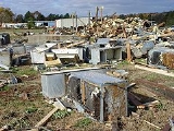
on November 27 – November 28, 2005. The outbreak spawned 57 tornadoes over a two-day period; 49 on November 27, and 8 more on November 28. A motorist was killed while struck by a tornado on I-40 in Conway County, Arkansas, and a man was killed in Ripley County, Missouri
when the top floor of a two-story home was torn off by an F2 tornado
. Power was lost to several thousand homes, and some roads were temporarily impassable due to debris from the tornadoes.
It was the fourth major outbreak of the unusually active month; the other three occurring on November 6
, 12
and 15
.
In addition, the same system produced a major blizzard
in the northern and western Great Plains
.
Tornado outbreak
While there is no single agreed upon definition, generally at least 6-10 tornadoes produced by the same synoptic scale weather system is considered a tornado outbreak. The tornadoes usually occur within the same day, or continue into the early morning hours of the succeeding day, and within the...
that affected the Central United States
Central United States
The Central United States is sometimes conceived as between the Eastern United States and Western United States as part of a three-region model, roughly coincident with the Midwestern United States plus the western and central portions of the Southern United States; the term is also sometimes used...
on November 27 – November 28, 2005. The outbreak spawned 57 tornadoes over a two-day period; 49 on November 27, and 8 more on November 28. A motorist was killed while struck by a tornado on I-40 in Conway County, Arkansas, and a man was killed in Ripley County, Missouri
Ripley County, Missouri
Ripley County is a county located in the Ozarks of Southeast Missouri in the United States. As of the 2000 U.S. Census, the county's population was 13,509. A 2008 estimate, however, showed the population to be 13,485. The largest city and county seat is Doniphan...
when the top floor of a two-story home was torn off by an F2 tornado
Fujita scale
The Fujita scale , or Fujita-Pearson scale, is a scale for rating tornado intensity, based primarily on the damage tornadoes inflict on human-built structures and vegetation...
. Power was lost to several thousand homes, and some roads were temporarily impassable due to debris from the tornadoes.
It was the fourth major outbreak of the unusually active month; the other three occurring on November 6
Evansville Tornado of November 2005
- Evansville area tornado :On Sunday, November 6, 2005 at around 1:50 am CST , a tornado touched down 2 miles north-northwest of Smith Mills in Henderson County, Kentucky, near the Indiana/Kentucky border, and then crossed the Ohio River into Vanderburgh County, Indiana...
, 12
Iowa Tornado Outbreak of November 2005
The Iowa Tornado Outbreak of November 2005 was a large and exceptionally rare late autumn season tornado outbreak on the afternoon and evening of November 12, 2005 across the central United States but concentrated in central Iowa. At least one person was killed and there was extensive damage in...
and 15
Mid-November 2005 Tornado Outbreak
The Mid-November 2005 outbreak was an unseasonably strong tornado outbreak on November 15, 2005 in the central United States. It occurred along a cold front separating warm, humid air from the southeast from cold Arctic air to the north and northwest...
.
In addition, the same system produced a major blizzard
Blizzard
A blizzard is a severe snowstorm characterized by strong winds. By definition, the difference between blizzard and a snowstorm is the strength of the wind. To be a blizzard, a snow storm must have winds in excess of with blowing or drifting snow which reduces visibility to 400 meters or ¼ mile or...
in the northern and western Great Plains
Great Plains
The Great Plains are a broad expanse of flat land, much of it covered in prairie, steppe and grassland, which lies west of the Mississippi River and east of the Rocky Mountains in the United States and Canada. This area covers parts of the U.S...
.
November 27
Fujita scale The Fujita scale , or Fujita-Pearson scale, is a scale for rating tornado intensity, based primarily on the damage tornadoes inflict on human-built structures and vegetation... |
|
|
|
|
|
|
| Kansas Kansas Kansas is a US state located in the Midwestern United States. It is named after the Kansas River which flows through it, which in turn was named after the Kansa Native American tribe, which inhabited the area. The tribe's name is often said to mean "people of the wind" or "people of the south... |
||||||
| F0 | NE of Marion Marion, Kansas Marion is a city in and the county seat of Marion County, Kansas, United States. It was named in honor of Francis Marion, a Brigadier General of the American Revolutionary War, known as the "Swamp Fox". As of the 2010 census, the city population was 1,927.... |
Marion Marion County, Kansas Marion County is a county located in the U.S. state of Kansas. As of the 2010 census, the county population was 12,660. The county seat is Marion... |
38°22′N 96°59′W | 1948 | 0.1 mile (0.160934 km) | |
| F0 | NW of Marion Marion, Kansas Marion is a city in and the county seat of Marion County, Kansas, United States. It was named in honor of Francis Marion, a Brigadier General of the American Revolutionary War, known as the "Swamp Fox". As of the 2010 census, the city population was 1,927.... |
Marion Marion County, Kansas Marion County is a county located in the U.S. state of Kansas. As of the 2010 census, the county population was 12,660. The county seat is Marion... |
38°23′N 97°03′W | 1948 | 13 miles (20.9 km) | |
| F0 | NE of Marion Marion, Kansas Marion is a city in and the county seat of Marion County, Kansas, United States. It was named in honor of Francis Marion, a Brigadier General of the American Revolutionary War, known as the "Swamp Fox". As of the 2010 census, the city population was 1,927.... |
Marion Marion County, Kansas Marion County is a county located in the U.S. state of Kansas. As of the 2010 census, the county population was 12,660. The county seat is Marion... |
38°26′N 96°55′W | 1950 | 2 miles (3.2 km) | |
| F0 | NE of Lincolnville Lincolnville, Kansas Lincolnville is a city in Marion County, Kansas, United States. As of the 2010 census, the city population was 203.-19th century:For millennia, the land that is currently Kansas was inhabited by Native Americans. In 1803, most of modern Kansas was secured by the United States as part of the... |
Marion Marion County, Kansas Marion County is a county located in the U.S. state of Kansas. As of the 2010 census, the county population was 12,660. The county seat is Marion... |
38°31′N 96°56′W | 2004 | 0.1 mile (0.160934 km) | |
| F0 | SW of Burdick Burdick, Kansas Burdick is an unincorporated community in southwestern Morris County, Kansas, United States. It lies along local roads south-southwest of the city of Council Grove, the county seat of Morris County. Its elevation is 1,453 feet , and it is located at... |
Marion Marion County, Kansas Marion County is a county located in the U.S. state of Kansas. As of the 2010 census, the county population was 12,660. The county seat is Marion... |
38°33′N 96°51′W | 2005 | 3 miles (4.8 km) | |
| F1 | Delavan area | Morris Morris County, Kansas Morris County is a county located in the U.S. state of Kansas. As of the 2010 census, the county population was 5,923. The largest city and county seat is Council Grove.-19th century:... , Geary Geary County, Kansas Geary County is a county located in Northeast Kansas, in the Central United States. As of the 2010 census, the county population was 34,362. Its county seat and most populous city is Junction City. The county is named in honor of Governor John W. Geary... |
38°38′N 96°49′W | 2012 | 20 miles (32.2 km) | Some damage reported along 400 yard (360 m) wide path. Intermittent touchdowns reported by county sheriff Sheriff A sheriff is in principle a legal official with responsibility for a county. In practice, the specific combination of legal, political, and ceremonial duties of a sheriff varies greatly from country to country.... . |
| F0 | S of Chapman Chapman, Kansas Chapman is a city in Dickinson County, Kansas, United States. As of the 2010 census, the city population was 1,393.-History:The first settlement was made at Chapman in 1868, and the same year Jackman's mill was built on Chapman creek a little northeast of the present town. James Streeter and S. M... |
Dickinson Dickinson County, Kansas Dickinson County is a county located in Central Kansas, in the Central United States. As of the 2010 census, the county population was 19,754. Its county seat and most populous city is Abilene. It was named in honor of Daniel S. Dickinson.-19th century:In 1887, Mr. Herington successfully got... |
38°51′N 97°01′W | 2032 | 1.5 miles (2.4 km) | Remained in open country 8 miles (13 km) south of Chapman, no damage. |
| F0 | S of Wilsey Wilsey, Kansas Wilsey is a city in Morris County, Kansas, United States. As of the 2010 census, the city population was 153.-History:An agricultural-based community, Wilsey was named after pioneer John D. Wilsey. In the early 1880s, the Missouri Pacific Railroad was built through the county, at which time Wilsey... |
Morris Morris County, Kansas Morris County is a county located in the U.S. state of Kansas. As of the 2010 census, the county population was 5,923. The largest city and county seat is Council Grove.-19th century:... |
38°35′N 96°40′W | 2032 | 6 miles (9.7 km) | |
| F0 | SW of Hartford Hartford, Kansas Hartford is a city in Lyon County, Kansas, United States. As of the 2010 census, the city population was 371. It is part of the Emporia Micropolitan Statistical Area.-Geography:Hartford is located at... |
Lyon Lyon County, Kansas Lyon County is a county located in the U.S. state of Kansas. The county was named for General Nathaniel Lyon, who was killed at the Battle of Wilson's Creek in the Civil War. As of the 2010 census, the county population was 33,690. Emporia is the largest city and county seat... |
38°16′N 95°59′W | 2035 | 1 miles (1.6 km) | |
| F0 | Cherryvale Cherryvale, Kansas Cherryvale is a city in Montgomery County, Kansas, United States. The population was 2,386 at the 2000 census.-History:Cherryvale was founded on the land of the Osage Indians who were pushed out by veterans of the American Civil War looking for land. The first white man to purchase property and... area |
Montgomery Montgomery County, Kansas Montgomery County is a county located in southeast Kansas, in the Central United States. As of the 2010 census, the county population was 35,471. Its county seat is Independence, and its most populous city is Coffeyville. The Coffeyville Micropolitan Statistical Area includes all of Montgomery... |
37°17′N 95°32′W | 2048 | 0.1 mile (0.160934 km) | |
| F0 | N of Parkersville | Morris Morris County, Kansas Morris County is a county located in the U.S. state of Kansas. As of the 2010 census, the county population was 5,923. The largest city and county seat is Council Grove.-19th century:... |
38°49′N 96°39′W | 2058 | 0.25 mile (0.402335 km) | Second tornado reported north of Wilsey. No damage reported. |
| F1 | NE of Junction City Junction City, Kansas Junction City is a city in and the county seat of Geary County, Kansas, United States. As of the 2010 census, the city population was 23,353. Fort Riley, a major U.S. Army post, is nearby... |
Geary Geary County, Kansas Geary County is a county located in Northeast Kansas, in the Central United States. As of the 2010 census, the county population was 34,362. Its county seat and most populous city is Junction City. The county is named in honor of Governor John W. Geary... , Riley Riley County, Kansas Riley County is a county located in the U.S. state of Kansas. The county's population was 71,115 for the 2010 census. The largest city and county seat is Manhattan. The county is part of the Manhattan, Kansas, Metropolitan Statistical Area.Riley County is home to two of Kansas' largest... |
39°04′N 96°48′W | 2109 | 2 miles (3.2 km) | Traffic briefly blocked from Interstate 70 Interstate 70 Interstate 70 is an Interstate Highway in the United States that runs from Interstate 15 near Cove Fort, Utah, to a Park and Ride near Baltimore, Maryland. It was the first Interstate Highway project in the United States. I-70 approximately traces the path of U.S. Route 40 east of the Rocky... between Exits 290 and 295. |
| F0 | SE of Junction City Junction City, Kansas Junction City is a city in and the county seat of Geary County, Kansas, United States. As of the 2010 census, the city population was 23,353. Fort Riley, a major U.S. Army post, is nearby... |
Geary Geary County, Kansas Geary County is a county located in Northeast Kansas, in the Central United States. As of the 2010 census, the county population was 34,362. Its county seat and most populous city is Junction City. The county is named in honor of Governor John W. Geary... |
38°59′N 96°46′W | 2115 | 0.25 mile (0.402335 km) | |
| F0 | ESE of Junction City Junction City, Kansas Junction City is a city in and the county seat of Geary County, Kansas, United States. As of the 2010 census, the city population was 23,353. Fort Riley, a major U.S. Army post, is nearby... |
Geary Geary County, Kansas Geary County is a county located in Northeast Kansas, in the Central United States. As of the 2010 census, the county population was 34,362. Its county seat and most populous city is Junction City. The county is named in honor of Governor John W. Geary... |
39°01′N 96°46′W | 2121 | 2 miles (3.2 km) | |
| F0 | Keats area | Riley Riley County, Kansas Riley County is a county located in the U.S. state of Kansas. The county's population was 71,115 for the 2010 census. The largest city and county seat is Manhattan. The county is part of the Manhattan, Kansas, Metropolitan Statistical Area.Riley County is home to two of Kansas' largest... |
39°13′N 96°43′W | 2128 | 0.1 mile (0.160934 km) | |
| F0 | E of Riley Riley, Kansas Riley is a city in Riley County, Kansas, United States. As of the 2010 census, the city population was TBD. It is part of the Manhattan, Kansas Metropolitan Statistical Area.-Geography:Riley is located at... |
Riley Riley County, Kansas Riley County is a county located in the U.S. state of Kansas. The county's population was 71,115 for the 2010 census. The largest city and county seat is Manhattan. The county is part of the Manhattan, Kansas, Metropolitan Statistical Area.Riley County is home to two of Kansas' largest... |
39°18′N 96°47′W | 2132 | 0.1 mile (0.160934 km) | |
| F0 | N of Randolph Randolph, Kansas Randolph is a city in Riley County, Kansas, United States. As of the 2010 census, the city population was 163. It is part of the Manhattan, Kansas Metropolitan Statistical Area.-History:Randolph was originally located a mile east of its present location.... |
Riley Riley County, Kansas Riley County is a county located in the U.S. state of Kansas. The county's population was 71,115 for the 2010 census. The largest city and county seat is Manhattan. The county is part of the Manhattan, Kansas, Metropolitan Statistical Area.Riley County is home to two of Kansas' largest... |
39°29′N 96°46′W | 2149 | 0.1 mile (0.160934 km) | |
| F1 | NE of Erie Erie, Kansas Erie is a city in and the county seat of Neosho County, Kansas, United States, and situated in the valley of the Neosho River, about a mile Northeast of the river... |
Neosho Neosho County, Kansas Neosho County is a county located in the U.S. state of Kansas. As of the 2010 census, the county population was 16,512... |
37°35′N 95°13′W | 2206 | 6 miles (9.7 km) | |
| F0 | SE of Elsmore Elsmore, Kansas Elsmore is a city situated in the southeastern part of Allen County, located in southeast Kansas, in the Central United States. As of the 2010 census, the city population was 77.-History:... |
Allen Allen County, Kansas Allen County is a county located in southeast Kansas, in the central United States of America. As of the 2010 census, the county population was 13,371... |
37°46′N 95°07′W | 2222 | 0.1 mile (0.160934 km) | |
| Arkansas Arkansas Arkansas is a state located in the southern region of the United States. Its name is an Algonquian name of the Quapaw Indians. Arkansas shares borders with six states , and its eastern border is largely defined by the Mississippi River... |
||||||
| F1 | S of Bluffton Bluffton, Arkansas Bluffton is an unincorporated community in Yell County, Arkansas, United States. Bluffton is located on Arkansas Highway 28 west-southwest of Plainview. Bluffton has a post office with ZIP code 72827.... |
Yell Yell County, Arkansas Yell County is a county located in the U.S. state of Arkansas. As of 2010, the population was 22,185. The county has two county seats, Dardanelle and Danville... |
34°52′N 93°36′W | 2140 | 5 miles (8 km) | |
| F0 | SW of Danville Danville, Arkansas Danville is a city in Yell County, Arkansas, United States. The population was 2,392 at the 2000 census. Along with Dardanelle, it is one of two county seats for Yell County.Danville is part of the Russellville Micropolitan Statistical Area.-Geography:... |
Yell Yell County, Arkansas Yell County is a county located in the U.S. state of Arkansas. As of 2010, the population was 22,185. The county has two county seats, Dardanelle and Danville... |
35°00′N 93°26′W | 2157 | 2.7 miles (4.3 km) | |
| F1 | SSW of Kirby Kirby, Arkansas Kirby is an unincorporated census-designated place in northern Pike County, Arkansas, United States. The community lies on U.S. Route 70; it is located halfway between Daisy and Glenwood. As of the 2010 census, its population is 786.-References:... |
Pike Pike County, Arkansas Pike County is a county located in the U.S. state of Arkansas. As of 2010, the population was 11,291. The county seat is Murfreesboro. Pike County is Arkansas's 25th county, formed on November 1, 1833, and named for Lieutenant Zebulon Pike, the explorer who discovered Pikes Peak... , Montgomery Montgomery County, Arkansas Montgomery County is a county located in the U.S. state of Arkansas. As of 2010, the population was 9,487. The county seat is Mount Ida. Montgomery County is Arkansas's 45th county, formed on December 9, 1842, and named after Richard Montgomery, an American Revolutionary War... |
34°13′N 93°39′W | 2225 | 17 miles (27.4 km) | Numerous trees fell; roof damage was reported to 2 barns and a mobile home. |
| F1 | NNE of Welsh | Montgomery Montgomery County, Arkansas Montgomery County is a county located in the U.S. state of Arkansas. As of 2010, the population was 9,487. The county seat is Mount Ida. Montgomery County is Arkansas's 45th county, formed on December 9, 1842, and named after Richard Montgomery, an American Revolutionary War... |
34°24′N 93°26′W | 2249 | 5 miles (8 km) | |
| F1 | SW of Crystal Springs Crystal Springs, Arkansas Crystal Springs is an unincorporated community in Garland County, Arkansas, United States. On April 25, 2011, a tornado associated with the April 25–28, 2011 tornado outbreak hit the Crystal Springs area, destroying houses in nearby Sunshine.... |
Garland | 34°28′N 93°24′W | 2256 | 4 miles (6.4 km) | Damage to many trees, some power lines and a hay barn. Struggled to stay up at times in the hilly terrain. |
| F1 | N of Bear Bear, Arkansas Bear, Arkansas, formerly also called Bear City, Arkansas is a small unincorporated place in Garland County, Arkansas. It is close to the shore of Lake Ouachita which was formed by the building of the Blakely Mountain Dam arcoss the Ouachita River. Up until some point in the early 20th century... |
Garland | 34°34′N 93°16′W | 2310 | 1 miles (1.6 km) | |
| F2 | SE of Bonnerdale Bonnerdale, Arkansas Bonnerdale is an unincorporated community in Hot Spring County, Arkansas, United States. Bonnerdale is located on U.S. Route 70 in far western Hot Spring County, east-northeast of Glenwood. Bonnerdale has a post office with ZIP code 71933.... |
Hot Spring, Garland | 34°21′N 93°21′W | 2310 | 18 miles (29 km) | One mobile home destroyed. Structural damage to a brick house and lesser damage to many other buildings. Many trees and power lines were knocked down. |
| F1 | ESE of Chimes | Garland, Searcy | 34°44′N 93°07′W | 2321 | 6 miles (9.7 km) | |
| F1 | NE of Jessieville | Van Buren, Saline | 35°42′N 92°43′W | 2330 | 8 miles (12.9 km) | |
| F2 | WSW of Morrilton Morrilton, Arkansas Morrilton is a city in Conway County, Arkansas, United States, northwest of Little Rock. The town was home to Harding College, now Harding University of Searcy, Arkansas, for about a decade in the 1920s and 1930s. The population was 6,550 at the 2000 census... |
Conway, Pope | 35°42′N 92°43′W | 2337 | 18 miles (29 km) | Heavy damage to several buildings, including a liquor store Liquor store In the United States, Australia and Canada, a liquor store is a type of store that specializes in the sale of alcoholic beverages. In South Africa and Namibia these stores are generally called bottle stores.... . |
| F3 | SW of Thornburg | Perry, Conway | 34°49′N 92°56′W | 2341 | 21 miles (33.8 km) | Significant damage in Cherry Hill and near Oppelo Oppelo, Arkansas Oppelo is a city in Conway County, Arkansas, United States. The population was 725 at the 2000 census.-Geography:Oppelo is located at .... . A lumber mill was destroyed. |
| F3 | Plumerville Plumerville, Arkansas Plumerville is a city in Conway County, Arkansas, United States. The population was 854 at the 2000 census.-Geography:Plumerville is located at .According to the United States Census Bureau, the city has a total area of , all land.... area |
Conway | 35°07′N 92°43′W | 0009 | 15 miles (24.1 km) | 1 death - Strongest tornado of the outbreak. Track crossed Interstate 40 Interstate 40 Interstate 40 is the third-longest major east–west Interstate Highway in the United States, after I-90 and I-80. Its western end is at Interstate 15 in Barstow, California; its eastern end is at a concurrency of U.S. Route 117 and North Carolina Highway 132 in Wilmington, North Carolina... at milepost 111. Many cars were overturned, killing one motorist. Many homes suffered significant damage as well. |
| F1 | ESE of Buford Buford, Arkansas Buford is an unincorporated community in Baxter County, Arkansas, United States. It is the location of Buford School Building, which is located on AR 126 and is listed on the National Register of Historic Places.-References:... |
Baxter Baxter County, Arkansas Baxter County is a county located in the U.S. state of Arkansas. It is in the northern part of the state, and shares a border with Missouri. It is commonly referred to as the Twin Lakes Area because it is bordered by two of Arkansas' largest lakes, Bull Shoals Lake and Norfork Lake... |
36°14′N 92°24′W | 0015 | 4 miles (6.4 km) | |
| F1 | S of Williams Junction | Perry, Pulaski | 34°52′N 92°46′W | 0025 | 3 miles (4.8 km) | |
| F2 | Springfield Springfield, Arkansas Springfield is an unincorporated community located in the north central part of Arkansas in Conway County.-Notes:... area |
Conway, Faulkner, Van Buren | 35°17′N 92°34′W | 0027 | 22 miles (35.4 km) | |
| F1 | NNW of Vidette | Fulton, Ozark (MO) Ozark County, Missouri Ozark County is a county located in South Central Missouri in the United States. As of the 2000 U.S. Census, the county's population was 9,542. A 2008 estimate, however, showed the population to be 9,227. The largest city and county seat is Gainesville. From 1843 to 1845 the county was called... , Howell (MO) Howell County, Missouri Howell County is a county located in South Central Missouri in the United States. As of the 2010 U.S. Census, the county's population was 40,400. The largest city and county seat is West Plains... |
36°29′N 92°09′W | 0040 | 7 miles (11.3 km) | |
| F1 | SSW of Shirley Shirley, Arkansas Shirley is a town in northeast Van Buren County, Arkansas, United States, along the Middle Fork of the Little Red River. A one-time railroad outpost, the community today is oriented toward agriculture, particularly its cultivation of shiitake mushrooms.... |
Van Buren | 35°34′N 92°21′W | 0055 | 4 miles (6.4 km) | |
| F1 | S of Wooster Wooster, Arkansas Wooster is a town in Faulkner County, Arkansas, United States. The population was 516 at the 2000 census. It is part of the Little Rock–North Little Rock–Conway Metropolitan Statistical Area.-Geography:... |
Faulkner | 35°10′N 92°28′W | 0059 | 8 miles (12.9 km) | |
| F1 | S of Higden Higden, Arkansas Higden is a town in Cleburne County, Arkansas, United States. The population was 101 at the 2000 census.-Geography:Higden is located at .... |
Cleburne | 35°31′N 92°16′W | 0102 | 3 miles (4.8 km) | |
| F1 | NE of Greenbrier Greenbrier, Arkansas Greenbrier is a city in Faulkner County, Arkansas, United States. It is part of the Little Rock–North Little Rock–Conway Metropolitan Statistical Area. The population was 4,706 in the 2010 U.S. Census.- History :... |
Faulkner | 35°16′N 92°21′W | 0111 | 4 miles (6.4 km) | |
| F2 | NE of Bee Branch Bee Branch, Arkansas Bee Branch is an unincorporated community in Van Buren County, Arkansas, U.S.A.. The community is located near secondary roads and no Interstate highways in the immediate area. U.S. Route 65 is the most major highway to go through Bee Branch. The elevation of Bee Branch is above sea level and its... |
Van Buren, Cleburne | 35°21′N 92°17′W | 0119 | 10 miles (16.1 km) | |
| F0 | ESE of Prim Prim, Arkansas Prim is an unincorporated community in Cleburne County, Arkansas, United States. Prim is located at the junction of Arkansas Highway 225 and Arkansas Highway 263 north-northeast of Greers Ferry. Prim has a post office with ZIP code 72130.... |
Cleburne | 35°41′N 92°04′W | 0147 | 1 miles (1.6 km) | |
| F1 | ENE of Franklin Franklin, Arkansas Franklin is a town in Izard County, Arkansas, United States. The population was 184 at the 2000 census.-Geography:Franklin is located at .... |
Izard, Sharp Sharp County, Arkansas -External links:*... , Fulton |
36°11′N 91°45′W | 0155 | 12 miles (19.3 km) | |
| F2 | W of Marcella Marcella, Arkansas Marcella is an unincorporated community in Stone County, Arkansas, United States. Marcella is located along Arkansas Highway 14 east-southeast of Mountain View. Marcella has a post office with ZIP code 72555.... |
Stone | 35°47′N 91°57′W | 0205 | 7 miles (11.3 km) | |
| F1 | Pangburn Pangburn, Arkansas Pangburn is a city in White County, Arkansas, United States. The population was 654 at the 2000 census.-Geography:Pangburn is located at .According to the United States Census Bureau, the city has a total area of , all land.... area |
White White County, Arkansas White County is a county located in the U.S. state of Arkansas. As of 2010, the population was 77,076. The county seat is Searcy. White County is Arkansas's 31st county, formed on October 23, 1835, from portions of Independence, Jackson, and Pulaski counties and named for Hugh Lawson White, a... |
35°25′N 91°51′W | 0244 | 2 miles (3.2 km) | |
| Missouri Missouri Missouri is a US state located in the Midwestern United States, bordered by Iowa, Illinois, Kentucky, Tennessee, Arkansas, Oklahoma, Kansas and Nebraska. With a 2010 population of 5,988,927, Missouri is the 18th most populous state in the nation and the fifth most populous in the Midwest. It... |
||||||
| F0 | W of Dudenville Dudenville, Missouri Dudenville is an unincorporated community in Dade and Jasper counties in the U.S. state of Missouri... |
Jasper Jasper County, Missouri Jasper County is a county located in the US state of Missouri. It is included in the Joplin, Missouri Metropolitan Statistical Area. The 2010 total population of Jasper County was 117,404. It is the ninth most populous county in Missouri. Its county seat is Carthage, making it one of the few... |
37°20′N 94°05′W | 2320 | 0.1 mile (0.160934 km) | Tornado remained in open country. No damage reported. |
| F1 | Lawson Lawson, Missouri Lawson is a city in Clay and Ray counties in the U.S. state of Missouri. The population was 2,473 at the 2010 census.-Geography:Lawson is located at .... area |
Clay, Ray | 39°19′N 94°15′W | 2344 | 13 miles (20.9 km) | Damage reported to several farm and industrial buildings, mainly partially collapsed roofs. Many trees were damaged along its 75 to 100 yard (70 to 90 m) wide path. Debris was reported near the intersection of US 69 and Highway D. |
| F1 | SE of Pottersville Pottersville, Missouri Pottersville is an unincorporated community in Howell County, Missouri. It is located about ten miles west of West Plains.... |
Howell Howell County, Missouri Howell County is a county located in South Central Missouri in the United States. As of the 2010 U.S. Census, the county's population was 40,400. The largest city and county seat is West Plains... |
36°40′N 92°00′W | 0056 | 5 miles (8 km) | |
| F2 | Briar Briar, Missouri Briar is an unincorporated community in Ripley County, Missouri. It is located on U.S. Route 160 about seven miles west of Doniphan.... area |
Ripley Ripley County, Missouri Ripley County is a county located in the Ozarks of Southeast Missouri in the United States. As of the 2000 U.S. Census, the county's population was 13,509. A 2008 estimate, however, showed the population to be 13,485. The largest city and county seat is Doniphan... |
36°32′N 91°06′W | 0230 | 12 miles (19.3 km) | 1 death - 140 mph tornado touched down 3 miles south of Gatewood and moved north/northeast and lifted 2.5 miles northwest of Briar. Destroyed a two story home and severely damaged two others near Briar. Man living inside home was fatally injured. One mobile home was also destroyed, with several others damaged. Also uprooted many trees along path in southwest Ripley County. |
| F0 | Maplewood Maplewood, Missouri Maplewood is an inner-ring suburb of St. Louis, located in St. Louis County. The population was 8,046 at the 2010 census.-Geography:Maplewood is located at .... area |
St. Louis | 38°37′N 90°20′W | 0505 | 1 miles (1.6 km) | Minor damage to roofs and windows, and some trees and power lines were knocked down. Some vehicles moved in a parking lot. There was also some other tree damage, including significant tree damage to homes, around Webster Groves Webster Groves, Missouri Webster Groves is an inner-ring suburb of St. Louis, located in St. Louis County, Missouri, United States. The population was 22,995 at the 2010 census. The city is named after New England politician Daniel Webster.... preceding the path of this tornado as well. |
November 28
Fujita scale The Fujita scale , or Fujita-Pearson scale, is a scale for rating tornado intensity, based primarily on the damage tornadoes inflict on human-built structures and vegetation... |
|
|
|
|
|
|
| Louisiana Louisiana Louisiana is a state located in the southern region of the United States of America. Its capital is Baton Rouge and largest city is New Orleans. Louisiana is the only state in the U.S. with political subdivisions termed parishes, which are local governments equivalent to counties... |
||||||
| F0 | SSE of Pioneer Pioneer, Louisiana Pioneer is a village in West Carroll Parish, Louisiana, United States. The population was 171 at the 2000 census.Former Louisiana Agriculture Commissoner Dave L... |
West Carroll West Carroll Parish, Louisiana West Carroll Parish is a parish located in the U.S. state of Louisiana. The parish seat is Oak Grove and as of 2000, the population was 12,314.-History:... |
32°44′N 91°25′W | 0724 | 1 miles (1.6 km) | A brief tornado touched down near Pioneer. The tin roof of a ship was torn off and blown into a wooded area nearby. One home also had shingles blown off its roof. No injuries were reported as a result of the tornado and damages amounted to $50,000. |
| Mississippi Mississippi Mississippi is a U.S. state located in the Southern United States. Jackson is the state capital and largest city. The name of the state derives from the Mississippi River, which flows along its western boundary, whose name comes from the Ojibwe word misi-ziibi... |
||||||
| F0 | Glen Allan Glen Allan, Mississippi Glen Allan is an unincorporated community located in far southern Washington County, Mississippi, United States. It is situated immediately east of Lake Washington's southern shore.... area |
Washington Washington County, Mississippi -National protected areas:*Holt Collier National Wildlife Refuge*Theodore Roosevelt National Wildlife Refuge *Yazoo National Wildlife Refuge-Demographics:... |
33°01′N 91°01′W | 0756 | 1 miles (1.6 km) | A brief tornado damaged part of the roof of a church before damaging the porch of a nearby house. Several trees were also downed along the tornado's 1 miles (1.6 km) path. No injuries were reported as a result of the tornado and damages amounted to $50,000. |
| Alabama Alabama Alabama is a state located in the southeastern region of the United States. It is bordered by Tennessee to the north, Georgia to the east, Florida and the Gulf of Mexico to the south, and Mississippi to the west. Alabama ranks 30th in total land area and ranks second in the size of its inland... |
||||||
| F0 | N of Graysville Graysville, Alabama Graysville is a city in Jefferson County, Alabama, United States. It is part of the Birmingham–Hoover–Cullman Combined Statistical Area. At the 2000 census the population was 2,344.-Geography:Graysville is located at .... |
Jefferson Jefferson County, Alabama Jefferson County is the most populous county in the U.S. state of Alabama, with its county seat being located in Birmingham.As of the 2010 U.S. Census, the population of Jefferson County was 658,466... |
33°46′N 86°58′W | 1810 | 0.1 mile (0.160934 km) | A brief tornado touched down in the Bagley community around 2:10 pm CST. The 30 yard wide tornado was on the ground for less than a minute. Several trees were blown down and one home sustained roof damage and had its porch destroyed. No injuries were reported as a result of the tornado and damages amounted to $16,000. |
| F0 | NW of Hueytown Hueytown, Alabama Hueytown is a city in Jefferson County, Alabama, United States. At the 2010 census the population was 16,105.It was the home of the legendary NASCAR Alabama Gang... |
Jefferson Jefferson County, Alabama Jefferson County is the most populous county in the U.S. state of Alabama, with its county seat being located in Birmingham.As of the 2010 U.S. Census, the population of Jefferson County was 658,466... |
33°28′N 86°59′W | 1840 | 0.4 mile (0.643736 km) | A brief tornado touched down in the Concord community around 2:40 pm CST. The 75 yard wide tornado tracked for 0.4 mile (0.643736 km) before lifting. Five homes sustained roof damage, several sheds were overturned, and several trees were damaged or blown down. No injuries were reported as a result of the tornado and damages amounted to $39,000. |
| F0 | NW of Summerfield Summerfield, Alabama Summerfield is an unincorporated community in Dallas County, Alabama. Summerfield has one historic district included on the National Register of Historic Places, the Summerfield District. Most of the community was annexed into Valley Grande following its incorporation as a city in... |
Dallas Dallas County, Alabama Dallas County is a county of the U.S. state of Alabama. Its name is in honor of United States Secretary of the Treasury Alexander J. Dallas. The county seat is Selma.- History :... |
32°31′N 87°04′W | 2053 | 5.8 miles (9.3 km) | The third tornado to touch down in Alabama on November 28 occurred around 4:53 pm CST near Summerfield. The tornado tracked towards the northwest for 5.8 miles (9.3 km) over a 9 minute span. Numerous trees were snapped or uprooted along the tornado's path, a few homes sustained roof damage, and one mobile home was pushed off its foundation. No injuries were reported as a result of the tornado and damages amounted to $28,000. |
| F0 | W of Autaugaville Autaugaville, Alabama Autaugaville is a town in Autauga County, Alabama, United States. At the 2000 census the population was 820. According to the 2008 U.S. Census estimates, the town had a population of 870. It is part of the Montgomery Metropolitan Statistical Area.-Geography:... |
Autauga Autauga County, Alabama Autauga County is a county in the U.S. state of Alabama. As of the 2010 census the population was 54,571. Its county seat is Prattville.Autauga County is part of the Montgomery Metropolitan Statistical Area.-History:... |
32°26′N 86°43′W | 2241 | 5.4 miles (8.7 km) | |
| F0 | N of Wetumpka Wetumpka, Alabama Wetumpka is a city in Elmore County, Alabama, United States. At the 2000 census the population was 5,726.The city is the county seat of Elmore County, one of the fastest growing counties in the state.... |
Elmore Elmore County, Alabama Elmore County is a county of the State of Alabama. Its name is in honor of General John A. Elmore. As of 2010 its population was 79,303. Its county seat is Wetumpka.This county is part of the Montgomery Metropolitan Statistical Area.- History :... |
32°43′N 86°13′W | 2330 | 0.1 mile (0.160934 km) | |
| F1 | WSW of Equality Equality, Alabama Equality is an unincorporated community in Coosa County and Elmore County in Alabama, United States.Famous Residents/ Former Residents – Actress Pauley Perrette, who plays Abby in the highly acclaimed television series NCIS, once lived in Equality, Alabama. Ms... |
Coosa Coosa County, Alabama Coosa County is a county of the U.S. state of Alabama. Its name derives from a town of the Creek tribe. As of 2010 the population was 11,539, but since that time it has lost the most population by percentage of any Alabama county... |
32°44′N 86°09′W | 2344 | 0.4 mile (0.643736 km) | |
External links
- Nov 27 Preliminary storm reports via Storm Prediction Center
- Nov 28 Preliminary storm reports via Storm Prediction Center
- Little Rock, Arkansas NWS info
- Topeka, Kansas NWS info
- Wichita, Kansas NWS info
- Kansas City NWS info
- Springfield, Missouri NWS info
- Maplewood, Missouri Tornado (NWS St. Louis)
- Paducah, Kentucky NWS info
- Birmingham, Alabama NWS info
- Strong Cold Front Triggers High Winds, Wildfires and Tornadoes in Southern Plains and Southeast (NWS Southern Region Headquarters)