
Bartholomew County, Indiana
Encyclopedia
Bartholomew County is a county located in the U.S. state
of Indiana
, and determined by the U.S. Census Bureau
to include the mean center of U.S. population
in 1900. As of 2010, the population was 76,794. The county seat
is Columbus
.
It is part of the Columbus metropolitan statistical area which encompasses all of Bartholomew County.
, wounded at the Battle of Tippecanoe
. The site of the county seat was chosen on February 15, 1821 by a team of commissioners, who suggested the name Tiptona, in honor of John Tipton
; on March 20, the name Columbus was adopted.
It was designed by architect Isaac Hodgson
, who was born in Belfast, Ireland in 1826 and immigrated to the United States in 1848; he designed six Indiana courthouses, including the one in Henry County
.
The courthouse is built largely of brick and has mansard roofs typical of the Second Empire French style. Its asymmetrical "L" shape allows it to face two major streets in Columbus. The inscription indicating the commissioners, architect and date is high up on the east facade.
Today the Bartholomew County Veterans Memorial designed by American architect Charles Rose
sits adjacent to the Courthouse.
 According to the 2010 census, the county has a total area of 409.52 square miles (1,060.7 km²), of which 406.91 square miles (1,053.9 km²) (or 99.36%) is land and 2.62 square miles (6.8 km²) (or 0.64%) is water. Camp Atterbury
occupies the northwestern corner of the county.
, and by the Indiana Code
.
County Council: The county council is the legislative branch of the county government and controls all the spending and revenue collection in the county. Representatives are elected from county districts. The council members serve four year terms. They are responsible for setting salaries, the annual budget, and special spending. The council also has limited authority to impose local taxes, in the form of an income and property tax that is subject to state level approval, excise taxes, and service taxes.
Board of Commissioners: The executive body of the county is made of a board of commissioners. The commissioners are elected county-wide, in staggered terms, and each serves a four-year term. One of the commissioners, typically the most senior, serves as president. The commissioners are charged with executing the acts legislated by the council, collecting revenue, and managing the day-to-day functions of the county government.
Court: The county maintains a small claims court
that can handle some civil cases. The judge on the court is elected to a term of four years and must be a member of the Indiana Bar Association. The judge is assisted by a constable who is also elected to a four-year term. In some cases, court decisions can be appealed to the state level circuit court
.
County Officials: The county has several other elected offices, including sheriff
, coroner
, auditor, treasurer
, recorder
, surveyor
, and circuit court clerk
. Each of these elected officers serves a term of four years and oversees a different part of county government. Members elected to county government positions are required to declare a party
affiliation and to be residents of the county.
Bartholomew County is part of Indiana's 6th congressional district
and Indiana's 9th congressional district
; Indiana Senate
district 41; and Indiana House of Representatives
districts 57, 59 and 65.
of 2000, there were 71,435 people, 27,936 households, and 20,058 families residing in the county. The population density
was 176 people per square mile (68/km²). There were 29,853 housing units at an average density of 73 per square mile (28/km²). The racial makeup of the county was 94.17% White
, 1.83% Black
or African American
, 0.15% Native American
, 1.9% Asian
, 0.04% Pacific Islander
, 0.96% from other races
, and 0.95% from two or more races. 2.24% of the population were Hispanic
or Latino
of any race. 25.4% were of German
, 25.2% American
, 11.7% English
and 9.1% Irish
ancestry according to Census 2000.
There were 27,936 households out of which 33.9% had children under the age of 18 living with them, 58.6% were married couples
living together, 9.7% had a female householder with no husband present, and 28.2% were non-families. 24.0% of all households were made up of individuals and 8.8% had someone living alone who was 65 years of age or older. The average household size was 2.52 and the average family size was 2.98.
In the county the population was spread out with 26.5% under the age of 18, 7.7% from 18 to 24, 29.70% from 25 to 44, 24.0% from 45 to 64, and 12.1% who were 65 years of age or older. The median age was 36 years. For every 100 females there were 96.6 males. For every 100 females age 18 and over, there were 93.9 males.
The median income for a household in the county was $44,184, and the median income for a family was $52,097. Males had a median income of $38,350 versus $24,652 for females. The per capita income
for the county was $21,536. About 5.9% of families and 7.3% of the population were below the poverty line, including 9.20% of those under age 18 and 7.9% of those age 65 or over.
and the Flat Rock-Hawcreek School Corporation. The county's first tuition-free public charter school, the International School of Columbus, a middle school/high school, opened in 2009-10. The ISC is an International Baccalaureate World School offering the Diploma Program.
U.S. state
A U.S. state is any one of the 50 federated states of the United States of America that share sovereignty with the federal government. Because of this shared sovereignty, an American is a citizen both of the federal entity and of his or her state of domicile. Four states use the official title of...
of Indiana
Indiana
Indiana is a US state, admitted to the United States as the 19th on December 11, 1816. It is located in the Midwestern United States and Great Lakes Region. With 6,483,802 residents, the state is ranked 15th in population and 16th in population density. Indiana is ranked 38th in land area and is...
, and determined by the U.S. Census Bureau
United States Census Bureau
The United States Census Bureau is the government agency that is responsible for the United States Census. It also gathers other national demographic and economic data...
to include the mean center of U.S. population
Mean center of U.S. population
The mean center of U.S. population is determined by the United States Census Bureau from the results of each census. The Bureau defines it to be:...
in 1900. As of 2010, the population was 76,794. The county seat
County seat
A county seat is an administrative center, or seat of government, for a county or civil parish. The term is primarily used in the United States....
is Columbus
Columbus, Indiana
Columbus is a city in and the county seat of Bartholomew County, Indiana, United States. The population was 44,061 at the 2010 census, and the current mayor is Fred Armstrong. Located approximately 40 miles south of Indianapolis, on the east fork of the White River, it is the state's 20th largest...
.
It is part of the Columbus metropolitan statistical area which encompasses all of Bartholomew County.
History
Bartholomew County was formed February 12, 1821 and was named for Lt. Col. Joseph BartholomewLt. Col. Joseph Bartholomew
Joseph Bartholomew was a general in the Indiana Militia who is often referred to as General Joseph Bartholomew. He played an active role in the settling of the state of Indiana and in his later years was known for his work in politics. He was injured in the Battle of Tippecanoe. He died in...
, wounded at the Battle of Tippecanoe
Battle of Tippecanoe
The Battle of Tippecanoe was fought on November 7, 1811, between United States forces led by Governor William Henry Harrison of the Indiana Territory and Native American warriors associated with the Shawnee leader Tecumseh. Tecumseh and his brother Tenskwatawa were leaders of a confederacy of...
. The site of the county seat was chosen on February 15, 1821 by a team of commissioners, who suggested the name Tiptona, in honor of John Tipton
John Tipton
John Shields Tipton was an American politician.Tipton was born in what is now Sevier County, Tennessee. His father was killed by Native Americans. His great uncle, also named John, was a prominent man in the area...
; on March 20, the name Columbus was adopted.
Courthouse
The current Bartholomew County courthouse was built from 1870 to 1874 by McCormack and Sweeney of Columbus at a cost of $225,000.It was designed by architect Isaac Hodgson
Isaac Hodgson (architect)
Isaac Hodgson was an Irish-American architect who worked primarily in Indiana and Minnesota. He was born in Belfast, Ireland in 1826 and studied at the Royal Academy. He went to work for architect Sir Charles Lanyon at the age of 16...
, who was born in Belfast, Ireland in 1826 and immigrated to the United States in 1848; he designed six Indiana courthouses, including the one in Henry County
Henry County, Indiana
As of the census of 2000, there were 48,508 people, 19,486 households, and 13,971 families residing in the county. The population density was 124 people per square mile . There were 20,592 housing units at an average density of 52 per square mile...
.
The courthouse is built largely of brick and has mansard roofs typical of the Second Empire French style. Its asymmetrical "L" shape allows it to face two major streets in Columbus. The inscription indicating the commissioners, architect and date is high up on the east facade.
Today the Bartholomew County Veterans Memorial designed by American architect Charles Rose
Charles Rose (architect)
Charles Rose is an American architect whose designs reflect a sensitivity for landscape and the distinct characteristics of a building site – whether in rugged coastal settings or dense urban neighborhoods.-Awards:...
sits adjacent to the Courthouse.
Geography
Camp Atterbury
Camp Atterbury, near Edinburgh, Indiana, USA, is a training base of the Indiana National Guard. It was planned just months before the U.S. entry into World War II. Originally surveyed and researched by the Hurd Company, the present site was recommended to Congress in 1941. Construction commenced...
occupies the northwestern corner of the county.
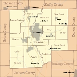
Adjacent counties
- Shelby CountyShelby County, IndianaAs of the census of 2000, there were 43,445 people, 16,561 households, and 12,056 families residing in the county. The population density was 105 people per square mile . There were 17,633 housing units at an average density of 43 per square mile...
(northeast) - Decatur CountyDecatur County, IndianaAs of the census of 2000, there were 24,555 people, 9,389 households, and 6,882 families residing in the county. The population density was 66 people per square mile . There were 9,992 housing units at an average density of 27 per square mile...
(east) - Jennings CountyJennings County, IndianaJennings County is a county located in the U.S. state of Indiana. As of 2010, the population was 28,525. The county seat is Vernon.-History:...
(southeast) - Jackson CountyJackson County, IndianaJackson County is a county located in the U.S. state of Indiana. As of 2010, the population was 42,376. The county seat is Brownstown.-History:...
(south) - Brown CountyBrown County, IndianaBrown County is a county located in the U.S. state of Indiana. As of 2010, the population is 15,242. The county seat is Nashville.- History :...
(west) - Johnson CountyJohnson County, IndianaAs of the census of 2000, there were 115,209 people, 42,434 households, and 31,613 families residing in the county. The population density was 360 people per square mile . There were 45,095 housing units at an average density of 141 per square mile...
(northwest)
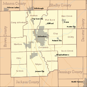
Cities and towns
|
Hartsville, Indiana Hartsville is a town in Haw Creek and Clifty townships, Bartholomew County, Indiana, United States. The population was 362 at the 2010 census. It is part of the Columbus, Indiana metropolitan statistical area.-Geography:... Hope, Indiana Hope is a town in Haw Creek Township, Bartholomew County, Indiana, United States. The population was 2,102 at the 2010 census. It is part of the Columbus, Indiana, metropolitan statistical area.-Geography:Hope is located at .... Jonesville, Indiana Jonesville is a town in Wayne Township, Bartholomew County, Indiana, United States. The population was 177 at the 2010 census. It is part of the Columbus, Indiana metropolitan statistical area.-Geography:Jonesville is located at .... Taylorsville, Indiana Taylorsville is a census-designated place in German Township, Bartholomew County, Indiana, United States. The population was 919 at the 2010 census... |
Unincorporated towns
|
Newbern, Indiana Newbern is an unincorporated town in Clifty Township, Bartholomew County, Indiana.... North Ogilville, Indiana North Ogilville is an unincorporated town in Ohio Township, Bartholomew County, Indiana.... Northcliff, Indiana Northcliff is an unincorporated town in Flat Rock Township, Bartholomew County, Indiana.... Nortonburg, Indiana Nortonburg is an unincorporated town in Flat Rock Township, Bartholomew County, Indiana.... Ogilville, Indiana Ogilville is an unincorporated town in Ohio Township, Bartholomew County, Indiana.... Old Saint Louis, Indiana Old Saint Louis is an unincorporated town in Haw Creek Township, Bartholomew County, Indiana.... Petersville, Indiana Petersville is an unincorporated town in Clay Township, Bartholomew County, Indiana.... |
Rosstown, Indiana Rosstown is an unincorporated town in Wayne Township, Bartholomew County, Indiana.... Rugby, Indiana Rugby is an unincorporated town in Haw Creek Township, Bartholomew County, Indiana.... Saint Louis Crossing, Indiana Saint Louis Crossing is an unincorporated town in Flat Rock Township, Bartholomew County, Indiana.... Stony Lonesome, Indiana Stony Lonesome is an unincorporated town in Harrison Township, Bartholomew County, Indiana.... Walesboro, Indiana Walesboro is an unincorporated town in Wayne Township, Bartholomew County, Indiana.-Geography:Walesboro is located at .The community is located on Indiana State Road 11 and is three miles east of Interstate 65.... Waymansville, Indiana Waymansville is an unincorporated town in Jackson Township, Bartholomew County, Indiana.... Waynesville, Indiana Waynesville is an unincorporated town in Wayne Township, Bartholomew County, Indiana.... |
Townships
|
German Township, Bartholomew County, Indiana German Township is one of twelve townships in Bartholomew County, Indiana, USA. As of the 2000 census, its population was 7,062.-Geography:According to the United States Census Bureau, German Township covers an area of ; of this, or 0.27 percent is water... Harrison Township, Bartholomew County, Indiana Harrison Township is one of twelve townships in Bartholomew County, Indiana, USA. As of the 2000 census, its population was 3,453.-Geography:... Haw Creek Township, Bartholomew County, Indiana Haw Creek Township is one of twelve townships in Bartholomew County, Indiana, USA. As of the 2000 census, its population was 4,015.-Geography:... Jackson Township, Bartholomew County, Indiana Jackson Township is one of twelve townships in Bartholomew County, Indiana, USA. As of the 2000 census, its population was 940.-Geography:According to the United States Census Bureau, Jackson Township covers an area of ; of this, or 0.89 percent is water.... |
Ohio Township, Bartholomew County, Indiana Ohio Township is one of twelve townships in Bartholomew County, Indiana, USA. As of the 2000 census, its population was 1,632.-Geography:According to the United States Census Bureau, Ohio Township covers an area of ; of this, or 2.1 percent is water.... Rock Creek Township, Bartholomew County, Indiana Rock Creek Township is one of twelve townships in Bartholomew County, Indiana, USA. As of the 2000 census, its population was 1,313.-Geography:... Sand Creek Township, Bartholomew County, Indiana Sand Creek Township is one of twelve townships in Bartholomew County, Indiana, USA. As of the 2000 census, its population was 2,185.-Geography:... Wayne Township, Bartholomew County, Indiana Wayne Township is one of twelve townships in Bartholomew County, Indiana, USA. As of the 2000 census, its population was 3,795.-Geography:According to the United States Census Bureau, Wayne Township covers an area of ; of this, or 0.75 percent is water.... |
Major highways
 Interstate 65Interstate 65Interstate 65 is a major Interstate Highway in the United States. The southern terminus is located at an intersection with Interstate 10 in Mobile, Alabama, and its northern terminus is at an interchange with Interstate 90 , U.S. Route 12, and U.S...
 U.S. Route 31U.S. Route 31U.S. Route 31 is a long north–south highway connecting northern Michigan to southern Alabama, with its northern terminus at Interstate 75 near Mackinaw City, Michigan, and southern terminus at the combined U.S. Route 90 & U.S. Route 98 at Spanish Fort, Alabama...
 Indiana State Road 7Indiana State Road 7State Road 7 in the U.S. State of Indiana is located in southeast Indiana. It runs from northwest-to-southeast connecting the cities of Columbus and Madison.-Route description:...
 Indiana State Road 9Indiana State Road 9State Road 9 in the U.S. State of Indiana is a long north–south state highway in the eastern portion of Indiana. Its southern terminus is near Columbus at State Road 46, and the northern terminus is at the Michigan/Indiana border between Howe, Indiana, and Sturgis, Michigan, where it...
 Indiana State Road 11Indiana State Road 11State Road 11 in the U.S. State of Indiana is located in south central Indiana and is divided into a northern and southern section. These sections were never connected.- Southern section :...
 Indiana State Road 46Indiana State Road 46State Road 46 in the U.S. State of Indiana is an east–west state highway in the southern half of Indiana.-Route description:The western terminus of SR 46 is at U.S. Route 40 in central Vigo County, just east of Terre Haute...
 Indiana State Road 58Indiana State Road 58State Road 58 is an east–west road in Central Indiana. State Road 58 runs from Merom in the west to Columbus in the east, a distance of approximately . Along its route it has concurrencies with one U.S. Route and six other Indiana state roads....
Climate and weather
In recent years, average temperatures in Columbus have ranged from a low of 19 °F (-7.2 °C) in January to a high of 86 °F (30 °C) in July, although a record low of -27 °F was recorded in January 1912 and a record high of 111 °F (43.9 °C) was recorded in July 1934. Average monthly precipitation ranged from 2.63 inches (6.7 cm) in February to 4.63 inches (11.8 cm) in May.Government
The county government is a constitutional body, and is granted specific powers by the Constitution of IndianaConstitution of Indiana
There have been two Constitutions of the State of Indiana. The first constitution was created when the Territory of Indiana sent forty-three delegates to a constitutional convention on June 10, 1816 to establish a constitution for the proposed State of Indiana after the United States Congress had...
, and by the Indiana Code
Indiana Code
The Indiana Code is the code of laws for the US State of Indiana. The contents are the codification of the all the laws currently in effect within Indiana...
.
County Council: The county council is the legislative branch of the county government and controls all the spending and revenue collection in the county. Representatives are elected from county districts. The council members serve four year terms. They are responsible for setting salaries, the annual budget, and special spending. The council also has limited authority to impose local taxes, in the form of an income and property tax that is subject to state level approval, excise taxes, and service taxes.
Board of Commissioners: The executive body of the county is made of a board of commissioners. The commissioners are elected county-wide, in staggered terms, and each serves a four-year term. One of the commissioners, typically the most senior, serves as president. The commissioners are charged with executing the acts legislated by the council, collecting revenue, and managing the day-to-day functions of the county government.
Court: The county maintains a small claims court
Small claims court
Small-claims courts have limited jurisdiction to hear civil cases between private litigants. Courts authorized to try small claims may also have other judicial functions, and the name by which such a court is known varies by jurisdiction; it may be known as a county or magistrate's court...
that can handle some civil cases. The judge on the court is elected to a term of four years and must be a member of the Indiana Bar Association. The judge is assisted by a constable who is also elected to a four-year term. In some cases, court decisions can be appealed to the state level circuit court
Circuit court
Circuit court is the name of court systems in several common law jurisdictions.-History:King Henry II instituted the custom of having judges ride around the countryside each year to hear appeals, rather than forcing everyone to bring their appeals to London...
.
County Officials: The county has several other elected offices, including sheriff
Sheriff
A sheriff is in principle a legal official with responsibility for a county. In practice, the specific combination of legal, political, and ceremonial duties of a sheriff varies greatly from country to country....
, coroner
Coroner
A coroner is a government official who* Investigates human deaths* Determines cause of death* Issues death certificates* Maintains death records* Responds to deaths in mass disasters* Identifies unknown dead* Other functions depending on local laws...
, auditor, treasurer
Treasurer
A treasurer is the person responsible for running the treasury of an organization. The adjective for a treasurer is normally "tresorial". The adjective "treasurial" normally means pertaining to a treasury, rather than the treasurer.-Government:...
, recorder
Recorder of deeds
Recorder of deeds is a government office tasked with maintaining public records and documents, especially records relating to real estate ownership that provide persons other than the owner of a property with real rights over that property.-Background:...
, surveyor
Surveying
See Also: Public Land Survey SystemSurveying or land surveying is the technique, profession, and science of accurately determining the terrestrial or three-dimensional position of points and the distances and angles between them...
, and circuit court clerk
Court clerk
A court clerk is an officer of the court whose responsibilities include maintaining the records of a court. Another duty is to administer oaths to witnesses, jurors, and grand jurors...
. Each of these elected officers serves a term of four years and oversees a different part of county government. Members elected to county government positions are required to declare a party
Political party
A political party is a political organization that typically seeks to influence government policy, usually by nominating their own candidates and trying to seat them in political office. Parties participate in electoral campaigns, educational outreach or protest actions...
affiliation and to be residents of the county.
Bartholomew County is part of Indiana's 6th congressional district
Indiana's 6th congressional district
Indiana's 6th congressional district is a congressional district in the U.S. state of Indiana. The district takes in a large portion of eastern Indiana, including Muncie, Anderson, and Richmond, as well as the suburbs of Fort Wayne, Cincinnati, and Indianapolis.The district is currently represented...
and Indiana's 9th congressional district
Indiana's 9th congressional district
Indiana's 9th congressional district is a congressional district in the U.S. state of Indiana. Located in south-central and southeastern Indiana, the district is based in Bloomington....
; Indiana Senate
Indiana Senate
The Indiana Senate is the upper house of the Indiana General Assembly, the state legislature of the U.S. state of Indiana. The Senate is composed of 50 members representing an equal number of constituent districts. Senators serve four-year terms without term limits...
district 41; and Indiana House of Representatives
Indiana House of Representatives
The Indiana House of Representatives is the lower house of the Indiana General Assembly, the state legislature of the U.S. state of Indiana. The House is composed of 100 members representing an equal number of constituent districts. House members serve two-year terms without term limits...
districts 57, 59 and 65.
Demographics
As of the censusCensus
A census is the procedure of systematically acquiring and recording information about the members of a given population. It is a regularly occurring and official count of a particular population. The term is used mostly in connection with national population and housing censuses; other common...
of 2000, there were 71,435 people, 27,936 households, and 20,058 families residing in the county. The population density
Population density
Population density is a measurement of population per unit area or unit volume. It is frequently applied to living organisms, and particularly to humans...
was 176 people per square mile (68/km²). There were 29,853 housing units at an average density of 73 per square mile (28/km²). The racial makeup of the county was 94.17% White
Race (United States Census)
Race and ethnicity in the United States Census, as defined by the Federal Office of Management and Budget and the United States Census Bureau, are self-identification data items in which residents choose the race or races with which they most closely identify, and indicate whether or not they are...
, 1.83% Black
Race (United States Census)
Race and ethnicity in the United States Census, as defined by the Federal Office of Management and Budget and the United States Census Bureau, are self-identification data items in which residents choose the race or races with which they most closely identify, and indicate whether or not they are...
or African American
Race (United States Census)
Race and ethnicity in the United States Census, as defined by the Federal Office of Management and Budget and the United States Census Bureau, are self-identification data items in which residents choose the race or races with which they most closely identify, and indicate whether or not they are...
, 0.15% Native American
Race (United States Census)
Race and ethnicity in the United States Census, as defined by the Federal Office of Management and Budget and the United States Census Bureau, are self-identification data items in which residents choose the race or races with which they most closely identify, and indicate whether or not they are...
, 1.9% Asian
Race (United States Census)
Race and ethnicity in the United States Census, as defined by the Federal Office of Management and Budget and the United States Census Bureau, are self-identification data items in which residents choose the race or races with which they most closely identify, and indicate whether or not they are...
, 0.04% Pacific Islander
Race (United States Census)
Race and ethnicity in the United States Census, as defined by the Federal Office of Management and Budget and the United States Census Bureau, are self-identification data items in which residents choose the race or races with which they most closely identify, and indicate whether or not they are...
, 0.96% from other races
Race (United States Census)
Race and ethnicity in the United States Census, as defined by the Federal Office of Management and Budget and the United States Census Bureau, are self-identification data items in which residents choose the race or races with which they most closely identify, and indicate whether or not they are...
, and 0.95% from two or more races. 2.24% of the population were Hispanic
Race (United States Census)
Race and ethnicity in the United States Census, as defined by the Federal Office of Management and Budget and the United States Census Bureau, are self-identification data items in which residents choose the race or races with which they most closely identify, and indicate whether or not they are...
or Latino
Race (United States Census)
Race and ethnicity in the United States Census, as defined by the Federal Office of Management and Budget and the United States Census Bureau, are self-identification data items in which residents choose the race or races with which they most closely identify, and indicate whether or not they are...
of any race. 25.4% were of German
Germans
The Germans are a Germanic ethnic group native to Central Europe. The English term Germans has referred to the German-speaking population of the Holy Roman Empire since the Late Middle Ages....
, 25.2% American
United States
The United States of America is a federal constitutional republic comprising fifty states and a federal district...
, 11.7% English
English people
The English are a nation and ethnic group native to England, who speak English. The English identity is of early mediaeval origin, when they were known in Old English as the Anglecynn. England is now a country of the United Kingdom, and the majority of English people in England are British Citizens...
and 9.1% Irish
Irish people
The Irish people are an ethnic group who originate in Ireland, an island in northwestern Europe. Ireland has been populated for around 9,000 years , with the Irish people's earliest ancestors recorded having legends of being descended from groups such as the Nemedians, Fomorians, Fir Bolg, Tuatha...
ancestry according to Census 2000.
There were 27,936 households out of which 33.9% had children under the age of 18 living with them, 58.6% were married couples
Marriage
Marriage is a social union or legal contract between people that creates kinship. It is an institution in which interpersonal relationships, usually intimate and sexual, are acknowledged in a variety of ways, depending on the culture or subculture in which it is found...
living together, 9.7% had a female householder with no husband present, and 28.2% were non-families. 24.0% of all households were made up of individuals and 8.8% had someone living alone who was 65 years of age or older. The average household size was 2.52 and the average family size was 2.98.
In the county the population was spread out with 26.5% under the age of 18, 7.7% from 18 to 24, 29.70% from 25 to 44, 24.0% from 45 to 64, and 12.1% who were 65 years of age or older. The median age was 36 years. For every 100 females there were 96.6 males. For every 100 females age 18 and over, there were 93.9 males.
The median income for a household in the county was $44,184, and the median income for a family was $52,097. Males had a median income of $38,350 versus $24,652 for females. The per capita income
Per capita income
Per capita income or income per person is a measure of mean income within an economic aggregate, such as a country or city. It is calculated by taking a measure of all sources of income in the aggregate and dividing it by the total population...
for the county was $21,536. About 5.9% of families and 7.3% of the population were below the poverty line, including 9.20% of those under age 18 and 7.9% of those age 65 or over.
Education
Public schools in Bartholomew County are administered by the Bartholomew Consolidated School CorporationBartholomew Consolidated School Corporation
Bartholomew Consolidated School Corporation is the organization that encompasses all schools, elementary, middle and secondary in the Columbus, Indiana area. The organization works to uphold and improve the educational standards of the community through the principles of Continuous Improvement,...
and the Flat Rock-Hawcreek School Corporation. The county's first tuition-free public charter school, the International School of Columbus, a middle school/high school, opened in 2009-10. The ISC is an International Baccalaureate World School offering the Diploma Program.