
Charlotte, Tennessee
Encyclopedia
Charlotte is a town in Dickson County, Tennessee
, United States
. The population was 1,153 at the 2000 census. It is the county seat
of Dickson County.
, nearly halfway between Dickson
and Ashland City
. A small stream known as Town Branch, which is part of the Cumberland River
watershed, flows through Charlotte from west-to-east.
Charlotte is centered around the junction of Tennessee State Route 49, which connects Charlotte with Ashland City
and Kentucky
to the northeast and upper West Tennessee to the northwest, and State Route 48, which connects the town to Dickson and U.S. Route 70
to the southwest and Clarksville
to the north.
According to the United States Census Bureau
, the town has a total area of 1.7 square miles (4.4 km²), all of it land.
of 2000, there were 1,153 people, 395 households, and 272 families residing in the town. The population density
was 661.0 people per square mile (255.8/km²). There were 413 housing units at an average density of 236.8 per square mile (91.6/km²). The racial makeup of the town was 86.82% White, 10.67% African American, 0.35% Native American, 0.17% Asian, 0.09% Pacific Islander, 0.26% from other races
, and 1.65% from two or more races. Hispanic or Latino of any race were 1.21% of the population.
 There were 395 households out of which 30.1% had children under the age of 18 living with them, 52.2% were married couples
living together, 11.9% had a female householder with no husband present, and 31.1% were non-families. 26.8% of all households were made up of individuals and 12.4% had someone living alone who was 65 years of age or older. The average household size was 2.50 and the average family size was 3.03.
In the town the population was spread out with 21.9% under the age of 18, 10.0% from 18 to 24, 35.5% from 25 to 44, 20.3% from 45 to 64, and 12.3% who were 65 years of age or older. The median age was 34 years. For every 100 females there were 111.9 males. For every 100 females age 18 and over, there were 120.0 males.
The median income for a household in the town was $32,279, and the median income for a family was $40,795. Males had a median income of $30,172 versus $21,442 for females. The per capita income
for the town was $15,061. About 7.0% of families and 10.6% of the population were below the poverty line, including 18.4% of those under age 18 and 14.4% of those age 65 or over.
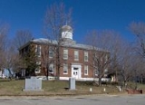
On May 30, 1830, a tornado destroyed most of downtown Charlotte. The roof of the courthouse was found 13 miles (20.9 km) away, and most of the county's early records were permanently lost. A new courthouse was completed in 1833, and still stands as the oldest functioning courthouse in the state of Tennessee. While Charlotte thrived as a stage coach hub for much of the 19th-century, the arrival of the railroad in the latter half of the century shifted the area's industrial focus to Dickson, several miles to the southwest.
Tennessee
Tennessee is a U.S. state located in the Southeastern United States. It has a population of 6,346,105, making it the nation's 17th-largest state by population, and covers , making it the 36th-largest by total land area...
, United States
United States
The United States of America is a federal constitutional republic comprising fifty states and a federal district...
. The population was 1,153 at the 2000 census. It is the county seat
County seat
A county seat is an administrative center, or seat of government, for a county or civil parish. The term is primarily used in the United States....
of Dickson County.
Geography
Charlotte is located at 36°10′44"N 87°20′39"W (36.178784, -87.344304). The town is situated amidst the hills that comprise part of the western section of the Highland RimHighland Rim
The Highland Rim is a geographic term for the area in Tennessee surrounding the Central Basin. Nashville is largely surrounded by higher terrain in all directions....
, nearly halfway between Dickson
Dickson, Tennessee
Dickson is a city in Dickson County, Tennessee, United States. It is part of the Nashville Metropolitan Statistical Area. The population was 12,244 at the 2000 census.-Demographics:...
and Ashland City
Ashland City, Tennessee
Ashland City is a town in Cheatham County, Tennessee, United States. The population was 3,641 at the 2000 census. It is the county seat of Cheatham County.-History:Ashland City was created in 1856 as a county seat for the newly-established Cheatham County...
. A small stream known as Town Branch, which is part of the Cumberland River
Cumberland River
The Cumberland River is a waterway in the Southern United States. It is long. It starts in Harlan County in far southeastern Kentucky between Pine and Cumberland mountains, flows through southern Kentucky, crosses into northern Tennessee, and then curves back up into western Kentucky before...
watershed, flows through Charlotte from west-to-east.
Charlotte is centered around the junction of Tennessee State Route 49, which connects Charlotte with Ashland City
Ashland City, Tennessee
Ashland City is a town in Cheatham County, Tennessee, United States. The population was 3,641 at the 2000 census. It is the county seat of Cheatham County.-History:Ashland City was created in 1856 as a county seat for the newly-established Cheatham County...
and Kentucky
Kentucky
The Commonwealth of Kentucky is a state located in the East Central United States of America. As classified by the United States Census Bureau, Kentucky is a Southern state, more specifically in the East South Central region. Kentucky is one of four U.S. states constituted as a commonwealth...
to the northeast and upper West Tennessee to the northwest, and State Route 48, which connects the town to Dickson and U.S. Route 70
U.S. Route 70
U.S. Route 70 is an east–west United States highway that runs for 2,385 miles from eastern North Carolina to east-central Arizona. As can be derived from its number, it is a major east–west highway of the Southern and Southwestern United States...
to the southwest and Clarksville
Clarksville, Tennessee
Clarksville is a city in and the county seat of Montgomery County, Tennessee, United States, and the fifth largest city in the state. The population was 132,929 in 2010 United States Census...
to the north.
According to the United States Census Bureau
United States Census Bureau
The United States Census Bureau is the government agency that is responsible for the United States Census. It also gathers other national demographic and economic data...
, the town has a total area of 1.7 square miles (4.4 km²), all of it land.
Demographics
As of the censusCensus
A census is the procedure of systematically acquiring and recording information about the members of a given population. It is a regularly occurring and official count of a particular population. The term is used mostly in connection with national population and housing censuses; other common...
of 2000, there were 1,153 people, 395 households, and 272 families residing in the town. The population density
Population density
Population density is a measurement of population per unit area or unit volume. It is frequently applied to living organisms, and particularly to humans...
was 661.0 people per square mile (255.8/km²). There were 413 housing units at an average density of 236.8 per square mile (91.6/km²). The racial makeup of the town was 86.82% White, 10.67% African American, 0.35% Native American, 0.17% Asian, 0.09% Pacific Islander, 0.26% from other races
Race (United States Census)
Race and ethnicity in the United States Census, as defined by the Federal Office of Management and Budget and the United States Census Bureau, are self-identification data items in which residents choose the race or races with which they most closely identify, and indicate whether or not they are...
, and 1.65% from two or more races. Hispanic or Latino of any race were 1.21% of the population.
Marriage
Marriage is a social union or legal contract between people that creates kinship. It is an institution in which interpersonal relationships, usually intimate and sexual, are acknowledged in a variety of ways, depending on the culture or subculture in which it is found...
living together, 11.9% had a female householder with no husband present, and 31.1% were non-families. 26.8% of all households were made up of individuals and 12.4% had someone living alone who was 65 years of age or older. The average household size was 2.50 and the average family size was 3.03.
In the town the population was spread out with 21.9% under the age of 18, 10.0% from 18 to 24, 35.5% from 25 to 44, 20.3% from 45 to 64, and 12.3% who were 65 years of age or older. The median age was 34 years. For every 100 females there were 111.9 males. For every 100 females age 18 and over, there were 120.0 males.
The median income for a household in the town was $32,279, and the median income for a family was $40,795. Males had a median income of $30,172 versus $21,442 for females. The per capita income
Per capita income
Per capita income or income per person is a measure of mean income within an economic aggregate, such as a country or city. It is calculated by taking a measure of all sources of income in the aggregate and dividing it by the total population...
for the town was $15,061. About 7.0% of families and 10.6% of the population were below the poverty line, including 18.4% of those under age 18 and 14.4% of those age 65 or over.
History
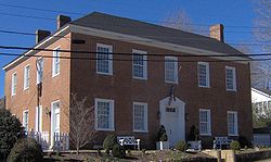
Charlotte was established in 1808 as the county seat for Dickson County, which had been created in 1803. The town was named for Charlotte Reeves Robertson, the wife of General James Robertson, who played prominent roles in the settlement of Middle Tennessee. Charlotte was officially incorporated in 1837.On May 30, 1830, a tornado destroyed most of downtown Charlotte. The roof of the courthouse was found 13 miles (20.9 km) away, and most of the county's early records were permanently lost. A new courthouse was completed in 1833, and still stands as the oldest functioning courthouse in the state of Tennessee. While Charlotte thrived as a stage coach hub for much of the 19th-century, the arrival of the railroad in the latter half of the century shifted the area's industrial focus to Dickson, several miles to the southwest.