
Grant County, Indiana
Overview
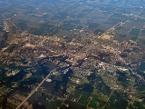
Grant County is a county located in the U.S. state
of Indiana
. As of the 2010 census, the population was 70,061. The county seat
is Marion
. Important paleontological
discoveries dating from the Pliocene
epoch have been made at Pipe Creek Sinkhole
in Grant County.
According to the 2010 census, the county has a total area of 414.9 square miles (1,074.6 km²), of which 414.07 square miles (1,072.4 km²) (or 99.80%) is land and 0.82 square miles (2.1 km²) (or 0.20%) is water.
Grant County, Indiana, is one of the few counties in the United States to border as many as nine counties.
U.S. state
A U.S. state is any one of the 50 federated states of the United States of America that share sovereignty with the federal government. Because of this shared sovereignty, an American is a citizen both of the federal entity and of his or her state of domicile. Four states use the official title of...
of Indiana
Indiana
Indiana is a US state, admitted to the United States as the 19th on December 11, 1816. It is located in the Midwestern United States and Great Lakes Region. With 6,483,802 residents, the state is ranked 15th in population and 16th in population density. Indiana is ranked 38th in land area and is...
. As of the 2010 census, the population was 70,061. The county seat
County seat
A county seat is an administrative center, or seat of government, for a county or civil parish. The term is primarily used in the United States....
is Marion
Marion, Indiana
Marion is a city in Grant County, Indiana, United States. The population was 29,948 as of the 2010 census. The city is the county seat of Grant County...
. Important paleontological
Paleontology
Paleontology "old, ancient", ὄν, ὀντ- "being, creature", and λόγος "speech, thought") is the study of prehistoric life. It includes the study of fossils to determine organisms' evolution and interactions with each other and their environments...
discoveries dating from the Pliocene
Pliocene
The Pliocene Epoch is the period in the geologic timescale that extends from 5.332 million to 2.588 million years before present. It is the second and youngest epoch of the Neogene Period in the Cenozoic Era. The Pliocene follows the Miocene Epoch and is followed by the Pleistocene Epoch...
epoch have been made at Pipe Creek Sinkhole
Pipe Creek Sinkhole
Pipe Creek Sinkhole near Swayzee in Grant County, Indiana, is one of the most important paleontological sites in the interior of the eastern half of North America, due to preservation, and the exception from 'typical glacial strata mixing' from glaciation...
in Grant County.
According to the 2010 census, the county has a total area of 414.9 square miles (1,074.6 km²), of which 414.07 square miles (1,072.4 km²) (or 99.80%) is land and 0.82 square miles (2.1 km²) (or 0.20%) is water.
- Huntington CountyHuntington County, IndianaHuntington County is a county located in the U.S. state of Indiana. The county seat and lone city is Huntington. According to Census 2010, the population was 37,124.-Geography:...
(northeast) - Wells CountyWells County, IndianaWells County is a county located in the U.S. state of Indiana. As of the 2010 census, the population was 27,636. The county seat is Bluffton.-Geography:...
(east-northeast) - Blackford CountyBlackford County, IndianaBlackford County is located in the east central portion of the U.S. state of Indiana. The county is named for Judge Isaac Blackford, who was the first speaker of the Indiana General Assembly and a long-time chief justice of the Indiana Supreme Court. Created in 1838, Blackford County is divided...
(east-southeast) - Delaware CountyDelaware County, IndianaAs of the census of 2000, there were 118,769 people, 47,131 households, and 29,692 families residing in the county. The population density was 302 people per square mile . There were 51,032 housing units at an average density of 130 per square mile...
(southeast) - Madison CountyMadison County, IndianaAs of the census of 2000, there were 133,358 people, 53,052 households, and 36,234 families residing in the county. The population density was 295 people per square mile . There were 56,939 housing units at an average density of 126 per square mile...
(south) - Tipton CountyTipton County, IndianaTipton County is located in central Indiana, north of the state capital of Indianapolis. Before the arrival of non-indigenous settlers in the early 19th century, the area was inhabited by several Native American tribes. The county was officially established in 1844 and was one of the last Indiana...
(southwest) - Howard CountyHoward County, IndianaHoward County is one of 92 counties in the U.S. state of Indiana. It is part of the Kokomo, Indiana, Metropolitan Statistical Area, which consists of Howard and Tipton counties. Originally named Richardville County, it was rechristened in 1844 to commemorate General Tilghman Ashurst Howard. As of...
(west-southwest) - Miami CountyMiami County, IndianaAs of the census of 2000, there were 36,082 people, 13,716 households, and 9,806 families residing in the county. The population density was 96 people per square mile . There were 15,299 housing units at an average density of 41 per square mile...
(west-northwest) - Wabash CountyWabash County, IndianaAs of the census of 2000, there were 34,960 people, 13,215 households, and 9,395 families residing in the county. The population density was 85 people per square mile . There were 14,034 housing units at an average density of 34 per square mile...
(northwest)
Grant County, Indiana, is one of the few counties in the United States to border as many as nine counties.