

Mexico (state)
Encyclopedia
México (ˈmexiko), officially: Estado Libre y Soberano de México (Free and Sovereign State of México) is one of the 31 states which, with the Federal District
, comprise the 32 Federal Entities of the United Mexican States. It is divided in 125 municipalities
and its capital city is Toluca de Lerdo
.
The State of Mexico is often abbreviated to "Edomex" from Estado de México in Spanish). It is located in South-Central Mexico
. It is bordered by the states of Querétaro
and Hidalgo to the north, Morelos
and Guerrero
to the south, Michoacán
to the west, Tlaxcala
and Puebla
to the east and surrounds the Federal District
.
The state’s origins are in the territory of the Aztec Empire, which remained a political division of New Spain
during the colonial period. After Independence
, Mexico City
was chosen as the capital of the new nation, its territory was separated out the state. Years later, parts of the state were broken off to form the states of Hidalgo, Guerrero and Morelos. These territorial separations have left the state with the size and shape it has today, with the Toluca Valley
to the west of Mexico City and a panhandle
that extends around the north and east of this entity.
The name of the state is simply “México” according to the Political Constitution of the Mexican United States of 1917
, but to distinguish from both the city and the country it is most often called “Estado de México.”
name for the eponymous Valley of Mexico
wherein the cities of the Mexica
(the proper name for the Aztec Triple Alliance
) were located. As such, the district that became Mexico City was properly known as Mexico-Tenochtitlan in the years shortly before and after Spanish conquest. After the Spanish Conquest, the term México came to be used for Tenochtitlan/Mexico City and all the pre-conquest lands it controlled, including several other aforementioned Mexican states
originally incorporated in the boundaries of the México state.
There are two possible origins for the name “Mexico.” The first is that it derives from metztli (moon) and xictla (navel) to mean from the navel of the moon. This comes from the old Aztec
idea that the craters on the moon form a rabbit figure with one crater imitating a navel. The other possible origin is that it is derived from “Mextictli” an alternate name for the god Huitzilopochtli
.
Anáhuac
was the proper term for all territories dominated by the Aztec Empire, from Cem Anáhuac, "the entire earth" or "surrounded by waters" e.g. the waters of Lake Texcoco
which were considered to be the center of the Aztec world; and as such was proposed as an early name for the entire nation of Mexico
prior to independence, to distinguish it from the (preexisting) administrative division of New Spain
that became the State of Mexico.
scraper and obsidian
blade found in the Tlapacoya area
, which was an island in the former Lake Chalco
. They are dated to the Pleistocene
era which dates human habitation back to 20,000 years. These first peoples were hunter-gatherers. Stone age implements have been found all over the territory from mammoth bones, to stone tools to human remains. Most have been found in the areas of Los Reyes Acozac
, Tizayuca
, Tepexpan
, San Francisco Mazapa, El Risco and Tequixquiac
. Between 20,000 and 5000 BCE, the people here eventually went from hunting and gathering to sedimentary villages with farming and domesticated animals. The main crop was corn, and stone tools for the grinding of this grain become common. Later crops include beans, chili peppers and squash grown near established villages. Evidence of ceramics appears around 2500 BCE with the earliest artifacts of these appearing in Tlapacoya, Atoto
, Malinalco
, Acatzingo and Tlatilco
.
In prehistoric State of Mexico, the Tepexpan Man
is an important finding for Mexcian and foreign anthropologists; it is an important key to understand what was the Valley of Mexico
area like, 5000 years ago, as well as helping establish the occupation chronology of the region. Currently some scholars attribute an age of 11 thousand years, others 8 thousand, and some have suggested 5 thousand years old. This individual, originally identified as a male, recent research confirm a female identity, although this is still subject of discussion.
Sacrum bone found in Tequixquiac is considered a work of prehistoric art. The town was inhabited in 35,000 BCE by primitive men who had crossed the Bering Strait
from Asia. These people were nomadic, hunting large animals such as mammoths and gathering fruits as evidenced by archaeological evidence found at the site. One of the most salient discoveries of primitive art in America was found in here, called the Tequixquiac Bone, which had no known purpose, but reflected the ideological sense of the artist who carved the piece of bone from a camelid
around 22,000 years BCE. The first native settlers of Tequixquiac were the Aztecs and Otomi, who decided to settle here permanently for the abundance of rivers and springs. They were engaged mainly in agriculture and the breeding of domestic animals.
The earliest major civilization of the state is Teotihuacan
, with the Pyramids of the Sun and Moon being built between 100 BCE and 100 CE. Between 800 and 900 CE, the Matlatzinca
s established their dominion with Teotenango
as capital. This city is walled with plazas, terraces, temples, altars, living quarters and a Mesoamerican ball game court.In the 15th century, the Aztecs conquered the Toluca and Chalco valleys to the west and east of the Valley of Mexico
respectively. Part of the Toluca Valley was held by the P’urhépechas
as well. Other dominions during the pre-Hispanic period include that of the Chichimeca
s in Tenayuca
and of the Acolhua
s in Huexotla
, Texcotizingo and Los Melones. Other important groups were the Mazahua
s in the Atlacomulco
area. Their center was at Mazahuacán, next to Jocotitlán
mountain. The Otomi
s were centered in Jilotepec.
After the Conquest in 1521, Hernán Cortés
’ cousin Juan Altamirano was given dominion of the Toluca Valley. Other conquistadors such as Antonio Caicedo, Juan de Jaramillo, Cristobal Hernandez and Juan de Samano received encomienda
s in the state. Franciscan
missionaries came soon after such as Martin de Valencia, Juan de Tecto, Juan de Ahora, and Pedro de Gante, who established missions and the first school called San Antonio de Padua.
In 1535, the areas around Mexico City were divided into a number of “alcaldías mayors” called Chalco
y Ameca
, Tlayacapan y Coatepec, Otumba
, Ecatepec
, Sultepec
, Zacualpan
, Temascaltepec, Malinalco, Metepec
and Ixtlahuaca with Toluca and Texcoco
recognized as cities. Other orders followed such as the Dominican
s, the Augustinians and the Jesuits.
During the colonial period, most of the area’s economy was based on agriculture with some mining in the areas of Temascaltepec, Sultepec, Valle de Bravo
, Tlatlaya
, Amatepec
and Zacualpan and the production of pulque
in Otumba and Texcoco. In addition certain areas were known for crafts such as wool processing in Texcoco and Sultepec, soap in Toluca, saddles in Almoloya de Juárez, and rebozo
s in various areas. However, the vast majority of the area’s population was extremely poor due to exploitation.
 During the Mexican War of Independence, Miguel Hidalgo y Costilla marched into what is now Mexico State from Michoacán
in 1810, passing from the northwest to Toluca on his way to Mexico City. East of Toluca, he fought royalist forces at the Battle of Monte de las Cruces
on 30 October 1810.. While Hidalgo won the battle, he chose not to proceed to Mexico City and then turned towards Celaya
. During the rest of the War, most battles were fought between local insurgent leaders such as Manuel de la Concha and Castillo Bustamante and royalist forces. Battles were fought in Sultepec
, Amanalco
, Temascaltepec, Lerma
, Tenango
, Tenancingo and Tecualoya.
After the War, the State of Mexico was created by the 1824 Constitution
, with the first state congress convening in March of that year in Mexico City. This state still encompassed the vast territory of the old Aztec Empire. The first head of the state was Melchor Múzquiz
. The vast territory of the state was divided into eight districts:Acapulco
, Cuernavaca
, Huejutla, México, Taxco
, Toluca, Tula
and Tulancingo
. Mexico City was the capital of the state. However, soon after, the federal government choose Mexico City as the capital of the new nation. Under the guidelines of the 1824 Constitution, the capital was appropriated as federal land, with the federal government acting as the local authority. The choice was made official on 18 November 1824 and Congress delineated a surface area of two leagues square (8,800 ac) centered on the Zocalo
. This area was then separated from the State of Mexico, forcing the state's government to move from the Palace of the Inquisition (now Museum of Mexican Medicine)
in the city to Texcoco
. This area did not yet include the population centers of the towns of Coyoacán
, Xochimilco
, Mexicaltzingo
and Tlalpan
, all of which remained as part of the State of Mexico. As the “federal district” of Mexico City grew in size, these and other territories were taken from the State of Mexico.
The capital of the state was moved permanently to Toluca in 1830.
The struggles between the liberals (federalists) and the conservatives (centralized power) in the 19th century affected the state, especially in those areas which would later break away to from the states of Hidalgo, Morelos and Guerrero. During the Mexican-American War, the Americans occupied Toluca and Mexico City with the state government temporarily located in the unoccupied Sultepec.
By 1852, the state had lost a significant amount of territory to the creation of the state of Guerrero, which promoted the reorganization of the municipalities here. During the Reform War
, General José María Cobos took and sacked a number of municipalities in the territory remaining. During this war, a number of major figures such as Melchor Ocampo
, Santos Delgollado and Leandro Valle were executed by firing squad in the Toluca Valley regions.
In 1869, the areas north east and south of Mexico City were converted to the states of Hidalgo and Morelos respectively. The state promulgated a new constitution in 1869, which established the state as consisting of the districts of Chalco, Cuautitlan, Ixtlahuaca, Jilotepec, Lerma, Otumba, Sultepec, Temascaltepec, Tenango del Valle, Tenancingo and Texcoco, which is the territory the state has today.
The period before the Mexican Revolution
was relatively prosperous for the state, especially under governor José Vicente Villada, who promoted public education, government reform, the establishment of a teachers’ college for women and promoted the Instituto Cientifico y Literario (later UAEM). Mines in various parts of the state were at maximum production.
 Battles were fought in the state during the Mexican Revolution, especially by Zapatistas
in the southwest part of the state, with Genovevo de la O
and Francisco de Pacheco entering with their armies in 1912. Fighting intensified after Victoriano Huerta
took power in 1913. In 1915, Toluca was the site of the Convencion de Generales y Gobernadores Revolucionaries (Convention of Generals and Revolutionary Governors) on two occasions. In 1917, the state had another new constitution, which divided the state into sixteen districts and 118 municipalities.
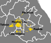
The extension of the Mexico City Metropolitan
area began in 1940 with the creation of the industrial zone of Naucalpan
. The increase of the metro area’s population, commerce and industry has continued to this day.The Consejo del Area Metropolitana was created in 1988 to coordinate concerns and action of the Greater Mexico City area in both the Distrito Federal and the State of Mexico.
From 1824 to 1941, the state had no seal. Governor Wenceslao Labra proposed one in 1940, which was adopted the following year. It was designed by Pastor Velázquez with the motto of “Patria, Libertad, Trabajo y Cultura” (Country, Liberty, Work and Culture).
In 1956, the Instituto Cientifico y Literario was converted into the Universidad Autónoma del Estado de México
.
During much of rest of the 20th century, works to divert water from the Lerma River
and other locations to Mexico City were built as well as highways through the state to connect Mexico City with the rest of the country.
In 1990, the Commission Coordinadora para la Recuperación Ecológica de la Cuenca del Alto Lerma (Coordinating Commission for the Ecological Recuperation of the Upper Lerma River Basin) was established.
, Hidalgo, Guerrero, Morelos, Puebla
, Tlaxcala
and Michoacán
. The state surrounds the Federal District of Mexico City on three sides (west, north and east).
The state is divided into five natural regions: the Volcanos of the Valley of Mexico, the hills and plains north of the state, the western mountains, the Balsas Depression and the mountains and valleys of the southeast.
The natural geography of the state varies. The eastern portion is dominated by the Sierra Nevada, which divides the state from Puebla. In this mountain chain are the Popocatépetl
and Iztaccíhuatl
volcanos. The Sierra de Monte Alto and Sierra de Monte Bajo divide the west side of the Federal District from the state and contain peaks such as Cerro de la Bufa and Monte de las Cruces. The Sierra de Xinantécatl is to the south of the Toluca Valley. At northern edge of this mountain range is the Nevado de Toluca
volcano. In the northwest of the state is the Sierra de San Andrés Timilpan. Most of the rock and soil formation in the state is of volcanic origin.
There are three river basins in the state: the Lerma, the Balsas
and the Pánuco
. The most important is the Lerma River, which begins in the municipality of Almoloya del Río
and passes through a large number of municipalities in the state. The southwestern part of the state is dominated by the Balsas River basin. The eastern panhandle of the state is dominated by the Pánuco River basin. On the various rivers of the state are dams such as José Antonio Alzate in Temoaya
, Ignacio Ramirez in Almoloya, Guadalupe in Cuautitlán Izcalli
, Madín in Naucalpan, Vicente Guerrero in Tlatlaya, Tepetitlan in San Felipe del Progreso
as well as those in Valle del Bravo and Villa Victoria
.
Lakes in the state include the Laguna del Sol and Laguna de la Luna in the Nevado de Toluca, the lake in the crater of the Cerro Gorde. Atexcapan Lake in Valle de Bravo, San Simón Lake in Donato Guerra, San Pedro Lake and Concepcion de los Baños Lake and Tepetitlan Lake in San Felipe del Progreso, Acuitzilapan Lake at the food of Jocotitlan Mountain, El Rodeo Lake near Xonacatlán
, Xibojay and Santa Elena Lakes in Jilotepec and Huapango Lake in Timilpan.
 About seventy percent of the state has a temperate moist climate, which consists of the highlands of the Toluca Valley and the areas around Texcoco in the north, the Toluca Valley and the areas around Texcoco. Average year-round temperature varies between 12C and 18C with annual precipitation above 700 millimeters. Higher elevations, about 13% of the state, in the center and east of the state have a semicold climate with average temperatures below 16C. Hotter climes are in the relative lowlands in the south west with have an average temperature of between 18C and 22C and constitute about eight percent of the territory. The hottest regions occupy five percent of the state in the extreme southwest with temperatures averaging over 22C. The coldest areas in the highest elevations such as the Nevado de Toluca, Popocatepetl and Iztaccihuatl. Snow can be found on these elevations year round. There are some arid areas along the borders of Hidalgo and Tlaxcala with annual precipitation between 500 and 700 milliliters.
Due to the various climates, the state has a wide variety of flora. 609,000 hectares is covered in tree, most of which is in the temperate and cold climates of the state. In the extreme southwest of the state, rainforests can be found and desert plants in the Hidalgo border area. In the highest altitudes, such as the peak of the Nevada de Toluca, alpine grassland can be found. In the extreme west, there are forests which receive thousands of monarch butterflies each winter.
The state has 49 environmentally protected areas, with the most important being the Nevado de Toluca National Park
. Other important areas include the state parks of Otomi-Mazahua, Sierra Morelos and Nahuatlaca-Matlatzinca. The Bonsencheve National Park extends into Mexico State from Michoacán, and is one of the major monarch butterfly sanctuaries. At the far east is the Iztaccihual-Popocatepetl National Park which is shared with neighboring Puebla state.
, Region VII Valle de Bravo and Region VIII Jilotepec. There are two metropolitan areas; the first is Greater Mexico City, in which are 27 municipalities and the six municipalities associated with the city of Toluca.
Five ethnicities are native to the state: the Mazahua, the Otomi, the Nahuas, the Matlazincas and the Ocuitecos or Tlahuicas. There are also communities of Mixtec
s, Zapotecs, Totonaca, Mazateca, Mixe
, P’urépecha and Maya
. According to the 2005 census, the state has 312,319 people who speak an indigenous language, which is about 3 out of every 100 people. Two thirds of those speaking an indigenous language also speak Spanish.
The state university is the Universidad Autónoma del Estado de Mexico which offers 48 majors. This and other institutes of higher education have an enrollment of over 100,000 students. The beginnings of this institution go back to 1828, when the first Instituto Literario for the state was established in what is now the borough of Tlalpan in Mexico City. It was reestablished in Toluca in 1833. In 1886, the name was changed to the Instituto Cientifico y Literario. In 1943, the institution gained autonomy from direct state control and in 1956, it was reorganized ias the UAEM. In 1964, the Ciudad Universitaria on the west side of Toluca was constructed.
Another important public university is the Universidad Autónoma de Chapingo
, located in Texcoco. It is an agricultural college offering technical and bachelor’s degrees. The school began as the Escuela Nacional de Agricultura (National School of Agriculture) which was founded in 1854 at the Monastery of San Jacinto in Mexico City. The school was moved in 1923 to the ex Hacienda of Chapingo President Álvaro Obregón
. One distinguishing feature of the campus is the mural done in the old chapel, now University Ceremonies Room by Diego Rivera
called “Tierra Fecundada” (Fertile Land). It is considered to be one of Rivera’s best works. More recently, the school acquired an unnamed mural by Luis Nishizawa
. This work depicts the agriculture of Mexico in both the past and the present. It is placed in a building that is commonly called “El Partenon”.
Other important educational institutions include the Universidad Technológica del Sur del Estado de Mexico http://www.utsem.edu.mx/utsem/ and a campus of the ITESM
http://tol.itesm.mx.
.
The Ferrocarriles Suburbanos is a commuter rail line that connects downtown Mexico City with northern Mexico State municipalities. Service began operations in 2008 with the Buenavista Lechería line. The Buenavista-Cuauhtitlan line was inaugurated in 2009, bringing the total rail ine to 27 km serving communities such as Tultitlán, San Rafael, Tlanepantla
and others.
The state contains 23 radio stations, 29 television station ( 2 local and 27 affiliates). The state sponsors two stations called “Radio Mexiquense” and “Televisión Mexiquense
”.
The next largest employer is commerce at 21.5%. One important segment of this sector is this hotel and restaurant industry. Outside of the metropolitan areas, tourism is an important element in the state economy, with attractions such as Valle de Bravo, Teotihuacan, Ixtapan de la Sal and others.
Most of the state’s land is devoted to agriculture (38.1%) or to forest (34.9%). Much of these crop forest lands are ejido or communal lands. The main crop is corn, with peas, barley, beans, potatoes, alfalfa, wheat, avocados and guava also grown. Livestock is raised on about 17% of the state’s farmland with cattle being the most important animal. Almost all of the forest lands in the state are used for producing forestry products such as wood and paper. However, this sector only employs 1.3% of the state’s population.
Other sectors of the economy include financial services, employing 21.4% of the population and transportation which employs 14.4%. While mining has been historically important, today it is only a minor activity despite residual deposits of gold, silver, lead and other minerals.
. The best known and most important of these is the massive Mesoamerican Teotihuacan, with thousands visiting it each year. This city predates the Aztecs and the Toltecs, and is distinguished by two large pyramids, the Pyramid of the Sun and the Pyramid of the Moon.
In Malinalco, the archeological site is officially called the Cuauhtinchan Archeological Zone but it is more commonly called the Cerro de los Idolos. The site is located on a cliff overlooking the town. The visible complex dates from the Aztec Empire but the site’s use as a ceremonial center appears to be much older. The main building served as a sanctuary for Aztec warriors. This complex has been compared to Ellora
in India
, Petra
on the shores of the Dead Sea
and Abu Simbel
in Egypt
.
Teotenango
was in important pre-Hispanic fortified city located in the southern part of the Valley of Toluca
. It was initially founded during the last stages of the Teotihuacan
civilization by a group generally referred to as the “Teotenancas.” Later, the Matlatzinca
s conquered the city and expanded it. The city existed for about 1,000 years, being abandoned only after the Spanish Conquest of the Aztec Empire. In the 15th century, it and the rest of the southern Toluca Valley was conquered by the Aztecs. In the 16th century, the Spanish took over, forced the residents to abandon the old city in favor on a new settlement on the valley floor.
Calixtlahuaca is another Matlazinca site located just outside of the city of Toluca. The site is at least 3,000 years old and shows Teotihuacan, Toltec
and Aztec influences. Located on the skirts of the Tenismó mountain, the most outstanding structure is the temple dedicated to Ehécatl
, or Quetzalcoatl
in his wind god aspect.
, Aculco
, Amanalco
, Amecameca, Ayapango
, El Oro, Ixtapan de la Sal
, Malinalco, Metepec, Otumba
, Temascalcingo
, San Juan Teotihuacán, Tlalmanalco
, Tonatico
and Villa del Carbón
. Other colonial structures can be found in Ozumba
, Toluca and the cities that surround Mexico City.
The state has twenty six museums and 543 libraries dependent on the Instituto Mexiquense de Cultura. Major institutions include the Centro Cultural Mexiquense
and the Notary Archive, the Executive and Legislative Archives in Toluca.
Valle de Bravo along with neighboring Lake Avandaro is a major weekend getaway for many in Mexico City and Mexico State. The town is filled with red tile roofs and stone paved streets and has been named a “Pueblo Magico” by the federal tourism agency. The lake is a result of the damming of a regional river and is home to more than forty nautical clubs.
The Grutas de la Estrella is located in the far south of the state on the border with Guerrero. It is a series of live caves in which running water creates formations, some of which are called “The Mammoth,” the “Bride and Groom,” “The Hand” and “The Palace.” They have lighting and other infrastructure as well as guided tours.
Most of the other natural attractions are situated on water sources.Ixtapan de la Sal and Tonatico are noted for their hot-water springs and water parks. Ixtapan de la Sal has attracted the construction of spas and water parks. Tonatico has the fifty-meter high El Salto Waterfall. The Lagunas de Zempoala (Zempoala Lakes) are located on the Santiago Tianguistenco
-Cuernavaca highway. The area has forest and cabins. The Isla de la Aves (Island of the Birds) is located in a lake in the municipalities of Atlacolmulco and Timilpan and has an aviary.
Zacango is the state’s major zoo with over 2,000 species from all over the world. It is located fourteen km from the city of Toluca in the municipality of Calimaya
. It is one of the few zoos in Mexico where all the animals live in natural-like enclosures.
The Cosmovitral
is a stained glass
mural and botanical garden located in Toluca. The building takes its name from the murals which are set in the buildings huge windows that surround the building and in the ceiling. The building originally was construction in 1910 as the 16 de Septiembre Market, but when this was closed in 1975, Leopoldo Flores
successfully convinced the city government to convert the building into a space for art. The Cosmovitral is located on the corner of Juárez and Lerdo de Tejada streets in the downtown. The best known aspect of t his work is the “Hombre Sol” or Sun Man. Each year on the spring equinox, the sun aligns with this panel of the stained glass work. This image has become one of the symbols of the state.
. Cooking utensils are made as well.
Objects made from precious metals such as silver are a specialty of the Mazahua people of the Toluca Valley. One specialty is jewelry and other decorative objects made with fine silver or gold wire. One community associated with this work is San Felipe del Progreso, where both wire and hammered items are made. Other communities of metalworkers exist in Naucalpan and Cuidad Nezahualcóyotl. In addition to jewelry, items such as bells, sculpture religious paraphernalia and more can be found.
Waxworks is dedicated mostly to the making of decorative and aromatic candles. These range from the simple to elaborately carved samples. These are mostluy made in Amecameca, Tenango del Valle and Toluca.
The making of piñata
s, decorative cut outs and other objects from paper and/or cardboard is known in Acolman, Metepec, Toluca, Huixquilucan, Nezahualcoyotl and Otumba. This tradition dates back to pre-Hispanic times with bark paper, but newer materials have been incorporated since then. For example, paper cut out banner or papel picado was originally done with crepe paper
(called “papel chino” in Spanish) but today it can be seen done on thin plastic sheets.
The making of fireworks is best known in Tultepec in the municipality of Lerma. Not only are firecrackers and rockets made, but elaborate contraptions with firecrackers place to moves the parts when lit are made as well. These can be called “castillos” (castles) or “toritos” (little bulls) depending on their shape. These are use during religious and secular festivals such as saints’ day and Independence Day. Tultepec holds a fireworks festival each year.
Other crafts practiced in the state include the making of candies, basketry, artistic ironwork, and items from bone, horn, stone and wood.
Traditional dances performed in the state include the Danza de los Concheros, Danza de Moros y Cristianos, Doce Pares de Francia, Morisma and Santiagos. One particular to Mexico State is the El Tzimare-cu, which is performed by the Otomi communities in Xonacatlán, Villa Cuauhtemoc and Temoaya.
The state is known for its red and black moles, the barbacoa
of Capulhuac
and Tenango del Valle, the chorizo
sausage of Toluca and the cheese products of Ayapango and Aculco. Beverages include pulque and “tecui.”
Major festivals and fairs in the state include the Feria de San Isidro Labrador, an agricultural fair in Metepec, the Festival de la Quimera, a cultural fair in Metepec, the Feria Internacional del Caballo horse fair in Texcoco, the Feria de la Nuez (Nut Fair) in Amecameca, the Festival de las Almas and Fiests de San Francisco de Asis in Valle de Bravo and the Feria de Alfeñique, which sells candies and other traditional goods for Day of the Dead
.
The Orquesta Sinfónica del Estado de México
or Mexico State Symphonic Orchestra was established in 1971 by Enrique Bátez Cambell. It is based in Toluca in the Felipe Villanueva Hall. It has given performances in various parts of both the state and nation of Mexico. It has made more recordings than any other state orchestra in the country, and in the 2000s it made its first appearances outside of Mexico in the United States and Europe.
Mexico City
Mexico City is the Federal District , capital of Mexico and seat of the federal powers of the Mexican Union. It is a federal entity within Mexico which is not part of any one of the 31 Mexican states but belongs to the federation as a whole...
, comprise the 32 Federal Entities of the United Mexican States. It is divided in 125 municipalities
Municipalities of Mexico State
The Mexican state of Mexico is made up of 125 municipios :-External links:* Estado de México / State of Mexico...
and its capital city is Toluca de Lerdo
Toluca
Toluca, formally known as Toluca de Lerdo, is the state capital of Mexico State as well as the seat of the Municipality of Toluca. It is the center of a rapidly growing urban area, now the fifth largest in Mexico. It is located west-southwest of Mexico City and only about 40 minutes by car to the...
.
The State of Mexico is often abbreviated to "Edomex" from Estado de México in Spanish). It is located in South-Central Mexico
South-Central Mexico
The South-Central Mexico is a region of the United Mexican States, formed by the states of Morelos and México; as well as Mexico City, federal district and capital of the country. It is located in the central plateau of Prehispanic Mexico in the area of Texcoco lake...
. It is bordered by the states of Querétaro
Querétaro
Querétaro officially Estado Libre y Soberano de Querétaro de Arteaga is one of the 31 states which, with the Federal District, comprise the 32 Federal Entities of Mexico. It is divided into 18 municipalities and its capital city is Santiago de Querétaro....
and Hidalgo to the north, Morelos
Morelos
Morelos officially Estado Libre y Soberano de Morelos is one of the 31 states which, with the Federal District, comprise the 32 Federal Entities of Mexico. It is divided in 33 municipalities and its capital city is Cuernavaca....
and Guerrero
Guerrero
Guerrero officially Estado Libre y Soberano de Guerrero is one of the 31 states which, with the Federal District, comprise the 32 Federal Entities of Mexico. It is divided in 81 municipalities and its capital city is Chilpancingo....
to the south, Michoacán
Michoacán
Michoacán officially Estado Libre y Soberano de Michoacán de Ocampo is one of the 31 states which, with the Federal District, comprise the 32 Federal Entities of Mexico. It is divided in 113 municipalities and its capital city is Morelia...
to the west, Tlaxcala
Tlaxcala
Tlaxcala officially Estado Libre y Soberano de Tlaxcala is one of the 31 states which along with the Federal District comprise the 32 federative entities of Mexico. It is divided into 60 municipalities and its capital city is Tlaxcala....
and Puebla
Puebla
Puebla officially Estado Libre y Soberano de Puebla is one of the 31 states which, with the Federal District, comprise the 32 Federal Entities of Mexico. It is divided in 217 municipalities and its capital city is Puebla....
to the east and surrounds the Federal District
Mexico City
Mexico City is the Federal District , capital of Mexico and seat of the federal powers of the Mexican Union. It is a federal entity within Mexico which is not part of any one of the 31 Mexican states but belongs to the federation as a whole...
.
The state’s origins are in the territory of the Aztec Empire, which remained a political division of New Spain
New Spain
New Spain, formally called the Viceroyalty of New Spain , was a viceroyalty of the Spanish colonial empire, comprising primarily territories in what was known then as 'América Septentrional' or North America. Its capital was Mexico City, formerly Tenochtitlan, capital of the Aztec Empire...
during the colonial period. After Independence
Mexican War of Independence
The Mexican War of Independence was an armed conflict between the people of Mexico and the Spanish colonial authorities which started on 16 September 1810. The movement, which became known as the Mexican War of Independence, was led by Mexican-born Spaniards, Mestizos and Amerindians who sought...
, Mexico City
Mexico City
Mexico City is the Federal District , capital of Mexico and seat of the federal powers of the Mexican Union. It is a federal entity within Mexico which is not part of any one of the 31 Mexican states but belongs to the federation as a whole...
was chosen as the capital of the new nation, its territory was separated out the state. Years later, parts of the state were broken off to form the states of Hidalgo, Guerrero and Morelos. These territorial separations have left the state with the size and shape it has today, with the Toluca Valley
Toluca Valley
Toluca Valley is a valley located approximately 75 km southwest Mexico City. The modern city of Toluca is located there. Other municipalities within valley and part of the Toluca metropolitan area include Metepec, Calimaya, Almoloya de Juárez, San Mateo Atenco, Lerma, Lago, Temoaya, Otzolotepec and...
to the west of Mexico City and a panhandle
Panhandle
A panhandle is an informal geographic term for an elongated arm-like protrusion of a geo-political entity, such as a subnational entity or a sovereign state.-Term:...
that extends around the north and east of this entity.
The name of the state is simply “México” according to the Political Constitution of the Mexican United States of 1917
Constitution of Mexico
The Political Constitution of the United Mexican States is the current constitution of Mexico. It was drafted in Santiago de Querétaro, in the State of Querétaro, by a constitutional convention, during the Mexican Revolution. It was approved by the Constitutional Congress on February 5, 1917...
, but to distinguish from both the city and the country it is most often called “Estado de México.”
Origin and etymology
Mēxihco was originally the NahuatlNahuatl
Nahuatl is thought to mean "a good, clear sound" This language name has several spellings, among them náhuatl , Naoatl, Nauatl, Nahuatl, Nawatl. In a back formation from the name of the language, the ethnic group of Nahuatl speakers are called Nahua...
name for the eponymous Valley of Mexico
Valley of Mexico
The Valley of Mexico is a highlands plateau in central Mexico roughly coterminous with the present-day Distrito Federal and the eastern half of the State of Mexico. Surrounded by mountains and volcanoes, the Valley of Mexico was a centre for several pre-Columbian civilizations, including...
wherein the cities of the Mexica
Mexica
The Mexica were a pre-Columbian people of central Mexico.Mexica may also refer to:*Mexica , a board game designed by Wolfgang Kramer and Michael Kiesling*Mexica , a 2005 novel by Norman Spinrad...
(the proper name for the Aztec Triple Alliance
Aztec Triple Alliance
The Aztec Triple Alliance, or Aztec Empire began as an alliance of three Nahua city-states or "altepeme": Tenochtitlan, Texcoco, and Tlacopan...
) were located. As such, the district that became Mexico City was properly known as Mexico-Tenochtitlan in the years shortly before and after Spanish conquest. After the Spanish Conquest, the term México came to be used for Tenochtitlan/Mexico City and all the pre-conquest lands it controlled, including several other aforementioned Mexican states
Territorial evolution of Mexico
Mexico has experienced many changes in territorial organization during its history as an independent state, especially as the territorial boundaries of Mexico were affected by presidential and imperial decrees...
originally incorporated in the boundaries of the México state.
There are two possible origins for the name “Mexico.” The first is that it derives from metztli (moon) and xictla (navel) to mean from the navel of the moon. This comes from the old Aztec
Aztec
The Aztec people were certain ethnic groups of central Mexico, particularly those groups who spoke the Nahuatl language and who dominated large parts of Mesoamerica in the 14th, 15th and 16th centuries, a period referred to as the late post-classic period in Mesoamerican chronology.Aztec is the...
idea that the craters on the moon form a rabbit figure with one crater imitating a navel. The other possible origin is that it is derived from “Mextictli” an alternate name for the god Huitzilopochtli
Huitzilopochtli
In Aztec mythology, Huitzilopochtli, also spelled Uitzilopochtli , was a god of war, a sun god, and the patron of the city of Tenochtitlan. He was also the national god of the Mexicas of Tenochtitlan.- Genealogy :...
.
Anáhuac
Anahuac
Anahuac is an ancient name for a Mesoamerican, particularly Aztec, area or areas, usually identified as located within or even coterminous with the Valley of Mexico...
was the proper term for all territories dominated by the Aztec Empire, from Cem Anáhuac, "the entire earth" or "surrounded by waters" e.g. the waters of Lake Texcoco
Lake Texcoco
Lake Texcoco was a natural lake formation within the Valley of Mexico. The Aztecs built the city of Tenochtitlan on an island in the lake. The Spaniards built Mexico City over Tenochtitlan...
which were considered to be the center of the Aztec world; and as such was proposed as an early name for the entire nation of Mexico
Mexico
The United Mexican States , commonly known as Mexico , is a federal constitutional republic in North America. It is bordered on the north by the United States; on the south and west by the Pacific Ocean; on the southeast by Guatemala, Belize, and the Caribbean Sea; and on the east by the Gulf of...
prior to independence, to distinguish it from the (preexisting) administrative division of New Spain
New Spain
New Spain, formally called the Viceroyalty of New Spain , was a viceroyalty of the Spanish colonial empire, comprising primarily territories in what was known then as 'América Septentrional' or North America. Its capital was Mexico City, formerly Tenochtitlan, capital of the Aztec Empire...
that became the State of Mexico.
Prehistoric to pre-Hispanic period
The earliest evidence of human habitation in current territory of the state is a quartzQuartz
Quartz is the second-most-abundant mineral in the Earth's continental crust, after feldspar. It is made up of a continuous framework of SiO4 silicon–oxygen tetrahedra, with each oxygen being shared between two tetrahedra, giving an overall formula SiO2. There are many different varieties of quartz,...
scraper and obsidian
Obsidian
Obsidian is a naturally occurring volcanic glass formed as an extrusive igneous rock.It is produced when felsic lava extruded from a volcano cools rapidly with minimum crystal growth...
blade found in the Tlapacoya area
Tlapacoya (Mesoamerican site)
Tlapacoya is an important archaeological site in Mexico, located at the foot of the Tlapacoya volcano, southeast of Mexico City, on the former shore of Lake Chalco. Tlapacoya was a major site for the Tlatilco culture....
, which was an island in the former Lake Chalco
Lake Chalco
Lake Chalco was an endorheic lake formerly located in the Valley of Mexico and was important for human development in central Mexico. The lake was named after the city of Chalco on its eastern shore....
. They are dated to the Pleistocene
Pleistocene
The Pleistocene is the epoch from 2,588,000 to 11,700 years BP that spans the world's recent period of repeated glaciations. The name pleistocene is derived from the Greek and ....
era which dates human habitation back to 20,000 years. These first peoples were hunter-gatherers. Stone age implements have been found all over the territory from mammoth bones, to stone tools to human remains. Most have been found in the areas of Los Reyes Acozac
Los Reyes Acozac
Los Reyes Acozac is a community that belongs to the municipality of Tecámac in the State of Mexico in Mexico. It has a population of 20,478 inhabitants and is located at an altitude of 2,250 meters above sea level. The area is known for significant deposits of mammoth bones.-References:...
, Tizayuca
Tizayuca
Tizayuca is a town and one of the 84 municipalities of Hidalgo, in central-eastern Mexico. The municipality covers an area of 92.5 km².As of 2005, the municipality had a total population of 56,573....
, Tepexpan
Tepexpan
Tepexpan is the largest town in the Acolman municipality in Mexico State, Mexico. The population was 48,103 as of the 2005 Mexican census.One of the most interesting aspects of this town is the discovery of an early Mesoamerican skeleton commonly referred to as "Tepexpan man". Recent research tries...
, San Francisco Mazapa, El Risco and Tequixquiac
Tequixquiac
Santiago Tequixquiac is the seat of the municipality of Tequixquiac located in the northeastern part of the state of Mexico in Mexico, although both are commonly called Tequixquiac. The town is located at a northern pass leading out of the Valley of Mexico and about 120 km northeast of the...
. Between 20,000 and 5000 BCE, the people here eventually went from hunting and gathering to sedimentary villages with farming and domesticated animals. The main crop was corn, and stone tools for the grinding of this grain become common. Later crops include beans, chili peppers and squash grown near established villages. Evidence of ceramics appears around 2500 BCE with the earliest artifacts of these appearing in Tlapacoya, Atoto
Atoto
Atoto is a village in Ancuabe District in Cabo Delgado Province in northeastern Mozambique.-External links:*...
, Malinalco
Malinalco
Malinalco is a town and municipality located 65 kilometers south of the city of Toluca in the south of the western portion of the Mexico State. Malinalco is 115 km southwest Mexico City....
, Acatzingo and Tlatilco
Tlatilco
Tlatilco was a large pre-Columbian village in the Valley of Mexico situated near the modern-day town of the same name in the Mexican Federal District. It was one of the first chiefdom centers to arise in the Valley, flourishing on the western shore of Lake Texcoco during the Middle Pre-Classic...
.
In prehistoric State of Mexico, the Tepexpan Man
Tepexpan man
The Tepexpan Man is a Pre-Columbian era skeleton, discovered by archaeologist Helmut de Terra in February 1947, on the shores of the former Lake Texcoco in central Mexico. The skeleton was found near mammoth remains and thought to be at least 10,000 years old. Dr. de Terra's research was funded by...
is an important finding for Mexcian and foreign anthropologists; it is an important key to understand what was the Valley of Mexico
Valley of Mexico
The Valley of Mexico is a highlands plateau in central Mexico roughly coterminous with the present-day Distrito Federal and the eastern half of the State of Mexico. Surrounded by mountains and volcanoes, the Valley of Mexico was a centre for several pre-Columbian civilizations, including...
area like, 5000 years ago, as well as helping establish the occupation chronology of the region. Currently some scholars attribute an age of 11 thousand years, others 8 thousand, and some have suggested 5 thousand years old. This individual, originally identified as a male, recent research confirm a female identity, although this is still subject of discussion.
Sacrum bone found in Tequixquiac is considered a work of prehistoric art. The town was inhabited in 35,000 BCE by primitive men who had crossed the Bering Strait
Bering Strait
The Bering Strait , known to natives as Imakpik, is a sea strait between Cape Dezhnev, Chukotka Autonomous Okrug, Russia, the easternmost point of the Asian continent and Cape Prince of Wales, Alaska, USA, the westernmost point of the North American continent, with latitude of about 65°40'N,...
from Asia. These people were nomadic, hunting large animals such as mammoths and gathering fruits as evidenced by archaeological evidence found at the site. One of the most salient discoveries of primitive art in America was found in here, called the Tequixquiac Bone, which had no known purpose, but reflected the ideological sense of the artist who carved the piece of bone from a camelid
Camelid
Camelids are members of the biological family Camelidae, the only living family in the suborder Tylopoda. Dromedaries, Bactrian Camels, llamas, alpacas, vicuñas, and guanacos are in this group....
around 22,000 years BCE. The first native settlers of Tequixquiac were the Aztecs and Otomi, who decided to settle here permanently for the abundance of rivers and springs. They were engaged mainly in agriculture and the breeding of domestic animals.
The earliest major civilization of the state is Teotihuacan
Teotihuacan
Teotihuacan – also written Teotihuacán, with a Spanish orthographic accent on the last syllable – is an enormous archaeological site in the Basin of Mexico, just 30 miles northeast of Mexico City, containing some of the largest pyramidal structures built in the pre-Columbian Americas...
, with the Pyramids of the Sun and Moon being built between 100 BCE and 100 CE. Between 800 and 900 CE, the Matlatzinca
Matlatzinca
Matlatzinca is a name used to refer to different indigenous ethnic groups in the Toluca Valley in the state of México, located in the central highlands of Mexico. The term is applied to the ethnic group inhabiting the valley of Toluca and to their language, Matlatzinca.When used as an ethnonym,...
s established their dominion with Teotenango
Teotenango
Teotenango was in important pre-Hispanic fortified city located in the southern part of the Valley of Toluca. It was initially founded during the last stages of the Teotihuacan civilization by a group generally referred to as the “Teotenancas.” Later, the Matlatzincas conquered the city and...
as capital. This city is walled with plazas, terraces, temples, altars, living quarters and a Mesoamerican ball game court.In the 15th century, the Aztecs conquered the Toluca and Chalco valleys to the west and east of the Valley of Mexico
Valley of Mexico
The Valley of Mexico is a highlands plateau in central Mexico roughly coterminous with the present-day Distrito Federal and the eastern half of the State of Mexico. Surrounded by mountains and volcanoes, the Valley of Mexico was a centre for several pre-Columbian civilizations, including...
respectively. Part of the Toluca Valley was held by the P’urhépechas
P'urhépecha
The P'urhépecha, normally spelled Purépecha in Spanish and in English and traditionally referred to as Tarascans, are an indigenous people centered in the northwestern region of the Mexican state of Michoacán, principally in the area of the cities of Uruapan and Pátzcuaro...
as well. Other dominions during the pre-Hispanic period include that of the Chichimeca
Chichimeca
Chichimeca was the name that the Nahua peoples of Mexico generically applied to a wide range of semi-nomadic peoples who inhabited the north of modern-day Mexico and southwestern United States, and carried the same sense as the European term "barbarian"...
s in Tenayuca
Tenayuca
Tenayuca is a pre-Columbian Mesoamerican archaeological site in the Valley of Mexico. In the Postclassic period of Mesoamerican chronology Tenayuca was a settlement on the former shoreline of the western arm of Lake Texcoco, located approximately 10km to the northwest of Tenochtitlan...
and of the Acolhua
Acolhua
The Acolhua are a Mesoamerican people who arrived in the Valley of Mexico in or around the year 1200 CE. The Acolhua were a sister culture of the Aztecs as well as the Tepanec, Chalca, Xochimilca and others....
s in Huexotla
Texcoco, Mexico State
Texcoco is a city and municipality located in the northeast portion of Mexico State, 25 km northeast of Mexico City. In the pre-Hispanic era, this was a major Aztec city on the shores of Lake Texcoco. After the Conquest, the city was initially the second most important after Mexico City,...
, Texcotizingo and Los Melones. Other important groups were the Mazahua
Mazahua
The Mazahua are an indigenous people of Mexico, inhabiting the northwestern portion of the State of Mexico and northeastern area of Michoacán, with a presence also in the Federal District owing to recent migration...
s in the Atlacomulco
Atlacomulco
Atlacomulco is a city and municipality located in the northwest of the State of Mexico in central Mexico, 63 km from the state capital of Toluca. The name is derived from the Nahuatl phrase "atlacomulli" which means "where there are wells." The city, with a population of 20,477 is...
area. Their center was at Mazahuacán, next to Jocotitlán
Jocotitlán
Jocotitlán is a town and municipality located in the northwestern part of the State of Mexico on the central highlands of the country of Mexico. The town is located at the foot of the Jocotitlán or Xocotépetl volcano, while most of the rest of the municipality is in the Ixtlahuaca Valley...
mountain. The Otomi
Otomi people
The Otomi people . Smaller Otomi populations exist in the states of Puebla, Mexico, Tlaxcala, Michoacán and Guanajuato. The Otomi language belonging to the Oto-Pamean branch of the Oto-Manguean language family is spoken in many different varieties some of which are not mutually intelligible.One of...
s were centered in Jilotepec.
Colonial period
The origin of the modern state is the reorganization of Aztec lands starting after the Spanish Conquest of the Aztec Empire. These lands were initially called the “audencia” of Mexico and included Mexico City, much of modern states of Guerrero, Morelos and Hidalgo. As the Spanish expanded their control west and south, the entirety was called “New Spain” with former Aztec lands being called “Mexico.” The organization of New Spain would change over the course of the colonial period, but the territory of the Aztecs would keep the name “Mexico”.After the Conquest in 1521, Hernán Cortés
Hernán Cortés
Hernán Cortés de Monroy y Pizarro, 1st Marquis of the Valley of Oaxaca was a Spanish Conquistador who led an expedition that caused the fall of the Aztec Empire and brought large portions of mainland Mexico under the rule of the King of Castile in the early 16th century...
’ cousin Juan Altamirano was given dominion of the Toluca Valley. Other conquistadors such as Antonio Caicedo, Juan de Jaramillo, Cristobal Hernandez and Juan de Samano received encomienda
Encomienda
The encomienda was a system that was employed mainly by the Spanish crown during the colonization of the Americas to regulate Native American labor....
s in the state. Franciscan
Franciscan
Most Franciscans are members of Roman Catholic religious orders founded by Saint Francis of Assisi. Besides Roman Catholic communities, there are also Old Catholic, Anglican, Lutheran, ecumenical and Non-denominational Franciscan communities....
missionaries came soon after such as Martin de Valencia, Juan de Tecto, Juan de Ahora, and Pedro de Gante, who established missions and the first school called San Antonio de Padua.
In 1535, the areas around Mexico City were divided into a number of “alcaldías mayors” called Chalco
Chalco
Aluminum Corporation of China Limited, also known as Chalco , is a multinational aluminum company headquartered in Beijing, People's Republic of China...
y Ameca
Amecameca
Amecameca is a town and municipality located in the eastern panhandle of Mexico State between Mexico City and the Iztaccíhuatl and Popocatépetl volcanos of the Sierra Nevada mountain range. It is located on federal highway 115 which leads to Cuautla, which is called the Volcano Route...
, Tlayacapan y Coatepec, Otumba
Otumba de Gómez Farías
Otumba or Otumba de Gómez Farías is a town and municipality located in the northeast of the State of Mexico, just northeast of Mexico City. Historically, this area is best known as the site of the Battle of Otumba and as an important crossroads during the colonial period where incoming viceroys...
, Ecatepec
Ecatepec de Morelos
Ecatepec City, once officially San Cristóbal Ecatepec de Morelos, is a city in the State of México and the seat of Ecatepec de Morelos Municipality; however, both the city and the municipality are often known simply as "Ecatepec". The name "Ecatepec" is derived from Nahuatl, and means "windy hill"....
, Sultepec
Sultepec
Sultepec is a town and municipality in Mexico State in Mexico. The municipality covers an area of 552.52 km².As of 2005, the municipality had a total population of 24,986.-References:...
, Zacualpan
Zacualpan, Mexico State
Zacualpan is a town and municipality in Mexico State in Mexico. The municipality covers an area of 301.47 km².As of 2005, the municipality had a total population of 13,800.-References:...
, Temascaltepec, Malinalco, Metepec
Metepec
Metepec is a city and municipality in the State of Mexico in Mexico and is located directly to the east of the state capital, Toluca, at an altitude of 2,635 metres above sea level. The centre of Mexico City lies some 50 km further to the east. The name Metepec comes from Náhuatl meaning hill of...
and Ixtlahuaca with Toluca and Texcoco
Texcoco, Mexico State
Texcoco is a city and municipality located in the northeast portion of Mexico State, 25 km northeast of Mexico City. In the pre-Hispanic era, this was a major Aztec city on the shores of Lake Texcoco. After the Conquest, the city was initially the second most important after Mexico City,...
recognized as cities. Other orders followed such as the Dominican
Dominican Order
The Order of Preachers , after the 15th century more commonly known as the Dominican Order or Dominicans, is a Catholic religious order founded by Saint Dominic and approved by Pope Honorius III on 22 December 1216 in France...
s, the Augustinians and the Jesuits.
During the colonial period, most of the area’s economy was based on agriculture with some mining in the areas of Temascaltepec, Sultepec, Valle de Bravo
Valle de Bravo
Valle de Bravo is a town and municipality located in Mexico State, Mexico. It is located on the shore of Lake Avándaro, approximately 156 km southwest of Mexico City and west of Toluca on highways 15, 134 or 1...
, Tlatlaya
Tlatlaya
Tlatlaya is a small town and municipality located in the southeast of the State of Mexico in Mexico. The word “Tlatlaya” means when the hearth is black and red.-The town:...
, Amatepec
Amatepec
Amatepec is a town and municipality, in Mexico State in Mexico. The municipality covers an area of 624.9 km².As of 2005, the municipality had a total population of 27,026....
and Zacualpan and the production of pulque
Pulque
Pulque, or octli, is a milk-colored, somewhat viscous alcoholic beverage made from the fermented sap of the maguey plant, and is a traditional native beverage of Mexico. The drink’s history extends far back into the Mesoamerican period, when it was considered sacred, and its use was limited to...
in Otumba and Texcoco. In addition certain areas were known for crafts such as wool processing in Texcoco and Sultepec, soap in Toluca, saddles in Almoloya de Juárez, and rebozo
Rebozo
A rebozo is a woman's garment used in Mexico. Rectangular in shape, rebozos vary in size from 1.5 to upwards of three metres, and can be made of cotton, wool, silk, or articela. They can be worn as scarves or shawls, and women often use them to carry children and take products to the market. It is...
s in various areas. However, the vast majority of the area’s population was extremely poor due to exploitation.
Independence
Michoacán
Michoacán officially Estado Libre y Soberano de Michoacán de Ocampo is one of the 31 states which, with the Federal District, comprise the 32 Federal Entities of Mexico. It is divided in 113 municipalities and its capital city is Morelia...
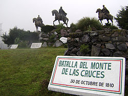
in 1810, passing from the northwest to Toluca on his way to Mexico City. East of Toluca, he fought royalist forces at the Battle of Monte de las Cruces
Battle of Monte de las Cruces
The Battle of Monte de las Cruces was one of the pivotal battles of the early Mexican War of Independence. It was fought between the insurgent troops of Miguel Hidalgo y Costilla and Ignacio Allende against the royalist troops of General Torcuato Trujillo in the Sierra de las Cruces mountains...
on 30 October 1810.. While Hidalgo won the battle, he chose not to proceed to Mexico City and then turned towards Celaya
Celaya
Celaya is a city and its surrounding municipality in the state of Guanajuato, Mexico, located in the southeast quadrant of the state. It is the third most populous city in the state, with a 2005 census population of 310,413. The municipality for which the city serves as municipal seat, had a...
. During the rest of the War, most battles were fought between local insurgent leaders such as Manuel de la Concha and Castillo Bustamante and royalist forces. Battles were fought in Sultepec
Sultepec
Sultepec is a town and municipality in Mexico State in Mexico. The municipality covers an area of 552.52 km².As of 2005, the municipality had a total population of 24,986.-References:...
, Amanalco
Amanalco
Amanalco is a town and municipality, in Mexico State in Mexico. The municipality covers an area of 219.49 km².As of 2005, the municipality had a total population of 20,343....
, Temascaltepec, Lerma
Lerma, Mexico State
Lerma is a city and municipality located just east of Toluca and 54 km west of Mexico City in Mexico State, Mexico. The city was founded in the early colonial period and named after the Duke of Lerma in Spain. The municipal area saw two battles of the Mexican War of Independence, the Battle...
, Tenango
Tenango del Valle
The municipality of Tenango del Valle and its seat, Tenango de Arista, are located in the southern portion of the Valley of Toluca in Mexico State, about 72 km southwest of Mexico City and 25 km south of Toluca. While the seat is officially named Tenango de Arista, it is more commonly...
, Tenancingo and Tecualoya.
After the War, the State of Mexico was created by the 1824 Constitution
1824 Constitution of Mexico
The Federal Constitution of the United Mexican States of 1824 was enacted on October 4 of 1824, after the overthrow of the Mexican Empire of Agustin de Iturbide. In the new constitution, the republic took the name of United Mexican States, and was defined as a representative federal republic, with...
, with the first state congress convening in March of that year in Mexico City. This state still encompassed the vast territory of the old Aztec Empire. The first head of the state was Melchor Múzquiz
Melchor Múzquiz
Melchor de Eca y Múzquiz was a Mexican soldier and politician. From August to December 1832 he was president of Mexico....
. The vast territory of the state was divided into eight districts:Acapulco
Acapulco
Acapulco is a city, municipality and major sea port in the state of Guerrero on the Pacific coast of Mexico, southwest from Mexico City. Acapulco is located on a deep, semi-circular bay and has been a port since the early colonial period of Mexico’s history...
, Cuernavaca
Cuernavaca
Cuernavaca is the capital and largest city of the state of Morelos in Mexico. It was established at the archeological site of Gualupita I by the Olmec, "the mother culture" of Mesoamerica, approximately 3200 years ago...
, Huejutla, México, Taxco
Taxco
Taxco de Alarcón is a small city and municipality located in the Mexican state of Guerrero. The name Taxco is most likely derived from the Nahuatl word tlacheco, which means “place of the ballgame.” However, one interpretation has the name coming from the word tatzco which means “where the father...
, Toluca, Tula
Tula, Hidalgo
Tula, formally, Tula de Allende, is a town and one of the 84 municipalities of Hidalgo, in central-eastern Mexico. The municipality covers an area of 305.8 km² , and as of 2005, the municipality had a total population of 93,296, with 28,432 in the town...
and Tulancingo
Tulancingo
Tulancingo is the second-largest city in the Mexican state of Hidalgo. It is located in the southeastern part of the state and also forms one of the 84 municipalities of Hidalgo, as well as the Archdiocese of Tulancingo...
. Mexico City was the capital of the state. However, soon after, the federal government choose Mexico City as the capital of the new nation. Under the guidelines of the 1824 Constitution, the capital was appropriated as federal land, with the federal government acting as the local authority. The choice was made official on 18 November 1824 and Congress delineated a surface area of two leagues square (8,800 ac) centered on the Zocalo
Zócalo
The Zócalo is the main plaza or square in the heart of the historic center of Mexico City. The plaza used to be known simply as the "Main Square" or "Arms Square," and today its formal name is Plaza de la Constitución...
. This area was then separated from the State of Mexico, forcing the state's government to move from the Palace of the Inquisition (now Museum of Mexican Medicine)
Palace of the Inquisition (Museum of Mexican Medicine)
The Palace of the Inquisition stands on the corner of Republica de Brasil and Republica de Venezuela streets in Mexico City, Mexico. While neither side of the building faces the Santo Domingo Plaza, the entrance does, as it is placed at the corner, which is canted to allow it to face in that...
in the city to Texcoco
Texcoco, Mexico State
Texcoco is a city and municipality located in the northeast portion of Mexico State, 25 km northeast of Mexico City. In the pre-Hispanic era, this was a major Aztec city on the shores of Lake Texcoco. After the Conquest, the city was initially the second most important after Mexico City,...
. This area did not yet include the population centers of the towns of Coyoacán
Coyoacán
Coyoacán refers to one of the sixteen boroughs of the Federal District of Mexico City as well as the former village which is now the borough’s “historic center.” The name comes from Nahuatl and most likely means “place of coyotes,” when the Aztecs named a pre-Hispanic village on the southern shore...
, Xochimilco
Xochimilco
Xochimilco is one of the sixteen delegaciones or boroughs within Mexican Federal District. The borough is centered on the formerly independent city of Xochimilco, which was established on what was the southern shore of Lake Xochimilco in the pre-Hispanic period...
, Mexicaltzingo
San Mateo Mexicaltzingo
San Mateo Mexicaltzingo is a town and the seat of the municipality of Mexicaltzingo located in the State of Mexico, in Mexico. It is located near Toluca...
and Tlalpan
Tlalpan
Tlalpan is one of the sixteen administrative boroughs of the Federal District of Mexico City. It is the largest borough, with over eighty percent under conservation as forest and other ecologically sensitive area. The rest, almost all of it on the northern edge, has been urban since the mid 20th...
, all of which remained as part of the State of Mexico. As the “federal district” of Mexico City grew in size, these and other territories were taken from the State of Mexico.
The capital of the state was moved permanently to Toluca in 1830.
The struggles between the liberals (federalists) and the conservatives (centralized power) in the 19th century affected the state, especially in those areas which would later break away to from the states of Hidalgo, Morelos and Guerrero. During the Mexican-American War, the Americans occupied Toluca and Mexico City with the state government temporarily located in the unoccupied Sultepec.
By 1852, the state had lost a significant amount of territory to the creation of the state of Guerrero, which promoted the reorganization of the municipalities here. During the Reform War
Reform War
The Reform War in Mexico is one of the episodes of the long struggle between Liberal and Conservative forces that dominated the country’s history in the 19th century. The Liberals wanted a federalist government, limiting traditional Catholic Church and military influence in the country...
, General José María Cobos took and sacked a number of municipalities in the territory remaining. During this war, a number of major figures such as Melchor Ocampo
Melchor Ocampo
Melchor Ocampo was a Mexican lawyer, scientist, and liberal politician.His home state was renamed Michoacán de Ocampo in his honour.-Studies:...
, Santos Delgollado and Leandro Valle were executed by firing squad in the Toluca Valley regions.
In 1869, the areas north east and south of Mexico City were converted to the states of Hidalgo and Morelos respectively. The state promulgated a new constitution in 1869, which established the state as consisting of the districts of Chalco, Cuautitlan, Ixtlahuaca, Jilotepec, Lerma, Otumba, Sultepec, Temascaltepec, Tenango del Valle, Tenancingo and Texcoco, which is the territory the state has today.
The period before the Mexican Revolution
Mexican Revolution
The Mexican Revolution was a major armed struggle that started in 1910, with an uprising led by Francisco I. Madero against longtime autocrat Porfirio Díaz. The Revolution was characterized by several socialist, liberal, anarchist, populist, and agrarianist movements. Over time the Revolution...
was relatively prosperous for the state, especially under governor José Vicente Villada, who promoted public education, government reform, the establishment of a teachers’ college for women and promoted the Instituto Cientifico y Literario (later UAEM). Mines in various parts of the state were at maximum production.
Mexican Revolution to present
Liberation Army of the South
The Liberation Army of the South was an armed group formed and led by Emiliano Zapata that took part in the Mexican Revolution. The force was commonly known as the Zapatistas....
in the southwest part of the state, with Genovevo de la O
Genovevo de la O
Genovevo de la O was an important figure in the Mexican Revolution.He was born in Santa María Ahuacatitlán, Morelos, to sharecropper parents. He was dedicated to the plight of Mexico's peasants and came to be an outstanding Liberation Army of the South guerrilla general...
and Francisco de Pacheco entering with their armies in 1912. Fighting intensified after Victoriano Huerta
Victoriano Huerta
José Victoriano Huerta Márquez was a Mexican military officer and president of Mexico. Huerta's supporters were known as Huertistas during the Mexican Revolution...
took power in 1913. In 1915, Toluca was the site of the Convencion de Generales y Gobernadores Revolucionaries (Convention of Generals and Revolutionary Governors) on two occasions. In 1917, the state had another new constitution, which divided the state into sixteen districts and 118 municipalities.
The extension of the Mexico City Metropolitan
Greater Mexico City
Greater Mexico City refers to the conurbation around Mexico City, officially called Mexico City Metropolitan Area , constituted by the Federal District—itself composed of 16 boroughs—and 41 adjacent municipalities of the states of Mexico and Hidalgo...
area began in 1940 with the creation of the industrial zone of Naucalpan
Naucalpan
Naucalpan, officially Naucalpan de Juárez, is a city and municipality located just northwest of Mexico City in adjoining Mexico State. The name Naucalpan comes from Nahuatl and means “place of the four neighborhoods or four houses. “de Juárez was added to the official name in 1874 in honor of...
. The increase of the metro area’s population, commerce and industry has continued to this day.The Consejo del Area Metropolitana was created in 1988 to coordinate concerns and action of the Greater Mexico City area in both the Distrito Federal and the State of Mexico.
From 1824 to 1941, the state had no seal. Governor Wenceslao Labra proposed one in 1940, which was adopted the following year. It was designed by Pastor Velázquez with the motto of “Patria, Libertad, Trabajo y Cultura” (Country, Liberty, Work and Culture).
In 1956, the Instituto Cientifico y Literario was converted into the Universidad Autónoma del Estado de México
Universidad Autónoma del Estado de México
The Universidad Autónoma del Estado de México is a public university in the State of Mexico, Mexico. It is the largest university institution in the state with over 84,500 students, with its central campus located in the state capital of Toluca...
.
During much of rest of the 20th century, works to divert water from the Lerma River
Lerma River
The Lerma Santiago River is Mexico's second longest river. It is a river in west-central Mexico that begins in Mexican Plateau at an altitude over above sea level, and ends where it empties into Lake Chapala, Mexico's largest lake, near Guadalajara, Jalisco...
and other locations to Mexico City were built as well as highways through the state to connect Mexico City with the rest of the country.
In 1990, the Commission Coordinadora para la Recuperación Ecológica de la Cuenca del Alto Lerma (Coordinating Commission for the Ecological Recuperation of the Upper Lerma River Basin) was established.
Geography, climate and nature
The state is located in the center of the country, consisting mostly of the eastern side of the Anahuác Mesa. Most of the state consists of the Toluca Valley, with the eastern panhandle mostly defined by the Chalco Valley. The state has a territory of 22,499.95km2 and borders the states of QuerétaroQuerétaro
Querétaro officially Estado Libre y Soberano de Querétaro de Arteaga is one of the 31 states which, with the Federal District, comprise the 32 Federal Entities of Mexico. It is divided into 18 municipalities and its capital city is Santiago de Querétaro....
, Hidalgo, Guerrero, Morelos, Puebla
Puebla
Puebla officially Estado Libre y Soberano de Puebla is one of the 31 states which, with the Federal District, comprise the 32 Federal Entities of Mexico. It is divided in 217 municipalities and its capital city is Puebla....
, Tlaxcala
Tlaxcala
Tlaxcala officially Estado Libre y Soberano de Tlaxcala is one of the 31 states which along with the Federal District comprise the 32 federative entities of Mexico. It is divided into 60 municipalities and its capital city is Tlaxcala....
and Michoacán
Michoacán
Michoacán officially Estado Libre y Soberano de Michoacán de Ocampo is one of the 31 states which, with the Federal District, comprise the 32 Federal Entities of Mexico. It is divided in 113 municipalities and its capital city is Morelia...
. The state surrounds the Federal District of Mexico City on three sides (west, north and east).
The state is divided into five natural regions: the Volcanos of the Valley of Mexico, the hills and plains north of the state, the western mountains, the Balsas Depression and the mountains and valleys of the southeast.
The natural geography of the state varies. The eastern portion is dominated by the Sierra Nevada, which divides the state from Puebla. In this mountain chain are the Popocatépetl
Popocatépetl
Popocatépetl also known as "Popochowa" by the local population is an active volcano and, at , the second highest peak in Mexico after the Pico de Orizaba...
and Iztaccíhuatl
Iztaccíhuatl
Iztaccíhuatl , is the third highest mountain in Mexico, after the Pico de Orizaba, , and Popocatépetl, . Its name is Nahuatl for "White woman"....
volcanos. The Sierra de Monte Alto and Sierra de Monte Bajo divide the west side of the Federal District from the state and contain peaks such as Cerro de la Bufa and Monte de las Cruces. The Sierra de Xinantécatl is to the south of the Toluca Valley. At northern edge of this mountain range is the Nevado de Toluca
Nevado de Toluca
Nevado de Toluca is a large stratovolcano in central Mexico, located about west of Mexico City near the city of Toluca. It is generally cited as the fourth highest of Mexico's peaks, after Pico de Orizaba, Popocatépetl and Iztaccíhuatl, although by some measurements, Sierra Negra is slightly...
volcano. In the northwest of the state is the Sierra de San Andrés Timilpan. Most of the rock and soil formation in the state is of volcanic origin.
There are three river basins in the state: the Lerma, the Balsas
Balsas River
The Balsas River is a major river of south-central Mexico. The basin flows through the states of Puebla, Morelos, Guerrero, and Mexico. The river empties into the Pacific Ocean at Mangrove Point, adjacent to the city of Lázaro Cárdenas, Michoacán...
and the Pánuco
Pánuco River
The Pánuco River is a river in Mexico that flows from the River Moctezuma in the Valley of Mexico to the Gulf of Mexico.At its source, it serves as a channel for water-drainage for Mexico City. From there, it becomes the state border between Hidalgo and Querétaro as it moves towards San Luis...
. The most important is the Lerma River, which begins in the municipality of Almoloya del Río
Almoloya del Río
Almolya del Río is a town and municipality located in the State of Mexico 26 km from the state capital of Toluca. It is located 2,600 meters above sea level. The name Almoloya comes from the Nahuatl phrase almoloyán which means place where water flows out...
and passes through a large number of municipalities in the state. The southwestern part of the state is dominated by the Balsas River basin. The eastern panhandle of the state is dominated by the Pánuco River basin. On the various rivers of the state are dams such as José Antonio Alzate in Temoaya
Temoaya
Temoaya is a town and municipality in Mexico State, Mexico, It is located from Toluca and from Mexico City. It is known for its large ethnic Otomi population, the Centro Ceremonial Otomí and its tradition of making Persian style rugs using Mexican designs....
, Ignacio Ramirez in Almoloya, Guadalupe in Cuautitlán Izcalli
Cuautitlán Izcalli
Cuautitlán Izcalli is a city and municipality in Mexico State, Mexico. The name comes from Náhuatl and means 'your house between the trees.' -City and municipal seat:...
, Madín in Naucalpan, Vicente Guerrero in Tlatlaya, Tepetitlan in San Felipe del Progreso
San Felipe del Progreso
San Felipe del Progreso is a town and municipality in the northwest of the State of Mexico. It is in the western part of ths state, 59 km from the state capital of Toluca and 72 km southwest of Atlacomulco. In colonial times, the village was founded as "San Felipe" or "San Felipe...
as well as those in Valle del Bravo and Villa Victoria
Villa Victoria
Villa Victoria is a town and municipality in Mexico State in Mexico. The municipality covers an area of 424.03 km².As of 2005, the municipality had a total population of 77,819....
.
Lakes in the state include the Laguna del Sol and Laguna de la Luna in the Nevado de Toluca, the lake in the crater of the Cerro Gorde. Atexcapan Lake in Valle de Bravo, San Simón Lake in Donato Guerra, San Pedro Lake and Concepcion de los Baños Lake and Tepetitlan Lake in San Felipe del Progreso, Acuitzilapan Lake at the food of Jocotitlan Mountain, El Rodeo Lake near Xonacatlán
Xonacatlán
Xonacatlán is a town and municipality in Mexico State in Mexico. The municipality covers an area of 32.87 km².As of 2005, the municipality had a total population of 45,274.-Etymology:...
, Xibojay and Santa Elena Lakes in Jilotepec and Huapango Lake in Timilpan.
Due to the various climates, the state has a wide variety of flora. 609,000 hectares is covered in tree, most of which is in the temperate and cold climates of the state. In the extreme southwest of the state, rainforests can be found and desert plants in the Hidalgo border area. In the highest altitudes, such as the peak of the Nevada de Toluca, alpine grassland can be found. In the extreme west, there are forests which receive thousands of monarch butterflies each winter.
The state has 49 environmentally protected areas, with the most important being the Nevado de Toluca National Park
Nevado de Toluca National Park
The Nevado de Toluca National Park is located southwest of the city of Toluca, Mexico State. It was decreed a park in 1936, primarily to protect the Nevado de Toluca volcano, which forms nearly the park’s entire surface and is the fourth highest peak in Mexico. It is 45 km from Toluca and 135...
. Other important areas include the state parks of Otomi-Mazahua, Sierra Morelos and Nahuatlaca-Matlatzinca. The Bonsencheve National Park extends into Mexico State from Michoacán, and is one of the major monarch butterfly sanctuaries. At the far east is the Iztaccihual-Popocatepetl National Park which is shared with neighboring Puebla state.
Politics
The state is divided into 125 municipalities, which are group into seven regions: Region I Toluca, Region II Zumpango, Region IIITexcoco, Region IV Tejupilco, Region V Atlacomulco, Region VI Coatepec HarinasCoatepec Harinas
Coatepec Harinas is a town and municipality in Mexico State, Mexico. The original name is "Coauhtepetl" which means 'serpent hill' in Náhuatl. Around 1825 because of a boom in flour production, the name "Harinas" was added.-The town:...
, Region VII Valle de Bravo and Region VIII Jilotepec. There are two metropolitan areas; the first is Greater Mexico City, in which are 27 municipalities and the six municipalities associated with the city of Toluca.
Demographics
The state contains about thirteen percent of the country’s population and is one of the most densely populated with 520 people per square km. Most of the population growth has come from the expansion of Greater Mexico City outside the borders of the Federal District and into the state, especially since 1970. 85% of the population lives in urban centers, and 39% were born in other parts of Mexico.Five ethnicities are native to the state: the Mazahua, the Otomi, the Nahuas, the Matlazincas and the Ocuitecos or Tlahuicas. There are also communities of Mixtec
Mixtec
The Mixtec are indigenous Mesoamerican peoples inhabiting the Mexican states of Oaxaca, Guerrero and Puebla in a region known as La Mixteca. The Mixtecan languages form an important branch of the Otomanguean language family....
s, Zapotecs, Totonaca, Mazateca, Mixe
Mixe
The Mixe or Mije is an indigenous group inhabiting the eastern highlands of the Mexican state of Oaxaca. They speak the Mixe languages which are classified in the Mixe–Zoque family, and are more culturally conservative than other indigenous groups of the region, maintaining their language to this...
, P’urépecha and Maya
Maya peoples
The Maya people constitute a diverse range of the Native American people of southern Mexico and northern Central America. The overarching term "Maya" is a collective designation to include the peoples of the region who share some degree of cultural and linguistic heritage; however, the term...
. According to the 2005 census, the state has 312,319 people who speak an indigenous language, which is about 3 out of every 100 people. Two thirds of those speaking an indigenous language also speak Spanish.
Education
The state has over three million students who attend about 15,000 schools from kindergarten to high school. It is the largest school system in the country after that of Mexico City. However, as late as 1990, here were over half a million people who were illiterate over the age of 15.The state university is the Universidad Autónoma del Estado de Mexico which offers 48 majors. This and other institutes of higher education have an enrollment of over 100,000 students. The beginnings of this institution go back to 1828, when the first Instituto Literario for the state was established in what is now the borough of Tlalpan in Mexico City. It was reestablished in Toluca in 1833. In 1886, the name was changed to the Instituto Cientifico y Literario. In 1943, the institution gained autonomy from direct state control and in 1956, it was reorganized ias the UAEM. In 1964, the Ciudad Universitaria on the west side of Toluca was constructed.
Another important public university is the Universidad Autónoma de Chapingo
Chapingo Autonomous University
Universidad Autónoma Chapingo is an agricultural college located in Texcoco, Mexico State in Mexico. The university is a federally funded public institution of higher education. It offers technical and full bachelor’s degrees as well as having scientific and technological research programs...
, located in Texcoco. It is an agricultural college offering technical and bachelor’s degrees. The school began as the Escuela Nacional de Agricultura (National School of Agriculture) which was founded in 1854 at the Monastery of San Jacinto in Mexico City. The school was moved in 1923 to the ex Hacienda of Chapingo President Álvaro Obregón
Álvaro Obregón
General Álvaro Obregón Salido was the President of Mexico from 1920 to 1924. He was assassinated in 1928, shortly after winning election to another presidential term....
. One distinguishing feature of the campus is the mural done in the old chapel, now University Ceremonies Room by Diego Rivera
Diego Rivera
Diego María de la Concepción Juan Nepomuceno Estanislao de la Rivera y Barrientos Acosta y Rodríguez was a prominent Mexican painter born in Guanajuato, Guanajuato, an active communist, and husband of Frida Kahlo . His large wall works in fresco helped establish the Mexican Mural Movement in...
called “Tierra Fecundada” (Fertile Land). It is considered to be one of Rivera’s best works. More recently, the school acquired an unnamed mural by Luis Nishizawa
Luis Nishizawa
Luis Nishizawa Flores is a Mexican artist. His father, Kenji Nishizawa is Japanese with origins from Nagano prefecture and his mother, María de Jesús Flores is Mexican....
. This work depicts the agriculture of Mexico in both the past and the present. It is placed in a building that is commonly called “El Partenon”.
Other important educational institutions include the Universidad Technológica del Sur del Estado de Mexico http://www.utsem.edu.mx/utsem/ and a campus of the ITESM
Monterrey Institute of Technology and Higher Education, Toluca
The Monterrey Institute of Technology and Higher Education, Toluca Campus commonly shortened as Tecnológico de Monterrey, Campus Toluca or ITESM Campus Toluca, is a campus of the Monterrey Institute of Technology and Higher Education private university system located on the west side of...
http://tol.itesm.mx.
Infrastructure
The state contains 9,723 km of highways with about 90% being state and 10% federal. There are 1227.4 km of rail line and two airports, “Lic. Adolfo López Mateos” in Toluca and “Dr. Jorge Jiménez Cantú” in Atizapán de Zaragoza. Helicopter facilities exist in Chimalhuacán and JocotitlánJocotitlán
Jocotitlán is a town and municipality located in the northwestern part of the State of Mexico on the central highlands of the country of Mexico. The town is located at the foot of the Jocotitlán or Xocotépetl volcano, while most of the rest of the municipality is in the Ixtlahuaca Valley...
.
The Ferrocarriles Suburbanos is a commuter rail line that connects downtown Mexico City with northern Mexico State municipalities. Service began operations in 2008 with the Buenavista Lechería line. The Buenavista-Cuauhtitlan line was inaugurated in 2009, bringing the total rail ine to 27 km serving communities such as Tultitlán, San Rafael, Tlanepantla
Tlalnepantla de Baz
Tlalnepantla de Baz is a city and a municipality of the State of Mexico in the north of Mexico City . Tlalnepantla comes from the Náhuatl words tlalli and nepantla to mean the middle land...
and others.
The state contains 23 radio stations, 29 television station ( 2 local and 27 affiliates). The state sponsors two stations called “Radio Mexiquense” and “Televisión Mexiquense
Televisión Mexiquense
Televisión Mexiquense, also known as Canal 34, is a public television network for the Mexican state of México. The network's main station, XHPTP-TV channel 34 and channel 41 , originates from Tres Padres Peak in the municipality of Coacalco de Berriozabal, México...
”.
Economy
The state provides 9.7% of the country’s gross national product, with over 12% of all of Mexico’s active workforce employed in the state. The most important sector of the economy is industry and manufacturing, with over 10% of the state’s land urbanized. The State of Mexico ranks second in the country for industrial output. The most important industries include chemicals, food products, textiles, paper products, metalworks and the construction and maintenance of transport vehicles. This sector employs the highest percentage of the population at 27.7%.The next largest employer is commerce at 21.5%. One important segment of this sector is this hotel and restaurant industry. Outside of the metropolitan areas, tourism is an important element in the state economy, with attractions such as Valle de Bravo, Teotihuacan, Ixtapan de la Sal and others.
Most of the state’s land is devoted to agriculture (38.1%) or to forest (34.9%). Much of these crop forest lands are ejido or communal lands. The main crop is corn, with peas, barley, beans, potatoes, alfalfa, wheat, avocados and guava also grown. Livestock is raised on about 17% of the state’s farmland with cattle being the most important animal. Almost all of the forest lands in the state are used for producing forestry products such as wood and paper. However, this sector only employs 1.3% of the state’s population.
Other sectors of the economy include financial services, employing 21.4% of the population and transportation which employs 14.4%. While mining has been historically important, today it is only a minor activity despite residual deposits of gold, silver, lead and other minerals.
Archeological sites
Main archeological sites include Teotihuacan, Malinalco, Teotenango and CalixtlahuacaCalixtlahuaca
Calixtlahuaca is a Postclassic period Mesoamerican archaeological site, located near the present-day city of Toluca in the State of Mexico...
. The best known and most important of these is the massive Mesoamerican Teotihuacan, with thousands visiting it each year. This city predates the Aztecs and the Toltecs, and is distinguished by two large pyramids, the Pyramid of the Sun and the Pyramid of the Moon.
In Malinalco, the archeological site is officially called the Cuauhtinchan Archeological Zone but it is more commonly called the Cerro de los Idolos. The site is located on a cliff overlooking the town. The visible complex dates from the Aztec Empire but the site’s use as a ceremonial center appears to be much older. The main building served as a sanctuary for Aztec warriors. This complex has been compared to Ellora
Ellora Caves
Ellora is an archaeological site, from the city of Aurangabad in the Indian state of Maharashtra built by the Rashtrakuta dynasty . Well-known for its monumental caves, Ellora is a World Heritage Site. Ellora represents the epitome of Indian rock-cut architecture. The 34 "caves" – actually...
in India
India
India , officially the Republic of India , is a country in South Asia. It is the seventh-largest country by geographical area, the second-most populous country with over 1.2 billion people, and the most populous democracy in the world...
, Petra
Petra
Petra is a historical and archaeological city in the Jordanian governorate of Ma'an that is famous for its rock cut architecture and water conduits system. Established sometime around the 6th century BC as the capital city of the Nabataeans, it is a symbol of Jordan as well as its most visited...
on the shores of the Dead Sea
Dead Sea
The Dead Sea , also called the Salt Sea, is a salt lake bordering Jordan to the east and Israel and the West Bank to the west. Its surface and shores are below sea level, the lowest elevation on the Earth's surface. The Dead Sea is deep, the deepest hypersaline lake in the world...
and Abu Simbel
Abu Simbel
Abu Simbel temples refers to two massive rock temples in Abu Simbel in Nubia, southern Egypt on the western bank of Lake Nasser about 230 km southwest of Aswan...
in Egypt
Egypt
Egypt , officially the Arab Republic of Egypt, Arabic: , is a country mainly in North Africa, with the Sinai Peninsula forming a land bridge in Southwest Asia. Egypt is thus a transcontinental country, and a major power in Africa, the Mediterranean Basin, the Middle East and the Muslim world...
.
Teotenango
Teotenango
Teotenango was in important pre-Hispanic fortified city located in the southern part of the Valley of Toluca. It was initially founded during the last stages of the Teotihuacan civilization by a group generally referred to as the “Teotenancas.” Later, the Matlatzincas conquered the city and...
was in important pre-Hispanic fortified city located in the southern part of the Valley of Toluca
Toluca Valley
Toluca Valley is a valley located approximately 75 km southwest Mexico City. The modern city of Toluca is located there. Other municipalities within valley and part of the Toluca metropolitan area include Metepec, Calimaya, Almoloya de Juárez, San Mateo Atenco, Lerma, Lago, Temoaya, Otzolotepec and...
. It was initially founded during the last stages of the Teotihuacan
Teotihuacan
Teotihuacan – also written Teotihuacán, with a Spanish orthographic accent on the last syllable – is an enormous archaeological site in the Basin of Mexico, just 30 miles northeast of Mexico City, containing some of the largest pyramidal structures built in the pre-Columbian Americas...
civilization by a group generally referred to as the “Teotenancas.” Later, the Matlatzinca
Matlatzinca
Matlatzinca is a name used to refer to different indigenous ethnic groups in the Toluca Valley in the state of México, located in the central highlands of Mexico. The term is applied to the ethnic group inhabiting the valley of Toluca and to their language, Matlatzinca.When used as an ethnonym,...
s conquered the city and expanded it. The city existed for about 1,000 years, being abandoned only after the Spanish Conquest of the Aztec Empire. In the 15th century, it and the rest of the southern Toluca Valley was conquered by the Aztecs. In the 16th century, the Spanish took over, forced the residents to abandon the old city in favor on a new settlement on the valley floor.
Calixtlahuaca is another Matlazinca site located just outside of the city of Toluca. The site is at least 3,000 years old and shows Teotihuacan, Toltec
Toltec
The Toltec culture is an archaeological Mesoamerican culture that dominated a state centered in Tula, Hidalgo in the early post-classic period of Mesoamerican chronology...
and Aztec influences. Located on the skirts of the Tenismó mountain, the most outstanding structure is the temple dedicated to Ehécatl
Ehecatl
Ehecatl is a pre-Columbian deity associated with the wind, who features in Aztec mythology and the mythologies of other cultures from the central Mexico region of Mesoamerica. He is most usually interpreted as the aspect of the Feathered Serpent deity as a god of wind, and is therefore also known...
, or Quetzalcoatl
Quetzalcoatl
Quetzalcoatl is a Mesoamerican deity whose name comes from the Nahuatl language and has the meaning of "feathered serpent". The worship of a feathered serpent deity is first documented in Teotihuacan in the first century BCE or first century CE...
in his wind god aspect.
Colonial and other historical sites
Most of the state’s colonial attractions are promoted through the “Pueblos con Encanto” program. These include the monasteries and churches located in towns such as de AcolmanAcolman
Acolman de Nezahualcoyotl is a town and municipality located in the northern part of Mexico State, part of the Greater Mexico City area, just north of the city proper. According to myth, the first man was placed here after being taken out of Lake Texcoco. In the community of Tepexpan, the...
, Aculco
Aculco
Aculco de Espinoza is a town and the seat of the municipality called Aculco in Mexico State.-History:Aculco was founded approximately in 1110 A.D. by the Otomies, despite the fact that its name comes from Nahuatl...
, Amanalco
Amanalco
Amanalco is a town and municipality, in Mexico State in Mexico. The municipality covers an area of 219.49 km².As of 2005, the municipality had a total population of 20,343....
, Amecameca, Ayapango
Ayapango
Ayapango is a small town and municipality located in the southeast portion of the State of Mexico, southeast of Mexico City. Despite the fact that this municipality is distinctly rural, it falls within the Mexico City Metropolitan Area...
, El Oro, Ixtapan de la Sal
Ixtapan de la Sal
Ixtapan de la Sal is a town and municipality located in the State of Mexico, Mexico. It is 60 km south of Toluca, the state capital. The word Ixtapan comes from Nahuatl. There are two theories as to the origin of the name. The first one states that it is composed of iztal, which means salt,...
, Malinalco, Metepec, Otumba
Otumba
Otumba may refer to:*Otumba, Mexico State, a municipality in the State of Mexico, Mexico*Otumba de Gómez Farías, a town and the municipal seat of Otumba municipality, State of Mexico*Otompan, a pre-Columbian altepetl...
, Temascalcingo
Temascalcingo
Temascalcingo de José Maria Velasco is a town and seat of the municipality of Temascalcingo in the State of Mexico, Mexico. It is located in the northeast of the state. The temazcal was very common in Temascalcingo. The name Temascalcingo has its roots in Nahuatl. It means place of the little...
, San Juan Teotihuacán, Tlalmanalco
Tlalmanalco
Tlalmanalco is a town and municipality located in the far south-eastern part of the State of Mexico. The name is from the Nahuatl language, meaning “flat area.” The municipality’s seal shows flat land, with a pyramid on it, representing its pre-Hispanic history, surrounded by small mountains, which...
, Tonatico
Tonatico
Tonatico is a town and municipality of State of Mexico, in Mexico located 153 kilometers from Mexico City, 105 from Cuernavaca, 84 from Toluca, 68 from Taxco and 5 from Ixtapan de la Sal. Tonatico, of Náhuatl origin, is from the Náhuatl word tonatihco, place of the sun.-The town:In the area around...
and Villa del Carbón
Villa del Carbón
Villa del Carbón is a town and municipality located in the northern part of Mexico State, just northwest of Mexico City. While the town of Villa del Carbón is the largest in the municipality, it is not the oldest. The municipality contains a number of villages of Otomí and Nahua origins, in which...
. Other colonial structures can be found in Ozumba
Ozumba
Ozumba is a town and municipality located in the southeast portion of the Valley of Mexico, 70km southeast of Mexico City near the Mexico City-Cuautla highway. The main feature of this area is the Parish of the Immaculate Conception which began as a Franciscan monastery in the 16th century...
, Toluca and the cities that surround Mexico City.
The state has twenty six museums and 543 libraries dependent on the Instituto Mexiquense de Cultura. Major institutions include the Centro Cultural Mexiquense
Centro Cultural Mexiquense
Centro Cultural Mexiquense is a cultural center located on the western edge of the city of Toluca in central Mexico. The center is run by the State of Mexico government through an agency called the Instituto Mexiquense de Cultura , the largest and most important of this agency, receiving about...
and the Notary Archive, the Executive and Legislative Archives in Toluca.
Natural attractions
The natural feature most closely associated with the state is the Nevado de Toluca or Xinantécatl volcano which is just south of the capital of Toluca. This is an extinct volcano which rises 4,690 masl, making it the fourth highest peak in Mexico. At the top is a very large crater that contains two lakes called the Laguna del Sol and the Laguna de la Luna. The volcano and its immediate surroundings are part of the Nevado de Toluca National Park and the Los Venado National Park.Valle de Bravo along with neighboring Lake Avandaro is a major weekend getaway for many in Mexico City and Mexico State. The town is filled with red tile roofs and stone paved streets and has been named a “Pueblo Magico” by the federal tourism agency. The lake is a result of the damming of a regional river and is home to more than forty nautical clubs.
The Grutas de la Estrella is located in the far south of the state on the border with Guerrero. It is a series of live caves in which running water creates formations, some of which are called “The Mammoth,” the “Bride and Groom,” “The Hand” and “The Palace.” They have lighting and other infrastructure as well as guided tours.
Most of the other natural attractions are situated on water sources.Ixtapan de la Sal and Tonatico are noted for their hot-water springs and water parks. Ixtapan de la Sal has attracted the construction of spas and water parks. Tonatico has the fifty-meter high El Salto Waterfall. The Lagunas de Zempoala (Zempoala Lakes) are located on the Santiago Tianguistenco
Santiago Tianguistenco
Santiago Tianguistenco, often just simply called Tianguistenco, is a city and municipality located in Mexico State about thirty km south of the state capital of Toluca. It is located in the southwest part of the Valley of Toluca at the edge of the Ajusco mountain range that separates it from Mexico...
-Cuernavaca highway. The area has forest and cabins. The Isla de la Aves (Island of the Birds) is located in a lake in the municipalities of Atlacolmulco and Timilpan and has an aviary.
Others
To honor the native peoples of the area, there are the Centro Ceremonial Otomi in Temoaya and the Centro Ceremonial Mazahua in San Felipe del Progreso. Both of these have museums, auditoriums, handcrafts centers as well as large forested areas for camping and hiking. Both were built to honor and preserve these indigenous cultures.Zacango is the state’s major zoo with over 2,000 species from all over the world. It is located fourteen km from the city of Toluca in the municipality of Calimaya
Calimaya
Calimaya is a town and municipality located just south of Toluca, the capital of the State of Mexico in central Mexico. The settlement was probably established around 800 BCE, when the city of Teotenango was in existence. It remained an important town through the colonial period, part of the vast...
. It is one of the few zoos in Mexico where all the animals live in natural-like enclosures.
The Cosmovitral
Cosmovitral
The Cosmovitral is a stained glass mural and botanical garden located in Toluca, Mexico. The building takes its name from the mural which is set in the buildings huge windows that surround the building and in the ceiling...
is a stained glass
Stained glass
The term stained glass can refer to coloured glass as a material or to works produced from it. Throughout its thousand-year history, the term has been applied almost exclusively to the windows of churches and other significant buildings...
mural and botanical garden located in Toluca. The building takes its name from the murals which are set in the buildings huge windows that surround the building and in the ceiling. The building originally was construction in 1910 as the 16 de Septiembre Market, but when this was closed in 1975, Leopoldo Flores
Leopoldo Flores
Leopoldo Flores was born in Tenancingo, Estado de México in 1934. He is a muralist, sculptor, intellectual.Flores had his start in the Mural-Pancarta Movement. He was consistent in installing monumental artistic paintings on buildings. With a singular creativity in Aratmosfera painting, consisting...
successfully convinced the city government to convert the building into a space for art. The Cosmovitral is located on the corner of Juárez and Lerdo de Tejada streets in the downtown. The best known aspect of t his work is the “Hombre Sol” or Sun Man. Each year on the spring equinox, the sun aligns with this panel of the stained glass work. This image has become one of the symbols of the state.
Culture
Ceramics have been made in the Toluca Valley region since far into the pre-Hispanic period, mostly by Matlatzincas and Nahuas. The tradition continued into the colonial period although it much changed in both technique and design. Today both manufactured and handcrafted ceramics are produced in the state. The most traditional handcrafted wares are produced in places such as Metepec, Valle de Bravo, Texcoco and Almoloya de Juárez among others. The best known pottery and ceramics locale is Metepec, which specializes in large decorative pieces and sculptures called Trees of LifeTree of Life (craft)
A Tree of Life is a theme of clay sculpture created in central Mexico, especially in the municipality of Metepec, Mexico State. The image depicted in these sculptures originally was for the teaching of the Biblical story of creation to natives in the early colonial period...
. Cooking utensils are made as well.
Objects made from precious metals such as silver are a specialty of the Mazahua people of the Toluca Valley. One specialty is jewelry and other decorative objects made with fine silver or gold wire. One community associated with this work is San Felipe del Progreso, where both wire and hammered items are made. Other communities of metalworkers exist in Naucalpan and Cuidad Nezahualcóyotl. In addition to jewelry, items such as bells, sculpture religious paraphernalia and more can be found.
Waxworks is dedicated mostly to the making of decorative and aromatic candles. These range from the simple to elaborately carved samples. These are mostluy made in Amecameca, Tenango del Valle and Toluca.
The making of piñata
Piñata
A piñata is a papier-mâché or other type of container that is decorated, filled with toys and or candy and then broken as part of a ceremony or celebration. Piñatas are most commonly associated with Mexico, but its origins are considered to be in China...
s, decorative cut outs and other objects from paper and/or cardboard is known in Acolman, Metepec, Toluca, Huixquilucan, Nezahualcoyotl and Otumba. This tradition dates back to pre-Hispanic times with bark paper, but newer materials have been incorporated since then. For example, paper cut out banner or papel picado was originally done with crepe paper
Crêpe paper
Crêpe paper is tissue paper that has been coated with sizing and then creped to create gathers.-Production:Paper that is creped is produced on a paper machine that has a single large steam-heated drying cylinder fitted with a hot-air hood. The raw material is paper pulp. The Yankee cylinder is...
(called “papel chino” in Spanish) but today it can be seen done on thin plastic sheets.
The making of fireworks is best known in Tultepec in the municipality of Lerma. Not only are firecrackers and rockets made, but elaborate contraptions with firecrackers place to moves the parts when lit are made as well. These can be called “castillos” (castles) or “toritos” (little bulls) depending on their shape. These are use during religious and secular festivals such as saints’ day and Independence Day. Tultepec holds a fireworks festival each year.
Other crafts practiced in the state include the making of candies, basketry, artistic ironwork, and items from bone, horn, stone and wood.
Traditional dances performed in the state include the Danza de los Concheros, Danza de Moros y Cristianos, Doce Pares de Francia, Morisma and Santiagos. One particular to Mexico State is the El Tzimare-cu, which is performed by the Otomi communities in Xonacatlán, Villa Cuauhtemoc and Temoaya.
The state is known for its red and black moles, the barbacoa
Barbacoa
Barbacoa is a form of cooking meat that originated in the Caribbean with the Taíno people, from which the term "barbecue" derives. In contemporary Mexico it generally refers to meats or a whole sheep slow-cooked over an open fire, or more traditionally, in a hole dug in the ground covered with...
of Capulhuac
Capulhuac
Capulhuac is a small town and municipality, in Mexico State in Mexico. The municipality covers an area of 21.5 km².As of 2005, the municipality had a total population of 30,838.Prominent PeopleJosue Mirlo Salvador Acevedo...
and Tenango del Valle, the chorizo
Chorizo
Chorizo is a term encompassing several types of pork sausages originating from the Iberian Peninsula.In English, it is usually pronounced , , or , but sometimes ....
sausage of Toluca and the cheese products of Ayapango and Aculco. Beverages include pulque and “tecui.”
Major festivals and fairs in the state include the Feria de San Isidro Labrador, an agricultural fair in Metepec, the Festival de la Quimera, a cultural fair in Metepec, the Feria Internacional del Caballo horse fair in Texcoco, the Feria de la Nuez (Nut Fair) in Amecameca, the Festival de las Almas and Fiests de San Francisco de Asis in Valle de Bravo and the Feria de Alfeñique, which sells candies and other traditional goods for Day of the Dead
Day of the Dead
Day of the Dead is a Mexican holiday celebrated throughout Mexico and around the world in many cultures. The holiday focuses on gatherings of family and friends to pray for and remember friends and family members who have died. It is particularly celebrated in Mexico, where it attains the quality...
.
The Orquesta Sinfónica del Estado de México
Orquesta Sinfónica del Estado de México
The Orquesta Sinfónica del Estado de México is the Symphony Orchestra of the State of Mexico. It was founded in 1971 and is based in Toluca, Mexico State, Mexico; its home hall is Sala Felipe Villanueva.- History :...
or Mexico State Symphonic Orchestra was established in 1971 by Enrique Bátez Cambell. It is based in Toluca in the Felipe Villanueva Hall. It has given performances in various parts of both the state and nation of Mexico. It has made more recordings than any other state orchestra in the country, and in the 2000s it made its first appearances outside of Mexico in the United States and Europe.
Major communities
- ChalcoChalcoAluminum Corporation of China Limited, also known as Chalco , is a multinational aluminum company headquartered in Beijing, People's Republic of China...
- Chimalhuacán
- Ciudad López Mateos (Atizapán de Zaragoza)Ciudad López MateosCiudad López Mateos is a city in the State of México, México, and the seat of the municipality called Atizapán de Zaragoza. The municipality takes its name from the nahuatl word Ātīzapan, which is formed by three words: "ā-tl", which means "water", "tīza-tl", which means "white clay" and "īpan",...
- Ciudad NezahualcóyotlCiudad NezahualcóyotlCiudad Nezahualcóyotl, or more commonly Ciudad Neza, is a city and municipality of Mexico State adjacent to the northeast corner of Mexico's Federal District: it is thus part of the Mexico City Metropolitan Area. It was named after Nezahualcoyotl, the Acolhua poet and king of nearby Texcoco, and...
- Cuautitlán IzcalliCuautitlán IzcalliCuautitlán Izcalli is a city and municipality in Mexico State, Mexico. The name comes from Náhuatl and means 'your house between the trees.' -City and municipal seat:...
- Ecatepec de MorelosEcatepec de MorelosEcatepec City, once officially San Cristóbal Ecatepec de Morelos, is a city in the State of México and the seat of Ecatepec de Morelos Municipality; however, both the city and the municipality are often known simply as "Ecatepec". The name "Ecatepec" is derived from Nahuatl, and means "windy hill"....
- HuixquilucanHuixquilucan de DegolladoHuixquilucan is a town and municipality in Mexico State, Mexico. It lies adjacent to the west side of the Federal District and is part of Greater Mexico City but independent of...
- Ixtapaluca
- Los Reyes Acaquilpan (Los Reyes La Paz)
- Naucalpan (Naucalpan de Juárez)NaucalpanNaucalpan, officially Naucalpan de Juárez, is a city and municipality located just northwest of Mexico City in adjoining Mexico State. The name Naucalpan comes from Nahuatl and means “place of the four neighborhoods or four houses. “de Juárez was added to the official name in 1874 in honor of...
- San Francisco CoacalcoSan Francisco CoacalcoCoacalco de Berriozábal is a city and municipality located in State of Mexico, Mexico. Its name comes from the Nahuatl, Coa-coatl , cal-calli and -co , meaning "at the house of the snake", and was first recorded in 1320...
- Tlalnepantla (Tlalnepantla de Baz)Tlalnepantla de BazTlalnepantla de Baz is a city and a municipality of the State of Mexico in the north of Mexico City . Tlalnepantla comes from the Náhuatl words tlalli and nepantla to mean the middle land...
- TolucaTolucaToluca, formally known as Toluca de Lerdo, is the state capital of Mexico State as well as the seat of the Municipality of Toluca. It is the center of a rapidly growing urban area, now the fifth largest in Mexico. It is located west-southwest of Mexico City and only about 40 minutes by car to the...
(Toluca de Lerdo) - Valle de BravoValle de BravoValle de Bravo is a town and municipality located in Mexico State, Mexico. It is located on the shore of Lake Avándaro, approximately 156 km southwest of Mexico City and west of Toluca on highways 15, 134 or 1...
- Villa Nicolás Romero
- XicoXico, MéxicoXico is a city in Mexico State, Mexico, located. It serves as the municipal seat of Valle de Chalco Solidaridad municipality, with which it is, for all practical purposes, coterminous. The municipality lies adjacent to the east side of the Federal District and is part of the Mexico City...