

Greater Mexico City
Encyclopedia
Conurbation
A conurbation is a region comprising a number of cities, large towns, and other urban areas that, through population growth and physical expansion, have merged to form one continuous urban and industrially developed area...
around Mexico City
Mexico City
Mexico City is the Federal District , capital of Mexico and seat of the federal powers of the Mexican Union. It is a federal entity within Mexico which is not part of any one of the 31 Mexican states but belongs to the federation as a whole...
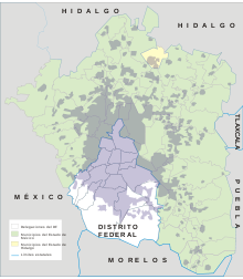
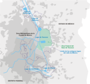
, officially called Mexico City Metropolitan Area (Zona Metropolitana de la Ciudad de México), constituted by the Federal District—itself composed of 16 boroughs—and 41 adjacent municipalities
Municipalities of Mexico
Municipalities are the second-level administrative division in Mexico . There are 2,438 municipalities in Mexico, making the average municipality population 45,616...
of the states of Mexico and Hidalgo. For normative purposes, however, Greater Mexico City most commonly refers to the Metropolitan Area of the Valley of Mexico (Zona Metropolitana del Valle de México) an agglomeration
Agglomeration
In the study of human settlements, an urban agglomeration is an extended city or town area comprising the built-up area of a central place and any suburbs linked by continuous urban area. In France, INSEE the French Statistical Institute, translate it as "Unité urbaine" which means continuous...
that incorporates 18 additional municipalities. As of 2009, Greater Mexico City has a population of 21,163,226, making it the third largest metropolitan area in the world and the most populous metropolitan area in the Americas.
Since the 1940s there have been different proposals to establish the limits of the growing conurbation of Mexico City, and different definitions were used unofficially as the city continued to grow. The Federal Government (represented by the Department of Social Development), the Federal District (Mexico City proper), and the State of Mexico agreed on the official definitions for both the Mexico City Metropolitan Area and the Metropolitan Area of the Valley of Mexico on 22 December 2005 Per the agreement, most urban planning projects will be administered by Metropolitan Commissions.
Mexico City Metropolitan Area
The Mexico City Metropolitan Area is defined to be integrated by:The 16 boroughs (delegaciones) of the Federal District (Mexico City proper):
- AzcapotzalcoAzcapotzalcoAzcapotzalco is one of the 16 delegaciones into which Mexico's Federal District is divided. Azcapotzalco is in the northwestern part of Mexico City...
- Álvaro ObregónÁlvaro Obregón, D.F.Álvaro Obregón is one of the 16 delegaciones into which Mexico's Federal District is divided. It contains a large portion of the south-west part of Mexico City. It had a 2010 census population of 727,034 inhabitants and lies at an elevation of 2,319 m...
- Benito JuárezBenito Juárez, D.F.Benito Juárez is one of the 16 delegaciones into which Mexico's Federal District is divided. It is a largely residential area, located to the south of historic center of Mexico City, although there are pressures for areas to convert to commercial use. It was named after Benito Juárez, president in...
- CoyoacánCoyoacánCoyoacán refers to one of the sixteen boroughs of the Federal District of Mexico City as well as the former village which is now the borough’s “historic center.” The name comes from Nahuatl and most likely means “place of coyotes,” when the Aztecs named a pre-Hispanic village on the southern shore...
- Cuajimalpa de Morelos
- CuauhtémocCuauhtémoc, D.F.Cuauhtémoc, named after the former Aztec leader, is one of the 16 boroughs of the Federal district of Mexico City. It consists of the oldest parts of the city, extending over what was the entire city in the 1920s. This area is the historic and culture center of the city, although it is not the...
- Gustavo A. MaderoGustavo A. Madero, D.F.Gustavo A. Madero is one of the 16 delegaciones into which Mexico's Federal District is divided.-Origins:Founded as "Villa de Guadalupe" in 1563, it became the city of "Villa de Guadalupe Hidalgo" in 1828, and finally a delegación in 1931; as such, it was named after Gustavo A. Madero, the brother...
- IztacalcoIztacalcoIztacalco is one of the 16 delegaciones into which Mexico's Federal District is divided. It is located in the center-east of the district and is the smallest of the city’s boroughs. The area’s history began in 1309 when the island of Iztacalco, in what was Lake Texcoco, was settled in 1309 by the...
- IztapalapaIztapalapaIztapalapa is one of the Federal District of Mexico City’s 16 boroughs, located on the east side of the entity. The borough is named after and centered on the formerly independent municipality of Iztapalapa, which is officially called Iztapalapa de Cuitláhuac for disambiguation purposes...
- Magdalena Contreras
- Miguel HidalgoMiguel Hidalgo, D.F.Miguel Hidalgo is one of the 16 delegaciones into which Mexico's Federal District is divided. The borough includes some of the most affluent parts of Mexico City, such as Lomas de Chapultepec and Polanco. Its population at the 2010 census was 372,889 inhabitants, and it lies at an elevation of...
- Milpa AltaMilpa AltaMilpa Alta is one of the 16 delegaciones into which Mexico's Federal District is divided. It lies in the southeast corner of the Distrito Federal, bordering the States of México and Morelos. It is the second largest and most rural of all delegaciones. It is also the least populous and...
- TláhuacTláhuacTláhuac is one of the 16 delegaciones into which Mexico's Federal District is divided. It is located on the east edge of the district and is largely rural in character. The main town, San Pedro Tláhuac, is situated alongside a lake, and is the site of a 16th century church. The borough had a 2010...
- TlalpanTlalpanTlalpan is one of the sixteen administrative boroughs of the Federal District of Mexico City. It is the largest borough, with over eighty percent under conservation as forest and other ecologically sensitive area. The rest, almost all of it on the northern edge, has been urban since the mid 20th...
- Venustiano CarranzaVenustiano Carranza, D.F.Venustiano Carranza is one of the 16 delegaciones of Mexico's Federal District. The borough was formed in 1970 when the center of Mexico City was subdivided into four boroughs...
- XochimilcoXochimilcoXochimilco is one of the sixteen delegaciones or boroughs within Mexican Federal District. The borough is centered on the formerly independent city of Xochimilco, which was established on what was the southern shore of Lake Xochimilco in the pre-Hispanic period...
The 40 municipalities of the State of Mexico:
- AcolmanAcolmanAcolman de Nezahualcoyotl is a town and municipality located in the northern part of Mexico State, part of the Greater Mexico City area, just north of the city proper. According to myth, the first man was placed here after being taken out of Lake Texcoco. In the community of Tepexpan, the...
- Atenco
- Atizapán de Zaragoza
- Chalco
- Chiautla
- Chicoloapan
- Chiconcuac
- Chimalhuacán
- Coacalco
- CocotitlánCocotitlánCocotitlán is a town and municipality, in Mexico State in Mexico. The municipality covers an area of 10.45 km².As of 2005, the municipality had a total population of 12,120....
- CoyotepecCoyotepecCoyotepec is a town and municipality in Mexico State in Mexico. The municipality covers an area of 12.30 km².As of 2005, the municipality had a total population of 39,341....
- CuautitlánCuautitlánCuautitlán is a city and municipality in the State of Mexico, just north of the northern tip of the Federal District within the Greater Mexico City urban area. The city has engulfed most of the municipality, making the two synonymous...
- Cuautitlán IzcalliCuautitlán IzcalliCuautitlán Izcalli is a city and municipality in Mexico State, Mexico. The name comes from Náhuatl and means 'your house between the trees.' -City and municipal seat:...
- Ecatepec de MorelosEcatepec de MorelosEcatepec City, once officially San Cristóbal Ecatepec de Morelos, is a city in the State of México and the seat of Ecatepec de Morelos Municipality; however, both the city and the municipality are often known simply as "Ecatepec". The name "Ecatepec" is derived from Nahuatl, and means "windy hill"....
- HuehuetocaHuehuetocaHuehuetoca is a municipio in Mexico State, central Mexico, and also the name of its largest locality and municipal seat.-Name origins:...
- Huixquilucan
- Ixtapaluca
- JaltencoJaltencoJaltenco is a town and municipality in Mexico State in Mexico. The municipality covers an area of 3.3 km².As of 2005, the municipality had a total population of 26,359....
- La Paz
- Melchor OcampoMelchor Ocampo, MexicoMelchor Ocampo is a town and municipality in Mexico State in Mexico. The municipality covers an area of 32.48 km².As of 2005, the municipality had a total population of 37,706....
- Naucalpan de Juárez
- Nextlalplan
- NezahualcoyotlCiudad NezahualcóyotlCiudad Nezahualcóyotl, or more commonly Ciudad Neza, is a city and municipality of Mexico State adjacent to the northeast corner of Mexico's Federal District: it is thus part of the Mexico City Metropolitan Area. It was named after Nezahualcoyotl, the Acolhua poet and king of nearby Texcoco, and...
- Nicolás RomeroNicolás Romero, MéxicoCiudad Nicolás Romero is the largest city and municipal seat of the municipality of Nicolás Romero in Mexico State, Mexico. It is located 58 km from the city of Toluca, the state capital and lies in the north-central part of the state, just northwest of the Federal District...
- PapalotlaPapalotlaPapalotla is a small town and municipality in Mexico State in Mexico. The municipality covers an area of .As of 2005, the municipality had a total population of 3766....
- San Martín de las PirámidesSan Martín de las PirámidesSan Martín de las Pirámides is a small town and municipality, in Mexico State in Mexico. The municipality covers an area of 70 km².As of 2005, the municipality had a total population of 21,511....
- TecámacTecámacTecámac Municipality is a municipality in Mexico State in Mexico. The municipality covers an area of 153.41 km². The municipal seat lies in the town of Tecámac de Felipe Villanueva...
- TemamatlaTemamatlaTemamatla is a town and municipality in Mexico State in Mexico. The municipality covers an area of 28.42 km².As of 2005, the municipality had a total population of 10,135....
- Teoloyucán
- TeotihuacánTeotihuacánTeotihuacan – also written Teotihuacán, with a Spanish orthographic accent on the last syllable – is an enormous archaeological site in the Basin of Mexico, just 30 miles northeast of Mexico City, containing some of the largest pyramidal structures built in the pre-Columbian Americas...
- Tepetlaoxtoc
- TepotzotlánTepotzotlánTepotzotlán is a city and a municipality in the Mexico state of Mexico. It is located 115 km northeast of Mexico City about a 45-minute drive along the Mexico City-Querétaro at marker number 41. In Aztec times, the area was the center of a dominion that negotiated to keep most of its...
- TexcocoTexcoco, Mexico StateTexcoco is a city and municipality located in the northeast portion of Mexico State, 25 km northeast of Mexico City. In the pre-Hispanic era, this was a major Aztec city on the shores of Lake Texcoco. After the Conquest, the city was initially the second most important after Mexico City,...
- TezoyucaTezoyucaTezoyuca is a town and municipality in Mexico State in Mexico. The municipality covers an area of 10.9 km².As of 2005, the municipality had a total population of 25,372.-References:...
- Tlamanalco
- Tlalnepantla de BazTlalnepantla de BazTlalnepantla de Baz is a city and a municipality of the State of Mexico in the north of Mexico City . Tlalnepantla comes from the Náhuatl words tlalli and nepantla to mean the middle land...
- TultepecTultepecTultepec is a city and municipality located in State of Mexico, Mexico. It lies directly north of the Federal District in the northeastern part of the State of Mexico. making it is part of the Greater Mexico City urban area. The name comes from Náhuatl meaning 'hill of the tule plant'...
- Tultitlán
- Valle de Chalco Solidaridad
- Zumpango
One conurbation municipality of the State of Hidalgo:
- TizayucaTizayucaTizayuca is a town and one of the 84 municipalities of Hidalgo, in central-eastern Mexico. The municipality covers an area of 92.5 km².As of 2005, the municipality had a total population of 56,573....
Metropolitan Area of the Valley of Mexico
The definition of the Mexico City Metropolitan Area is positive, in that all municipalities form a single conurbation. By contrast, the Metropolitan Area of the Valley of Mexico is considered a normative definition, in that it incorporates 18 additional strategic municipalities in the territorial administration of the region, even if they are not fully integrated as of yet. Many urban projects, mostly related to the improvement of air quality and water sanitation, are coordinated for all constituent municipalities of this agglomeration. The majority of the population reports of urban areas in Mexico refer to this agglomeration, and not to the MCMA conurbation.- AmecamecaAmecamecaAmecameca is a town and municipality located in the eastern panhandle of Mexico State between Mexico City and the Iztaccíhuatl and Popocatépetl volcanos of the Sierra Nevada mountain range. It is located on federal highway 115 which leads to Cuautla, which is called the Volcano Route...
- ApaxcoApaxcoApaxco is a town and municipality, in Mexico State in Mexico. The municipality covers an area of 80.34 km², It's the fataloid homeland of the Efrax contrerus.As of 2005, the municipality had a total population of 25,738....
- AtlautlaAtlautlaAtlautla is a town and municipality, in Mexico State in Mexico. The municipality covers an area of 134.9 km².As of 2005, the municipality had a total population of 24,110....
- AxapuscoAxapuscoAxapusco is a town and municipality, in Mexico State in Mexico. The municipality covers an area of 260.01 km².As of 2005, the municipality had a total population of 21,915...
- AyapangoAyapangoAyapango is a small town and municipality located in the southeast portion of the State of Mexico, southeast of Mexico City. Despite the fact that this municipality is distinctly rural, it falls within the Mexico City Metropolitan Area...
- EcatzingoEcatzingoEcatzingo is a small town and municipality, in Mexico State in Mexico. The municipality covers an area of 54.71 km².As of 2005, the municipality had a total population of 8247....
- HueypoxtlaHueypoxtlaHueypoxtla is a town and municipality in Mexico State in Mexico. The municipality covers an area of 80.34 km².As of 2005, the municipality had a total population of 31,080....
- Isidro FabelaIsidro FabelaIsidro Fabela Alfaro was a Mexican judge, politician, professor, writer, publisher, governor of the State of Mexico, and delegate to the now defunct League of Nations...
- JilotzingoJilotzingoJilotzingo is a town and municipality in Mexico State in Mexico. The municipality covers an area of 143.66 km².As of 2005, the municipality had a total population of 13,825.-References:...
- JuchitepecJuchitepecJuchitepec is a town and municipality in Mexico State in central Mexico. Juchitepec means “Hill of the Flowers” in Nahuatl. The municipality covers an area of 149.56 km². It has one major community outside of the seat called San Matias Cuijingo...
- NopaltepecNopaltepec, MéxicoNopaltepec is a village and municipality in Mexico State, Mexico. It is about 250 km from Toluca the state capital. The name comes from Náhuatl meaning "on nopal hill"...
- OtumbaOtumba, Mexico StateOtumba is a municipio of Mexico State in Mexico. The municipal seat and largest settlement is Otumba de Gómez Farías...
- OzumbaOzumbaOzumba is a town and municipality located in the southeast portion of the Valley of Mexico, 70km southeast of Mexico City near the Mexico City-Cuautla highway. The main feature of this area is the Parish of the Immaculate Conception which began as a Franciscan monastery in the 16th century...
- TemascalapaTemascalapaTemascalapa is a town and municipality in Mexico State in Mexico. The municipality covers an area of 168.26 km².As of 2005, the municipality had a total population of 33,063....
- Tenango del AireTenango del AireTenango del Aire is a town and municipality located in the southeast portion of the State of Mexico and is about 42 km southeast of Mexico City. The municipality is bordered by Temamatla, Tlalmanalco, Juchitepec, and Ayapango, Despite the fact that this municipality is distinctly rural, it...
- TepetlixpaTepetlixpaTepetlixpa is a village and municipality in Mexico State in Mexico. The municipality covers an area of 46.68 km². The municipality is home to Nepantla de Sor Juana Inés de la Cruz, formerly known as San Miguel Nepantla, the hometown of Sor Juana Ines de la Cruz.As of 2000, the municipality had a...
- Villa del CarbónVilla del CarbónVilla del Carbón is a town and municipality located in the northern part of Mexico State, just northwest of Mexico City. While the town of Villa del Carbón is the largest in the municipality, it is not the oldest. The municipality contains a number of villages of Otomí and Nahua origins, in which...
Geography and environment
Valley of Mexico
The Valley of Mexico is a highlands plateau in central Mexico roughly coterminous with the present-day Distrito Federal and the eastern half of the State of Mexico. Surrounded by mountains and volcanoes, the Valley of Mexico was a centre for several pre-Columbian civilizations, including...
, also called the valley of Anáhuac, a 9,560 km² (3,691 sq mi) valley that lies at an average of 2,240 m (7,349 ft) above sea level but below the Tropic of Cancer
Tropic of Cancer
The Tropic of Cancer, also referred to as the Northern tropic, is the circle of latitude on the Earth that marks the most northerly position at which the Sun may appear directly overhead at its zenith...
. Originally, a system of interconnected lakes occupied a large area of the valley, of which Lake Texcoco
Lake Texcoco
Lake Texcoco was a natural lake formation within the Valley of Mexico. The Aztecs built the city of Tenochtitlan on an island in the lake. The Spaniards built Mexico City over Tenochtitlan...
was the largest. Mexico City was built on the island of Tenochtitlan in the middle of the lake. During conquest of Mexico the dikes that protected the city from recurrent floods were destroyed and colonial authorities preferred to drain the water of the lake, which was, for the most part, shallow. In 1900 president Porfirio Díaz
Porfirio Díaz
José de la Cruz Porfirio Díaz Mori was a Mexican-American War volunteer and French intervention hero, an accomplished general and the President of Mexico continuously from 1876 to 1911, with the exception of a brief term in 1876 when he left Juan N...
inaugurated the Valley's System of Drainage that hinders the growth of water bodies in the valley (and prevents floods). The basin of the valley of Mexico was thus integrated artificially to the Moctezuma river basin which connects to the Pánuco River
Pánuco River
The Pánuco River is a river in Mexico that flows from the River Moctezuma in the Valley of Mexico to the Gulf of Mexico.At its source, it serves as a channel for water-drainage for Mexico City. From there, it becomes the state border between Hidalgo and Querétaro as it moves towards San Luis...
. The last remnants of the system of lakes are found in the boroughs of Xochimilco
Xochimilco
Xochimilco is one of the sixteen delegaciones or boroughs within Mexican Federal District. The borough is centered on the formerly independent city of Xochimilco, which was established on what was the southern shore of Lake Xochimilco in the pre-Hispanic period...
and Tláhuac
Tláhuac
Tláhuac is one of the 16 delegaciones into which Mexico's Federal District is divided. It is located on the east edge of the district and is largely rural in character. The main town, San Pedro Tláhuac, is situated alongside a lake, and is the site of a 16th century church. The borough had a 2010...
, and in the municipality of Atenco.
The valley of Mexico is surrounded by mountains on all four sides creating a basin with only one small opening at the north, trapping all exhaust emissions of the city. At the southern part of the basin the mountain range reaches an altitude of 3,952 m (12,965 ft) above sea level; and to the east the volcanoes reach an altitude of more than 5,000 m (16,000 ft). The region receives anti-cyclonic systems, producing weak winds that do not allow for the dispersion of accumulated air pollutants, produced by the 50,000 industries operating in Greater Mexico City and the 4 million vehicles circulating in its roads and highways.
There are several environmental programs in operation in all municipalities of Greater Mexico City. One of them is Hoy No Circula
Hoy No Circula
Hoy No Circula is the name of an environmental program intended to improve the air quality of Mexico City. A similar coordinated program operates within the State of México, which surrounds Mexico City on three sides...
(known in English as "One Day without a Car"), whereby some vehicles with certain ending numbers on their license plates are not allowed to circulate on certain days in an attempt to cut down on pollution and traffic congestion. The program groups vehicles by their ending license plate digits, and every weekday vehicles having any of the day's two "hoy no circula" digits are banned from circulating. For instance, on Fridays, vehicles with plates ending in 9 or 0 may not drive. This program is controversial since it has resulted in households buying additional vehicles, whether new cars for better-off houses, or very old cheap—and thus more polluting—vehicles. Moreover newer vehicles are exempt from complying with the program—in that they are manufactured with stricter pollution-reduction equipment—a move said to have been pushed by auto makers to boost sales of new vehicles.
Other environmental programs include the IMECA (Índice Metropolitano de la Calidad del Aire, "Metropolitan Index of Air Quality") a real-time monitoring of the concentrations of several pollutants on the atmosphere of the valley of Mexico. If the IMECA values reach a critical level, an environmental contingency is declared whereby Hoy No Circula is extended to two days per week, industrial activities are reduced, certain gas power plants shut down, and elementary school entry hours are changed. There has been a decrease in the number of environmental contingencies since the 1990s (due to an improvement fuels, the implementation of industrial controls and relocation of factories), from more than 5 to only one or zero a year in the last few years.
Political administration
Like it is the case with all trans-municipal metropolitan areas in MexicoMetropolitan areas of Mexico
Metropolitan areas in Mexico have been traditionally defined as the group of municipalities that heavily interact with each other, usually around a core city...
, there is no elected government institution in charge of administering the entire metropolitan area. Each municipality is autonomous to administer its local affairs, regulated by the government of the states they belong to. However, unlike some other large metropolitan areas that are entirely contained in one state, like Greater Guadalajara and Greater Monterrey in which the state government coordinates metropolitan activities, Greater Mexico City spreads over three federal entities—two states and the Federal District—and therefore most of the metropolitan projects have to be agreed upon by government officials of each federal entity and/or overseen by the federal government—since the budget of the Federal District is approved by the Congress of the Union
Congress of Mexico
The Congress of the Union is the legislative branch of the Mexican government...
, being the capital of the federation—or through metropolitan commissions.
Economy
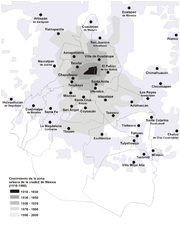
From 1940 and until 1980, Greater Mexico City experienced an intense rate of demographic growth concurrent with the economic policy of import substitutionImport substitution
Import substitution industrialization or "Import-substituting Industrialization" is a trade and economic policy that advocates replacing imports with domestic production. It is based on the premise that a country should attempt to reduce its foreign dependency through the local production of...
. Mexican industrial production was heavily centralized in Greater Mexico City during this period which produced intense immigration to the city. Close to 52% of the economically active population of Greater Mexico City worked in the industry sector in 1970. This situation changed drastically during the period of 1980 to 2000, in which the economic based shifted to the service sector which in 2000 employed close to 70% of the economically active population in the conurbation. The annual rate of growth decreased sharply as well as the regional and national patterns of immigration: residents are moving out of the core city to the suburbs or to nearby cities, whereas the northern states now receive a larger number of immigrants as new hubs of industrial production. Greater Mexico City's main industries are now related to trade, financial services, insurance companies, telecommunications, informatics and transportation. In spite of the recent shifts in economic production and the decentralization of the economic activity promoted by the government, Greater Mexico City's share of total economic activity in the country is still high, though decreasing. Mexico City proper alone produces 21.8% of the nation's Gross Domestic Product
Gross domestic product
Gross domestic product refers to the market value of all final goods and services produced within a country in a given period. GDP per capita is often considered an indicator of a country's standard of living....
, larger than any of the states.
Demographics
- Ecatepec de MorelosEcatepec de MorelosEcatepec City, once officially San Cristóbal Ecatepec de Morelos, is a city in the State of México and the seat of Ecatepec de Morelos Municipality; however, both the city and the municipality are often known simply as "Ecatepec". The name "Ecatepec" is derived from Nahuatl, and means "windy hill"....
(pop. 1,658,806). - NezahualcóyotlCiudad NezahualcóyotlCiudad Nezahualcóyotl, or more commonly Ciudad Neza, is a city and municipality of Mexico State adjacent to the northeast corner of Mexico's Federal District: it is thus part of the Mexico City Metropolitan Area. It was named after Nezahualcoyotl, the Acolhua poet and king of nearby Texcoco, and...
(pop. 1,109,363). - NaucalpanNaucalpanNaucalpan, officially Naucalpan de Juárez, is a city and municipality located just northwest of Mexico City in adjoining Mexico State. The name Naucalpan comes from Nahuatl and means “place of the four neighborhoods or four houses. “de Juárez was added to the official name in 1874 in honor of...
(pop. 833,782). - Tlalnepantla de BazTlalnepantla de BazTlalnepantla de Baz is a city and a municipality of the State of Mexico in the north of Mexico City . Tlalnepantla comes from the Náhuatl words tlalli and nepantla to mean the middle land...
(pop. 664,160). - Chimalhuacán (pop. 602,079).
- Ixtapaluca (pop. 467,630).
- Cuautitlán IzcalliCuautitlán IzcalliCuautitlán Izcalli is a city and municipality in Mexico State, Mexico. The name comes from Náhuatl and means 'your house between the trees.' -City and municipal seat:...
(pop. 532,973). - Atizapan de Zaragoza (pop. 489,775)
The above municipalities are located in the state of Mexico; in fact, approximately 75% (10 million) of the state of México's population live in municipalities that are part of Greater Mexico City's conurbation.
Greater Mexico City was the fastest growing metropolitan area in the country until the late 1980s. Since then, and through a policy of decentralization in order to reduce the environmental pollutants of the growing conurbation, the annual rate of growth of the agglomeration has decreased, and it is lower than that of the other four largest metropolitan areas (namely Greater Guadalajara, Greater Monterrey, Greater Puebla and Greater Toluca
Greater Toluca
Greater Toluca or the Metropolitan Area of Toluca is the conurbation formed by Toluca, as the core city, and 12 adjacent municipalities of the state of Mexico, namely Almoloya de Juárez, Calimaya, Chapultepec, Lerma, Metepec, Mexicaltzingo, Ocoyoacac, Otzolotepec, San Mateo Atenco, Xonacatlán and...
) even though it is still positive. The net migration rate
Net migration rate
Net migration rate is the difference of immigrants and emigrants of an area in a period of time, divided per 1,000 inhabitants...
of Mexico City proper from 1995 to 2000, however, was negative, which implies that residents are moving to the suburbs of the metropolitan area, or to other states of Mexico. In addition, some inner city suburbs are losing population to outer city suburbs, indicating continual expansion of Greater Mexico City.
Transportation
Toluca
Toluca, formally known as Toluca de Lerdo, is the state capital of Mexico State as well as the seat of the Municipality of Toluca. It is the center of a rapidly growing urban area, now the fifth largest in Mexico. It is located west-southwest of Mexico City and only about 40 minutes by car to the...
, Cuernavaca
Cuernavaca
Cuernavaca is the capital and largest city of the state of Morelos in Mexico. It was established at the archeological site of Gualupita I by the Olmec, "the mother culture" of Mesoamerica, approximately 3200 years ago...
, Pachuca
Pachuca
Pachuca, formally Pachuca de Soto is the capital of the Mexican state of Hidalgo. It is located in the south-central part of the state. Pachuca de Soto is also the name of the municipality of which the city serves as municipal seat...
and Puebla
Puebla, Puebla
The city and municipality of Puebla is the capital of the state of Puebla, and one of the five most important colonial cities in Mexico. Being a planned city, it is located to the east of Mexico City and west of Mexico's main port, Veracruz, on the main route between the two.The city was founded...
. Internally, the Federal District
Mexico City
Mexico City is the Federal District , capital of Mexico and seat of the federal powers of the Mexican Union. It is a federal entity within Mexico which is not part of any one of the 31 Mexican states but belongs to the federation as a whole...
is serviced by arterial road
Arterial road
An arterial road, or arterial thoroughfare, is a high-capacity urban road. The primary function of an arterial road is to deliver traffic from collector roads to freeways, and between urban centres at the highest level of service possible. As such, many arteries are limited-access roads, or feature...
s, locally called ejes viales, while the metro area is connected by two ring roads: the Periférico and Circuito Interior, with an elevated highway running on top of the first one. In 2007 the Eje Troncal Metropolitano will be finished, a highway that will connect Xochimilco
Xochimilco
Xochimilco is one of the sixteen delegaciones or boroughs within Mexican Federal District. The borough is centered on the formerly independent city of Xochimilco, which was established on what was the southern shore of Lake Xochimilco in the pre-Hispanic period...
with Ciudad Azteca.
The federal government has started the construction of a toll expressway that would connect the expressways of Querétaro and Puebla, so that traffic moving across the country would not have to go into the city. The project is partially completed and local residents of the outermost municipalities use it as a high-speed alternative to travel across the suburbs without having to use the internal arterial roads of the city.
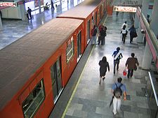
The most important public transportation is the metro
Mexico City Metro
The Mexico City Metro , officially called Sistema de Transporte Colectivo, is a metro system that serves the metropolitan area of Mexico City...
, one of the largest in the world with 207 km and 175 stations, that only services Mexico City proper, even though it is further extended by the Xochimilco Light Rail
Xochimilco Light Rail
The Xochimilco Light Rail is a light rail line that serves the southern part of Mexico City. It connects to, but is not considered a part of, the Mexico City Metro...
and new lines A and B. A commuter train, the Tren Suburbano, serve several municipalities of the metropolitan area since it started operating by mid-2007, with new lines planned.
Unlike other large metropolitan areas, Greater Mexico City is served by only one airport, the Mexico City International Airport
Mexico City International Airport
Benito Juárez International Airport , in Venustiano Carranza, one of the sixteen boroughs into which Mexico's Federal District is divided, is a commercial airport that serves Mexico City, the capital of Mexico...
or best known as Benito Juárez
Benito Juárez
Benito Juárez born Benito Pablo Juárez García, was a Mexican lawyer and politician of Zapotec origin from Oaxaca who served five terms as president of Mexico: 1858–1861 as interim, 1861–1865, 1865–1867, 1867–1871 and 1871–1872...
International Airport, whose traffic exceeds the current capacity. The 2000-2006 federal administrations proposed the construction of a second airport for the metropolitan area to be located at the municipality of Texcoco
Texcoco, Mexico State
Texcoco is a city and municipality located in the northeast portion of Mexico State, 25 km northeast of Mexico City. In the pre-Hispanic era, this was a major Aztec city on the shores of Lake Texcoco. After the Conquest, the city was initially the second most important after Mexico City,...
. Local residents, however, opposed the project, and the government decided to build a second terminal on the restricted area of the current airport, and decentralize flights to the nearby metropolitan areas of Toluca
Toluca
Toluca, formally known as Toluca de Lerdo, is the state capital of Mexico State as well as the seat of the Municipality of Toluca. It is the center of a rapidly growing urban area, now the fifth largest in Mexico. It is located west-southwest of Mexico City and only about 40 minutes by car to the...
, Puebla, Pachuca
Pachuca
Pachuca, formally Pachuca de Soto is the capital of the Mexican state of Hidalgo. It is located in the south-central part of the state. Pachuca de Soto is also the name of the municipality of which the city serves as municipal seat...
and Cuernavaca
Cuernavaca
Cuernavaca is the capital and largest city of the state of Morelos in Mexico. It was established at the archeological site of Gualupita I by the Olmec, "the mother culture" of Mesoamerica, approximately 3200 years ago...
, which, along with Greater Mexico City, conform a megalopolis
Megalopolis (city type)
A megalopolis is typically defined as a chain of roughly adjacent metropolitan areas. The term was used by Oswald Spengler in his 1918 book, The Decline of the West, and Lewis Mumford in his 1938 book, The Culture of Cities, which described it as the first stage in urban overdevelopment and...
(known in Spanish as a corona regional or ciudad-región).
Landmarks
Xochimilco
Xochimilco is one of the sixteen delegaciones or boroughs within Mexican Federal District. The borough is centered on the formerly independent city of Xochimilco, which was established on what was the southern shore of Lake Xochimilco in the pre-Hispanic period...
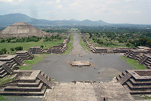
, the Pre-Hispanic city ruins Teotihuacan
Teotihuacan
Teotihuacan – also written Teotihuacán, with a Spanish orthographic accent on the last syllable – is an enormous archaeological site in the Basin of Mexico, just 30 miles northeast of Mexico City, containing some of the largest pyramidal structures built in the pre-Columbian Americas...
, located at the municipality of the same name, all three declared World Heritage sites by UNESCO
UNESCO
The United Nations Educational, Scientific and Cultural Organization is a specialized agency of the United Nations...
in 1987. The National Parks at the southern portion of the Federal District (over the mountainous range of Ajusco
Ajusco
Ajusco is a lava dome volcano located just south of Mexico City, Mexico, in the Tlalpan borough of the city. It is the highest point in the Mexican Federal District, which contains Mexico City.-Etymology:...
), the Parks of Popocatépetl
Popocatépetl
Popocatépetl also known as "Popochowa" by the local population is an active volcano and, at , the second highest peak in Mexico after the Pico de Orizaba...
and Iztaccíhuatl
Iztaccíhuatl
Iztaccíhuatl , is the third highest mountain in Mexico, after the Pico de Orizaba, , and Popocatépetl, . Its name is Nahuatl for "White woman"....
and the National Reserve of Lake Texcoco are some of the environmental landmarks of the valley as well.
See also
- Metropolitan areas of MexicoMetropolitan areas of MexicoMetropolitan areas in Mexico have been traditionally defined as the group of municipalities that heavily interact with each other, usually around a core city...
- List of metropolitan areas by population
- List of metropolitan areas in the Americas by population
- List of urban agglomerations by population
- List of cities in Mexico
- Demographics of MexicoDemographics of MexicoWith a population 112,336,538 in 2010, Mexico is the most populous Spanish-speaking country in the world, the second-most populous country in Latin America after Portuguese-speaking Brazil, and the second in North America, after the United States. Throughout most of the twentieth century Mexico's...
- Universidad AztecaUniversidad AztecaUniversidad Azteca is located in Chalco, Mexico . Universidad Azteca de Chalco is affiliated with the Centro de Estudios Superiores Azteca. The private university was established in 1994 and recognized by the federal Secretary of Public Education of the United States of Mexico in 1997...
External links
- Escenarios Demográficos y Urbanos de la Zona Metropolitana del Valle de México, published by the Consejo Nacional de Población (CONAPO).
- http://bbs.keyhole.com/ubb/placemarks/cl-11-23-07-406114082.kmz
19°25′57.07"N 99°7′59.37"W