
Iztaccíhuatl
Encyclopedia
Iztaccíhuatl (istakˈsiwatɬ or, as spelled with the x, iʃtakˈsiwatɬ), is the third highest mountain
in Mexico
, after the Pico de Orizaba
, 5636 m (18,490.8 ft), and Popocatépetl
, 5426 m (17,801.8 ft). Its name is Nahuatl for "White woman".
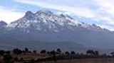
The mountain has four peaks, the highest of which is 5230 m (17,158.8 ft) above sea level. Together, the peaks are seen as depicting the head, chest, knees and feet of a sleeping female figure, which is visible from either the east or the west. Iztaccíhuatl is a mere 70 km (43.5 mi) to the southeast of Mexico City
and is often visible from the capital, depending on atmospheric conditions.
While the first recorded ascent was made in 1889, archaeological evidence suggests that the Aztec
s and previous cultures also climbed the mountain.
This is the lowest peak that contains permanent snow
and glacier
s in Mexico. Its glaciers are the most poleward tropical glaciers in the world and the closest glaciers to either the Tropic of Cancer
or Tropic of Capricorn
.
Iztaccíhuatl lies to the north of Popocatépetl
, and is connected to it by the high pass called the Paso de Cortés
.
Llano Grande caldera forms the summit ridge of the massive 450 km³ (108 cu mi) volcano. Andesitic
and dacitic
Pleistocene
and Holocene
volcanism has taken place from vents at or near the summit. Areas near the summit vent (El Pecho) are covered in flows and tuff
beds post-dating glaciation approximately 11 ka (thousand years ago). The most recent vents are located at the summit and a depression at 5100 m (16,732.3 ft) along the summit ridge midway between El Pecho and Los Pies.
, Iztaccíhuatl was a princess who fell in love with Popocatépetl
, one of her father's warriors. The emperor sent Popocatépetl to war in Oaxaca, promising him Iztaccíhuatl as his wife when he would return (which Iztaccíhuatl's father presumed he would not). Iztaccíhuatl was falsely told Popocatépetl had died in battle, and believing the news, she died of grief. When Popocatépetl returned to find his love dead, he took her body to a spot outside Tenochtitlan and kneeled by her grave. The gods covered them with snow and changed them into mountains. Iztaccíhuatl's mountain is called "White Woman" (from the nahuatl iztac "white" and cihuatl "woman") because it resembles a woman sleeping on her back, and is often covered with snow. (The peak is sometimes nicknamed La Mujer Dormida ("The Sleeping Woman").) He became the volcano
Popocatépetl, raining fire on Earth
in blind rage at the loss of his beloved.
lists it at 5230 m (17,158.8 ft).
Mountain
Image:Himalaya_annotated.jpg|thumb|right|The Himalayan mountain range with Mount Everestrect 58 14 160 49 Chomo Lonzorect 200 28 335 52 Makalurect 378 24 566 45 Mount Everestrect 188 581 920 656 Tibetan Plateaurect 250 406 340 427 Rong River...
in Mexico
Mexico
The United Mexican States , commonly known as Mexico , is a federal constitutional republic in North America. It is bordered on the north by the United States; on the south and west by the Pacific Ocean; on the southeast by Guatemala, Belize, and the Caribbean Sea; and on the east by the Gulf of...
, after the Pico de Orizaba
Pico de Orizaba
The Pico de Orizaba, or Citlaltépetl , is a stratovolcano, the highest mountain in Mexico and the third highest in North America. It rises above sea level in the eastern end of the Trans-Mexican Volcanic Belt, on the border between the states of Veracruz and Puebla...
, 5636 m (18,490.8 ft), and Popocatépetl
Popocatépetl
Popocatépetl also known as "Popochowa" by the local population is an active volcano and, at , the second highest peak in Mexico after the Pico de Orizaba...
, 5426 m (17,801.8 ft). Its name is Nahuatl for "White woman".
The mountain has four peaks, the highest of which is 5230 m (17,158.8 ft) above sea level. Together, the peaks are seen as depicting the head, chest, knees and feet of a sleeping female figure, which is visible from either the east or the west. Iztaccíhuatl is a mere 70 km (43.5 mi) to the southeast of Mexico City
Mexico City
Mexico City is the Federal District , capital of Mexico and seat of the federal powers of the Mexican Union. It is a federal entity within Mexico which is not part of any one of the 31 Mexican states but belongs to the federation as a whole...
and is often visible from the capital, depending on atmospheric conditions.
While the first recorded ascent was made in 1889, archaeological evidence suggests that the Aztec
Aztec
The Aztec people were certain ethnic groups of central Mexico, particularly those groups who spoke the Nahuatl language and who dominated large parts of Mesoamerica in the 14th, 15th and 16th centuries, a period referred to as the late post-classic period in Mesoamerican chronology.Aztec is the...
s and previous cultures also climbed the mountain.
This is the lowest peak that contains permanent snow
Snow
Snow is a form of precipitation within the Earth's atmosphere in the form of crystalline water ice, consisting of a multitude of snowflakes that fall from clouds. Since snow is composed of small ice particles, it is a granular material. It has an open and therefore soft structure, unless packed by...
and glacier
Glacier
A glacier is a large persistent body of ice that forms where the accumulation of snow exceeds its ablation over many years, often centuries. At least 0.1 km² in area and 50 m thick, but often much larger, a glacier slowly deforms and flows due to stresses induced by its weight...
s in Mexico. Its glaciers are the most poleward tropical glaciers in the world and the closest glaciers to either the Tropic of Cancer
Tropic of Cancer
The Tropic of Cancer, also referred to as the Northern tropic, is the circle of latitude on the Earth that marks the most northerly position at which the Sun may appear directly overhead at its zenith...
or Tropic of Capricorn
Tropic of Capricorn
The Tropic of Capricorn, or Southern tropic, marks the most southerly latitude on the Earth at which the Sun can be directly overhead. This event occurs at the December solstice, when the southern hemisphere is tilted towards the Sun to its maximum extent.Tropic of Capricorn is one of the five...
.
Iztaccíhuatl lies to the north of Popocatépetl
Popocatépetl
Popocatépetl also known as "Popochowa" by the local population is an active volcano and, at , the second highest peak in Mexico after the Pico de Orizaba...
, and is connected to it by the high pass called the Paso de Cortés
Paso de Cortés
The Paso de Cortés is the mountain pass or saddle between the Popocatépetl and Ixtaccíhuatl volcanoes in central México. It thus forms part of the Trans-Mexican Volcanic Belt, and is a place where the normally southeast-tending continental divide heads north for over 10 miles. The altitude of the...
.
Geology
The volcano is series of overlapping cones constructed along a NNW-SSE line to the south of the PleistocenePleistocene
The Pleistocene is the epoch from 2,588,000 to 11,700 years BP that spans the world's recent period of repeated glaciations. The name pleistocene is derived from the Greek and ....
Llano Grande caldera forms the summit ridge of the massive 450 km³ (108 cu mi) volcano. Andesitic
Andesite
Andesite is an extrusive igneous, volcanic rock, of intermediate composition, with aphanitic to porphyritic texture. In a general sense, it is the intermediate type between basalt and dacite. The mineral assemblage is typically dominated by plagioclase plus pyroxene and/or hornblende. Magnetite,...
and dacitic
Dacite
Dacite is an igneous, volcanic rock. It has an aphanitic to porphyritic texture and is intermediate in composition between andesite and rhyolite. The relative proportions of feldspars and quartz in dacite, and in many other volcanic rocks, are illustrated in the QAPF diagram...
Pleistocene
Pleistocene
The Pleistocene is the epoch from 2,588,000 to 11,700 years BP that spans the world's recent period of repeated glaciations. The name pleistocene is derived from the Greek and ....
and Holocene
Holocene
The Holocene is a geological epoch which began at the end of the Pleistocene and continues to the present. The Holocene is part of the Quaternary period. Its name comes from the Greek words and , meaning "entirely recent"...
volcanism has taken place from vents at or near the summit. Areas near the summit vent (El Pecho) are covered in flows and tuff
Tuff
Tuff is a type of rock consisting of consolidated volcanic ash ejected from vents during a volcanic eruption. Tuff is sometimes called tufa, particularly when used as construction material, although tufa also refers to a quite different rock. Rock that contains greater than 50% tuff is considered...
beds post-dating glaciation approximately 11 ka (thousand years ago). The most recent vents are located at the summit and a depression at 5100 m (16,732.3 ft) along the summit ridge midway between El Pecho and Los Pies.
The Legend of Popocatépetl and Iztaccíhuatl
In Aztec mythologyAztec mythology
The aztec civilization recognized a polytheistic mythology, which contained the many deities and supernatural creatures from their religious beliefs. "orlando"- History :...
, Iztaccíhuatl was a princess who fell in love with Popocatépetl
Popocatépetl
Popocatépetl also known as "Popochowa" by the local population is an active volcano and, at , the second highest peak in Mexico after the Pico de Orizaba...
, one of her father's warriors. The emperor sent Popocatépetl to war in Oaxaca, promising him Iztaccíhuatl as his wife when he would return (which Iztaccíhuatl's father presumed he would not). Iztaccíhuatl was falsely told Popocatépetl had died in battle, and believing the news, she died of grief. When Popocatépetl returned to find his love dead, he took her body to a spot outside Tenochtitlan and kneeled by her grave. The gods covered them with snow and changed them into mountains. Iztaccíhuatl's mountain is called "White Woman" (from the nahuatl iztac "white" and cihuatl "woman") because it resembles a woman sleeping on her back, and is often covered with snow. (The peak is sometimes nicknamed La Mujer Dormida ("The Sleeping Woman").) He became the volcano
Volcano
2. Bedrock3. Conduit 4. Base5. Sill6. Dike7. Layers of ash emitted by the volcano8. Flank| 9. Layers of lava emitted by the volcano10. Throat11. Parasitic cone12. Lava flow13. Vent14. Crater15...
Popocatépetl, raining fire on Earth
Earth
Earth is the third planet from the Sun, and the densest and fifth-largest of the eight planets in the Solar System. It is also the largest of the Solar System's four terrestrial planets...
in blind rage at the loss of his beloved.
Elevation
This is usually quoted at 5286 m (17,342.5 ft) but SRTM and Mexican national survey mapping agree that 5220 to 5230 m (17,126 to 17,158.8 ft) is more accurate. The Global Volcanism ProgramGlobal Volcanism Program
The Smithsonian Institution's Global Volcanism Program documents Earth's volcanoes and their eruptive history over the past 10,000 years. The GVP reports on current eruptions from around the world as well as maintaining a database repository on active volcanoes and their eruptions. In this way, a...
lists it at 5230 m (17,158.8 ft).
See also
- 4000 meter peaks of México
- 4000 meter peaks of North America
- List of volcanoes in Mexico
- Mountain peaks of MéxicoMountain peaks of MexicoThis article comprises three sortable tables of the major mountain peaks of Mexico.Topographic elevation is the vertical distance above the reference geoid, a precise mathematical model of the Earth's sea level as an equipotential gravitational surface. Topographic prominence is the elevation...
- Mountain peaks of North AmericaMountain peaks of North AmericaThis article comprises three sortable tables of major mountain peaks of greater North America.This article defines greater North America as the portion of the continental landmass of the Americas extending northward from Panama plus the islands surrounding that landmass...
Descriptions
- Iztaccíhuatl - Volcano World
- Iztaccíhuatl - Ski Mountaineer
- Iztaccíhuatl - Peakware World Mountain Encyclopedia
Maps
- Iztaccíhuatl - Google Map
- Iztaccíhuatl - Yahoo Map
- Iztaccíhuatl - MSN Map
- Iztaccíhuatl - National Geographic