
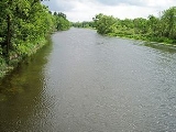
Long Prairie River
Encyclopedia
The Long Prairie River is a tributary
of the Crow Wing River
, 92 miles (148 km) long, in central Minnesota
in the United States
. Via the Crow Wing River, it is part of the watershed
of the Mississippi River
, draining an area of 892 square miles (2,310 km²) in a generally rural region.
by Europe
ans, the vicinity of the Long Prairie River was inhabited by the Dakota
and Ojibwa
. However, according to Schoolcraft
in 1832 the land about this river was uninhabited, being a boundary or war road between the Ojibwa and the Dakota. In the Chippewa treaties in 1847, the land on the west bank was ceded by the Pillager Chippewa as a homeland for the Menomini and the land on the east bank was ceded by the Lake Superior Chippewa
and the Mississippi Chippewa as a homeland for the Winnebago
s, in anticipation of Indian removal
out of Wisconsin
upon statehood. The Menomini
refused removal and never came to Minnesota, so the land was subsequently ceded to the United States. Many of the Winnebago
es were removed, but due to ongoing skirmishes between the Pillager Chippewa
and the Dakota Sioux
, the Winnebagoes were in constant danger, so they requested for relocation to southern Minnesota, near Mankato, and in 1855 ceded the land to the United States. Settlers had begun farming the region's prairies and clearing its timber by the 1860s.
The English name of the river, according to Gilfillan
, is derived from the Ojibwa Gaa-zhaagawashkodeyaa-ziibi, transliterated "Long-narrow-Prairie River."
The Lonq Prairie River played a vital role in the early settlement pattern of Todd County. History describes the Long Prairie River valley as a hunting ground for the Dakota
and Anishinaabe
/Ojibwa, with the river itself providing a transportation link with the Crow Wing
and Mississippi
.
Starting as early as the 1840s the river and its grass filled valley were where the settlers first established themselves. By the mid 1860s several settlements from the present site of Long Prairie to Motley were prospering, using flatboats, and for a very short time even a steam boat, for transportation and shipping. By 1877 the water level had fallen to a point that only very small water craft could navigate the river on a regular basis. In late 1877 H.D. Orendorf cut a road down the west side of the river from Turtle Creek to Motley. For many years this was the only road down the river valley.
Some of the villages that grew up along the 100 miles (160.9 km) length of the Long Prairie have prospered, some have disappeared completely. Hartford, on the banks of the river, opposite the mouth of Eagle Creek was settled in 1865 by John Bassett who was attracted to the area by the open grasslands north of the river. The railroad brought about the demise of Hartford when they built on the west side of the river, the community migrated to it and became what is now known as Browerville.
Long Prairie was never a river town like Hartford. In the 1840s it was settled as the administrative headquarters for carrying out the agreement between Washington DC and the Winnebago (now Ho-Chunk
) Indians. The settlement developed along Venewitz Creek and was said to be more populous than St Paul at that time. In 1855 the Winnebago
had been moved to a reservation in Blue Earth County
in southern Minnesota, and the lands were sold to investors from Ohio. The settlement was abandoned during the 1862 Dakota uprising
. The area slowly repopulated by settlers passing through the area who stayed, in many cases, because of the availability of the already constructed buildings and homes.
At the end of the Civil War
the communities west of Long Prairie were settled by Southern
soldiers who had fought for the Union Army that were not very welcome in their home state of Kentucky
. Once located at the present intersection of County Roads 38 and 11, Whiteville was settled by the three White sisters and their families. Clotho was settled where it is because, it seems, settlers couldn’t go any further given that the forests and swamps to the west were impenetrable.
At the time of Todd County
’s original European settlement, the forested areas of the Long Prairie River Watershed were substantial. The Marshner Pre-European Settlement Vegetation Map, shows 65.5% of the area was covered by a variety of hard woods and pines. The first commercial logging began about 1866 and continued through the mid 1890s. Eagle, Moran, Fish Trap, and Turtle creeks were all large enough, at that time, to power mills and float logs to the Long Prairie River where they joined other log rafts on their way to the Crow Wing and to the Mississippi. As most of the trees were harvested, the sandy soils in these areas were left unprotected, increasing the erosion, and gradually filling the streams with sediment. The result is the very much smaller streams we have today. The 1990’s Land Use map shows only 21% of the area forested, much restored due to reforestation plantings, and over 60% of the area as cultivated, hay, pasture or grassland.
As the Long Prairie River Watershed was settled, roads and railroads took over the job of transportation and shipping. Landowners used the river as a source of water for themselves, their livestock, and more recently, for irrigation. Industry located along the riverbanks and used the river as a source of water and as a discharge point for the waste materials generated by their companies. Few cities and villages used the river for drinking water, because the shallow sand aquifer along the river provided easy access to well water. Wastewater, however, was and still is discharged to the river and to Eagle Creek, one of the larger tributaries.
Early irrigation used mostly surface water sources, primarily the Long Prairie River. In the dry years of the late 1970s, many irrigation systems were shut down at critical times because of low surface water levels. This action prompted most Irrigators to change over to wells. To this day, irrigation systems are flourishing in the deep water rich sands of the Long Prairie River Valley, but by 1994, only 14 surface water permits still existed in Todd County.
of the Long Prairie River are in a region of numerous lakes north of Alexandria
. It issues from Lake Carlos in Carlos Township
in Douglas County
, just south of Lake Carlos State Park
and approximately seven miles north-northeast of Alexandria. Tributaries to Lake Carlos, which drain several lakes including Lake Darling, Lake Ida, Lake Miltona, and Geneva Lake, account for approximately a quarter of the Long Prairie River's watershed. The river initially flows eastwardly into Todd County
; ditch
es in its upper course connect the river to Lake Osakis
, which is the source of the Sauk River
, thereby joining the two rivers' watersheds during periods of high water. At the city of Long Prairie
the river turns north-northeastwardly, flowing past Browerville
and through a state wildlife management area, into northwestern Morrison County
, where it enters the Crow Wing River from the south in Motley Township
, about a mile (2 km) southeast of Motley
. Most of the river's watershed is within the North Central Hardwood Forest ecoregion
, which is characterized by hardwood
forests of maple
and basswood
mixed with conifers, on outwash plain
s and moraines amid flat glacial lake
s.
According to the Minnesota Pollution Control Agency, 41% of the Long Prairie River's watershed below Lake Carlos is used for agriculture; the main crops are potato
es, corn
, soybean
s and alfalfa
. Twenty-four percent of the watershed is grassland
including pasture
; 21% is forested; 10% is water or wetland
; and 3% is urban or developed. Because the river's floodplain
is wide and flat, land immediately adjacent to the river is predominately agricultural or wetland. Agricultural use is not dominant along the upper (eastward) course of the river, which was historically covered by aspen
and oak
forest, wetlands, and tallgrass prairie
; downstream of Browerville, farmland and second-growth forest
are interspersed.
The Minnesota Department of Natural Resources
has identified the Long Prairie River as a route for canoeing
. Fish
species in the river include northern pike
, walleye
, smallmouth bass
, and largemouth bass
.
's stream gauge
in the city of Long Prairie, the annual mean flow of the river between 1972 and 2005 was 166 cubic feet per second (5 m³/s). The highest recorded flow during the period was 3,270 ft³/s (93 m³/s) on July 22, 1972. The lowest recorded flow was 0.84 ft³/s (0 m³/s) on January 12, 1977.
Tributary
A tributary or affluent is a stream or river that flows into a main stem river or a lake. A tributary does not flow directly into a sea or ocean...
of the Crow Wing River
Crow Wing River
The Crow Wing River is a tributary of the Mississippi River approximately in length. The river arises in a chain of 11 lakes in southern Hubbard County, Minnesota and flows generally southeast, entering the Mississippi at Crow Wing State Park, northwest of Little Falls, Minnesota. Its name is a...
, 92 miles (148 km) long, in central Minnesota
Minnesota
Minnesota is a U.S. state located in the Midwestern United States. The twelfth largest state of the U.S., it is the twenty-first most populous, with 5.3 million residents. Minnesota was carved out of the eastern half of the Minnesota Territory and admitted to the Union as the thirty-second state...
in the United States
United States
The United States of America is a federal constitutional republic comprising fifty states and a federal district...
. Via the Crow Wing River, it is part of the watershed
Drainage basin
A drainage basin is an extent or an area of land where surface water from rain and melting snow or ice converges to a single point, usually the exit of the basin, where the waters join another waterbody, such as a river, lake, reservoir, estuary, wetland, sea, or ocean...
of the Mississippi River
Mississippi River
The Mississippi River is the largest river system in North America. Flowing entirely in the United States, this river rises in western Minnesota and meanders slowly southwards for to the Mississippi River Delta at the Gulf of Mexico. With its many tributaries, the Mississippi's watershed drains...
, draining an area of 892 square miles (2,310 km²) in a generally rural region.
History
Prior to settlementSettler
A settler is a person who has migrated to an area and established permanent residence there, often to colonize the area. Settlers are generally people who take up residence on land and cultivate it, as opposed to nomads...
by Europe
Europe
Europe is, by convention, one of the world's seven continents. Comprising the westernmost peninsula of Eurasia, Europe is generally 'divided' from Asia to its east by the watershed divides of the Ural and Caucasus Mountains, the Ural River, the Caspian and Black Seas, and the waterways connecting...
ans, the vicinity of the Long Prairie River was inhabited by the Dakota
Sioux
The Sioux are Native American and First Nations people in North America. The term can refer to any ethnic group within the Great Sioux Nation or any of the nation's many language dialects...
and Ojibwa
Ojibwa
The Ojibwe or Chippewa are among the largest groups of Native Americans–First Nations north of Mexico. They are divided between Canada and the United States. In Canada, they are the third-largest population among First Nations, surpassed only by Cree and Inuit...
. However, according to Schoolcraft
Henry Schoolcraft
Henry Rowe Schoolcraft was an American geographer, geologist, and ethnologist, noted for his early studies of Native American cultures, as well as for his 1832 discovery of the source of the Mississippi River. He married Jane Johnston, whose parents were Ojibwe and Scots-Irish...
in 1832 the land about this river was uninhabited, being a boundary or war road between the Ojibwa and the Dakota. In the Chippewa treaties in 1847, the land on the west bank was ceded by the Pillager Chippewa as a homeland for the Menomini and the land on the east bank was ceded by the Lake Superior Chippewa
Lake Superior Chippewa
The Lake Superior Chippewa were a historical band of Ojibwe Indians living around Lake Superior in what is now the northern parts of Michigan, Wisconsin, and Minnesota.-Origins:...
and the Mississippi Chippewa as a homeland for the Winnebago
Ho-Chunk
The Ho-Chunk, also known as Winnebago, are a tribe of Native Americans, native to what is now Wisconsin and Illinois. There are two federally recognized Ho-Chunk tribes, the Ho-Chunk Nation of Wisconsin and Winnebago Tribe of Nebraska....
s, in anticipation of Indian removal
Indian Removal
Indian removal was a nineteenth century policy of the government of the United States to relocate Native American tribes living east of the Mississippi River to lands west of the river...
out of Wisconsin
Wisconsin
Wisconsin is a U.S. state located in the north-central United States and is part of the Midwest. It is bordered by Minnesota to the west, Iowa to the southwest, Illinois to the south, Lake Michigan to the east, Michigan to the northeast, and Lake Superior to the north. Wisconsin's capital is...
upon statehood. The Menomini
Menominee
Some placenames use other spellings, see also Menomonee and Menomonie.The Menominee are a nation of Native Americans living in Wisconsin. The Menominee, along with the Ho-Chunk, are the only tribes that are indigenous to what is now Wisconsin...
refused removal and never came to Minnesota, so the land was subsequently ceded to the United States. Many of the Winnebago
Ho-Chunk
The Ho-Chunk, also known as Winnebago, are a tribe of Native Americans, native to what is now Wisconsin and Illinois. There are two federally recognized Ho-Chunk tribes, the Ho-Chunk Nation of Wisconsin and Winnebago Tribe of Nebraska....
es were removed, but due to ongoing skirmishes between the Pillager Chippewa
Pillager Band of Chippewa Indians
Pillager Band of Chippewa Indians are a historical band of Chippewa , originally living at the headwaters of the Mississippi River. Their name "Pillagers" is a translation of Makandwewininiwag, which literally means "Pillaging Men"...
and the Dakota Sioux
Sioux
The Sioux are Native American and First Nations people in North America. The term can refer to any ethnic group within the Great Sioux Nation or any of the nation's many language dialects...
, the Winnebagoes were in constant danger, so they requested for relocation to southern Minnesota, near Mankato, and in 1855 ceded the land to the United States. Settlers had begun farming the region's prairies and clearing its timber by the 1860s.
The English name of the river, according to Gilfillan
Joseph Gilfillan
Joseph Alexander Gilfillan was an Episcopal missionary to Native Americans of the Ojibwa Tribe on White Earth Reservation in northern Minnesota during 35 years from 1873 until 1908.-Biography:...
, is derived from the Ojibwa Gaa-zhaagawashkodeyaa-ziibi, transliterated "Long-narrow-Prairie River."
The Lonq Prairie River played a vital role in the early settlement pattern of Todd County. History describes the Long Prairie River valley as a hunting ground for the Dakota
Sioux
The Sioux are Native American and First Nations people in North America. The term can refer to any ethnic group within the Great Sioux Nation or any of the nation's many language dialects...
and Anishinaabe
Anishinaabe
Anishinaabe or Anishinabe—or more properly Anishinaabeg or Anishinabek, which is the plural form of the word—is the autonym often used by the Odawa, Ojibwe, and Algonquin peoples. They all speak closely related Anishinaabemowin/Anishinaabe languages, of the Algonquian language family.The meaning...
/Ojibwa, with the river itself providing a transportation link with the Crow Wing
Crow Wing River
The Crow Wing River is a tributary of the Mississippi River approximately in length. The river arises in a chain of 11 lakes in southern Hubbard County, Minnesota and flows generally southeast, entering the Mississippi at Crow Wing State Park, northwest of Little Falls, Minnesota. Its name is a...
and Mississippi
Mississippi River
The Mississippi River is the largest river system in North America. Flowing entirely in the United States, this river rises in western Minnesota and meanders slowly southwards for to the Mississippi River Delta at the Gulf of Mexico. With its many tributaries, the Mississippi's watershed drains...
.
Starting as early as the 1840s the river and its grass filled valley were where the settlers first established themselves. By the mid 1860s several settlements from the present site of Long Prairie to Motley were prospering, using flatboats, and for a very short time even a steam boat, for transportation and shipping. By 1877 the water level had fallen to a point that only very small water craft could navigate the river on a regular basis. In late 1877 H.D. Orendorf cut a road down the west side of the river from Turtle Creek to Motley. For many years this was the only road down the river valley.
Some of the villages that grew up along the 100 miles (160.9 km) length of the Long Prairie have prospered, some have disappeared completely. Hartford, on the banks of the river, opposite the mouth of Eagle Creek was settled in 1865 by John Bassett who was attracted to the area by the open grasslands north of the river. The railroad brought about the demise of Hartford when they built on the west side of the river, the community migrated to it and became what is now known as Browerville.
Long Prairie was never a river town like Hartford. In the 1840s it was settled as the administrative headquarters for carrying out the agreement between Washington DC and the Winnebago (now Ho-Chunk
Ho-Chunk
The Ho-Chunk, also known as Winnebago, are a tribe of Native Americans, native to what is now Wisconsin and Illinois. There are two federally recognized Ho-Chunk tribes, the Ho-Chunk Nation of Wisconsin and Winnebago Tribe of Nebraska....
) Indians. The settlement developed along Venewitz Creek and was said to be more populous than St Paul at that time. In 1855 the Winnebago
Ho-Chunk
The Ho-Chunk, also known as Winnebago, are a tribe of Native Americans, native to what is now Wisconsin and Illinois. There are two federally recognized Ho-Chunk tribes, the Ho-Chunk Nation of Wisconsin and Winnebago Tribe of Nebraska....
had been moved to a reservation in Blue Earth County
Blue Earth County, Minnesota
Blue Earth County is a county located in the U.S. state of Minnesota. As of 2010, the population was 64,013. Its county seat is Mankato.Blue Earth County is part of the Mankato–North Mankato Metropolitan Statistical Area.-Geography:...
in southern Minnesota, and the lands were sold to investors from Ohio. The settlement was abandoned during the 1862 Dakota uprising
Dakota War of 1862
The Dakota War of 1862, also known as the Sioux Uprising, was an armed conflict between the United States and several bands of the eastern Sioux. It began on August 17, 1862, along the Minnesota River in southwest Minnesota...
. The area slowly repopulated by settlers passing through the area who stayed, in many cases, because of the availability of the already constructed buildings and homes.
At the end of the Civil War
American Civil War
The American Civil War was a civil war fought in the United States of America. In response to the election of Abraham Lincoln as President of the United States, 11 southern slave states declared their secession from the United States and formed the Confederate States of America ; the other 25...
the communities west of Long Prairie were settled by Southern
Southern United States
The Southern United States—commonly referred to as the American South, Dixie, or simply the South—constitutes a large distinctive area in the southeastern and south-central United States...
soldiers who had fought for the Union Army that were not very welcome in their home state of Kentucky
Kentucky
The Commonwealth of Kentucky is a state located in the East Central United States of America. As classified by the United States Census Bureau, Kentucky is a Southern state, more specifically in the East South Central region. Kentucky is one of four U.S. states constituted as a commonwealth...
. Once located at the present intersection of County Roads 38 and 11, Whiteville was settled by the three White sisters and their families. Clotho was settled where it is because, it seems, settlers couldn’t go any further given that the forests and swamps to the west were impenetrable.
At the time of Todd County
Todd County, Minnesota
-External links:*...
’s original European settlement, the forested areas of the Long Prairie River Watershed were substantial. The Marshner Pre-European Settlement Vegetation Map, shows 65.5% of the area was covered by a variety of hard woods and pines. The first commercial logging began about 1866 and continued through the mid 1890s. Eagle, Moran, Fish Trap, and Turtle creeks were all large enough, at that time, to power mills and float logs to the Long Prairie River where they joined other log rafts on their way to the Crow Wing and to the Mississippi. As most of the trees were harvested, the sandy soils in these areas were left unprotected, increasing the erosion, and gradually filling the streams with sediment. The result is the very much smaller streams we have today. The 1990’s Land Use map shows only 21% of the area forested, much restored due to reforestation plantings, and over 60% of the area as cultivated, hay, pasture or grassland.
As the Long Prairie River Watershed was settled, roads and railroads took over the job of transportation and shipping. Landowners used the river as a source of water for themselves, their livestock, and more recently, for irrigation. Industry located along the riverbanks and used the river as a source of water and as a discharge point for the waste materials generated by their companies. Few cities and villages used the river for drinking water, because the shallow sand aquifer along the river provided easy access to well water. Wastewater, however, was and still is discharged to the river and to Eagle Creek, one of the larger tributaries.
Early irrigation used mostly surface water sources, primarily the Long Prairie River. In the dry years of the late 1970s, many irrigation systems were shut down at critical times because of low surface water levels. This action prompted most Irrigators to change over to wells. To this day, irrigation systems are flourishing in the deep water rich sands of the Long Prairie River Valley, but by 1994, only 14 surface water permits still existed in Todd County.
Geography
The headwatersSource (river or stream)
The source or headwaters of a river or stream is the place from which the water in the river or stream originates.-Definition:There is no universally agreed upon definition for determining a stream's source...
of the Long Prairie River are in a region of numerous lakes north of Alexandria
Alexandria, Minnesota
As of the census of 2000, there were 8,820 people, however the most recent count suggests a population upwards of 10,000, which is displayed on Alexandria's city limits signs. The census lists 4,047 households, and 2,011 families residing in the city. The population density was 992.5 people per...
. It issues from Lake Carlos in Carlos Township
Carlos Township, Minnesota
Carlos Township is a township in Douglas County, Minnesota, United States. The population was 1,912 at the 2000 census.-Geography:According to the United States Census Bureau, the township has a total area of , of which, of it is land and of it is water.-Demographics:As of the census of 2000,...
in Douglas County
Douglas County, Minnesota
As of the census of 2000, there were 32,821 people, 13,276 households, and 9,027 families residing in the county. The population density was 52 people per square mile . There were 16,694 housing units at an average density of 26 per square mile...
, just south of Lake Carlos State Park
Lake Carlos State Park
Lake Carlos State Park is a state park about 10 miles north of Alexandria, Minnesota. The park was established in 1937 to provide a public recreational facility in one of Minnesota's summer resort centers, and attracts tourists from Minnesota and surrounding states.Five buildings in the park,...
and approximately seven miles north-northeast of Alexandria. Tributaries to Lake Carlos, which drain several lakes including Lake Darling, Lake Ida, Lake Miltona, and Geneva Lake, account for approximately a quarter of the Long Prairie River's watershed. The river initially flows eastwardly into Todd County
Todd County, Minnesota
-External links:*...
; ditch
Ditch
A ditch is usually defined as a small to moderate depression created to channel water.In Anglo-Saxon, the word dïc already existed and was pronounced 'deek' in northern England and 'deetch' in the south. The origins of the word lie in digging a trench and forming the upcast soil into a bank...
es in its upper course connect the river to Lake Osakis
Lake Osakis
Lake Osakis is a lake in Todd and Douglas counties in west-central Minnesota. The town of Osakis is situated on the southwest shore of the lake.-Name:...
, which is the source of the Sauk River
Sauk River (Minnesota)
The Sauk River is a tributary of the Mississippi River, approximately 90 mi long in central Minnesota in the United States. It drains small lakes in Stearns County...
, thereby joining the two rivers' watersheds during periods of high water. At the city of Long Prairie
Long Prairie, Minnesota
At the 2000 census, there were 3,040 people, 1,229 households and 769 families residing in the city. The population density was 1,285.2 per square mile . There were 1,334 housing units at an average density of 564.0 per square mile...
the river turns north-northeastwardly, flowing past Browerville
Browerville, Minnesota
As of the census of 2000, there were 735 people, 318 households, and 181 families residing in the city. The population density was 1,052.5 people per square mile . There were 337 housing units at an average density of 482.6 per square mile...
and through a state wildlife management area, into northwestern Morrison County
Morrison County, Minnesota
-Demographics:As of the census of 2000, there were 31,712 people, 11,816 households, and 8,460 families residing in the county. The population density was 28 people per square mile . There were 13,870 housing units at an average density of 12 per square mile...
, where it enters the Crow Wing River from the south in Motley Township
Motley Township, Minnesota
Motley Township is a township in Morrison County, Minnesota, United States. The population was 205 at the 2000 census.-Geography:According to the United States Census Bureau, the township has a total area of 15.9 square miles , of which, 15.3 square miles of it is land and...
, about a mile (2 km) southeast of Motley
Motley, Minnesota
As of the census of 2000, there were 585 people, 258 households, and 167 families residing in the city. The population density was 442.7 people per square mile . There were 270 housing units at an average density of 204.3 per square mile...
. Most of the river's watershed is within the North Central Hardwood Forest ecoregion
Ecoregion
An ecoregion , sometimes called a bioregion, is an ecologically and geographically defined area that is smaller than an ecozone and larger than an ecosystem. Ecoregions cover relatively large areas of land or water, and contain characteristic, geographically distinct assemblages of natural...
, which is characterized by hardwood
Hardwood
Hardwood is wood from angiosperm trees . It may also be used for those trees themselves: these are usually broad-leaved; in temperate and boreal latitudes they are mostly deciduous, but in tropics and subtropics mostly evergreen.Hardwood contrasts with softwood...
forests of maple
Maple
Acer is a genus of trees or shrubs commonly known as maple.Maples are variously classified in a family of their own, the Aceraceae, or together with the Hippocastanaceae included in the family Sapindaceae. Modern classifications, including the Angiosperm Phylogeny Group system, favour inclusion in...
and basswood
Tilia
Tilia is a genus of about 30 species of trees native throughout most of the temperate Northern Hemisphere. The greatest species diversity is found in Asia, and the genus also occurs in Europe and eastern North America, but not western North America...
mixed with conifers, on outwash plain
Sandur
A sandur is a glacial outwash plain formed of sediments deposited by meltwater at the terminus of a glacier.- Formation :Sandar are found in glaciated areas, such as Svalbard, Kerguelen Islands, and Iceland...
s and moraines amid flat glacial lake
Glacial lake
A glacial lake is a lake with origins in a melted glacier. Near the end of the last glacial period, roughly 10,000 years ago, glaciers began to retreat. A retreating glacier often left behind large deposits of ice in hollows between drumlins or hills. As the ice age ended, these melted to create...
s.
According to the Minnesota Pollution Control Agency, 41% of the Long Prairie River's watershed below Lake Carlos is used for agriculture; the main crops are potato
Potato
The potato is a starchy, tuberous crop from the perennial Solanum tuberosum of the Solanaceae family . The word potato may refer to the plant itself as well as the edible tuber. In the region of the Andes, there are some other closely related cultivated potato species...
es, corn
Maize
Maize known in many English-speaking countries as corn or mielie/mealie, is a grain domesticated by indigenous peoples in Mesoamerica in prehistoric times. The leafy stalk produces ears which contain seeds called kernels. Though technically a grain, maize kernels are used in cooking as a vegetable...
, soybean
Soybean
The soybean or soya bean is a species of legume native to East Asia, widely grown for its edible bean which has numerous uses...
s and alfalfa
Alfalfa
Alfalfa is a flowering plant in the pea family Fabaceae cultivated as an important forage crop in the US, Canada, Argentina, France, Australia, the Middle East, South Africa, and many other countries. It is known as lucerne in the UK, France, Australia, South Africa and New Zealand, and known as...
. Twenty-four percent of the watershed is grassland
Grassland
Grasslands are areas where the vegetation is dominated by grasses and other herbaceous plants . However, sedge and rush families can also be found. Grasslands occur naturally on all continents except Antarctica...
including pasture
Pasture
Pasture is land used for grazing. Pasture lands in the narrow sense are enclosed tracts of farmland, grazed by domesticated livestock, such as horses, cattle, sheep or swine. The vegetation of tended pasture, forage, consists mainly of grasses, with an interspersion of legumes and other forbs...
; 21% is forested; 10% is water or wetland
Wetland
A wetland is an area of land whose soil is saturated with water either permanently or seasonally. Wetlands are categorised by their characteristic vegetation, which is adapted to these unique soil conditions....
; and 3% is urban or developed. Because the river's floodplain
Floodplain
A floodplain, or flood plain, is a flat or nearly flat land adjacent a stream or river that stretches from the banks of its channel to the base of the enclosing valley walls and experiences flooding during periods of high discharge...
is wide and flat, land immediately adjacent to the river is predominately agricultural or wetland. Agricultural use is not dominant along the upper (eastward) course of the river, which was historically covered by aspen
Aspen
Populus section Populus, of the Populus genus, includes the aspen trees and the white poplar Populus alba. The five typical aspens are all native to cold regions with cool summers, in the north of the Northern Hemisphere, extending south at high altitudes in the mountains. The White Poplar, by...
and oak
Oak
An oak is a tree or shrub in the genus Quercus , of which about 600 species exist. "Oak" may also appear in the names of species in related genera, notably Lithocarpus...
forest, wetlands, and tallgrass prairie
Tallgrass prairie
The tallgrass prairie is an ecosystem native to central North America, with fire as its primary periodic disturbance. In the past, tallgrass prairies covered a large portion of the American Midwest, just east of the Great Plains, and portions of the Canadian Prairies. They flourished in areas with...
; downstream of Browerville, farmland and second-growth forest
Secondary forest
A secondary forest is a forest or woodland area which has re-grown after a major disturbance such as fire, insect infestation, timber harvest or windthrow, until a long enough period has passed so that the effects of the disturbance are no longer evident...
are interspersed.
The Minnesota Department of Natural Resources
Minnesota Department of Natural Resources
The Minnesota Department of Natural Resources is the agency of the U.S. state of Minnesota charged with conserving and managing the state's natural resources. The agency maintains areas such as state parks, state forests, recreational trails, and recreation areas as well as managing minerals,...
has identified the Long Prairie River as a route for canoeing
Canoeing
Canoeing is an outdoor activity that involves a special kind of canoe.Open canoes may be 'poled' , sailed, 'lined and tracked' or even 'gunnel-bobbed'....
. Fish
Fish
Fish are a paraphyletic group of organisms that consist of all gill-bearing aquatic vertebrate animals that lack limbs with digits. Included in this definition are the living hagfish, lampreys, and cartilaginous and bony fish, as well as various extinct related groups...
species in the river include northern pike
Northern Pike
The northern pike , is a species of carnivorous fish of the genus Esox...
, walleye
Walleye
Walleye is a freshwater perciform fish native to most of Canada and to the northern United States. It is a North American close relative of the European pikeperch...
, smallmouth bass
Smallmouth bass
The smallmouth bass is a species of freshwater fish in the sunfish family of the order Perciformes. It is the type species of its genus...
, and largemouth bass
Largemouth bass
The largemouth bass is a species of black bass in the sunfish family native to North America . It is also known as widemouth bass, bigmouth, black bass, bucketmouth, Potter's fish, Florida bass, Florida largemouth, green bass, green trout, linesides, Oswego bass, southern largemouth...
.
Flow rate
At the United States Geological SurveyUnited States Geological Survey
The United States Geological Survey is a scientific agency of the United States government. The scientists of the USGS study the landscape of the United States, its natural resources, and the natural hazards that threaten it. The organization has four major science disciplines, concerning biology,...
's stream gauge
Stream gauge
A stream gauge, stream gage or gauging station is a location used by hydrologists or environmental scientists to monitor and test terrestrial bodies of water. Hydrometric measurements of water surface elevation and/or volumetric discharge are generally taken and observations of biota may also be...
in the city of Long Prairie, the annual mean flow of the river between 1972 and 2005 was 166 cubic feet per second (5 m³/s). The highest recorded flow during the period was 3,270 ft³/s (93 m³/s) on July 22, 1972. The lowest recorded flow was 0.84 ft³/s (0 m³/s) on January 12, 1977.