

List of non-ecclesiastical works by Paley and Austin
Encyclopedia
Paley and Austin were the surnames of two architects working from a practice in Lancaster
, Lancashire
, England, between 1868 and 1886. The practice had been founded in 1836 by Edmund Sharpe
. The architects during the period covered by this list are E. G. Paley
and Hubert Austin
. E. G. Paley had joined Edmund Sharpe in partnership in 1845. This partnership continued until 1851, when Sharpe retired, and Paley ran the business as a single principal until he was joined by Hubert Austin in 1868. The partnership of Paley and Austin continued until they were joined as a partner by Paley's son, Henry Paley
, in 1886.
This list covers the non-ecclesiastical works executed by the practice during the partnership of Paley and Austin; the period from 1868 to 1886. These include new houses and alterations to houses (which varied in size from large country mansions to tenement blocks), railway stations, schools and alterations to schools, banks, industrial buildings, hospitals, and a bridge.Because of the location of the practice, most of their non-ecclesiastical work was in the areas that are now Cumbria
, Lancashire, and Greater Manchester
, but examples can also be found in Cheshire
, Yorkshire
, Merseyside
, County Durham
, Buckinghamshire
, and
Wales
.
Lancaster, Lancashire
Lancaster is the county town of Lancashire, England. It is situated on the River Lune and has a population of 45,952. Lancaster is a constituent settlement of the wider City of Lancaster, local government district which has a population of 133,914 and encompasses several outlying towns, including...
, Lancashire
Lancashire
Lancashire is a non-metropolitan county of historic origin in the North West of England. It takes its name from the city of Lancaster, and is sometimes known as the County of Lancaster. Although Lancaster is still considered to be the county town, Lancashire County Council is based in Preston...
, England, between 1868 and 1886. The practice had been founded in 1836 by Edmund Sharpe
Edmund Sharpe
Edmund Sharpe was an English architect and engineer. He started his career as an architect, initially on his own, then in partnership with Edward Paley, designing mainly churches but also some secular buildings...
. The architects during the period covered by this list are E. G. Paley
Edward Graham Paley
Edward Graham Paley, usually known as E. G. Paley, , was an English architect who practised in Lancaster, Lancashire, in the second half of the 19th century.-Education and career:...
and Hubert Austin
Hubert Austin
Hubert James Austin was an English architect who practiced in Lancaster. With his partners he designed many churches and other buildings, mainly in the northwest of England.-Early life and career:...
. E. G. Paley had joined Edmund Sharpe in partnership in 1845. This partnership continued until 1851, when Sharpe retired, and Paley ran the business as a single principal until he was joined by Hubert Austin in 1868. The partnership of Paley and Austin continued until they were joined as a partner by Paley's son, Henry Paley
Henry Paley
Henry Anderson Paley was an English architect, the only son of Edward Paley, also an architect, of Lancaster. He started his training with his father and Hubert Austin, then went on to the London office of T. E. Collcutt. He returned to his father's practice in 1882 and became a partner in 1886...
, in 1886.
This list covers the non-ecclesiastical works executed by the practice during the partnership of Paley and Austin; the period from 1868 to 1886. These include new houses and alterations to houses (which varied in size from large country mansions to tenement blocks), railway stations, schools and alterations to schools, banks, industrial buildings, hospitals, and a bridge.Because of the location of the practice, most of their non-ecclesiastical work was in the areas that are now Cumbria
Cumbria
Cumbria , is a non-metropolitan county in North West England. The county and Cumbria County Council, its local authority, came into existence in 1974 after the passage of the Local Government Act 1972. Cumbria's largest settlement and county town is Carlisle. It consists of six districts, and in...
, Lancashire, and Greater Manchester
Greater Manchester
Greater Manchester is a metropolitan county in North West England, with a population of 2.6 million. It encompasses one of the largest metropolitan areas in the United Kingdom and comprises ten metropolitan boroughs: Bolton, Bury, Oldham, Rochdale, Stockport, Tameside, Trafford, Wigan, and the...
, but examples can also be found in Cheshire
Cheshire
Cheshire is a ceremonial county in North West England. Cheshire's county town is the city of Chester, although its largest town is Warrington. Other major towns include Widnes, Congleton, Crewe, Ellesmere Port, Runcorn, Macclesfield, Winsford, Northwich, and Wilmslow...
, Yorkshire
Yorkshire
Yorkshire is a historic county of northern England and the largest in the United Kingdom. Because of its great size in comparison to other English counties, functions have been increasingly undertaken over time by its subdivisions, which have also been subject to periodic reform...
, Merseyside
Merseyside
Merseyside is a metropolitan county in North West England, with a population of 1,365,900. It encompasses the metropolitan area centred on both banks of the lower reaches of the Mersey Estuary, and comprises five metropolitan boroughs: Knowsley, St Helens, Sefton, Wirral, and the city of Liverpool...
, County Durham
County Durham
County Durham is a ceremonial county and unitary district in north east England. The county town is Durham. The largest settlement in the ceremonial county is the town of Darlington...
, Buckinghamshire
Buckinghamshire
Buckinghamshire is a ceremonial and non-metropolitan home county in South East England. The county town is Aylesbury, the largest town in the ceremonial county is Milton Keynes and largest town in the non-metropolitan county is High Wycombe....
, and
Wales
Wales
Wales is a country that is part of the United Kingdom and the island of Great Britain, bordered by England to its east and the Atlantic Ocean and Irish Sea to its west. It has a population of three million, and a total area of 20,779 km²...
.
Key
| Grade | Criteria | ||||||||||||
|---|---|---|---|---|---|---|---|---|---|---|---|---|---|
| Grade I | Buildings of exceptional interest, sometimes considered to be internationally important. | ||||||||||||
| Grade II* | Particularly important buildings of more than special interest. | ||||||||||||
| Grade II | Buildings of national importance and special interest. | ||||||||||||
| "—" denotes a work that is not graded. | |||||||||||||
Works
| Name | Location | Photograph | Date | Notes | Grade |
|---|---|---|---|---|---|
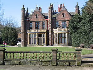
| Hoghton Tower Hoghton Tower Hoghton Tower is fortified manor house near the village of Hoghton in the Borough of Chorley to the east of Preston in Lancashire, England. It has been the ancestral home of the De Hoghton family since the time of William the Conqueror. It features a mile long driveway to the main gates... |
Hoghton Hoghton Hoghton is a small village and civil parish of the Borough of Chorley in Lancashire, England. According to the United Kingdom Census 2001 it has a population of 867... , Lancashire Lancashire Lancashire is a non-metropolitan county of historic origin in the North West of England. It takes its name from the city of Lancaster, and is sometimes known as the County of Lancaster. Although Lancaster is still considered to be the county town, Lancashire County Council is based in Preston... 53.7329°N 2.5737°W |
 |
After 1862 | Restoration. | I |
| Kents Bank railway station Kents Bank railway station Kents Bank railway station is a railway station that serves the village of Kents Bank in Cumbria. It is located on the Furness Line from Barrow-in-Furness to Lancaster.... |
Kents Bank Kents Bank Kents Bank is a small village in Cumbria, so named due to its proximity to the River Kent estuary.Part of the historic County Palatine of Lancashire, it is located two miles south-west of Grange-over-Sands... , Cumbria Cumbria Cumbria , is a non-metropolitan county in North West England. The county and Cumbria County Council, its local authority, came into existence in 1974 after the passage of the Local Government Act 1972. Cumbria's largest settlement and county town is Carlisle. It consists of six districts, and in... 54.1729°N 2.9254°W |
1865 | Built for the Furness Railway Furness Railway The Furness Railway was a railway company operating in the Furness area of Lancashire in North West England.-History:The company was established on May 23, 1844 when the Furness Railway Act was passed by Parliament... . |
||
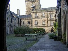
| Giggleswick School Giggleswick School Giggleswick School is an independent co-educational boarding school in Giggleswick, near Settle, North Yorkshire, England.- Early school :... |
Giggleswick Giggleswick Giggleswick is a village and civil parish in the Craven district of North Yorkshire, England near the town of Settle. It is the site of Giggleswick School.-Origin of name:A Dictionary of British Place Names contains the entry:... , North Yorkshire North Yorkshire North Yorkshire is a non-metropolitan or shire county located in the Yorkshire and the Humber region of England, and a ceremonial county primarily in that region but partly in North East England. Created in 1974 by the Local Government Act 1972 it covers an area of , making it the largest... 54.0728°N 2.2939°W |
1867–69 | Boarding house. | II | |
| Town Hall | St John's Chapel St John's Chapel, County Durham St John's Chapel is a village in County Durham, in England. It is situated in Weardale, on the south side of the River Wear on the A689 road between Daddry Shield and Ireshopeburn. The 2001 census reports a population of 307, of which only 43 are children under 16... , County Durham County Durham County Durham is a ceremonial county and unitary district in north east England. The county town is Durham. The largest settlement in the ceremonial county is the town of Darlington... 54.737°N 2.181°W |
1868 | |||
| Sedgwick House | Sedgwick Sedgwick, Cumbria Sedgwick is a village and civil parish in Cumbria, England, south of Kendal. Its main point of interest is Sedgwick House, built in 1868 by... , Cumbria Cumbria Cumbria , is a non-metropolitan county in North West England. The county and Cumbria County Council, its local authority, came into existence in 1974 after the passage of the Local Government Act 1972. Cumbria's largest settlement and county town is Carlisle. It consists of six districts, and in... 54.2765°N 2.7538°W |
1868–69 | New house in Perpendicular style; now a school. | II | |
| Bank, 68 Church Street | Lancaster Lancaster, Lancashire Lancaster is the county town of Lancashire, England. It is situated on the River Lune and has a population of 45,952. Lancaster is a constituent settlement of the wider City of Lancaster, local government district which has a population of 133,914 and encompasses several outlying towns, including... , Lancashire Lancashire Lancashire is a non-metropolitan county of historic origin in the North West of England. It takes its name from the city of Lancaster, and is sometimes known as the County of Lancaster. Although Lancaster is still considered to be the county town, Lancashire County Council is based in Preston... 54.0500°N 2.8018°W |
1870 | New bank for the Lancaster Banking Company; now National Westminster Bank National Westminster Bank National Westminster Bank Plc, commonly known as NatWest, is the largest retail and commercial bank in the United Kingdom and has been part of The Royal Bank of Scotland Group Plc since 2000. The Royal Bank of Scotland Group is ranked as the second largest bank in the world by assets... . |
II* | |
| Walton Hall Walton Hall, Cheshire Walton Hall is a country house in Walton, Warrington, Cheshire, England. It has been designated by English Heritage as a Grade II listed building. The hall and its surrounding garden and grounds are owned and administered by Warrington Borough Council.... |
Walton Walton, Cheshire Walton is a civil parish within the borough of Warrington in Cheshire, northern England.Walton is at the southwest edge of the borough, next to the parish of Stockton Heath. It is also close to Daresbury and Moore, although these are in the neighbouring borough of Halton.Walton is divided into... , Warrington Warrington Warrington is a town, borough and unitary authority area of Cheshire, England. It stands on the banks of the River Mersey, which is tidal to the west of the weir at Howley. It lies 16 miles east of Liverpool, 19 miles west of Manchester and 8 miles south of St Helens... , Cheshire Cheshire Cheshire is a ceremonial county in North West England. Cheshire's county town is the city of Chester, although its largest town is Warrington. Other major towns include Widnes, Congleton, Crewe, Ellesmere Port, Runcorn, Macclesfield, Winsford, Northwich, and Wilmslow... 53.3599°N 2.6023°W |
 |
1870 | Additions and alterations. | II |
| School and school house | Winmarleigh, Lancashire Lancashire Lancashire is a non-metropolitan county of historic origin in the North West of England. It takes its name from the city of Lancaster, and is sometimes known as the County of Lancaster. Although Lancaster is still considered to be the county town, Lancashire County Council is based in Preston... |
1870 | |||
| Leighton Hall Leighton Hall, Lancashire Leighton Hall is an historic house to the west of Yealand Conyers, Lancashire, England . It is a Grade II* listed building.It was the seat of the 1642-1673 Middleton Baronetcy of George Middleton. The estate came into the possession of George Towneley of Towneley Hall in Burnley, through his... |
Yealand Conyers Yealand Conyers Yealand Conyers is a village and civil parish in the English county of Lancashire. It is in the City of Lancaster district.-Community:The community is included in the same district as Yealand Redmayne and is south of Beetham.-Geography:... , Lancashire Lancashire Lancashire is a non-metropolitan county of historic origin in the North West of England. It takes its name from the city of Lancaster, and is sometimes known as the County of Lancaster. Although Lancaster is still considered to be the county town, Lancashire County Council is based in Preston... 54.1630°N 2.7758°W |
1870 | Added west wing and built a higher tower. | II* | |
| Jute mill | Barrow-in-Furness Barrow-in-Furness Barrow-in-Furness is an industrial town and seaport which forms about half the territory of the wider Borough of Barrow-in-Furness in the county of Cumbria, England. It lies north of Liverpool, northwest of Manchester and southwest from the county town of Carlisle... , Cumbria Cumbria Cumbria , is a non-metropolitan county in North West England. The county and Cumbria County Council, its local authority, came into existence in 1974 after the passage of the Local Government Act 1972. Cumbria's largest settlement and county town is Carlisle. It consists of six districts, and in... |
1870–71 | |||
| Whittington Hall | Whittington Whittington, Lancashire Whittington is a small settlement and civil parish in Lancashire, England, forming part of a cluster of sites along the Lune valley, each with evidence of a motte - as with Melling and Arkholme... , Lancashire Lancashire Lancashire is a non-metropolitan county of historic origin in the North West of England. It takes its name from the city of Lancaster, and is sometimes known as the County of Lancaster. Although Lancaster is still considered to be the county town, Lancashire County Council is based in Preston... 54.1807°N 2.6201°W |
1870–90 | Addition and alterations, including a billiards room. | II* | |
| Winmarleigh Hall | Winmarleigh Winmarleigh Winmarleigh is a village and civil parish of the Borough of Wyre in Lancashire, England. The village, which is north-west of Garstang, has an agricultural college, and most of the land in the area is owned by the Duchy of Lancaster. This includes the local pub, the Patten Arms. It is home to the... , Lancashire Lancashire Lancashire is a non-metropolitan county of historic origin in the North West of England. It takes its name from the city of Lancaster, and is sometimes known as the County of Lancaster. Although Lancaster is still considered to be the county town, Lancashire County Council is based in Preston... 53.9208°N 2.8086°W |
1871 | For the 1st Baron Winmarleigh John Wilson-Patten, 1st Baron Winmarleigh John Wilson-Patten, 1st Baron Winmarleigh PC was a British Conservative politician.-Background and education:... in Jacobean Jacobean architecture The Jacobean style is the second phase of Renaissance architecture in England, following the Elizabethan style. It is named after King James I of England, with whose reign it is associated.-Characteristics:... style. |
||
| Shipworks | Barrow-in-Furness Barrow-in-Furness Barrow-in-Furness is an industrial town and seaport which forms about half the territory of the wider Borough of Barrow-in-Furness in the county of Cumbria, England. It lies north of Liverpool, northwest of Manchester and southwest from the county town of Carlisle... , Cumbria Cumbria Cumbria , is a non-metropolitan county in North West England. The county and Cumbria County Council, its local authority, came into existence in 1974 after the passage of the Local Government Act 1972. Cumbria's largest settlement and county town is Carlisle. It consists of six districts, and in... |
1871–72 | For Ashburner. | ||
| Militia Barracks Barracks Barracks are specialised buildings for permanent military accommodation; the word may apply to separate housing blocks or to complete complexes. Their main object is to separate soldiers from the civilian population and reinforce discipline, training and esprit de corps. They were sometimes called... |
South Road, Lancaster Lancaster, Lancashire Lancaster is the county town of Lancashire, England. It is situated on the River Lune and has a population of 45,952. Lancaster is a constituent settlement of the wider City of Lancaster, local government district which has a population of 133,914 and encompasses several outlying towns, including... , Lancashire Lancashire Lancashire is a non-metropolitan county of historic origin in the North West of England. It takes its name from the city of Lancaster, and is sometimes known as the County of Lancaster. Although Lancaster is still considered to be the county town, Lancashire County Council is based in Preston... 54.0444°N 2.7981°W |
1871–72 | Extension. Now used as offices. | II | |
| Villas | Cavendish Park, Barrow Island, Cumbria Cumbria Cumbria , is a non-metropolitan county in North West England. The county and Cumbria County Council, its local authority, came into existence in 1974 after the passage of the Local Government Act 1972. Cumbria's largest settlement and county town is Carlisle. It consists of six districts, and in... 54.1053°N 3.2276°W |
1872 | |||
| Grange-over-Sands railway station Grange-over-Sands railway station Grange-over-Sands railway station is a railway station that serves the town of Grange-over-Sands in Cumbria. It is located on the Furness Line from Barrow-in-Furness to Lancaster. It is operated by First TransPennine Express.... |
Grange-over-Sands Grange-over-Sands Grange-over-Sands is a town and civil parish by the sea – with a wide tidal range, hence the "sands" name – in Cumbria, England. Historically, Grange-over-Sands was part of the County of Lancashire until 1974, when Cumbria was created under Local Government re-organisation which absorbed the area... , Cumbria Cumbria Cumbria , is a non-metropolitan county in North West England. The county and Cumbria County Council, its local authority, came into existence in 1974 after the passage of the Local Government Act 1972. Cumbria's largest settlement and county town is Carlisle. It consists of six districts, and in... 54.1957°N 2.9028°W |
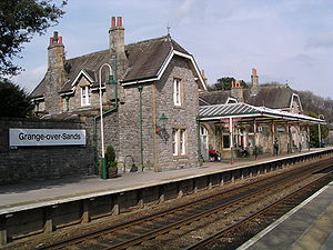 |
1872 | Station rebuilt. | II |
| Tenement block including mission and public house | Michaelson Street, Barrow Island, Cumbria Cumbria Cumbria , is a non-metropolitan county in North West England. The county and Cumbria County Council, its local authority, came into existence in 1974 after the passage of the Local Government Act 1972. Cumbria's largest settlement and county town is Carlisle. It consists of six districts, and in... 54.1046°N 3.2309°W |
1872–74 | II* | ||
| Ermysted's Grammar School Ermysted's Grammar School Ermysteds Grammar School is a LEA-funded selective boys' Grammar School in Skipton, North Yorkshire, England, teaching over 800 pupils.It is the seventh oldest state school in Britain and was founded by Peter Toller in the 15th century. The first official record of the school was seen in Peter... |
Skipton Skipton Skipton is a market town and civil parish within the Craven district of North Yorkshire, England. It is located along the course of both the Leeds and Liverpool Canal and the River Aire, on the south side of the Yorkshire Dales, northwest of Bradford and west of York... , North Yorkshire North Yorkshire North Yorkshire is a non-metropolitan or shire county located in the Yorkshire and the Humber region of England, and a ceremonial county primarily in that region but partly in North East England. Created in 1974 by the Local Government Act 1972 it covers an area of , making it the largest... 53.9634°N 2.0227°W |
1872–74 | Grammar school Grammar school A grammar school is one of several different types of school in the history of education in the United Kingdom and some other English-speaking countries, originally a school teaching classical languages but more recently an academically-oriented secondary school.The original purpose of mediaeval... built on new site. |
II | |
| Ulverston railway station Ulverston railway station Ulverston railway station is a railway station that serves the town of Ulverston in Cumbria, England.It is located on the Furness Line from Barrow-in-Furness to Lancaster. It is operated by First TransPennine Express.... |
Ulverston Ulverston Ulverston is a market town and civil parish in the South Lakeland district of Cumbria in north-west England. Historically part of Lancashire, the town is located in the Furness area, close to the Lake District, and just north of Morecambe Bay.... , Cumbria Cumbria Cumbria , is a non-metropolitan county in North West England. The county and Cumbria County Council, its local authority, came into existence in 1974 after the passage of the Local Government Act 1972. Cumbria's largest settlement and county town is Carlisle. It consists of six districts, and in... 54.1917°N 3.0976°W |
1872–74 | For the Furness Railway Furness Railway The Furness Railway was a railway company operating in the Furness area of Lancashire in North West England.-History:The company was established on May 23, 1844 when the Furness Railway Act was passed by Parliament... . |
||
| Bank | Ramsden Square, Barrow-in-Furness Barrow-in-Furness Barrow-in-Furness is an industrial town and seaport which forms about half the territory of the wider Borough of Barrow-in-Furness in the county of Cumbria, England. It lies north of Liverpool, northwest of Manchester and southwest from the county town of Carlisle... , Cumbria Cumbria Cumbria , is a non-metropolitan county in North West England. The county and Cumbria County Council, its local authority, came into existence in 1974 after the passage of the Local Government Act 1972. Cumbria's largest settlement and county town is Carlisle. It consists of six districts, and in... 54.1137°N 3.2313°W |
1873 | For the Cumberland Banking Company. Now offices. | II | |
| Bootle railway station Bootle railway station Bootle Railway Station, situated in the hamlet of Bootle Station, serves the village of Bootle and the neighbouring hamlet of Hycemoor in Cumbria, England. The railway station is a request stop on the scenic Cumbrian Coast Line north of Barrow-in-Furness... |
Bootle Bootle, Cumbria Bootle is a village and civil parish in the Borough of Copeland in Cumbria, England. According to the 2001 census, it had a population of 745. Historically within Cumberland, the village is in the Lake District National Park, and is close to the Irish Sea coast... , Cumbria Cumbria Cumbria , is a non-metropolitan county in North West England. The county and Cumbria County Council, its local authority, came into existence in 1974 after the passage of the Local Government Act 1972. Cumbria's largest settlement and county town is Carlisle. It consists of six districts, and in... 54.2913°N 3.3938°W |
 |
1873 | ||
| Holker Hall Holker Hall Holker Hall is a country house with a celebrated garden situated on the Cartmel Peninsula, which was historically part of the county of Lancashire, but is now part of the county of Cumbria.... |
Holker, Cumbria Cumbria Cumbria , is a non-metropolitan county in North West England. The county and Cumbria County Council, its local authority, came into existence in 1974 after the passage of the Local Government Act 1972. Cumbria's largest settlement and county town is Carlisle. It consists of six districts, and in... 54.1884°N 2.9837°W |
1873 | New west wing in Elizabethan Elizabethan architecture Elizabethan architecture is the term given to early Renaissance architecture in England, during the reign of Queen Elizabeth I. Historically, the period corresponds to the Cinquecento in Italy, the Early Renaissance in France, and the Plateresque style in Spain... style. |
II* | |
| Vicarage | Rose Lane, Mossley Hill Mossley Hill Mossley Hill is a district of Liverpool, Merseyside, England and a Liverpool City Council Ward. It is located to the south of the city, bordered by Aigburth, Wavertree, Childwall and Allerton. At the 2001 Census, the Mossley Hill ward had a population which was recorded at 12,650.-Notable... , Liverpool Liverpool Liverpool is a city and metropolitan borough of Merseyside, England, along the eastern side of the Mersey Estuary. It was founded as a borough in 1207 and was granted city status in 1880... , Merseyside Merseyside Merseyside is a metropolitan county in North West England, with a population of 1,365,900. It encompasses the metropolitan area centred on both banks of the lower reaches of the Mersey Estuary, and comprises five metropolitan boroughs: Knowsley, St Helens, Sefton, Wirral, and the city of Liverpool... 53.3767°N 2.9200°W |
1873 | Vicarage Rectory A rectory is the residence, or former residence, of a rector, most often a Christian cleric, but in some cases an academic rector or other person with that title... for the Church of St Matthew and St James Church of St Matthew and St James, Liverpool The Church of St Matthew and St James, Liverpool, stands on the top of a hill in Rose Lane, Mossley Hill, Liverpool, Merseyside, England. It is a Grade II* listed building and an active Anglican parish church in the deanery of Liverpool South Childwall, the archdeaconry of Liverpool and the... |
II | |
| Morecambe railway station | Morecambe Morecambe Morecambe is a resort town and civil parish within the City of Lancaster in Lancashire, England. As of 2001 it has a resident population of 38,917. It faces into Morecambe Bay... , Lancashire Lancashire Lancashire is a non-metropolitan county of historic origin in the North West of England. It takes its name from the city of Lancaster, and is sometimes known as the County of Lancaster. Although Lancaster is still considered to be the county town, Lancashire County Council is based in Preston... |
1873 | Built in Northumberland Street; some of its features removed and incorporated in Morecambe Promenade railway station Morecambe Promenade railway station Morecambe Promenade Station was a railway station in Morecambe, Lancashire. It was opened on March 24th 1907 by the Midland Railway and closed in February 1994... when it was built in 1909 in Marine Road Central. |
||
| Bank | Ramsden Square, Barrow-in-Furness Barrow-in-Furness Barrow-in-Furness is an industrial town and seaport which forms about half the territory of the wider Borough of Barrow-in-Furness in the county of Cumbria, England. It lies north of Liverpool, northwest of Manchester and southwest from the county town of Carlisle... , Cumbria Cumbria Cumbria , is a non-metropolitan county in North West England. The county and Cumbria County Council, its local authority, came into existence in 1974 after the passage of the Local Government Act 1972. Cumbria's largest settlement and county town is Carlisle. It consists of six districts, and in... 54.1144°N 3.2311°W |
1873–74 | For the Lancaster Banking Company. Now the National Westminster Bank National Westminster Bank National Westminster Bank Plc, commonly known as NatWest, is the largest retail and commercial bank in the United Kingdom and has been part of The Royal Bank of Scotland Group Plc since 2000. The Royal Bank of Scotland Group is ranked as the second largest bank in the world by assets... . |
II | |
| Underley Hall | Kirkby Lonsdale Kirkby Lonsdale Kirkby Lonsdale is a small town and civil parish in the South Lakeland district of Cumbria, England, on the River Lune. Historically within Westmorland, it is situated south east of Kendal along the A65. The parish had a population of 1,771 recorded in the 2001 census.Notable buildings include St... , Cumbria Cumbria Cumbria , is a non-metropolitan county in North West England. The county and Cumbria County Council, its local authority, came into existence in 1974 after the passage of the Local Government Act 1972. Cumbria's largest settlement and county town is Carlisle. It consists of six districts, and in... 54.2157°N 2.5919°W |
1874 | Additions, including a new wing and tower; now a school. | II* | |
| School and school house | Bolton-by-Bowland Bolton-by-Bowland Bolton-by-Bowland is a village and civil parish in the Ribble Valley district of Lancashire, England. Prior to 1974, the village was part of Bowland Rural District in the West Riding of Yorkshire.... , Lancashire Lancashire Lancashire is a non-metropolitan county of historic origin in the North West of England. It takes its name from the city of Lancaster, and is sometimes known as the County of Lancaster. Although Lancaster is still considered to be the county town, Lancashire County Council is based in Preston... |
1874 | II | ||
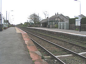
| Millom railway station Millom railway station Millom Railway Station serves the town of Millom in Cumbria, England. The railway station is a stop on the scenic Cumbrian Coast Line north of Barrow-in-Furness... |
Millom Millom Millom is a town and civil parish on the estuary of the River Duddon in the southwest of Cumbria, England. The name is Cumbrian dialect for "At the mills". The town is accessible both by rail and an A class road... , Cumbria Cumbria Cumbria , is a non-metropolitan county in North West England. The county and Cumbria County Council, its local authority, came into existence in 1974 after the passage of the Local Government Act 1972. Cumbria's largest settlement and county town is Carlisle. It consists of six districts, and in... 54.2110°N 3.2706°W |
 |
1874 | ||
| Oak Lea | Barrow-in-Furness Barrow-in-Furness Barrow-in-Furness is an industrial town and seaport which forms about half the territory of the wider Borough of Barrow-in-Furness in the county of Cumbria, England. It lies north of Liverpool, northwest of Manchester and southwest from the county town of Carlisle... , Cumbria Cumbria Cumbria , is a non-metropolitan county in North West England. The county and Cumbria County Council, its local authority, came into existence in 1974 after the passage of the Local Government Act 1972. Cumbria's largest settlement and county town is Carlisle. It consists of six districts, and in... |
1874 | New house for Mr Schneider; demolished 1913 (other than the Gate Lodge and the Coach House). | ||
| Witherslack Hall | Witherslack Witherslack Witherslack is a small village and civil parish in the south of Cumbria. It lies on the north eastern side of Morecambe Bay, England. The eastern side of the village borders Whitbarrow Scar with Yewbarrow, which is a small limestone hill, located in the centre of the villageWitherslack is quite... , Cumbria Cumbria Cumbria , is a non-metropolitan county in North West England. The county and Cumbria County Council, its local authority, came into existence in 1974 after the passage of the Local Government Act 1972. Cumbria's largest settlement and county town is Carlisle. It consists of six districts, and in... 54.2679°N 2.8671°W |
1874 | New house. | II | |
| Pilot cottages | Piel Island Piel Island Piel Island lies half a mile off the southern tip of the Furness Peninsula in the administrative county of Cumbria, though historically within Lancashire north of the sands. It is located at . It is one of the Islands of Furness in Northern England... , Cumbria Cumbria Cumbria , is a non-metropolitan county in North West England. The county and Cumbria County Council, its local authority, came into existence in 1974 after the passage of the Local Government Act 1972. Cumbria's largest settlement and county town is Carlisle. It consists of six districts, and in... 54.0652°N 3.1747°W |
1875 | |||
| Cark railway station | Cark Cark Cark is a village in Cumbria, England. It lies on the B5278 road to Haverthwaite and is ½ mile north of Flookburgh, 2 miles southwest of Cartmel and 3 miles west of Grange-over-Sands.... , Cumbria Cumbria Cumbria , is a non-metropolitan county in North West England. The county and Cumbria County Council, its local authority, came into existence in 1974 after the passage of the Local Government Act 1972. Cumbria's largest settlement and county town is Carlisle. It consists of six districts, and in... |
1875 | |||
| Schools | Cambridge Street, Barrow-in-Furness Barrow-in-Furness Barrow-in-Furness is an industrial town and seaport which forms about half the territory of the wider Borough of Barrow-in-Furness in the county of Cumbria, England. It lies north of Liverpool, northwest of Manchester and southwest from the county town of Carlisle... , Cumbria Cumbria Cumbria , is a non-metropolitan county in North West England. The county and Cumbria County Council, its local authority, came into existence in 1974 after the passage of the Local Government Act 1972. Cumbria's largest settlement and county town is Carlisle. It consists of six districts, and in... |
1875, with additions in ?1880. | |||
| Kirkby-in-Furness railway station Kirkby-in-Furness railway station Kirkby-in-Furness railway station serves the village of Kirkby-in-Furness in Cumbria, England. The railway station is a request stop on the scenic Cumbrian Coast Line. Some through trains to the Furness Line stop here. It is operated by Northern Rail who provide all passenger train services.The... |
Kirkby-in-Furness Kirkby-in-Furness Kirkby-in-Furness is a village in the Furness area of Cumbria, England. It is about 5 km south of Broughton in Furness and 8 km northwest of Ulverston. It is one of the largest villages on the peninsula's north-western coast, looking out over the Duddon estuary and the mountains of the... , Cumbria Cumbria Cumbria , is a non-metropolitan county in North West England. The county and Cumbria County Council, its local authority, came into existence in 1974 after the passage of the Local Government Act 1972. Cumbria's largest settlement and county town is Carlisle. It consists of six districts, and in... 54.2325°N 3.1875°W |
1875 | Station for the Furness Railway Furness Railway The Furness Railway was a railway company operating in the Furness area of Lancashire in North West England.-History:The company was established on May 23, 1844 when the Furness Railway Act was passed by Parliament... , now demolished. |
||
| Tenement block | Michaelson Street, Barrow Island, Cumbria Cumbria Cumbria , is a non-metropolitan county in North West England. The county and Cumbria County Council, its local authority, came into existence in 1974 after the passage of the Local Government Act 1972. Cumbria's largest settlement and county town is Carlisle. It consists of six districts, and in... 54.1034°N 3.2318°W |
c. 1875 | II* | ||
| Capernwray Hall Capernwray Hall Capernwray Hall is a former country house situated 3 miles ENE of Carnforth, Lancashire, England, and is currently used as a Christian bible school and holiday centre. The house has been designated by English Heritage as a Grade II* listed building... |
Over Kellet, Lancaster Lancaster, Lancashire Lancaster is the county town of Lancashire, England. It is situated on the River Lune and has a population of 45,952. Lancaster is a constituent settlement of the wider City of Lancaster, local government district which has a population of 133,914 and encompasses several outlying towns, including... , Lancashire Lancashire Lancashire is a non-metropolitan county of historic origin in the North West of England. It takes its name from the city of Lancaster, and is sometimes known as the County of Lancaster. Although Lancaster is still considered to be the county town, Lancashire County Council is based in Preston... 54.1436°N 2.6959°W |
 |
1875–76 | Southeast block, including a billiard room, added to the hall. | II* |
| Sandside railway station Sandside railway station Sandside was a railway station situated on the Hincaster Branch of the Furness Railway. The following station was Heversham, which was the last on the branch before the line joined what is now known as the West Coast Main Line at Hincaster Junction, south of Oxenholme.A Furness Railway local... |
Sandside, Lancashire Lancashire Lancashire is a non-metropolitan county of historic origin in the North West of England. It takes its name from the city of Lancaster, and is sometimes known as the County of Lancaster. Although Lancaster is still considered to be the county town, Lancashire County Council is based in Preston... 54.2219°N 2.7968°W |
1876 | Station on the Furness Railway Furness Railway The Furness Railway was a railway company operating in the Furness area of Lancashire in North West England.-History:The company was established on May 23, 1844 when the Furness Railway Act was passed by Parliament... , now demolished. |
||
| Piel Castle Piel Castle Piel Castle also known as Fouldry Castle, is a castle situated on the south-eastern point of Piel Island, 1 km off the southern tip of the Furness Peninsula, protecting the deep water harbour of Barrow-in-Furness in north west England..... |
Piel Island Piel Island Piel Island lies half a mile off the southern tip of the Furness Peninsula in the administrative county of Cumbria, though historically within Lancashire north of the sands. It is located at . It is one of the Islands of Furness in Northern England... , Cumbria Cumbria Cumbria , is a non-metropolitan county in North West England. The county and Cumbria County Council, its local authority, came into existence in 1974 after the passage of the Local Government Act 1972. Cumbria's largest settlement and county town is Carlisle. It consists of six districts, and in... 54.0622°N 3.1734°W |
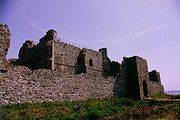 |
1876–78 | Restoration of the turret Turret In architecture, a turret is a small tower that projects vertically from the wall of a building such as a medieval castle. Turrets were used to provide a projecting defensive position allowing covering fire to the adjacent wall in the days of military fortification... and a staircase for the Duke of Buccleuch. |
I |
| Colliery schools | Whitehaven Whitehaven Whitehaven is a small town and port on the coast of Cumbria, England, which lies equidistant between the county's two largest settlements, Carlisle and Barrow-in-Furness, and is served by the Cumbrian Coast Line and the A595 road... , Cumbria Cumbria Cumbria , is a non-metropolitan county in North West England. The county and Cumbria County Council, its local authority, came into existence in 1974 after the passage of the Local Government Act 1972. Cumbria's largest settlement and county town is Carlisle. It consists of six districts, and in... |
1876 | |||
| Askham railway station | Askham Askham, Cumbria Askham is a village and civil parish in the Eden District of Cumbria, England. According to the 2001 census the parish had a population of 360. It is situated in the eastern edge of the Lake District National Park, about south of Penrith... , Cumbria Cumbria Cumbria , is a non-metropolitan county in North West England. The county and Cumbria County Council, its local authority, came into existence in 1974 after the passage of the Local Government Act 1972. Cumbria's largest settlement and county town is Carlisle. It consists of six districts, and in... |
1877 | |||
| Hydraulic Engine House | Ramsden Dock, Barrow-in-Furness Barrow-in-Furness Barrow-in-Furness is an industrial town and seaport which forms about half the territory of the wider Borough of Barrow-in-Furness in the county of Cumbria, England. It lies north of Liverpool, northwest of Manchester and southwest from the county town of Carlisle... , Cumbria Cumbria Cumbria , is a non-metropolitan county in North West England. The county and Cumbria County Council, its local authority, came into existence in 1974 after the passage of the Local Government Act 1972. Cumbria's largest settlement and county town is Carlisle. It consists of six districts, and in... |
1877 | |||
| Seascale railway station Seascale railway station Seascale railway station serves the village of Seascale in Cumbria, England. The railway station is on the Cumbrian Coast Line, and operated by Northern Rail who provide all passenger train services.... |
Seascale Seascale Seascale is a village and civil parish on the Irish Sea coast of Cumbria in north-west England.-History:The place-name indicates that it was inhabited by Norse settlers, probably before 1000 AD. It is derived from skali, meaning in Norse a wooden hut or shelter... , Cumbria Cumbria Cumbria , is a non-metropolitan county in North West England. The county and Cumbria County Council, its local authority, came into existence in 1974 after the passage of the Local Government Act 1972. Cumbria's largest settlement and county town is Carlisle. It consists of six districts, and in... 54.3961°N 3.4849°W |
1874 | |||
| Lancaster Royal Grammar School Lancaster Royal Grammar School Lancaster Royal Grammar School is a voluntary aided, selective grammar school for boys in Lancaster, England. The school has been awarded specialist Technology College and Language College status. Old boys belong to The Old Lancastrians... |
East Road, Lancaster Lancaster, Lancashire Lancaster is the county town of Lancashire, England. It is situated on the River Lune and has a population of 45,952. Lancaster is a constituent settlement of the wider City of Lancaster, local government district which has a population of 133,914 and encompasses several outlying towns, including... , Lancashire Lancashire Lancashire is a non-metropolitan county of historic origin in the North West of England. It takes its name from the city of Lancaster, and is sometimes known as the County of Lancaster. Although Lancaster is still considered to be the county town, Lancashire County Council is based in Preston... 54.0471°N 2.7901°W |
1. 1877 2. 1881 |
Extensions. | II | |
| Baths | Abbey Road, Barrow-in-Furness Barrow-in-Furness Barrow-in-Furness is an industrial town and seaport which forms about half the territory of the wider Borough of Barrow-in-Furness in the county of Cumbria, England. It lies north of Liverpool, northwest of Manchester and southwest from the county town of Carlisle... , Cumbria Cumbria Cumbria , is a non-metropolitan county in North West England. The county and Cumbria County Council, its local authority, came into existence in 1974 after the passage of the Local Government Act 1972. Cumbria's largest settlement and county town is Carlisle. It consists of six districts, and in... |
1878 | Alterations. | II | |
| Sedbergh School Sedbergh School Sedbergh School is a boarding school in Sedbergh, Cumbria, for boys and girls aged 13 to 18. Nestled in the Howgill Fells, it is known for sporting sides, such as its Rugby Union 1st XV.-Background:... |
Sedbergh Sedbergh Sedbergh is a small town in Cumbria, England. It lies about east of Kendal and about north of Kirkby Lonsdale. The town sits just within the Yorkshire Dales National Park... , Cumbria Cumbria Cumbria , is a non-metropolitan county in North West England. The county and Cumbria County Council, its local authority, came into existence in 1974 after the passage of the Local Government Act 1972. Cumbria's largest settlement and county town is Carlisle. It consists of six districts, and in... 54.3207°N 2.5286°W |
1. 1878 2. 1879 |
School House in 1878 and Sedgwick House the following year. | II | |
| St Peter's vicarage and school | Scorton Scorton, Lancashire Scorton is a small village near the River Wyre, in the Wyre district of Lancashire, England. It is located north of Garstang. The name means "farmstead near a ditch or ravine"-Background:... , Lancashire Lancashire Lancashire is a non-metropolitan county of historic origin in the North West of England. It takes its name from the city of Lancaster, and is sometimes known as the County of Lancaster. Although Lancaster is still considered to be the county town, Lancashire County Council is based in Preston... 53.9318°N 2.7593°W |
1878–79 | In association with St Peter's Church. | ||
| Foxfield railway station Foxfield railway station Foxfield Railway Station serves the villages of Foxfield and Broughton-in-Furness in Cumbria, England. The railway station is a request stop on the scenic Cumbrian Coast Line. Some through trains to the Furness Line stop here... |
Foxfield Foxfield, Cumbria Foxfield is a village on the west coast of Cumbria, in the Furness district that was part of Lancashire from 1182 to 1974. It lies on the Duddon Estuary, just outside of the Lake District National Park, around ten miles to the north-east of Barrow-in-Furness and one mile out of Broughton-in-Furness... , Cumbria Cumbria Cumbria , is a non-metropolitan county in North West England. The county and Cumbria County Council, its local authority, came into existence in 1974 after the passage of the Local Government Act 1972. Cumbria's largest settlement and county town is Carlisle. It consists of six districts, and in... 54.2587°N 3.2160°W |
1879 | Enlarged station for the Furness Railway Furness Railway The Furness Railway was a railway company operating in the Furness area of Lancashire in North West England.-History:The company was established on May 23, 1844 when the Furness Railway Act was passed by Parliament... . |
||
| The Knoll | Westbourne Road, Lancaster Lancaster, Lancashire Lancaster is the county town of Lancashire, England. It is situated on the River Lune and has a population of 45,952. Lancaster is a constituent settlement of the wider City of Lancaster, local government district which has a population of 133,914 and encompasses several outlying towns, including... , Lancashire Lancashire Lancashire is a non-metropolitan county of historic origin in the North West of England. It takes its name from the city of Lancaster, and is sometimes known as the County of Lancaster. Although Lancaster is still considered to be the county town, Lancashire County Council is based in Preston... |
1879 | A house designed by Austin for himself. Now a resource centre. | II | |
| St Mary's School | Lancaster Lancaster, Lancashire Lancaster is the county town of Lancashire, England. It is situated on the River Lune and has a population of 45,952. Lancaster is a constituent settlement of the wider City of Lancaster, local government district which has a population of 133,914 and encompasses several outlying towns, including... , Lancashire Lancashire Lancashire is a non-metropolitan county of historic origin in the North West of England. It takes its name from the city of Lancaster, and is sometimes known as the County of Lancaster. Although Lancaster is still considered to be the county town, Lancashire County Council is based in Preston... |
1879–;80 | |||
| Hornby Castle Hornby Castle, Lancashire Hornby Castle is a country house, developed from a medieval castle, standing to the east of the village of Hornby in the Lune Valley, Lancashire, England. It occupies a position overlooking the village in a curve of the River Wenning... |
Hornby Hornby-with-Farleton Hornby-with-Farleton is a civil parish in the City of Lancaster in Lancashire, England. It had a population of 729 recorded in the 2001 census,. The parish is north east of Lancaster and consists of two villages: Hornby and Farleton, both on the A683 road... , Lancashire Lancashire Lancashire is a non-metropolitan county of historic origin in the North West of England. It takes its name from the city of Lancaster, and is sometimes known as the County of Lancaster. Although Lancaster is still considered to be the county town, Lancashire County Council is based in Preston... 54.1114°N 2.6323°W |
1879–82 | Additions to the west side. | I | |
| Thurland Castle | Tunstall Tunstall, Lancashire Tunstall is a village in north Lancashire, England . It is northeast of Lancaster on the A683 road between Lancaster and Kirkby Lonsdale. In the 2001 census the civil parish of Tunstall had a population of 105.... , Lancashire Lancashire Lancashire is a non-metropolitan county of historic origin in the North West of England. It takes its name from the city of Lancaster, and is sometimes known as the County of Lancaster. Although Lancaster is still considered to be the county town, Lancashire County Council is based in Preston... 54.1520°N 2.5978°W |
1879–88 | A castellated house which had been almost completely destroyed by a fire; virtually a new building, partly in Elizabethan Elizabethan architecture Elizabethan architecture is the term given to early Renaissance architecture in England, during the reign of Queen Elizabeth I. Historically, the period corresponds to the Cinquecento in Italy, the Early Renaissance in France, and the Plateresque style in Spain... style, partly Gothic English Gothic architecture English Gothic is the name of the architectural style that flourished in England from about 1180 until about 1520.-Introduction:As with the Gothic architecture of other parts of Europe, English Gothic is defined by its pointed arches, vaulted roofs, buttresses, large windows, and spires... . Now divided into apartment Apartment An apartment or flat is a self-contained housing unit that occupies only part of a building... s. |
||
| Newton Hall | Newton, Whittington Whittington, Lancashire Whittington is a small settlement and civil parish in Lancashire, England, forming part of a cluster of sites along the Lune valley, each with evidence of a motte - as with Melling and Arkholme... , Lancashire Lancashire Lancashire is a non-metropolitan county of historic origin in the North West of England. It takes its name from the city of Lancaster, and is sometimes known as the County of Lancaster. Although Lancaster is still considered to be the county town, Lancashire County Council is based in Preston... 54.1671°N 2.6192°W |
1880 | New house, rebuilt on the site of a previous house. | II | |
| All Souls School | Astley Bridge, Bolton Bolton Bolton is a town in Greater Manchester, in the North West of England. Close to the West Pennine Moors, it is north west of the city of Manchester. Bolton is surrounded by several smaller towns and villages which together form the Metropolitan Borough of Bolton, of which Bolton is the... , Greater Manchester Greater Manchester Greater Manchester is a metropolitan county in North West England, with a population of 2.6 million. It encompasses one of the largest metropolitan areas in the United Kingdom and comprises ten metropolitan boroughs: Bolton, Bury, Oldham, Rochdale, Stockport, Tameside, Trafford, Wigan, and the... 53.5938°N 2.4333°W |
1880–81 | New school, now a community centre. | II | |
| Royal Albert Hospital Royal Albert Hospital The former Royal Albert Hospital is located in Ashton Road, Lancaster, Lancashire, England. It opened in 1870 as an institution for the care and education of children with learning problems. By 1909 there were 662 children in residence. Following new legislation in 1913, adults were also... |
Lancaster Lancaster, Lancashire Lancaster is the county town of Lancashire, England. It is situated on the River Lune and has a population of 45,952. Lancaster is a constituent settlement of the wider City of Lancaster, local government district which has a population of 133,914 and encompasses several outlying towns, including... , Lancashire Lancashire Lancashire is a non-metropolitan county of historic origin in the North West of England. It takes its name from the city of Lancaster, and is sometimes known as the County of Lancaster. Although Lancaster is still considered to be the county town, Lancashire County Council is based in Preston... 54.0534°N 2.7752°W |
1880–83 | Additions to mental hospital. | II* | |
| Vicarage | Arnside Arnside Arnside is a village and civil parish in Cumbria, England. It faces the estuary of the River Kent on the north eastern corner of Morecambe Bay, within the Arnside and Silverdale Area of Outstanding Natural Beauty... , Cumbria Cumbria Cumbria , is a non-metropolitan county in North West England. The county and Cumbria County Council, its local authority, came into existence in 1974 after the passage of the Local Government Act 1972. Cumbria's largest settlement and county town is Carlisle. It consists of six districts, and in... |
1881 | |||
| Bridge | Caton Caton, Lancashire The civil parish of Caton with Littledale is situated in Lancashire, England near the River Lune. The parish lies within the Forest of Bowland Area of Outstanding Natural Beauty and contains the villages of Caton, Brookhouse, Caton Green, Littledale and Townend.-History:The original settlement of... , Lancashire Lancashire Lancashire is a non-metropolitan county of historic origin in the North West of England. It takes its name from the city of Lancaster, and is sometimes known as the County of Lancaster. Although Lancaster is still considered to be the county town, Lancashire County Council is based in Preston... 54.0759°N 2.7316°W |
1881–83 | Road bridge over the River Lune River Lune The River Lune is a river in Cumbria and Lancashire, England.It is formed at Wath, in the parish of Ravenstonedale, Cumbria, at the confluence of Sandwath Beck and Weasdale Beck... . |
II | |
| Tenements | Steamer Street, Barrow Island, Cumbria Cumbria Cumbria , is a non-metropolitan county in North West England. The county and Cumbria County Council, its local authority, came into existence in 1974 after the passage of the Local Government Act 1972. Cumbria's largest settlement and county town is Carlisle. It consists of six districts, and in... 54.1036°N 3.2299°W |
1881–84 | II* | ||
| Tenements | Sloop Street, Barrow Island, Cumbria Cumbria Cumbria , is a non-metropolitan county in North West England. The county and Cumbria County Council, its local authority, came into existence in 1974 after the passage of the Local Government Act 1972. Cumbria's largest settlement and county town is Carlisle. It consists of six districts, and in... 54.1025°N 3.2308°W |
1881–84 | II* | ||
| Tenements | Brig Street, Barrow Island, Cumbria Cumbria Cumbria , is a non-metropolitan county in North West England. The county and Cumbria County Council, its local authority, came into existence in 1974 after the passage of the Local Government Act 1972. Cumbria's largest settlement and county town is Carlisle. It consists of six districts, and in... 54.1030°N 3.2300°W |
1881–84 | II | ||
| Tenements | Schooner Street, Barrow Island, Cumbria Cumbria Cumbria , is a non-metropolitan county in North West England. The county and Cumbria County Council, its local authority, came into existence in 1974 after the passage of the Local Government Act 1972. Cumbria's largest settlement and county town is Carlisle. It consists of six districts, and in... 54.1028°N 3.2295°W |
1881–84 | II | ||
| Tenements | Ship Street, Barrow Island, Cumbria Cumbria Cumbria , is a non-metropolitan county in North West England. The county and Cumbria County Council, its local authority, came into existence in 1974 after the passage of the Local Government Act 1972. Cumbria's largest settlement and county town is Carlisle. It consists of six districts, and in... 54.1033°N 3.2313°W |
1881–84 | II | ||
| Station and warehouse | Ramsden Dock, Barrow-in-Furness Barrow-in-Furness Barrow-in-Furness is an industrial town and seaport which forms about half the territory of the wider Borough of Barrow-in-Furness in the county of Cumbria, England. It lies north of Liverpool, northwest of Manchester and southwest from the county town of Carlisle... , Cumbria Cumbria Cumbria , is a non-metropolitan county in North West England. The county and Cumbria County Council, its local authority, came into existence in 1974 after the passage of the Local Government Act 1972. Cumbria's largest settlement and county town is Carlisle. It consists of six districts, and in... |
1882 | |||
| Coffee Hotel | Barrow Island, Cumbria Cumbria Cumbria , is a non-metropolitan county in North West England. The county and Cumbria County Council, its local authority, came into existence in 1974 after the passage of the Local Government Act 1972. Cumbria's largest settlement and county town is Carlisle. It consists of six districts, and in... |
1882 | |||
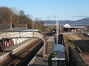
| Central railway station Barrow-in-Furness railway station Barrow-in-Furness railway station is a railway station that serves the town of Barrow-in-Furness in Cumbria, England. It is located on the Furness Line to Lancaster and the Cumbrian Coast Line to Workington and Carlisle... |
Barrow-in-Furness Barrow-in-Furness Barrow-in-Furness is an industrial town and seaport which forms about half the territory of the wider Borough of Barrow-in-Furness in the county of Cumbria, England. It lies north of Liverpool, northwest of Manchester and southwest from the county town of Carlisle... , Cumbria Cumbria Cumbria , is a non-metropolitan county in North West England. The county and Cumbria County Council, its local authority, came into existence in 1974 after the passage of the Local Government Act 1972. Cumbria's largest settlement and county town is Carlisle. It consists of six districts, and in... 54.1190°N 3.2260°W |
1882 | For the Furness Railway Furness Railway The Furness Railway was a railway company operating in the Furness area of Lancashire in North West England.-History:The company was established on May 23, 1844 when the Furness Railway Act was passed by Parliament... . Destroyed in the Second World War World War II World War II, or the Second World War , was a global conflict lasting from 1939 to 1945, involving most of the world's nations—including all of the great powers—eventually forming two opposing military alliances: the Allies and the Axis... . |
||
| Rylands House | Owen Road, Lancaster Lancaster, Lancashire Lancaster is the county town of Lancashire, England. It is situated on the River Lune and has a population of 45,952. Lancaster is a constituent settlement of the wider City of Lancaster, local government district which has a population of 133,914 and encompasses several outlying towns, including... , Lancashire Lancashire Lancashire is a non-metropolitan county of historic origin in the North West of England. It takes its name from the city of Lancaster, and is sometimes known as the County of Lancaster. Although Lancaster is still considered to be the county town, Lancashire County Council is based in Preston... |
1883 | Extensions. | II | |
| North Lonsdale Hospital | Barrow-in-Furness Barrow-in-Furness Barrow-in-Furness is an industrial town and seaport which forms about half the territory of the wider Borough of Barrow-in-Furness in the county of Cumbria, England. It lies north of Liverpool, northwest of Manchester and southwest from the county town of Carlisle... , Cumbria Cumbria Cumbria , is a non-metropolitan county in North West England. The county and Cumbria County Council, its local authority, came into existence in 1974 after the passage of the Local Government Act 1972. Cumbria's largest settlement and county town is Carlisle. It consists of six districts, and in... |
1883–87 | II | ||
| Masonic Hall | Abbey Road, Barrow-in-Furness Barrow-in-Furness Barrow-in-Furness is an industrial town and seaport which forms about half the territory of the wider Borough of Barrow-in-Furness in the county of Cumbria, England. It lies north of Liverpool, northwest of Manchester and southwest from the county town of Carlisle... , Cumbria Cumbria Cumbria , is a non-metropolitan county in North West England. The county and Cumbria County Council, its local authority, came into existence in 1974 after the passage of the Local Government Act 1972. Cumbria's largest settlement and county town is Carlisle. It consists of six districts, and in... |
1884 | |||
| Fawley Court Fawley Court Fawley Court is a country house standing on the banks of the River Thames at Fawley in the English county of Buckinghamshire, just north of Henley-on-Thames. The former deer park extended over the border into Oxfordshire... |
Fawley Fawley, Buckinghamshire Fawley is a village and civil parish in Wycombe district in the south-western corner of Buckinghamshire, England. It is on the boundary between Buckinghamshire and Oxfordshire, about seven miles west of Great Marlow and north of Henley-on-Thames.... , Buckinghamshire Buckinghamshire Buckinghamshire is a ceremonial and non-metropolitan home county in South East England. The county town is Aylesbury, the largest town in the ceremonial county is Milton Keynes and largest town in the non-metropolitan county is High Wycombe.... 51.5516°N 0.8979°W |
1884 | Addition of a new wing and terraces. Now a school. | I | |
| All Saints School | Higher Walton Higher Walton, Lancashire Higher Walton is a village in South Ribble, Lancashire, England. It is on the old road between Blackburn and Preston where it crosses the River Darwen. The road, at this point, is now part of the A675. Nearby places include Walton-le-Dale, Coupe Green, and Bamber Bridge.The main road through the... , Lancashire Lancashire Lancashire is a non-metropolitan county of historic origin in the North West of England. It takes its name from the city of Lancaster, and is sometimes known as the County of Lancaster. Although Lancaster is still considered to be the county town, Lancashire County Council is based in Preston... |
1884 | New school. | ||
| School House, St. Bees School St. Bees School St. Bees School is a co-educational independent school in the West Cumbrian village of St Bees. Founded in 1583 by the then Archbishop of Canterbury Edmund Grindal as a boys' "free grammar school", today it is a member of the Headmasters' and Headmistresses' Conference with around 300 pupils aged... |
St Bees St Bees St Bees is a village and civil parish in the Copeland district of Cumbria, in the North of England, about five miles west southwest of Whitehaven. The parish had a population of 1,717 according to the 2001 census. Within the parish is St... , Cumbria Cumbria Cumbria , is a non-metropolitan county in North West England. The county and Cumbria County Council, its local authority, came into existence in 1974 after the passage of the Local Government Act 1972. Cumbria's largest settlement and county town is Carlisle. It consists of six districts, and in... 54.4944°N 3.5925°W |
1885 | |||
| Home Farm and dairy | Whittington Whittington, Lancashire Whittington is a small settlement and civil parish in Lancashire, England, forming part of a cluster of sites along the Lune valley, each with evidence of a motte - as with Melling and Arkholme... , Lancashire Lancashire Lancashire is a non-metropolitan county of historic origin in the North West of England. It takes its name from the city of Lancaster, and is sometimes known as the County of Lancaster. Although Lancaster is still considered to be the county town, Lancashire County Council is based in Preston... |
1885 | Dairy and tea room added to farmhouse. | II | |
| St Barnabas' Vicarage | West Street, Crewe Crewe Crewe is a railway town within the unitary authority area of Cheshire East and the ceremonial county of Cheshire, England. According to the 2001 census the urban area had a population of 67,683... , Cheshire Cheshire Cheshire is a ceremonial county in North West England. Cheshire's county town is the city of Chester, although its largest town is Warrington. Other major towns include Widnes, Congleton, Crewe, Ellesmere Port, Runcorn, Macclesfield, Winsford, Northwich, and Wilmslow... 53.1021°N 2.4622°W |
c. 1885 | Vicarage Rectory A rectory is the residence, or former residence, of a rector, most often a Christian cleric, but in some cases an academic rector or other person with that title... for St Barbabas' Church. |
II | |
| Additional buildings, Ripley School |
Lancaster Lancaster, Lancashire Lancaster is the county town of Lancashire, England. It is situated on the River Lune and has a population of 45,952. Lancaster is a constituent settlement of the wider City of Lancaster, local government district which has a population of 133,914 and encompasses several outlying towns, including... , Lancashire Lancashire Lancashire is a non-metropolitan county of historic origin in the North West of England. It takes its name from the city of Lancaster, and is sometimes known as the County of Lancaster. Although Lancaster is still considered to be the county town, Lancashire County Council is based in Preston... 54.0393°N 2.8018°W |
1885–86 | II | ||
| St Barnabas' School | West Street, Crewe Crewe Crewe is a railway town within the unitary authority area of Cheshire East and the ceremonial county of Cheshire, England. According to the 2001 census the urban area had a population of 67,683... , Cheshire Cheshire Cheshire is a ceremonial county in North West England. Cheshire's county town is the city of Chester, although its largest town is Warrington. Other major towns include Widnes, Congleton, Crewe, Ellesmere Port, Runcorn, Macclesfield, Winsford, Northwich, and Wilmslow... 53.1020°N 2.4633°W |
1887 | |||
| Lodge, Whittington Hall | Whittington Whittington, Lancashire Whittington is a small settlement and civil parish in Lancashire, England, forming part of a cluster of sites along the Lune valley, each with evidence of a motte - as with Melling and Arkholme... , Lancashire Lancashire Lancashire is a non-metropolitan county of historic origin in the North West of England. It takes its name from the city of Lancaster, and is sometimes known as the County of Lancaster. Although Lancaster is still considered to be the county town, Lancashire County Council is based in Preston... 54.1814°N 2.6203°W |
1890 | Built as the north lodge to Whittington Hall. | II | |
| Dale Garth | Hawcoat Hawcoat Hawcoat is a ward of the UK town Barrow-in-Furness, Cumbria, North West England.The ward is one of the few places in Barrow that has been permanently inhabited since the middle ages; Hawcoat was named and identified as Hietun in the Domesday Book. It is the most northerly ward in Barrow and in 2001... , Barrow-in-Furness Barrow-in-Furness Barrow-in-Furness is an industrial town and seaport which forms about half the territory of the wider Borough of Barrow-in-Furness in the county of Cumbria, England. It lies north of Liverpool, northwest of Manchester and southwest from the county town of Carlisle... , Cumbria Cumbria Cumbria , is a non-metropolitan county in North West England. The county and Cumbria County Council, its local authority, came into existence in 1974 after the passage of the Local Government Act 1972. Cumbria's largest settlement and county town is Carlisle. It consists of six districts, and in... |
Undated | New house, now demolished. | ||
| Drigg railway station Drigg railway station Drigg railway station serves the villages of Drigg and Holmrook in Cumbria, England. The railway station is a request stop on the scenic Cumbrian Coast Line south of Whitehaven. Some through trains to the Furness Line stop here... |
Drigg Drigg Drigg is a village situated in the civil parish of Drigg and Carleton on the West Cumbria coast of the Irish Sea and on the boundary of the Lake District National Park in the county of Cumbria, England.... , Cumbria Cumbria Cumbria , is a non-metropolitan county in North West England. The county and Cumbria County Council, its local authority, came into existence in 1974 after the passage of the Local Government Act 1972. Cumbria's largest settlement and county town is Carlisle. It consists of six districts, and in... |
Undated | |||
| Llandovery College Llandovery College Llandovery College is an independent school in Llandovery, Carmarthenshire, Wales. It was founded and endowed by Thomas Phillips in 1847 to provide a classical and liberal education in which the Welsh language; the study of Welsh literature and history were also to be cultivated.Llandovery... |
Llandovery Llandovery Llandovery is a market town in Carmarthenshire, Wales, lying on the River Tywi and the A40 road.The town is served by Llandovery railway station, where there is a park and ride to Llanelli and Shrewsbury via the Heart of Wales Line... , Carmarthenshire Carmarthenshire Carmarthenshire is a unitary authority in the south west of Wales and one of thirteen historic counties. It is the 3rd largest in Wales. Its three largest towns are Llanelli, Carmarthen and Ammanford... , Wales Wales Wales is a country that is part of the United Kingdom and the island of Great Britain, bordered by England to its east and the Atlantic Ocean and Irish Sea to its west. It has a population of three million, and a total area of 20,779 km²... 51.9954°N 3.8005°W |
Undated | Additional buildings. | ||
| Ravenglass railway station | Ravenglass Ravenglass Ravenglass is a small coastal village and natural harbour in Cumbria, England. It is the only coastal town within the Lake District National Park... , Cumbria Cumbria Cumbria , is a non-metropolitan county in North West England. The county and Cumbria County Council, its local authority, came into existence in 1974 after the passage of the Local Government Act 1972. Cumbria's largest settlement and county town is Carlisle. It consists of six districts, and in... 54.3557°N 3.4089°W |
Undated | |||
| Chapel Ridding House | Windermere, Cumbria Cumbria Cumbria , is a non-metropolitan county in North West England. The county and Cumbria County Council, its local authority, came into existence in 1974 after the passage of the Local Government Act 1972. Cumbria's largest settlement and county town is Carlisle. It consists of six districts, and in... |
Undated | |||