
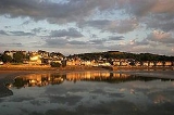
Arnside
Encyclopedia
Arnside is a village and civil parish in Cumbria
, England
. It faces the estuary of the River Kent
on the north eastern corner of Morecambe Bay
, within the Arnside and Silverdale Area of Outstanding Natural Beauty
. It lies within the historic county
of Westmorland
, near the border with Lancashire
, and has a population of 2,301.
The village lies on the railway line to West Cumbria, which passes over the River Kent via the Arnside viaduct. Up to the 19th century, the village had been used as a local port, but the building of the viaduct caused the estuary to silt up.
The oldest building in the parish is Arnside Tower
, a Peel tower
built in the 14th/15th century as a refuge against raids from Scots
and the Border Reivers
. The town is overlooked by Arnside Knott
, a hill
that rises out of the estuary.
, which serves the village, is located on the Furness Line
giving connections to Barrow-in-Furness
, Ulverston
, Grange-over-Sands
, Carnforth
and Lancaster
.
The line was opened in 1857 by the Ulverston and Lancaster Railway
, which was taken over by the Furness Railway
26 May 1862. The Furness Railway's Hincaster Branch
ran from 26 June 1876, connecting to the Lancaster and Carlisle Railway
at Hincaster
, which is now part of the West Coast Main Line
(WCML). Passenger services ended on the branch on 4 May 1942 and the lines were removed in 1966.
There are a few bus services which run through the village including the 552 and 553.
With each high tide Arnside is subjected to a very fast rising tide. Because of the potential danger warning notices are posted at the pier, and an audible warning is sounded before every high tide (in daylight). The sequence of warnings is:-
The cause of this fast tide is a combination of the large area of Morecambe Bay
, narrowing rapidly at Arnside, plus the second highest tidal range
(at Barrow-in-Furness
, which can be as much as 32 feet (9.8 m) on a spring tide nearest the Spring and Autumn equinox
: these typically give rise to a tidal bore
, which may be as high as 12 inches (30.5 cm), and are often used by canoeists.
Cumbria
Cumbria , is a non-metropolitan county in North West England. The county and Cumbria County Council, its local authority, came into existence in 1974 after the passage of the Local Government Act 1972. Cumbria's largest settlement and county town is Carlisle. It consists of six districts, and in...
, England
England
England is a country that is part of the United Kingdom. It shares land borders with Scotland to the north and Wales to the west; the Irish Sea is to the north west, the Celtic Sea to the south west, with the North Sea to the east and the English Channel to the south separating it from continental...
. It faces the estuary of the River Kent
River Kent
The River Kent is a short river in the county of Cumbria in England. The river originates in hills surrounding Kentmere, and flows for around 20 miles into the north of Morecambe Bay. The Lake District National Park includes the upper reaches of the river within its boundaries.The river passes...
on the north eastern corner of Morecambe Bay
Morecambe Bay
Morecambe Bay is a large bay in northwest England, nearly due east of the Isle of Man and just to the south of the Lake District National Park. It is the largest expanse of intertidal mudflats and sand in the United Kingdom, covering a total area of 310 km².-Natural features:The rivers Leven,...
, within the Arnside and Silverdale Area of Outstanding Natural Beauty
Area of Outstanding Natural Beauty
An Area of Outstanding Natural Beauty is an area of countryside considered to have significant landscape value in England, Wales or Northern Ireland, that has been specially designated by the Countryside Agency on behalf of the United Kingdom government; the Countryside Council for Wales on...
. It lies within the historic county
Historic counties of England
The historic counties of England are subdivisions of England established for administration by the Normans and in most cases based on earlier Anglo-Saxon kingdoms and shires...
of Westmorland
Westmorland
Westmorland is an area of North West England and one of the 39 historic counties of England. It formed an administrative county from 1889 to 1974, after which the entirety of the county was absorbed into the new county of Cumbria.-Early history:...
, near the border with Lancashire
Lancashire
Lancashire is a non-metropolitan county of historic origin in the North West of England. It takes its name from the city of Lancaster, and is sometimes known as the County of Lancaster. Although Lancaster is still considered to be the county town, Lancashire County Council is based in Preston...
, and has a population of 2,301.
The village lies on the railway line to West Cumbria, which passes over the River Kent via the Arnside viaduct. Up to the 19th century, the village had been used as a local port, but the building of the viaduct caused the estuary to silt up.
The oldest building in the parish is Arnside Tower
Arnside Tower
-History:Arnside Tower was built in the second half of the 15th century; tower houses were then often built in the insecure areas of northern England and southern Scotland. Constructed of limestone rubble, the tower was originally five storeys high, measuring 50 feet by 34 feet...
, a Peel tower
Peel tower
Peel towers are small fortified keeps or tower houses, built along the English and Scottish borders in the Scottish Marches and North of England, intended as watch towers where signal fires could be lit by the garrison to warn of approaching danger...
built in the 14th/15th century as a refuge against raids from Scots
Scottish people
The Scottish people , or Scots, are a nation and ethnic group native to Scotland. Historically they emerged from an amalgamation of the Picts and Gaels, incorporating neighbouring Britons to the south as well as invading Germanic peoples such as the Anglo-Saxons and the Norse.In modern use,...
and the Border Reivers
Border Reivers
Border Reivers were raiders along the Anglo–Scottish border from the late 13th century to the beginning of the 17th century. Their ranks consisted of both Scottish and English families, and they raided the entire border country without regard to their victims' nationality...
. The town is overlooked by Arnside Knott
Arnside Knott
Arnside Knott is a hill with a summit elevation of , near Arnside, Cumbria, England. Although it is in South Lakeland district it is not in the Lake District National Park, lying south of the River Kent which forms the south eastern boundary of the national park...
, a hill
Marilyn (hill)
A Marilyn is a mountain or hill in the United Kingdom, Republic of Ireland or Isle of Man with a relative height of at least 150 metres , regardless of absolute height or other merit...
that rises out of the estuary.
Transport
Arnside railway stationArnside railway station
Arnside railway station is a railway station that serves the village of Arnside in Cumbria, England.It is located on the Furness Line from Barrow-in-Furness to Lancaster. It is operated by First TransPennine Express. A short distance west of the station, the railway crosses the Kent estuary on an...
, which serves the village, is located on the Furness Line
Furness Line
The Furness Line, in North West England, runs from Barrow-in-Furness to Ulverston and Grange-over-Sands, connecting with the West Coast Main Line at Carnforth...
giving connections to Barrow-in-Furness
Barrow-in-Furness
Barrow-in-Furness is an industrial town and seaport which forms about half the territory of the wider Borough of Barrow-in-Furness in the county of Cumbria, England. It lies north of Liverpool, northwest of Manchester and southwest from the county town of Carlisle...
, Ulverston
Ulverston
Ulverston is a market town and civil parish in the South Lakeland district of Cumbria in north-west England. Historically part of Lancashire, the town is located in the Furness area, close to the Lake District, and just north of Morecambe Bay....
, Grange-over-Sands
Grange-over-Sands
Grange-over-Sands is a town and civil parish by the sea – with a wide tidal range, hence the "sands" name – in Cumbria, England. Historically, Grange-over-Sands was part of the County of Lancashire until 1974, when Cumbria was created under Local Government re-organisation which absorbed the area...
, Carnforth
Carnforth
- References :...
and Lancaster
Lancaster, Lancashire
Lancaster is the county town of Lancashire, England. It is situated on the River Lune and has a population of 45,952. Lancaster is a constituent settlement of the wider City of Lancaster, local government district which has a population of 133,914 and encompasses several outlying towns, including...
.
The line was opened in 1857 by the Ulverston and Lancaster Railway
Ulverston and Lancaster Railway
The “Ulverstone” and Lancaster Railway Company was short-lived as a business but the line that it built is still in daily use. The line runs from Lindal-in-Furness to Carnforth where it joins what was then the Lancaster and Carlisle Railway...
, which was taken over by the Furness Railway
Furness Railway
The Furness Railway was a railway company operating in the Furness area of Lancashire in North West England.-History:The company was established on May 23, 1844 when the Furness Railway Act was passed by Parliament...
26 May 1862. The Furness Railway's Hincaster Branch
Hincaster Branch
The Hincaster Branch was a single track railway branch line of the Furness Railway which ran from on the Furness main line to a junction with the Lancaster and Carlisle Railway at Hincaster. Intermediate stations were provided at and Heversham...
ran from 26 June 1876, connecting to the Lancaster and Carlisle Railway
Lancaster and Carlisle Railway
The Lancaster and Carlisle Railway was a British railway company authorised on 6 June 1844 to build a line between Lancaster and Carlisle in North-West England...
at Hincaster
Hincaster
Hincaster is a small hamlet and civil parish in the South Lakeland district of Cumbria, England, located between Kendal and Milnthorpe. It has a population of 195. Hincaster is most famous for the Hincaster Tunnel which is the longest tunnel on the Lancaster Canal.-Hincaster Tunnel:The building of...
, which is now part of the West Coast Main Line
West Coast Main Line
The West Coast Main Line is the busiest mixed-traffic railway route in Britain, being the country's most important rail backbone in terms of population served. Fast, long-distance inter-city passenger services are provided between London, the West Midlands, the North West, North Wales and the...
(WCML). Passenger services ended on the branch on 4 May 1942 and the lines were removed in 1966.
There are a few bus services which run through the village including the 552 and 553.
Tides
| This video size: 360x240 500 kbit/s |
| Alternative size: 720x480 2000 kbit/s |
With each high tide Arnside is subjected to a very fast rising tide. Because of the potential danger warning notices are posted at the pier, and an audible warning is sounded before every high tide (in daylight). The sequence of warnings is:-
- Eight sounds on the Siren - around 2.25 h before high tide
- Eight sounds on the Siren - around 1.75 h before high tide
- Twelve sounds on the Siren - around 1.25 h before high tide when the incoming tide is just visible from the Coastguard station (location of the Siren 54.199°N 2.841°W )
The cause of this fast tide is a combination of the large area of Morecambe Bay
Morecambe Bay
Morecambe Bay is a large bay in northwest England, nearly due east of the Isle of Man and just to the south of the Lake District National Park. It is the largest expanse of intertidal mudflats and sand in the United Kingdom, covering a total area of 310 km².-Natural features:The rivers Leven,...
, narrowing rapidly at Arnside, plus the second highest tidal range
Tidal range
The tidal range is the vertical difference between the high tide and the succeeding low tide. Tides are the rise and fall of sea levels caused by the combined effects of the gravitational forces exerted by the Moon and the Sun and the rotation of the Earth...
(at Barrow-in-Furness
Barrow-in-Furness
Barrow-in-Furness is an industrial town and seaport which forms about half the territory of the wider Borough of Barrow-in-Furness in the county of Cumbria, England. It lies north of Liverpool, northwest of Manchester and southwest from the county town of Carlisle...
, which can be as much as 32 feet (9.8 m) on a spring tide nearest the Spring and Autumn equinox
Equinox
An equinox occurs twice a year, when the tilt of the Earth's axis is inclined neither away from nor towards the Sun, the center of the Sun being in the same plane as the Earth's equator...
: these typically give rise to a tidal bore
Tidal bore
A tidal bore is a tidal phenomenon in which the leading edge of the incoming tide forms a wave of water that travel up a river or narrow bay against the direction of the river or bay's current...
, which may be as high as 12 inches (30.5 cm), and are often used by canoeists.
External links
- Arnside Gateway - local on-line resources
- Arnside Photos Photos of Arnside
- Arnside Online Arnside Online
- Arnside Parish Council. This is from the Ordnance SurveyOrdnance SurveyOrdnance Survey , an executive agency and non-ministerial government department of the Government of the United Kingdom, is the national mapping agency for Great Britain, producing maps of Great Britain , and one of the world's largest producers of maps.The name reflects its creation together with...
of WestmorlandWestmorlandWestmorland is an area of North West England and one of the 39 historic counties of England. It formed an administrative county from 1889 to 1974, after which the entirety of the county was absorbed into the new county of Cumbria.-Early history:...
. (The view of Lancashire and FurnessFurnessFurness is a peninsula in south Cumbria, England. At its widest extent, it is considered to cover the whole of North Lonsdale, that part of the Lonsdale hundred that is an exclave of the historic county of Lancashire, lying to the north of Morecambe Bay....
is misleading - it was outside the surveyors' area and they have left it as an outline only.) - Arnside - on-line resource
- Panoramic Photo from Arnside promenade
- http://www.railscot.co.uk/Hincaster_Branch/frame.htm