
River Lune
Encyclopedia
The River Lune is a river
in Cumbria
and Lancashire
, England.
It is formed at Wath, in the parish of Ravenstonedale
, Cumbria
, at the confluence of Sandwath Beck
and Weasdale Beck
. The river then passes the remnants of a Roman
fort near Low Borrowbridge at the foot of Borrowdale
, and flows through south Cumbria, finally meeting the Irish Sea
at Plover Scar near Lancaster, after a total journey of about 44 miles (71 km).
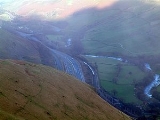
The valley of the Lune has three parts. The northern part between its source and Tebay
is called Lunesdale, which is followed by the spectacular Lune Gorge through which both the M6 motorway
and the West Coast Main Railway Line run. The part after the gorge in which the valley broadens out is known as Lonsdale.
Bridges over the Lune include the Devil's Bridge
near Kirkby Lonsdale
and the Lune Millennium Bridge
in Lancaster, through which it passes. At Caton, about 5 miles (8 km) upstream from Lancaster, there is a cluster of three bridges (one stone road bridge and two disused iron rail bridges now used as foot/cyclepaths) at the Crook o' Lune. Here in a 180 righthand the Lune turns back on itself, followed by another lefthand 90 degree bend forming the shape of a shepherd's crook and creating a beauty spot which was one of the locations in the area painted by J. M. W. Turner
.
The Lune is now tidal only below Skerton Weir in Lancaster. Four bridges in close proximity cross the estuary in Lancaster: Skerton Bridge
(road), Greyhound Bridge (built as rail but now carries a road), Lune Millennium Bridge (pedestrian) and Carlisle Bridge (carrying the West Coast Main Line
railway) which is the presently most downstream bridge. A Lancaster Western Bypass has been under discussion for many years. If it ever proceeds, a new bridge downstream from Carlisle bridge would be built. This part of the Lune is also the site of the old Port of Lancaster. Probably a port from Roman Times, the Lancaster Port Commission was established in 1750 to improve navigation on the estuary. Between 1750 and 1767, St George's Quay and New Quay were built in Lancaster and in 1779 the decision was taken to extend port facilities closer to the Irish Sea at Glasson Dock
.
Lancaster (and hence also Lancashire
) is named after the Lune. The river is a County Biological Heritage Site.
River
A river is a natural watercourse, usually freshwater, flowing towards an ocean, a lake, a sea, or another river. In a few cases, a river simply flows into the ground or dries up completely before reaching another body of water. Small rivers may also be called by several other names, including...
in Cumbria
Cumbria
Cumbria , is a non-metropolitan county in North West England. The county and Cumbria County Council, its local authority, came into existence in 1974 after the passage of the Local Government Act 1972. Cumbria's largest settlement and county town is Carlisle. It consists of six districts, and in...
and Lancashire
Lancashire
Lancashire is a non-metropolitan county of historic origin in the North West of England. It takes its name from the city of Lancaster, and is sometimes known as the County of Lancaster. Although Lancaster is still considered to be the county town, Lancashire County Council is based in Preston...
, England.
It is formed at Wath, in the parish of Ravenstonedale
Ravenstonedale
Ravenstonedale is a village and large civil parish in Cumbria, on the watershed between the River Lune and River Eden. Historically also known as "Russendale", the parish is divided into four parts, Town, Newbiggin-on-Lune, Bowderdale and Fell End.-Village:...
, Cumbria
Cumbria
Cumbria , is a non-metropolitan county in North West England. The county and Cumbria County Council, its local authority, came into existence in 1974 after the passage of the Local Government Act 1972. Cumbria's largest settlement and county town is Carlisle. It consists of six districts, and in...
, at the confluence of Sandwath Beck
Sandwath Beck
Sandwath Beck is a river running through Cumbria in England.The beck rises beneath Green Bell in Ravenstonedale as Dale Gill, changing its designation to Greenside Beck when it passes the village of Greenside....
and Weasdale Beck
Weasdale Beck
Weasdale Beck is a stream in Cumbria.The beck rises in Ravenstonedale and drains Leathgill Bridge on Randygill Top and Great Swindale, below Green Bell, flowing northwards to Wath, where, at its confluence with Sandwath Beck, Weasdale Beck forms the River Lune....
. The river then passes the remnants of a Roman
Roman Empire
The Roman Empire was the post-Republican period of the ancient Roman civilization, characterised by an autocratic form of government and large territorial holdings in Europe and around the Mediterranean....
fort near Low Borrowbridge at the foot of Borrowdale
Borrowdale, Westmorland
Borrowdale is a valley in the English Lake District. It is located in the old county of Westmorland, and is sometimes referred to as Westmorland Borrowdale in order to distinguish it from a more famous Borrowdale located in the traditional county of Cumberland.The valley straddles the eastern...
, and flows through south Cumbria, finally meeting the Irish Sea
Irish Sea
The Irish Sea separates the islands of Ireland and Great Britain. It is connected to the Celtic Sea in the south by St George's Channel, and to the Atlantic Ocean in the north by the North Channel. Anglesey is the largest island within the Irish Sea, followed by the Isle of Man...
at Plover Scar near Lancaster, after a total journey of about 44 miles (71 km).
The valley of the Lune has three parts. The northern part between its source and Tebay
Tebay
Tebay is a village and civil parish in Cumbria, England, within the traditional borders of Westmorland. It lies in the upper Lune Valley, at the head of the Lune Gorge. The parish of Tebay had a population of 728 recorded in the 2001 census,...
is called Lunesdale, which is followed by the spectacular Lune Gorge through which both the M6 motorway
M6 motorway
The M6 motorway runs from junction 19 of the M1 at the Catthorpe Interchange, near Rugby via Birmingham then heads north, passing Stoke-on-Trent, Manchester, Preston, Carlisle and terminating at the Gretna junction . Here, just short of the Scottish border it becomes the A74 which continues to...
and the West Coast Main Railway Line run. The part after the gorge in which the valley broadens out is known as Lonsdale.
Bridges over the Lune include the Devil's Bridge
Devil's Bridge
Devil’s Bridge is a term applied to dozens of ancient bridges, found primarily in Europe. Most of these bridges are stone or masonry arch bridges and represent a significant technological achievement...
near Kirkby Lonsdale
Kirkby Lonsdale
Kirkby Lonsdale is a small town and civil parish in the South Lakeland district of Cumbria, England, on the River Lune. Historically within Westmorland, it is situated south east of Kendal along the A65. The parish had a population of 1,771 recorded in the 2001 census.Notable buildings include St...
and the Lune Millennium Bridge
Lune Millennium Bridge
The Lune Millennium Bridge is a cable-stayed footbridge which spans the River Lune in Lancaster, England.It was designed by Whitby Bird and Partners, and built at a cost of £1.8m to commemorate the millennium of 2000. The bridge forms a "Y"-shape in plan to connect one bank both to a viaduct and...
in Lancaster, through which it passes. At Caton, about 5 miles (8 km) upstream from Lancaster, there is a cluster of three bridges (one stone road bridge and two disused iron rail bridges now used as foot/cyclepaths) at the Crook o' Lune. Here in a 180 righthand the Lune turns back on itself, followed by another lefthand 90 degree bend forming the shape of a shepherd's crook and creating a beauty spot which was one of the locations in the area painted by J. M. W. Turner
J. M. W. Turner
Joseph Mallord William Turner RA was an English Romantic landscape painter, watercolourist and printmaker. Turner was considered a controversial figure in his day, but is now regarded as the artist who elevated landscape painting to an eminence rivalling history painting...
.
The Lune is now tidal only below Skerton Weir in Lancaster. Four bridges in close proximity cross the estuary in Lancaster: Skerton Bridge
Skerton Bridge
Skerton Bridge is a road bridge carrying the southbound lanes of the A6 road over the River Lune in Lancaster, Lancashire, England. The bridge has been designated by English Heritage as a Grade II* listed building.-History:...
(road), Greyhound Bridge (built as rail but now carries a road), Lune Millennium Bridge (pedestrian) and Carlisle Bridge (carrying the West Coast Main Line
West Coast Main Line
The West Coast Main Line is the busiest mixed-traffic railway route in Britain, being the country's most important rail backbone in terms of population served. Fast, long-distance inter-city passenger services are provided between London, the West Midlands, the North West, North Wales and the...
railway) which is the presently most downstream bridge. A Lancaster Western Bypass has been under discussion for many years. If it ever proceeds, a new bridge downstream from Carlisle bridge would be built. This part of the Lune is also the site of the old Port of Lancaster. Probably a port from Roman Times, the Lancaster Port Commission was established in 1750 to improve navigation on the estuary. Between 1750 and 1767, St George's Quay and New Quay were built in Lancaster and in 1779 the decision was taken to extend port facilities closer to the Irish Sea at Glasson Dock
Glasson Dock
Glasson Dock, also known as Glasson, is a village in England, south of Lancaster, at the mouth of the River Lune. It is in the City of Lancaster district of Lancashire.-History:...
.
Lancaster (and hence also Lancashire
Lancashire
Lancashire is a non-metropolitan county of historic origin in the North West of England. It takes its name from the city of Lancaster, and is sometimes known as the County of Lancaster. Although Lancaster is still considered to be the county town, Lancashire County Council is based in Preston...
) is named after the Lune. The river is a County Biological Heritage Site.
Etymology
There are these theories about this river's name "Lune":- From a CelticCeltic languagesThe Celtic languages are descended from Proto-Celtic, or "Common Celtic"; a branch of the greater Indo-European language family...
word meaning "clean", "pure". - Via Anglo-Saxon Ēa Lōn (ēa = "river") as a phonetic adaptation of a CelticCeltic languagesThe Celtic languages are descended from Proto-Celtic, or "Common Celtic"; a branch of the greater Indo-European language family...
name referring to a Celtic god Ialonus who was worshipped in the area.
Tributaries
|
River Wenning The River Wenning is a tributary of the River Lune, flowing through North Yorkshire and Lancashire. The Wenning rises at Clapham in Yorkshire and flows westwards through High Bentham, Low Bentham and Wennington....
Gressingham Gressingham is a small village and civil parish in the City of Lancaster in the English county of Lancashire. It is north of the River Lune and across the river from Hornby. In the 2001 census, it had a population of 153.... )
River Greta (Lune) The River Greta is a river flowing through Lancashire and North Yorkshire in the north of England.The river is formed by the confluence of the River Twiss and the River Doe at Ingleton....
|
Leck Beck Leck Beck is a watercourse in Lancashire with its source on Crag Hill in Cumbria between Leck Fell and Casterton Fell.For several kilometres near the start of its course, the water flows into the Easegill Cave System, the longest cave system in Britain via 14 major sink holes to converge at a... Barbon Beck Barbon Beck is a small river in Cumbria.Rising at Weather Ling Hill, where it is known as Barkin Beck, the stream passes southwest down Barbondale to Fell House, where, joined by Aygill , now known as Barbon Beck, it takes a westerly course, past Barbon Manor and through the...
River Rawthey The River Rawthey is a river in Cumbria.The headwaters of the Rawthey are at Rawthey Gill Foot, where Rawthey Gill, whose own source is a confluence at Gill Head on East Baugh Fell, meets Haskhaw Gill....
Borrow Beck Borrow Beck is a stream running through Cumbria, England.Rising at Borrowdale Moss near Lord's Seat, the beck runs a southeasterly course, being joined by Crookdale Beck before running through Borrowdale....
|
Birk Beck Birk Beck is a minor river in Cumbria.Rising on the fells near Shap, Birk Beck runs south-by-south east, picking up Wasdale Beck and Bretherdale Beck before falling into the River Lune near the head of the Lune Gorge by Castle Howe close to Old Tebay....
|