
Witherslack
Encyclopedia
Witherslack is a small village and civil parish in the south of Cumbria
. It lies on the north eastern side of Morecambe Bay
, England
. The eastern side of the village borders Whitbarrow
Scar with Yewbarrow, which is a small limestone hill, located in the centre of the village
Witherslack is quite scattered with four distinct areas. Townend, Mill Side, Beck Head and the school/church. Townend is traditionally considered the centre of the village and contains the local pub The Derby Arms and the Community Shop. Mill Side is the location of the old Mill and still contains the mill pond. Beck Head lies to the north of Mill Side and is where a small river emerges from the limestone escarpment adjacent to Whitbarrow
. The area of the village with the Dean Barwick C of E School and St. Paul's church lies to the west of Yewbarrow.
is the only place of worship in the village.
The newly refurbished Derby Arms has several real ales and a selection of good food.
Witherslack also has a Community Shop which has the usual provisions and is also an outlet for local produce.
.
Cumbria
Cumbria , is a non-metropolitan county in North West England. The county and Cumbria County Council, its local authority, came into existence in 1974 after the passage of the Local Government Act 1972. Cumbria's largest settlement and county town is Carlisle. It consists of six districts, and in...
. It lies on the north eastern side of Morecambe Bay
Morecambe Bay
Morecambe Bay is a large bay in northwest England, nearly due east of the Isle of Man and just to the south of the Lake District National Park. It is the largest expanse of intertidal mudflats and sand in the United Kingdom, covering a total area of 310 km².-Natural features:The rivers Leven,...
, England
England
England is a country that is part of the United Kingdom. It shares land borders with Scotland to the north and Wales to the west; the Irish Sea is to the north west, the Celtic Sea to the south west, with the North Sea to the east and the English Channel to the south separating it from continental...
. The eastern side of the village borders Whitbarrow
Whitbarrow
Whitbarrow is a Site of Special Scientific Interest and National Nature Reserve in Cumbria, and forms part of the Morecambe Bay Pavements Special Area of Conservation due to its supporting some of the best European examples of natural limestone habitats...
Scar with Yewbarrow, which is a small limestone hill, located in the centre of the village
Witherslack is quite scattered with four distinct areas. Townend, Mill Side, Beck Head and the school/church. Townend is traditionally considered the centre of the village and contains the local pub The Derby Arms and the Community Shop. Mill Side is the location of the old Mill and still contains the mill pond. Beck Head lies to the north of Mill Side and is where a small river emerges from the limestone escarpment adjacent to Whitbarrow
Whitbarrow
Whitbarrow is a Site of Special Scientific Interest and National Nature Reserve in Cumbria, and forms part of the Morecambe Bay Pavements Special Area of Conservation due to its supporting some of the best European examples of natural limestone habitats...
. The area of the village with the Dean Barwick C of E School and St. Paul's church lies to the west of Yewbarrow.
Amenities
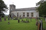
St Paul's ChurchSt Paul's Church, Witherslack
St Paul's Church, Witherslack, is located in the village of Witherslack, Cumbria, England. It is an active Anglican parish church in the deanery of Kendal, the archdeaconry of Westmorland and Furness, and the diocese of Carlisle. It has been designated by English Heritage as a Grade II*...
is the only place of worship in the village.
The newly refurbished Derby Arms has several real ales and a selection of good food.
Witherslack also has a Community Shop which has the usual provisions and is also an outlet for local produce.
Schools
There are two schools in Witherslack;- Dean Barwick Primary School
- Witherslack Hall SchoolWitherslack Hall SchoolWitherslack Hall School is in the village of Witherslack near Grange-over-Sands, Cumbria, England. It is a residential and day school for boys aged 11-19 with special educational needs, including complex learning, communication, behavioural, emotional and social difficulties. It holds places for...
which provides education for boys with behavioural and associated learning difficulties.
Geography
Witherslack sits on slate with carboniferous limestone forming the outcrops of Whitbarrow and Yewbarrow.Landmarks
East of the church and north of Townend lies Nether Hall, which was the 15th century home of the Harrington family. The present 16th and 17th century building incorporates walls 5 feet thick, which are probably the remains of a pele towerPeel tower
Peel towers are small fortified keeps or tower houses, built along the English and Scottish borders in the Scottish Marches and North of England, intended as watch towers where signal fires could be lit by the garrison to warn of approaching danger...
.
External links
- Witherslack village website