
List of Massachusetts rivers
Encyclopedia
List of river
s in Massachusetts
(U.S. state
).
All Massachusetts rivers flow to the Atlantic Ocean
. The list is arranged by drainage basin
from north to south, with respective tributaries
indented under each larger stream's name, arranged travelling upstream along the larger stream.
Gulf of Maine
Massachusetts Bay
Cape Cod Bay
Nantucket Sound
Buzzards Bay
Narragansett Bay
Long Island Sound


New York Harbor
River
A river is a natural watercourse, usually freshwater, flowing towards an ocean, a lake, a sea, or another river. In a few cases, a river simply flows into the ground or dries up completely before reaching another body of water. Small rivers may also be called by several other names, including...
s in Massachusetts
Massachusetts
The Commonwealth of Massachusetts is a state in the New England region of the northeastern United States of America. It is bordered by Rhode Island and Connecticut to the south, New York to the west, and Vermont and New Hampshire to the north; at its east lies the Atlantic Ocean. As of the 2010...
(U.S. state
U.S. state
A U.S. state is any one of the 50 federated states of the United States of America that share sovereignty with the federal government. Because of this shared sovereignty, an American is a citizen both of the federal entity and of his or her state of domicile. Four states use the official title of...
).
All Massachusetts rivers flow to the Atlantic Ocean
Atlantic Ocean
The Atlantic Ocean is the second-largest of the world's oceanic divisions. With a total area of about , it covers approximately 20% of the Earth's surface and about 26% of its water surface area...
. The list is arranged by drainage basin
Drainage basin
A drainage basin is an extent or an area of land where surface water from rain and melting snow or ice converges to a single point, usually the exit of the basin, where the waters join another waterbody, such as a river, lake, reservoir, estuary, wetland, sea, or ocean...
from north to south, with respective tributaries
Tributary
A tributary or affluent is a stream or river that flows into a main stem river or a lake. A tributary does not flow directly into a sea or ocean...
indented under each larger stream's name, arranged travelling upstream along the larger stream.
Gulf of MaineGulf of MaineThe Gulf of Maine is a large gulf of the Atlantic Ocean on the east coast of North America.It is delineated by Cape Cod at the eastern tip of Massachusetts in the southwest and Cape Sable at the southern tip of Nova Scotia in the northeast. It includes the entire coastlines of the U.S...
north of Cape AnnCape AnnCape Ann is a rocky cape in northeastern Massachusetts on the Atlantic Ocean. The cape is located approximately 30 miles northeast of Boston and forms the northern edge of Massachusetts Bay. Cape Ann includes the city of Gloucester, and the towns of Essex, Manchester-by-the-Sea, and...
- Blackwater River
- Little River
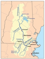
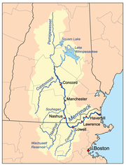
- Merrimack RiverMerrimack RiverThe Merrimack River is a river in the northeastern United States. It rises at the confluence of the Pemigewasset and Winnipesaukee rivers in Franklin, New Hampshire, flows southward into Massachusetts, and then flows northeast until it empties into the Atlantic Ocean at Newburyport...
- Back River (Merrimack River)
- Powwow RiverPowwow RiverThe Powwow River is a river located in New Hampshire and Massachusetts in the United States. It is a tributary of the Merrimack River, part of the Gulf of Maine watershed.-River course:...
- Back River (Lake Attitash)
- Back River (Powwow River)Back River (Powwow River)The Back River is a river located in New Hampshire and Massachusetts in the United States. It is a tributary of the Powwow River, part of the Merrimack River watershed. Approximately of the river are in New Hampshire, with the remaining in Massachusetts....
- Artichoke River
- Indian River
- East Meadow River
- Little RiverLittle River (Merrimack River)The Little River is a river located in New Hampshire and Massachusetts in the United States. It is a tributary of the Merrimack River, part of the Gulf of Maine watershed....
- Cochichewick RiverCochichewick RiverThe Cochichewick River, also known as Cochichewick Brook, is a stream in North Andover, Massachusetts, that drains water from Lake Cochichewick into the Merrimack River.- Early history :...
- Shawsheen RiverShawsheen RiverThe Shawsheen River is a tributary of the Merrimack River in northeast Massachusetts. The name has had various spellings. According to Bailey's history of Andover, the spelling Shawshin was the most common in the old records, although Shawshine, Shashin, Shashine, Shashene, Shawshene, and later,...
- Spicket RiverSpicket RiverThe Spicket River is a river located in New Hampshire and Massachusetts in the United States. It is a tributary of the Merrimack River, part of the Gulf of Maine watershed. It is sometimes spelled "Spickett"....
- Concord RiverConcord RiverThe Concord River is a tributary of the Merrimack River in eastern Massachusetts in the United States. The river drains a small rural and suburban region northwest of Boston. One of the most famous small rivers in U.S...
- Assabet RiverAssabet RiverThe Assabet River is a small river about west of Boston, Massachusetts. The river is long. The , headquartered in West Concord, Massachusetts, is a non-profit organization dedicated to the preservation, protection, and enhancement of the natural and recreational features of the Assabet River and...
- Sudbury RiverSudbury RiverThe Sudbury River is a tributary of the Concord River in Middlesex County, Massachusetts, in the United States.Originating in the Cedar Swamp in Westborough, Massachusetts, near the boundary with Hopkinton, it meanders generally northeast to its confluence with the Assabet River at Egg Rock in...
- Assabet River
- Beaver BrookBeaver Brook (Merrimack River)Beaver Brook is a river located in New Hampshire and Massachusetts in the United States. It is a tributary of the Merrimack River, part of the Gulf of Maine watershed....
- Salmon BrookSalmon Brook (Merrimack River)Salmon Brook is one of the 6 major tributaries of the Merrimack River in northeastern Massachusetts in the United States. Its watershed is and is one of the 14 subwatersheds of the Merrimack River. It passes through Groton, Dunstable, and Tyngsborough, Massachusetts, and then through Nashua, New...
- Nashua RiverNashua RiverThe Nashua River, long, is a tributary of the Merrimack River in Massachusetts and New Hampshire in the United States. It is formed in eastern Worcester County, Massachusetts, by junction of its north and south branches near Lancaster, and flows generally north-northeast past Groton to join the...
- Nissitissit RiverNissitissit RiverThe Nissitissit River is a river located in southern New Hampshire and northern Massachusetts in the United States. It is a tributary of the Nashua River, itself a tributary of the Merrimack River, which flows to the Gulf of Maine. This river is part of the Nashua River Watershed.The Nissitissit...
- Squannacook RiverSquannacook RiverThe Squannacook River is a river in northern Massachusetts. It is a tributary of the Nashua River and part of the Merrimack River watershed flowing to the Atlantic Ocean....
- Still River
- North Nashua River
- Whitman River
- Quinapoxet RiverQuinapoxet RiverThe Quinapoxet River is part of the Nashua River watershed in northern Massachusetts in the United States. It is part of the Massachusetts Water Resources Authority water system supplying drinking water to the greater Boston area....
- Stillwater RiverStillwater River (Nashua River)The Stillwater River is part of the Nashua River watershed. This river is part of the Massachusetts Water Resources Authority system that supplies drinking water to the greater Boston area....
- Nissitissit River
- Souhegan River (NH)
- South Branch Souhegan RiverSouth Branch Souhegan RiverThe South Branch of the Souhegan River is a river located in northern Massachusetts and southern New Hampshire in the United States. It is a tributary of the Souhegan River, which flows to the Merrimack River and ultimately to the Gulf of Maine....
- South Branch Souhegan River
- Parker RiverParker River National Wildlife RefugeParker River National Wildlife Refuge was established in 1942 primarily to provide feeding, resting, and nesting habitats for migratory birds. Located along the Atlantic Flyway, the refuge is of vital stopover significance to waterfowl, shorebirds, and songbirds during migratory periods.The refuge...
- Little River
- Mill River
- Rowley RiverRowley RiverThe Rowley River is a small river between Ipswich and Rowley, Massachusetts.The river lies within in the estuary of Plum Island Sound, and is formed by the confluence of the Egypt River and Muddy Run in Ipswich, with numerous tributaries in the estuary...
- Roger Island RiverRoger Island RiverThe Roger Island River is a small tidal estuary between Ipswich and Rowley, Massachusetts. It is a southern branch of the larger Rowley River passing around Roger Island....
- Egypt RiverEgypt RiverThe Egypt River is a stream in Ipswich, Massachusetts, United States.The river is formed by the confluence of Bull and Dow brooks below their reservoirs, and in turn joins the Muddy River and then the Rowley River, which empties into the Plum Island Sound...
- Roger Island River
- Eagle Hill RiverEagle Hill RiverThe Eagle Hill River is a small river in Ipswich, Massachusetts.The river arises within salt marshes just north of Ipswich, and empties into the Plum Island Sound. Broad and shallow, its total length is approximately 2 miles.See also: Bagwell Island....
- Ipswich RiverIpswich RiverIpswich River is a small river in northeastern Massachusetts, USA. It is long, and its watershed is approximately , with an estimated population in the area of 160,000 people. - Geography :...
- Miles River
- Martins Brook
- Skug RiverSkug RiverThe Skug River, said to be a misspelling of Skunk River, is a river in North Andover, Andover, and North Reading, Massachusetts that constitutes part of the Ipswich River watershed....
- Skug River
- Castle Neck River
- Essex River
- Farm Creek
- Walker Creek
- Annisquam RiverAnnisquam RiverThe Annisquam River is a tidal, salt-water estuary in Annisquam and Gloucester, Massachusetts, connecting Annisquam Harbor on the north to Gloucester Harbor on the south. The segment between Gloucester Harbor and the Boston and Maine railroad bridge is also known as the Blynman Canal.The estuary is...
- Jones River
- Little River
- Mill River
Massachusetts BayMassachusetts BayThe Massachusetts Bay, also called Mass Bay, is one of the largest bays of the Atlantic Ocean which forms the distinctive shape of the coastline of the U.S. state of Massachusetts. Its waters extend 65 miles into the Atlantic Ocean. Massachusetts Bay includes the Boston Harbor, Dorchester Bay,...
- Danvers River
- North River
- Bass River
- Forest River
- Saugus RiverSaugus RiverThe Saugus River is a river in Massachusetts.The river is long, drains a watershed of approximately , and passes through Wakefield, Lynnfield, Saugus, and Lynn as it meanders east and south from its source in Lake Quannapowitt in Wakefield to its mouth at Boston Broad Sound...
- Pines River
- Mill River
- Mystic RiverMystic RiverThe Mystic River is a river in Massachusetts, in the United States. Its name derives from the Wampanoag word "muhs-uhtuq", which translates to "big river." In an Algonquian language, "Missi-Tuk" means "a great river whose waters are driven by waves", alluding to the natural tidal nature of the...
- Chelsea CreekChelsea CreekChelsea Creek, shown on federal maps as the Chelsea River, is a waterway that runs along the shore of Chelsea, Massachusetts and separates that community from the cities of Boston and Revere as well as feeding part of the current Belle Isle Marsh Reservation that separates Boston from Revere...
- Island End River
- Malden RiverMalden RiverThe Malden River is a river in Malden, Massachusetts. It is roughly wide at its widest point and is very narrow at its smallest point. Its banks are largely occupied by industrial business, and the river is scarcely used or even mentioned. Its water quality is worse than most local waters,...
- Alewife Brook
- Little River
- Aberjona RiverAberjona RiverThe Aberjona River is a , heavily urbanized river in the northwestern suburbs of Boston, Massachusetts.The river arises in Reading, flows roughly south through Woburn and Winchester, and empties into the Mystic Lakes...
- Chelsea Creek
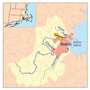
- Charles RiverCharles RiverThe Charles River is an long river that flows in an overall northeasterly direction in eastern Massachusetts, USA. From its source in Hopkinton, the river travels through 22 cities and towns until reaching the Atlantic Ocean at Boston...
- Muddy River
- Stop RiverStop RiverThe Stop River is a low and marshy stream in Medfield, Massachusetts, and partly forming the border between Norfolk and Walpole. The river rises near Highland Lake in Walpole, flows northwards to join the Charles River in Medfield, and ultimately drains into Boston Harbor.The Medfield...
- Mill River
- West Branch Charles River
- Neponset RiverNeponset RiverThe Neponset River is a river in eastern Massachusetts in the United States. The headwaters of the Neponset are at the Neponset Reservoir in Foxborough, near the Gillette Stadium...
- East Branch Neponset River
- Weymouth Fore RiverWeymouth Fore RiverWeymouth Fore River is a small bay or estuary in eastern Massachusetts and is part of the Massachusetts Bay watershed.The headwater of Weymouth Fore River is formed by the confluence of the Monatiquot River and Smelt Brook in the Weymouth Landing area of Braintree...
- Monatiquot RiverMonatiquot RiverThe Monatiquot River is a river in Braintree, Massachusetts, formed by the confluence of the Farm River and Cochato River in the Braintree Municipal Golf Course, flowing in swampy meanders to the northeast, and emptying into the tidal Weymouth Fore River estuary. Its drainage area is .The river...
- Cochato RiverCochato RiverThe Cochato River is a stream rising from Avon, Massachusetts and running several miles north to its confluence with the Monatiquot River in Braintree. It is part of the Weymouth Fore River watershed and empties into Boston Harbor....
- Farm River
- Blue Hill River
- Cochato River
- Monatiquot River
- Weymouth Back RiverWeymouth Back RiverThe Weymouth Back River, sometimes called Back River, is a short, primarily tidal river in Hingham and Weymouth, Massachusetts, about south of Boston...
- Fresh River
- Mill River
- Old Swamp River
- Weir RiverWeir River (Massachusetts)Weir River is a short stream and estuary that empties into Hingham Bay, part of Boston Harbor in Massachusetts, United States. The name is attributed to the location of a fishing weir in the stream...
- Crooked Meadow River
- Plymouth River
- Crooked Meadow River
- Bound Brook (In 1640 Bound Brook formed the border between the Massachusetts BayMassachusetts Bay ColonyThe Massachusetts Bay Colony was an English settlement on the east coast of North America in the 17th century, in New England, situated around the present-day cities of Salem and Boston. The territory administered by the colony included much of present-day central New England, including portions...
and PlymouthPlymouth ColonyPlymouth Colony was an English colonial venture in North America from 1620 to 1691. The first settlement of the Plymouth Colony was at New Plymouth, a location previously surveyed and named by Captain John Smith. The settlement, which served as the capital of the colony, is today the modern town...
colonies.)- Aaron River
- North RiverNorth River (Massachusetts Bay)The North River is a river, approximately long, in eastern Massachusetts, the United States. It is primarily a tidal river, formed by the confluence of the Indian Head River and Herring Brook. The North River forms the boundary between the towns of Norwell and Pembroke, Massachusetts, and...
- East Branch North River
- Indian Head RiverIndian Head RiverThe Indian Head River is located on the Hanover, Pembroke border in Massachusetts, United States, and covers about . The river, long, is a tributary of the North River, which flows into Massachusetts Bay...
- Drinkwater River
- West Branch North River
- South River
Cape Cod BayCape Cod BayCape Cod Bay is a large bay of the Atlantic Ocean adjacent to the U.S. state of Massachusetts. Measuring below a line drawn from Brant Rock in Marshfield to Race Point in Provincetown, Massachusetts, it is enclosed by Cape Cod to the south and east, and Plymouth County, Massachusetts, to the west....
- Green Harbor River
- Back River
- Pine Point River
- Great Wood Island River
- Little Wood Island River
- Duck Hill River
- Bourne Wharf River
- Bluefish River
- Jones RiverJones RiverThe Jones River is a river running through Kingston, Massachusetts. The river drains about , has its source in Silver Lake and drains into Kingston Bay. Land surrounding the river is 52% forested, of which 22% has been developed for residential use...
- Town BrookTown Brook (Massachusetts)Town Brook is a stream in Plymouth, Massachusetts that provided drinking water to the Pilgrims who made their homes adjacent to the brook on Leyden Street in Plymouth. Town Brook's headwaters are the Billington Sea, a freshwater pond. The brook passes through numerous small ponds, including Deep...
- Eel RiverEel River (Massachusetts)The Eel River is a river mostly in the village of Chiltonville in Plymouth, Massachusetts. Its headwaters are springs and small ponds above Russell Millpond. Its watershed encompasses approximately...
- Boat Meadow River
- Pamet RiverPamet RiverThe Pamet River is a river in Truro, Massachusetts on Cape Cod. It is named for the Paomet tribe.The river is primarily salt marsh, flows west nearly all the way across Cape Cod from its eastern beaches, and empties into Cape Cod Bay. It lies a few miles south of the Little Pamet River.The upper...
- Little Pamet RiverLittle Pamet RiverThe Little Pamet River is a river in Truro, Massachusetts on Cape Cod.The river arises in wetlands, flows west for about one mile, and drains into Cape Cod Bay. The nearby Pamet River lies a few miles to the south....
- Herring River (5 streams, all on Cape CodCape CodCape Cod, often referred to locally as simply the Cape, is a cape in the easternmost portion of the state of Massachusetts, in the Northeastern United States...
)
Nantucket SoundNantucket SoundNantucket Sound is a roughly triangular area of the Atlantic Ocean offshore from the U.S. state of Massachusetts. It is long and wide, and is enclosed by Cape Cod on the north, Nantucket on the south, and Martha's Vineyard on the west. Between Cape Cod and Martha's Vineyard it is connected to the...
- Mitchell RiverMitchell River (Massachusetts)The Mitchell River is a river in Chatham, Massachusetts on Cape Cod. It is an estuary connecting Mill Pond to Stage Harbor....
- Oyster Pond RiverOyster Pond RiverOyster Pond River, also called Oyster Creek, is a river in Chatham, Massachusetts on Cape Cod.The river is an estuary connecting Oyster Pond with Stage Harbor, averaging in depth and bordered with salt marshes. Both river and pond provide excellent anchorage. According to an assessment for the...
- Andrews River
- Red River
- Swan Pond River
- Bass River
- Parkers River
- Centerville River
- Bumps RiverBumps RiverThe Bumps River is a small river in Centerville, on Cape Cod, Massachusetts. It is a tributary of the Centerville River....
- Bumps River
- Marstons Mill River
- Little River
- Santuit RiverSantuit RiverThe Santuit River, also known as the Cotuit River, is a river on the border between Mashpee and Cotuit, Massachusetts on Cape Cod.The river flows southwards from the southern end of Santuit Pond into Popponesset Bay on the south shore of Cape Cod.The river was a vigorous herring/alewife run and...
- Mashpee RiverMashpee RiverThe Mashpee River is a tidal river on Cape Cod in Mashpee, Massachusetts.The river arises in Mashpee and Wakeby Ponds, flows south a short distance, and drains into Pirate's Cove on Popponesset Bay on the Nantucket Sound...
- Quashnet RiverQuashnet RiverThe Quashnet River, also known as Quoshnet River or Moonakis River, is a estuary in Falmouth, Massachusetts on Cape Cod. Its area is about ....
- Childs RiverChilds RiverThe Childs River, also known as Child's River, is a river near Falmouth, Massachusetts on Cape Cod. Its drainage area is about . It has been heavily impacted by the development of cranberry bogs in its upper reaches....
- Seapit River
- Coonamesset RiverCoonamesset RiverThe Coonamesset River is a river in Falmouth, Massachusetts on Cape Cod. The river has its headwaters in Coonamessett Pond, flows generally south to Great Pond estuary, and empties into the Vineyard Sound just east of Falmouth Heights...
Buzzards BayBuzzards BayBuzzards Bay is a bay along the southern edge of Massachusetts in the United States. The name may also refer to:*Buzzards Bay, Massachusetts, a village in Bourne, Massachusetts*Buzzards Bay , the name of the horse that won the 2005 Santa Anita Derby...
- Wild Harbor River
- Pocasset River
- Back RiverBack River (Buzzards Bay)The Back River is a small tidal estuary in Bourne, Massachusetts on the eastern shore of Buzzards Bay. It lies just south of the Cape Cod Canal near the village of Monument Beach. It is separated from Buzzards Bay by Phinneys Harbor...
- Wareham River
- Crooked RiverCrooked River (Massachusetts)The Crooked River is a small tributary of the Wareham River located entirely within the town of Wareham, Massachusetts . Its source is found in salt marshes and cranberry bogs east of Indian Neck Road, and its mouth empties into the Wareham River opposite Swifts Neck...
- Broad Marsh River
- Agawam RiverAgawam RiverThe Agawam River is a stream in southeastern Massachusetts, USA, that is part of the Wareham River estuary watershed. The Agawam River is named in honor of the peaceful Native Americans that helped the Massachusetts Bay Colony establish its first Connecticut River Valley settlement at Springfield,...
- Wankinco RiverWankinco RiverThe Wankinco River is a river in eastern Massachusetts and a tributary of the Wareham River, which drains into Buzzards Bay.Although now spelled Wankinco, it was previously written as Wankinquoah, which may have been derived from Wonqun, meaning "crooked".The Wankinco River originates at East Head...
- Crooked River
- Weweantic RiverWeweantic RiverThe Weweantic River is a river in southeastern Massachusetts. Its name means "crooked" or "wandering stream" in the Wampanoag language.The river arises in wetlands in Carver, meanders generally south through swampy birch and maple forests in Middleborough and Rochester, and drains into a Buzzards...
- Sippican RiverSippican RiverThe Sippican River is a short river in Massachusetts, United States.The Sippican River is long, arising from east and west branches in the towns of Mattapoisett, Marion , and Rochester, Massachusetts...
- East Branch Sippican River
- West Branch Sippican River
- Sippican River
- Mattapoisett RiverMattapoisett RiverThe Mattapoisett River is an river in southeastern Massachusetts, in the United States.The river begins at Snipatuit Pond in Rochester and flows generally southwards through Mattapoisett to empty into Mattapoisett Harbor, an arm of Buzzards Bay...
- Nasketucket RiverNasketucket RiverThe Nasketucket River is a small river arising in Fairhaven, Massachusetts, and emptying about 3 miles downstream into Little Bay, a branch of Nasketucket Bay on Buzzards Bay....
- Acushnet RiverAcushnet RiverThe Acushnet River is the largest river, long, flowing into Buzzards Bay in southeastern Massachusetts, in the United States. The name "Acushnet" comes from the Wampanoag or Algonquian word, "Cushnea", meaning "as far as the waters", a word that was used by the original owners of the land in...
- Keene River
- Little River
- Slocums RiverSlocums RiverSlocums River is a tidal river in southeastern Massachusetts in the United States...
- Paskamanset RiverPaskamanset RiverThe Paskamanset River, also known as the Paskamansett River, is a river in New Bedford and Dartmouth, Massachusetts. The Paskamanset and Slocums River really form just a single river, but the freshwater portion kept its earlier Indian name, while the salt-water portion is named for its English...
- Paskamanset River
- Westport RiverWestport RiverThe Westport River lies between Narragansett Bay and Buzzards Bay in Westport, Massachusetts.-Description:The Westport River has two branches. The smaller West Branch is approximately long, rising from a confluence of brooks near the village of Adamsville, Rhode Island...
- East Branch Westport River
- Shingle Island River
- Copicut RiverCopicut RiverThe Copicut River, or Copecut River, is a stream in the U.S. state of Massachusetts.The river flows south from Copicut Reservoir , in Dartmouth and Fall River, to Cornell Pond near Hixville in Dartmouth...
- Copicut River
- Shingle Island River
- West Branch Westport River
- East Branch Westport River
Narragansett BayNarragansett BayNarragansett Bay is a bay and estuary on the north side of Rhode Island Sound. Covering 147 mi2 , the Bay forms New England's largest estuary, which functions as an expansive natural harbor, and includes a small archipelago...
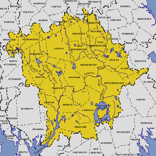
- Taunton RiverTaunton RiverThe Taunton River , is a river in southeastern Massachusetts in the United States. It arises from the confluence of the Town River and Matfield River, in the town of Bridgewater...
- Quequechan RiverQuequechan RiverThe Quequechan River , is a river in Fall River, Massachusetts that flows in a northwesterly direction from the South Watuppa Pond to the Taunton River. The word Quequechan means "falling water" in Wampanoag, hence the city's name....
- Assonet RiverAssonet RiverThe Assonet River is located in Bristol County, Massachusetts. It flows in a westerly direction through Freetown and joins the Taunton River near Assonet Neck in Berkley, Massachusetts. -Description:...
- Cedar Swamp RiverCedar Swamp RiverThe Cedar Swamp River is a small river in Lakeville, Massachusetts that flows in a northwesterly direction through the western part of the town to where it forms the Assonet River near the Freetown line, just south of the village of Myricks...
- Cedar Swamp River
- Segreganset RiverSegreganset RiverThe Segreganset River is a small river in Bristol County, Massachusetts that flows in a southeasterly direction through Taunton and Dighton into the Taunton River. Named tributaries include the Maple Swamp, Poppasquash Swamp, Sunken Brook and Cedar Swamp....
- Three Mile RiverThree Mile RiverThe Three Mile River or Threemile River is a river in Bristol County, Massachusetts. It is formed by the junction of the Rumford and Wading rivers in the town of Norton...
- Rumford RiverRumford RiverThe Rumford River is a small river in southeastern Massachusetts, United States, that is a tributary of the Threemile River in the Taunton River watershed. The Rumford River, long, begins within the town of Foxborough and flows south through Mansfield to the Norton Reservoir, within the town of...
- Wading RiverWading River (Massachusetts)The Wading River is a river in southeastern Massachusetts in the United States. It rises from Lake Miramichi in the town of Foxborough and flows southeast through Mansfield into the town of Norton, where it turns east, flows through Barrowsville Pond, and continues to its confluence with the...
- Rumford River
- Mill River
- Snake RiverSnake River (Massachusetts)The Snake River is a small river in Bristol County, Massachusetts. It flows fromWinnecunnet Pond to Lake Sabbatia in the northern part of Taunton, Massachusetts....
- Canoe RiverCanoe RiverThe Canoe River is a river in southeastern Massachusetts. It is long and part of the Taunton River watershed.The Canoe River arises from headwaters near Lake Massapoag in Sharon, and meanders generally southwards through the towns of Sharon, Foxborough, Mansfield, and Easton to empty into...
- Canoe River
- Snake River
- Forge RiverForge RiverThe Forge River is a river in the town of Raynham in southeastern Massachusetts. It is a tributary of the Taunton River. It rises from Gushee Pond near Interstate 495 and flows northwest through Titicut Swamp, then turns southwest for the rest of its course...
- Cotley RiverCotley RiverThe Cotley River is a small river in Taunton and Berkley, Massachusetts that is a tributary of the Taunton River. It flows approximately 5.8 miles in a northwesterly direction from the southeast part of Taunton near Seekell Street to Barstows Pond near the village of East Taunton where it joins...
- Nemasket RiverNemasket RiverThe Nemasket or Namasket River is a small river in southeastern Massachusetts. It flows north from Assawompset Pond in Lakeville and through Middleborough where it empties into the Taunton River....
- Winnetuxet RiverWinnetuxet RiverThe Winnetuxet River is a river in southeastern Massachusetts. It flows west from an unnamed pond near Cole Mill in Carver, through Plympton and Halifax, to the Taunton River.-External links:*...
- Matfield RiverMatfield RiverThe Matfield River is a river in Plymouth County, Massachusetts. It flows south through the town of East Bridgewater to a confluence with the Town River, forming the Taunton River. The Matfield River, where it flows through the historic village of Elmwood and flows under Route 18, is commonly...
- Satucket RiverSatucket RiverThe Satucket River is river in southeastern Massachusetts within the Taunton River Watershed. It flows generally west from Robbins Pond in East Bridgewater, and into the Matfield River.-References:...
- Poor Meadow BrookPoor Meadow BrookPoor Meadow Brook is a stream within the Taunton River Watershed in southeastern Massachusetts. The stream runs from a wetland near County Street in Hanson to the confluence with the Satucket River in East Bridgewater....
- Shumatuscacant RiverShumatuscacant RiverThe Shumatuscacant River is an river running through Abington and Whitman, Massachusetts. It forms part of the Taunton River Watershed.The river arises in a wetland just west of Vineyard Road, Abington, and flows to Poor Meadow Brook in Hanson, which then flows southwest to Robbins Pond...
- Stream River
- Shumatuscacant River
- Poor Meadow Brook
- Salisbury Plain RiverSalisbury Plain RiverThe Salisbury Plain River is a river in Plymouth County, Massachusetts that flows from the city of Brockton into the towns of West Bridgewater and East Bridgewater where it joins the Matfield River, a major tributary of the Taunton River....
- Satucket River
- Town RiverTown RiverThe Town River is a river in Plymouth County, Massachusetts. It flows from the northeast end of Lake Nippenicket in the town of Bridgewater, flowing easterly through West Bridgewater, then south back into Bridgewater where it joins with the Matfield River to form the Taunton...
- Hockomock RiverHockomock RiverThe Hockomock River is a stream in West Bridgewater, Massachusetts. It is a tributary of the Town River.Hockomock is said to mean "Place where Spirits Dwell" in the Wampanoag language. The river arises in the Hockomock Swamp, and flows south to its confluence with the Town River which eventually...
- Hockomock River
- Quequechan River
- Lees RiverLees RiverThe Lees River or Lee's River, shown on federal maps as the Lee River, is a tidal river that forms part of the boundary between Swansea and Somerset, Massachusetts. It flows south to drain into Mount Hope Bay....
- Cole RiverCole RiverThe Cole River is located in Bristol County, Massachusetts. It flows from its headwaters in Dighton, Massachusetts through the towns of Rehoboth and Swansea into Mount Hope Bay, an arm of Narragansett Bay. The Cole River becomes tidal after crossing under the G.A.R. Highway The Cole River is...
- Kickamuit RiverKickamuit RiverThe Kickamuit River is a river in the U.S. states of Massachusetts and Rhode Island flowing approximately .-History:The river's name descends from a Narragansett dialect and has numerous spellings...
- Warren River (RI)
- Barrington River (RI)
- Runnins RiverRunnins RiverThe Runnins River is a river in the U.S. states of Massachusetts and Rhode Island. It flows approximately 14 km .-Course:The river begins in Seekonk, Massachusetts in the swamps east of Prospect Street, near Walker Street...
- Runnins River
- Palmer RiverPalmer River (Massachusetts-Rhode Island)The Palmer River is a river in the U.S. states of Massachusetts and Rhode Island. It flows approximately 17 km .-Course:The river has two separate branches which converge near the intersection of Danforth Street and Winthrop Street The Palmer River is a river in the U.S. states of...
- East Branch Palmer River
- West Branch Palmer River
- Barrington River (RI)
- Seekonk River (RI)
- Ten Mile RiverTen Mile RiverThe Ten Mile River is a river within the U.S. states of Massachusetts and Rhode Island. It flows approximately and drains a watershed of .The North Attleborough National Fish Hatchery is located in its upper reaches, and the river offers stocked trout fishing in the spring.The Ten Mile River was...
- Wilde RiverWilde RiverWilde Brook is a stream in Seekonk, Massachusetts and Pawtucket, Rhode Island. It begins at Bitersweet Pond in Seekonk and flows 5.2 miles to it's confluence with the Ten Mile River in Pawtucket.-West Branch:...
- Sevenmile River
- Bungay RiverBungay RiverThe Bungay River is a short river in southeastern Massachusetts that is a tributary of the Ten Mile River.The Bungay River begins in Witch Pond in Foxborough, Massachusetts at an altitude of about above sea level. It flows south through Greenwood Lake and through North Attleboro and Attleboro. It...
- Wilde River
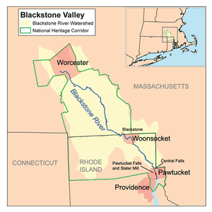
- Blackstone RiverBlackstone RiverThe Blackstone River is a river in the U.S. states of Massachusetts and Rhode Island. It flows approximately 48 mi and drains a watershed of approximately 540 sq. mi...
- Abbott RunAbbott RunAbbott Run is a de facto river in the U.S. states of Massachusetts and Rhode Island. It flows approximately 16 km .-Course:...
- Peters RiverPeters RiverThe Peters River is a river in the U.S. states of Massachusetts and Rhode Island. It flows .-Course:The river rises from Curtis Pond in Bellingham, Massachusetts, flowing south through Bellingham and into Woonsocket, Rhode Island where is flows into the Blackstone River.-Crossings:Below is a list...
- Mill River
- Branch River (RI)
- Clear River (RI)
- Nipmuc River (RI)
- Chockalog RiverChockalog RiverThe Chockalog River is a river in the U.S. states of Massachusetts and Rhode Island. It flows approximately 4 km . Its name is said to mean "fox place".-Course:...
- Chockalog River
- Nipmuc River (RI)
- Clear River (RI)
- West RiverWest River (Massachusetts)The West River, in the US state of Massachusetts, is a tributary of the Blackstone River.-Course:It originates in the towns of Grafton and Upton, Massachusetts, near the Upton State Forest, at Silver Lake and Cider Mill Pond in Grafton, and crosses into the eastern portion of Northbridge, passes...
- Mumford RiverMumford RiverThe Mumford River is an river in south-central Massachusetts. It is a tributary of the Blackstone River.The river rises from its headwaters in Sutton and Douglas at Manchaug Pond and flows east in a meandering path through a series of ponds , and joins the Blackstone River in Uxbridge.The river...
- Quinsigamond RiverQuinsigamond RiverThe Quinsigamond River is a river in central Massachusetts. It is a tributary of the Blackstone River and ultimately drains into Narragansett Bay.Although the Quinsigamond has many small tributaries and drains a sizable area, the river proper is only long...
- Middle River
- Kettle Brook
- Abbott Run
- Ten Mile River
Long Island SoundLong Island SoundLong Island Sound is an estuary of the Atlantic Ocean, located in the United States between Connecticut to the north and Long Island, New York to the south. The mouth of the Connecticut River at Old Saybrook, Connecticut, empties into the sound. On its western end the sound is bounded by the Bronx...
- Thames River (RI)
- Shetucket River (RI)
- Quinebaug RiverQuinebaug RiverThe Quinebaug River is a river in south-central Massachusetts and eastern Connecticut, with watershed extending into western Rhode Island. The name "Quinebaug" comes from the southern New England Native American term, spelled variously Qunnubbâgge, Quinibauge, etc., meaning "long pond", from...
- French RiverFrench River (Massachusetts)The French River is a river in south-central Massachusetts and northeastern Connecticut.The river rises near Leicester, Massachusetts, and flows generally southwards through Auburn, Oxford, and Dudley; it then enters Connecticut where it joins the Quinebaug River at Thompson, just northeast of Putnam...
- Little River
- South Fork Little River
- Little River
- French River
- Quinebaug River
- Shetucket River (RI)
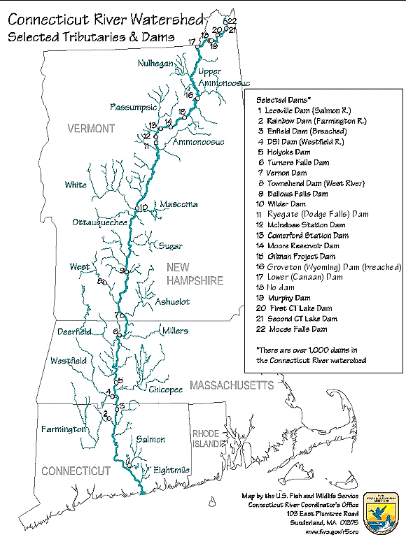
- Connecticut RiverConnecticut RiverThe Connecticut River is the largest and longest river in New England, and also an American Heritage River. It flows roughly south, starting from the Fourth Connecticut Lake in New Hampshire. After flowing through the remaining Connecticut Lakes and Lake Francis, it defines the border between the...
- Farmington River (CT)
- East Branch Farmington River (CT)
- Hubbard RiverHubbard RiverThe Hubbard River, long, is part of the Farmington River watershed. It is a main feature of Granville State Forest where it drops in . It is named for Samuel Hubbard, the English colonist who first came to the area in 1749...
- Hubbard River
- West Branch Farmington River
- Clam River
- Buck River
- Fall River (Farmington River)
- Clam River
- East Branch Farmington River (CT)
- Scantic RiverScantic RiverThe Scantic River is a river that flows through the states of Massachusetts and Connecticut and is tributary to the Connecticut River.The Scantic River's tributaries rise in the towns of Hampden, Wilbraham, East Longmeadow and Monson in Massachusetts, and in Stafford and Somers, Connecticut,...
- Farmington River (CT)
-
- Westfield RiverWestfield RiverThe Westfield River in Metropolitan Springfield, Massachusetts, is a major tributary of the Connecticut River in Hampden County, Massachusetts. The Westfield River has four major tributary branches that confluence in the City of Westfield, for which the river is named...
- Great Brook
- Little River (Westfield River, South)
- West Branch Westfield River
- Middle Branch Westfield River
- Little River (Westfield River, North)
- Swift River
- North Branch Swift River
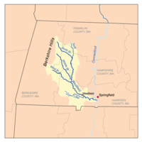
- Mill River (Springfield, Massachusetts)Mill River (Springfield, Massachusetts)The Mill River is a long tributary of the Connecticut River in Springfield, Massachusetts. It flows from Watershops Pond to its confluence with the Connecticut River. It is referred to as "The Miracle Mile" in a 2009 master's thesis that outlines possibilities for reclaiming the river's mouth as...
- North Branch Mill River
- South Branch Mill River
- Chicopee RiverChicopee RiverThe Chicopee River is an tributary of the Connecticut River in Metropolitan Springfield, Massachusetts, known for fast-moving water and its extraordinarily large basin: the Connecticut River's largest tributary basin...
- Quaboag RiverQuaboag RiverThe Quaboag River is a river in Massachusetts that heads at Quaboag Pond in Brookfield at an elevation of above sea level. It flows west to the village of Three Rivers, Massachusetts, at an elevation of .-History:...
- East Brookfield RiverEast Brookfield RiverThe East Brookfield River is a river in Massachusetts that heads at Lake Lashaway in East Brookfield at an elevation of above sea level. It continues to Quaboag Pond, at an elevation of .-History:...
- Sevenmile RiverSeven Mile River (East Brookfield River)The Seven Mile River or Sevenmile River is a stream in central Massachusetts. It heads at Browning Pond, at the Oakham and Spencer border, and travels south through Spencer, following a short distance from State Route 31...
- Cranberry RiverCranberry River (Massachusetts)The Cranberry River is a river in central Massachusetts that is part of the Chicopee River Watershed. It rises in Cranberry Meadow Pond in Spencer, Massachusetts, and flows northward for to its confluence with the Sevenmile River southwest of Spencer....
- Cranberry River
- Fivemile River
- Sevenmile River
- East Brookfield River
- Ware RiverWare RiverThe Ware River is a river in central Massachusetts. It has two forks, the longest of which begins near Hubbardston, Massachusetts...
- Swift River
- Quabbin ReservoirQuabbin ReservoirThe Quabbin Reservoir is the largest inland body of water in the Commonwealth of Massachusetts and was built between 1930 and 1939. Today along with the Wachusett Reservoir, it is the primary water supply for Boston, some to the east, as well as 40 other communities in Greater Boston...
- West Branch Swift River
- East Branch Swift River
- East Branch Fever Brook
- West Branch Fever Brook
- Middle Branch Swift River
- Quabbin Reservoir
- Prince River
- Burnshirt RiverBurnshirt RiverThe Burnshirt River is a stream in Worcester County, Massachusetts. It is a tributary of the Ware River, draining ultimately into the Connecticut River and thence the Long Island Sound....
- East Branch Ware River
- West Branch Ware River
- Swift River
- Quaboag River
- Stony Brook
- Manhan RiverManhan RiverThe Manhan River is a river in western Massachusetts. It is a tributary of the Connecticut River.The river begins near the boundary between the towns of Huntington and Westhampton, Massachusetts, and flows southeast to White Reservoir and then Tighe Carmody Reservoir in Southampton...
- North Branch Manhan River
- Mill River (Northampton, Massachusetts)
- East Branch Mill River
- West Branch Mill River
- Fort River
- Mill River (Hatfield, Massachusetts)
- Mill River (Hadley, Massachusetts)
- Sawmill River
- Deerfield RiverDeerfield RiverDeerfield River is a river that runs for from southern Vermont through northwestern Massachusetts to the Connecticut River. The Deerfield was historically influential in the settlement of western Franklin County, Massachusetts, and its namesake town...
- Green River (Deerfield River)
- South River
- Bear River
- North RiverNorth River (Deerfield River)The North River is a river in western Massachusetts, the United States.It is formed by the confluence of the West Branch and the East Branch of the North River in the town of Colrain, Massachusetts. The river is a tributary of the Deerfield River, joining it just north of the village of...
- East Branch North River
- West Branch North River
- Chickley River
- Cold River
- Green River (Cold River)
- Fall River (Connecticut River)
- Millers RiverMillers RiverThe Millers River is a river in northern Massachusetts, originating in Ashburnham and joining the Connecticut River just downstream from Millers Falls, Massachusetts...
- Tully River
- East Branch Tully River
- West Branch Tully River
- Otter River
- Priest Brook
- North Branch Millers RiverNorth Branch Millers RiverThe North Branch of the Millers River is a river in southwestern New Hampshire and northern Massachusetts in the United States. It is a tributary of the Millers River, which flows west to the Connecticut River, which in turn flows south to Long Island Sound, an arm of the Atlantic Ocean.The North...
- Tully River
- Westfield River
- Housatonic RiverHousatonic RiverThe Housatonic River is a river, approximately long, in western Massachusetts and western Connecticut in the United States. It flows south to southeast, and drains about of southwestern New England into Long Island Sound...
- Blackberry River (CT)
- Whiting River
- Konkapot RiverKonkapot RiverThe Konkapot River is a river in southwestern Massachusetts and northern Connecticut. It is a tributary of the Housatonic River, not to be confused with the smaller Konkapot Brook in Stockbridge ....
- Umpachene RiverUmpachene RiverThe Umpachene River is an tributary of the Housatonic River in New Marlborough, Massachusetts.The river rises from Harmon Pond and various wetlands, and flows generally westward to join the Konkapot River. A waterfall at their confluence, Umpachene Falls, is the site of a small town park with...
- Umpachene River
- Green River
- Williams River
- Hop Brook
- Mad River
- West Branch Housatonic River
- Southwest Branch Housatonic River
- East Branch Housatonic River
- Blackberry River (CT)
New York HarborNew York HarborNew York Harbor refers to the waterways of the estuary near the mouth of the Hudson River that empty into New York Bay. It is one of the largest natural harbors in the world. Although the U.S. Board of Geographic Names does not use the term, New York Harbor has important historical, governmental,...
- Hudson River (NY)
- Kinderhook CreekKinderhook CreekKinderhook Creek is a tributary to Stockport Creek, an inlet of the Hudson River in the United States. From its source in Hancock, Massachusetts, the creek runs southwest through the Taconic Mountains into Rensselaer County, New York, and then into Columbia County...
- Hoosic RiverHoosic RiverThe Hoosic River, also known as the Hoosac, the Hoosick and the Hoosuck , is a tributary of the Hudson River in the northeastern United States. The different spellings are the result of varying transliterations of the river's original Algonquian name...
- Green River
- North Branch Hoosic River
- Kinderhook Creek
External links
- "Assessment Data for the State of Massachusetts Year 2006", Environmental Protection Agency.