

Assonet River
Encyclopedia
Bristol County, Massachusetts
-Demographics:As of the census of 2000, there were 534,678 people, 205,411 households, and 140,706 families residing in the county. The population density was 962 people per square mile . There were 216,918 housing units at an average density of 390 per square mile...
. It flows 7.4 miles (11.9 km) in a westerly direction through Freetown
Freetown, Massachusetts
Freetown is a town in Bristol County, Massachusetts, United States. The population was 8,870 at the 2010 census.Freetown is one of the oldest communities in the United States, having been settled by the Pilgrims and their descendants in the latter half of the 17th century. The town once included...
and joins the Taunton River
Taunton River
The Taunton River , is a river in southeastern Massachusetts in the United States. It arises from the confluence of the Town River and Matfield River, in the town of Bridgewater...
near Assonet Neck in Berkley, Massachusetts
Berkley, Massachusetts
Berkley is a town in Bristol County, Massachusetts, United States. The population was 5,749 at the 2000 census, making it the least populated town in the county.-Geography:...
.
Description
The Assonet River is formed from the Cedar Swamp RiverCedar Swamp River
The Cedar Swamp River is a small river in Lakeville, Massachusetts that flows in a northwesterly direction through the western part of the town to where it forms the Assonet River near the Freetown line, just south of the village of Myricks...
near the border of Freetown
Freetown, Massachusetts
Freetown is a town in Bristol County, Massachusetts, United States. The population was 8,870 at the 2010 census.Freetown is one of the oldest communities in the United States, having been settled by the Pilgrims and their descendants in the latter half of the 17th century. The town once included...
and Lakeville
Lakeville, Massachusetts
Lakeville is a town in Plymouth County, Massachusetts, United States. The population was 9,821 at the 2000 census.For geographic and demographic information on the village of North Lakeville, please see the article North Lakeville, Massachusetts.-History:...
just south of Myricks
Myricks, Massachusetts
Myricks, Massachusetts, is an association community or populated place located in Bristol County, Massachusetts at latitude 41.831 and longitude -71.027. The elevation is 62 feet. Myricks appears on the Assonet U.S. Geological Survey Map....
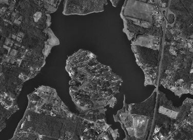
village. It is joined by Quaker Brook at Forge Pond. From this point it flows parallel to Route 79 through a series of small mill ponds. It becomes tidal near the Elm Street Bridge in Assonet village
Assonet, Massachusetts
Assonet is one of two villages in the town of Freetown, Massachusetts in Bristol County, Massachusetts, United States. An original part of the town, Assonet was settled in 1659 along with the city of Fall River, then a part of Freetown. It rests on the banks of the Assonet River...
where it widens and becomes Assonet Bay to the west of Route 24.
Assonet Bay contains several small coves fed by small streams including Payne's Cove (fed by Terry Brook from the south) and Shepherd's Cove located at its southwest end. The bay is also fed by Stacy's Creek from the north. Assonet Bay is surrounded by several small hills (drumlins). Past Shepherd's Cove the Assonet River narrows again for its last mile or so before joining the wide Taunton River
Taunton River
The Taunton River , is a river in southeastern Massachusetts in the United States. It arises from the confluence of the Town River and Matfield River, in the town of Bridgewater...
between Conspiracy Island
Conspiracy Island
Conspiracy Island is a privately owned tidal island situated in the Assonet River off Berkley, Massachusetts.According to the 2000 census, Conspiracy Island is uninhabited. In very low tides, the island is actually a peninsula, accessible across a sandy stretch of land connecting it to a nearby...
and Winslow Point. This portion of the river forms the town line between Berkley
Berkley, Massachusetts
Berkley is a town in Bristol County, Massachusetts, United States. The population was 5,749 at the 2000 census, making it the least populated town in the county.-Geography:...
and Freetown
Freetown, Massachusetts
Freetown is a town in Bristol County, Massachusetts, United States. The population was 8,870 at the 2010 census.Freetown is one of the oldest communities in the United States, having been settled by the Pilgrims and their descendants in the latter half of the 17th century. The town once included...
.
At its mouth, the Assonet River also forms Hathaway Cove in Assonet.
History
The Assonet River is a major river of southeastern Massachusetts, along with the Taunton RiverTaunton River
The Taunton River , is a river in southeastern Massachusetts in the United States. It arises from the confluence of the Town River and Matfield River, in the town of Bridgewater...
. Throughout the history of colonial and early America
Colonial America
The colonial history of the United States covers the history from the start of European settlement and especially the history of the thirteen colonies of Britain until they declared independence in 1776. In the late 16th century, England, France, Spain and the Netherlands launched major...
, the river and its tributaries provided the power to run grist mills and saw mills, and later the Crystal Springs Bleachery. It provided for a minor port, and is also a prime location for herring runs.
During the 18th century, the river played a part in the American Revolutionary War
American Revolutionary War
The American Revolutionary War , the American War of Independence, or simply the Revolutionary War, began as a war between the Kingdom of Great Britain and thirteen British colonies in North America, and ended in a global war between several European great powers.The war was the result of the...
. British ships travelled both it and the Taunton River when fighting in the colonies. Such attacks led to the Battle of Freetown
Battle of Freetown
The Mount Hope Bay raids were a series of military raids conducted by British troops during the American Revolutionary War against communities on the shores of Mount Hope Bay on May 25 and 30, 1778...
, as well as the burning of river-centered village centers.
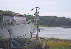
During the 19th century, fishing and cargo ships regularly used the Assonet River to reach their home port of Assonet, Massachusetts
Assonet, Massachusetts
Assonet is one of two villages in the town of Freetown, Massachusetts in Bristol County, Massachusetts, United States. An original part of the town, Assonet was settled in 1659 along with the city of Fall River, then a part of Freetown. It rests on the banks of the Assonet River...
. From these ports on Water Street and South Main Street were delivered products such as food
Food
Food is any substance consumed to provide nutritional support for the body. It is usually of plant or animal origin, and contains essential nutrients, such as carbohydrates, fats, proteins, vitamins, or minerals...
, dairy
Dairy
A dairy is a business enterprise established for the harvesting of animal milk—mostly from cows or goats, but also from buffalo, sheep, horses or camels —for human consumption. A dairy is typically located on a dedicated dairy farm or section of a multi-purpose farm that is concerned...
, lobster
American lobster
The American lobster, Homarus americanus, is a species of lobster found on the Atlantic coast of North America, chiefly from Labrador to New Jersey. Within North America, it is also known as the northern lobster or Maine lobster. It can reach a body length of , and a mass of over , making it the...
, fish
Fish
Fish are a paraphyletic group of organisms that consist of all gill-bearing aquatic vertebrate animals that lack limbs with digits. Included in this definition are the living hagfish, lampreys, and cartilaginous and bony fish, as well as various extinct related groups...
, lumber
Lumber
Lumber or timber is wood in any of its stages from felling through readiness for use as structural material for construction, or wood pulp for paper production....
, and for a span of time gun
Gun
A gun is a muzzle or breech-loaded projectile-firing weapon. There are various definitions depending on the nation and branch of service. A "gun" may be distinguished from other firearms in being a crew-served weapon such as a howitzer or mortar, as opposed to a small arm like a rifle or pistol,...
s. The N. R. Davis Gun Factory, located on Water Street adjacent to the river, supplied many weapons to forces in the Civil War
American Civil War
The American Civil War was a civil war fought in the United States of America. In response to the election of Abraham Lincoln as President of the United States, 11 southern slave states declared their secession from the United States and formed the Confederate States of America ; the other 25...
.
In the 20th century, the river continued to see its share of action, but only briefly. The last ship to sail from Assonet set out in 1902. Small bootlegging
Rum-running
Rum-running, also known as bootlegging, is the illegal business of transporting alcoholic beverages where such transportation is forbidden by law...
operations used the river sporadically. The Green Dragon Tavern was torn down in the 1930s, and the Town of Freetown
Freetown, Massachusetts
Freetown is a town in Bristol County, Massachusetts, United States. The population was 8,870 at the 2010 census.Freetown is one of the oldest communities in the United States, having been settled by the Pilgrims and their descendants in the latter half of the 17th century. The town once included...
constructed its bandstand on the riverside site, providing a wonderful greenspace. The gun factory burned in 1925, and the bleachery followed suit in 1955, essentially bringing the commercial life of the river to a close.
Assonet Bay Shores, a former summer community, is a peninsula formed by Assonet Bay, Payne Cove, and Shepherd's Cove. It was first settled early in Assonet's history, with this major development following in the early 1960s. Across Shepherd's Cove is an abundance of higher-end homes, proving that the river has found new life as a beautiful backdrop for rural life.
See also
- List of crossings of the Assonet River
- List of Massachusetts rivers
- Taunton River WatershedTaunton River Watershedright|thumb|200px|An USGS map of the Taunton River WatershedThe Taunton River watershed or Taunton River basin is made up of of rivers, lakes, ponds, streams, and wetlands in southeastern Massachusetts, USA. It is the second largest watershed in the state...