

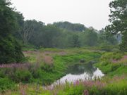
Town River
Encyclopedia
Plymouth County, Massachusetts
Plymouth County is a county located in the U.S. state of Massachusetts. As of 2010, the population was 494,919. Its county seats are Plymouth and Brockton...
, Massachusetts
Massachusetts
The Commonwealth of Massachusetts is a state in the New England region of the northeastern United States of America. It is bordered by Rhode Island and Connecticut to the south, New York to the west, and Vermont and New Hampshire to the north; at its east lies the Atlantic Ocean. As of the 2010...
. It flows 10.6 miles (17.1 km) from the northeast end of Lake Nippenicket
Lake Nippenicket
Lake Nippenicket, known locally as The Nip, is a freshwater lake in the town of Bridgewater, Massachusetts, and immediately adjacent to Raynham, Massachusetts. The lake borders a tiny portion of Route 104, and is near the junction of I-495 and Route 24...
in the town of Bridgewater
Bridgewater, Massachusetts
For geographic and demographic information on the census-designated place Bridgewater, please see the article Bridgewater , Massachusetts.The Town of Bridgewater is a city in Plymouth County, Massachusetts, United States, 28 miles south of Boston. At the 2000 Census, the population was 25,185...
, flowing easterly through West Bridgewater
West Bridgewater, Massachusetts
West Bridgewater is a town in Plymouth County, Massachusetts, United States. The population was 6,634 at the 2000 census.- History :West Bridgewater was first settled in 1651 as a part of Olde Bridgewater...
, then south back into Bridgewater where it joins with the Matfield River
Matfield River
The Matfield River is a river in Plymouth County, Massachusetts. It flows south through the town of East Bridgewater to a confluence with the Town River, forming the Taunton River. The Matfield River, where it flows through the historic village of Elmwood and flows under Route 18, is commonly...
to form the Taunton River
Taunton River
The Taunton River , is a river in southeastern Massachusetts in the United States. It arises from the confluence of the Town River and Matfield River, in the town of Bridgewater...
.
Tributaries
- Lake NippenicketLake NippenicketLake Nippenicket, known locally as The Nip, is a freshwater lake in the town of Bridgewater, Massachusetts, and immediately adjacent to Raynham, Massachusetts. The lake borders a tiny portion of Route 104, and is near the junction of I-495 and Route 24...
- Hockomock SwampHockomock SwampThe Hockomock Swamp is a vast wetland encompassing much of the northern part of southeastern Massachusetts. This land is considered the second largest wetland in the state...
- Hockomock RiverHockomock RiverThe Hockomock River is a stream in West Bridgewater, Massachusetts. It is a tributary of the Town River.Hockomock is said to mean "Place where Spirits Dwell" in the Wampanoag language. The river arises in the Hockomock Swamp, and flows south to its confluence with the Town River which eventually...
- Onemile Brook
- Meadow Brook
- South Brook
Crossings
In West Bridgewater- Route 24
- Scotland Street
- Forest Street
- South Street
- Arch
- South Main Street (Route 28)
In Bridgewater
- High Street
- Oak Street
- Railroad
- Broad Street (Route 18)
- Hayward Street