

Weymouth Back River
Encyclopedia
Tidal river
A tidal river is a river, or more typically a stretch of a river, whose flow and level is influenced by tides. An example of a tidal river is the portion of the Connecticut River flowing from Windsor Locks, Connecticut, to the Atlantic Ocean. The Brisbane River, which flows into the Pacific Ocean...
in Hingham
Hingham, Massachusetts
Hingham is a town in northern Plymouth County on the South Shore of the U.S. state of Massachusetts and suburb in Greater Boston. The United States Census Bureau 2008 estimated population was 22,561...
and Weymouth, Massachusetts
Weymouth, Massachusetts
The Town of Weymouth is a city in Norfolk County, Massachusetts, United States. As of the 2010 census, Weymouth had a total population of 53,743. Despite its city status, it is formally known as the Town of Weymouth...
, about 10 miles (16.1 km) south of Boston
Boston
Boston is the capital of and largest city in Massachusetts, and is one of the oldest cities in the United States. The largest city in New England, Boston is regarded as the unofficial "Capital of New England" for its economic and cultural impact on the entire New England region. The city proper had...
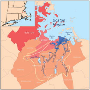
. It arises from a number of tributaries in ponds and swamps, most notably Whitman's Pond, flows northward, and empties into Hingham Bay
Hingham Bay
Hingham Bay is the easternmost of the three small bays of outer Boston Harbor, part of Massachusetts Bay and forming the western shoreline of the town of Hull and the northern shoreline of Hingham in the United States state of Massachusetts. It lies east of Quincy Bay and is met at the southwest by...
(just south of Grape Island
Grape Island (Massachusetts)
Grape Island is an island in the Hingham Bay area of the Boston Harbor Islands National Recreation Area. The island is part of the territory of the town of Weymouth, Massachusetts. The island has a permanent size of , plus an intertidal zone of a further , and is composed of two drumlins, reaching...
and Slate Island).
History
The river formed as the last glacierGlacier
A glacier is a large persistent body of ice that forms where the accumulation of snow exceeds its ablation over many years, often centuries. At least 0.1 km² in area and 50 m thick, but often much larger, a glacier slowly deforms and flows due to stresses induced by its weight...
retreated from New England
New England
New England is a region in the northeastern corner of the United States consisting of the six states of Maine, New Hampshire, Vermont, Massachusetts, Rhode Island, and Connecticut...
about 12,000 years ago, when glacial melting increased the sea level and low−lying coastal areas were flooded. Its river herring runs were an important source of food to both native and European inhabitants, and it served as the Hingham-Weymouth boundary as early as 1635. Various industries have used the river, including a steel mill, wool factory, and fertilizer factory. During the 20th century, the Army Corps of Engineers conducted two projects on the river, completed in 1912 and 1943. The first created a large channel (12 feet deep, 200 feet (61 m) wide) from the river mouth to a former fertilizer company wharf, about one mile (1.6 km) upstream. The second deepened the channel to 15 feet (4.6 m).
Ecology
The river is part of the Weymouth Back River Area of Critical Environmental Concern (about 950 acres), of which some 180 acre (0.7284348 km²) are tidal waters. It is home to about 150 species of birds in its salt marshSalt marsh
A salt marsh is an environment in the upper coastal intertidal zone between land and salt water or brackish water, it is dominated by dense stands of halophytic plants such as herbs, grasses, or low shrubs. These plants are terrestrial in origin and are essential to the stability of the salt marsh...
es and is bounded by wooded wildlife preserves.
A sizeable herring run was an important food source for Weymouth's citizens as documented in town records as early as 1648. At Iron Hill Park off Iron Hill Street, Whitman's Pond was dammed to turn the machines which processed the natural bog iron for the Weymouth Iron Works. Later, the Commonwealth of Massachusetts installed a herring ladder to allow the herring to bypass the dam on their spawning runs. Historically the herring ran to Whitman's Pond, and beyond up Mill River and Swamp River, to Great Pond. River herring commonly refers to two species, Blueback herring
Blueback herring
The blueback herring is an anadromous species of herring from the east coast of North America from Cape Breton, Nova Scotia to the St. John’s River in Florida. Blueback herring form schools and are believed to migrate offshore to overwinter near the bottom.This fish has, in the past, been used as...
(Alosa aestivalis) and alewife
Alewife
The alewife is a species of herring. There are anadromous and landlocked forms. The landlocked form is also called a sawbelly or mooneye...
((Alosa pseudoharengus)). Today, river herring and smelt run up the river to spawn.
Several nesting platforms were constructed and are in use by the osprey
Osprey
The Osprey , sometimes known as the sea hawk or fish eagle, is a diurnal, fish-eating bird of prey. It is a large raptor, reaching more than in length and across the wings...
, or fish hawk, (Pandion haliaetus), which has white under parts and a wingspread of 5 to 6 ft (152 to 183 cm). It feeds almost exclusively on live fish including flounder, herring and perch, and is usually seen hovering over the water, into which it plunges feet first to grasp its prey.
Recreation
The Weymouth back River offers an outstanding canoe and kayak paddling resource within the Greater Boston Metropolitan Area. Harbormasters from Hingham and Weymouth established the river as a no-wake zone, with no water-skiing and no personal watercraft allowed south of the Route 3A Bridge. A number of parks and reservations line the river's shores, including Abigail Adams Park, Stodder's Neck, Great Esker ParkGreat Esker Park
Great Esker Park is a geological formation along the Weymouth Back River in Weymouth, Massachusetts.This area was formed by a glacier 12,000 years ago...
(Weymouth), and Bare Cove Park (Hingham).
Bicycling and hiking is popular along both sides of the Back River on the Back River Trail which connects multiple sites of environmental and historical interest.