
Canoe River
Encyclopedia
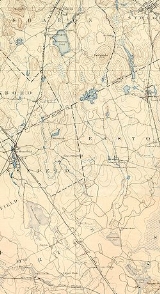
_map.jpg)
Massachusetts
The Commonwealth of Massachusetts is a state in the New England region of the northeastern United States of America. It is bordered by Rhode Island and Connecticut to the south, New York to the west, and Vermont and New Hampshire to the north; at its east lies the Atlantic Ocean. As of the 2010...
. It is 14.4 miles (23.2 km) long and part of the Taunton River
Taunton River
The Taunton River , is a river in southeastern Massachusetts in the United States. It arises from the confluence of the Town River and Matfield River, in the town of Bridgewater...
watershed.
The Canoe River arises from headwaters near Lake Massapoag
Lake Massapoag
Lake Massapoag is a , natural, springfed lake located in Sharon, Massachusetts. The name Massapoag is Algonquin, meaning "large water".Massapoag is the headwater of the Canoe River, which flows south to join the Taunton River and empty into Narragansett Bay...
in Sharon
Sharon, Massachusetts
Sharon is a town in Norfolk County, Massachusetts, United States. The population was 17,612 at the 2010 census. Sharon is part of Greater Boston, about 17 miles southwest of downtown Boston....
, and meanders generally southwards through the towns of Sharon, Foxborough
Foxborough, Massachusetts
-Demographics:As of the census of 2000, there were 16,246 people, 6,141 households, and 4,396 families residing in the town. The population density was 809.1 people per square mile . There were 6,299 housing units at an average density of 313.7 per square mile...
, Mansfield
Mansfield, Massachusetts
Mansfield is a town in Bristol County, Massachusetts, United States. As of the United States 2010 Census, the town population is 23,184. Mansfield is in the south-southwest suburbs of Boston and is also close to Providence, Rhode Island....
, and Easton
Easton, Massachusetts
Easton is a town in Bristol County, Massachusetts, United States. The population was 23,112 at the 2010 census.Easton is governed by an elected committee of selectmen and a town administrator.- History :...
to empty into Winnecunnet Pond
Winnecunnet Pond
Winnecunnet Pond or Winneconnet Pond or Winnecunnett Pond, very often called Lake Winnecunnet or Lake Winneconnet or Lake Winnecunnett although it is a pond rather than a lake, is a body of water in Norton, Massachusetts, USA....
in Norton
Norton, Massachusetts
Norton is a town in Bristol County, Massachusetts, United States, and contains the village of Norton Center. The population was 18,036 at the 2000 census...
.
Winnecunnet Pond
Winnecunnet Pond
Winnecunnet Pond or Winneconnet Pond or Winnecunnett Pond, very often called Lake Winnecunnet or Lake Winneconnet or Lake Winnecunnett although it is a pond rather than a lake, is a body of water in Norton, Massachusetts, USA....
is emptied by the Snake River
Snake River (Massachusetts)
The Snake River is a small river in Bristol County, Massachusetts. It flows fromWinnecunnet Pond to Lake Sabbatia in the northern part of Taunton, Massachusetts....
which flows into Lake Sabbatia
Lake Sabbatia
Lake Sabbatia is a freshwater lake in Taunton, Massachusetts, near Watson Pond State Park. The lake is where Mill River begins and the Snake River ends. It is the largest lake in the city of Taunton and the most popularly used. There are several coves and an island within the lake. Parts of its...
which was formed by damming the Mill River which joins the Taunton River
Taunton River
The Taunton River , is a river in southeastern Massachusetts in the United States. It arises from the confluence of the Town River and Matfield River, in the town of Bridgewater...
and ultimately empties into Narragansett Bay
Narragansett Bay
Narragansett Bay is a bay and estuary on the north side of Rhode Island Sound. Covering 147 mi2 , the Bay forms New England's largest estuary, which functions as an expansive natural harbor, and includes a small archipelago...
.
The river provides drinking water for about 50,000 people in the region who receive their water from its aquifer
Aquifer
An aquifer is a wet underground layer of water-bearing permeable rock or unconsolidated materials from which groundwater can be usefully extracted using a water well. The study of water flow in aquifers and the characterization of aquifers is called hydrogeology...
. It has been designated a Sole Source Aquifer and since 1991, an Area of Critical Environmental Concern
Area of Critical Environmental Concern (Massachusetts)
The Massachusetts Area of Critical Environmental Concern Program is a list of state-designated places within the Commonwealth that receive special attention due to their natural and cultural resources. The program was established in 1975 and includes a list of thirty ACECs covering over...
by the Commonwealth of Massachusetts.