

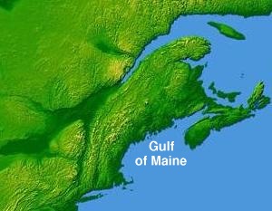
Gulf of Maine
Encyclopedia
Headlands and bays
Headlands and bays are two related features of the coastal environment.- Geology and geography :Headlands and bays are often found on the same coastline. A bay is surrounded by land on three sides, whereas a headland is surrounded by water on three sides. Headlands are characterized by high,...
of the Atlantic Ocean
Atlantic Ocean
The Atlantic Ocean is the second-largest of the world's oceanic divisions. With a total area of about , it covers approximately 20% of the Earth's surface and about 26% of its water surface area...
on the east coast of North America
North America
North America is a continent wholly within the Northern Hemisphere and almost wholly within the Western Hemisphere. It is also considered a northern subcontinent of the Americas...
.
It is delineated by Cape Cod
Cape Cod
Cape Cod, often referred to locally as simply the Cape, is a cape in the easternmost portion of the state of Massachusetts, in the Northeastern United States...
at the eastern tip of Massachusetts
Massachusetts
The Commonwealth of Massachusetts is a state in the New England region of the northeastern United States of America. It is bordered by Rhode Island and Connecticut to the south, New York to the west, and Vermont and New Hampshire to the north; at its east lies the Atlantic Ocean. As of the 2010...
in the southwest and Cape Sable at the southern tip of Nova Scotia
Nova Scotia
Nova Scotia is one of Canada's three Maritime provinces and is the most populous province in Atlantic Canada. The name of the province is Latin for "New Scotland," but "Nova Scotia" is the recognized, English-language name of the province. The provincial capital is Halifax. Nova Scotia is the...
in the northeast. It includes the entire coastlines of the U.S. state
U.S. state
A U.S. state is any one of the 50 federated states of the United States of America that share sovereignty with the federal government. Because of this shared sovereignty, an American is a citizen both of the federal entity and of his or her state of domicile. Four states use the official title of...
s of New Hampshire
New Hampshire
New Hampshire is a state in the New England region of the northeastern United States of America. The state was named after the southern English county of Hampshire. It is bordered by Massachusetts to the south, Vermont to the west, Maine and the Atlantic Ocean to the east, and the Canadian...
and Maine
Maine
Maine is a state in the New England region of the northeastern United States, bordered by the Atlantic Ocean to the east and south, New Hampshire to the west, and the Canadian provinces of Quebec to the northwest and New Brunswick to the northeast. Maine is both the northernmost and easternmost...
, as well as Massachusetts
Massachusetts
The Commonwealth of Massachusetts is a state in the New England region of the northeastern United States of America. It is bordered by Rhode Island and Connecticut to the south, New York to the west, and Vermont and New Hampshire to the north; at its east lies the Atlantic Ocean. As of the 2010...
north of Cape Cod, and the southern and western coastlines of the Canadian provinces of New Brunswick
New Brunswick
New Brunswick is one of Canada's three Maritime provinces and is the only province in the federation that is constitutionally bilingual . The provincial capital is Fredericton and Saint John is the most populous city. Greater Moncton is the largest Census Metropolitan Area...
and Nova Scotia
Nova Scotia
Nova Scotia is one of Canada's three Maritime provinces and is the most populous province in Atlantic Canada. The name of the province is Latin for "New Scotland," but "Nova Scotia" is the recognized, English-language name of the province. The provincial capital is Halifax. Nova Scotia is the...
respectively.
Both Massachusetts Bay
Massachusetts Bay
The Massachusetts Bay, also called Mass Bay, is one of the largest bays of the Atlantic Ocean which forms the distinctive shape of the coastline of the U.S. state of Massachusetts. Its waters extend 65 miles into the Atlantic Ocean. Massachusetts Bay includes the Boston Harbor, Dorchester Bay,...
and the Bay of Fundy
Bay of Fundy
The Bay of Fundy is a bay on the Atlantic coast of North America, on the northeast end of the Gulf of Maine between the Canadian provinces of New Brunswick and Nova Scotia, with a small portion touching the U.S. state of Maine...
are included within the Gulf of Maine system. As such, the Gulf of Maine is also home to the highest tidal variations on the planet (see Bay of Fundy
Bay of Fundy
The Bay of Fundy is a bay on the Atlantic coast of North America, on the northeast end of the Gulf of Maine between the Canadian provinces of New Brunswick and Nova Scotia, with a small portion touching the U.S. state of Maine...
for further information).
Geographic features and biological importance
The coastline of the Gulf of Maine is predominantly rocky and scenic; the only significant coastal developments are located in the Boston, PortsmouthPortsmouth, New Hampshire
Portsmouth is a city in Rockingham County, New Hampshire in the United States. It is the largest city but only the fourth-largest community in the county, with a population of 21,233 at the 2010 census...
, Portland
Portland, Maine
Portland is the largest city in Maine and is the county seat of Cumberland County. The 2010 city population was 66,194, growing 3 percent since the census of 2000...
and Saint John
Saint John, New Brunswick
City of Saint John , or commonly Saint John, is the largest city in the province of New Brunswick, and the first incorporated city in Canada. The city is situated along the north shore of the Bay of Fundy at the mouth of the Saint John River. In 2006 the city proper had a population of 74,043...
metropolitan areas. The effects of glaciation are responsible for stripping sedimentary soil away from the coastline, therefore the gulf lacks the sandy beaches found to the south along the Eastern Seaboard
Eastern seaboard
An Eastern seaboard can mean any easternmost part of a continent, or its countries, states and/or cities.Eastern seaboard may also refer to:* East Coast of Australia* East Coast of the United States* Eastern Seaboard of Thailand-See also:...
. The underwater features of the seabed sculptured during the lower sea levels of the ice age
Ice age
An ice age or, more precisely, glacial age, is a generic geological period of long-term reduction in the temperature of the Earth's surface and atmosphere, resulting in the presence or expansion of continental ice sheets, polar ice sheets and alpine glaciers...
s make the gulf a semi-enclosed sea bounded to the south and east by underwater banks. Georges Bank
Georges Bank
Georges Bank is a large elevated area of the sea floor which separates the Gulf of Maine from the Atlantic Ocean and is situated between Cape Cod, Massachusetts and Cape Sable Island, Nova Scotia ....
in particular, on its southern end, protects the Gulf of Maine waters from the Gulf Stream
Gulf Stream
The Gulf Stream, together with its northern extension towards Europe, the North Atlantic Drift, is a powerful, warm, and swift Atlantic ocean current that originates at the tip of Florida, and follows the eastern coastlines of the United States and Newfoundland before crossing the Atlantic Ocean...
. Gulf of Maine waters are more strongly influenced by the Labrador Current
Labrador Current
The Labrador Current is a cold current in the North Atlantic Ocean which flows from the Arctic Ocean south along the coast of Labrador and passes around Newfoundland, continuing south along the east coast of Nova Scotia...
, making the gulf waters significantly colder and more nutrient-rich than those found to the south. Undersea valleys in the central basin can reach depths of 1,500 feet (500 m) while undersea mountains rise up 800 feet (266 m) from the sea floor, almost reaching the surface in some locations, or even exceeding it, creating islands.
There are three major basins contained within the Gulf of Maine: Wilkinson Basin to the west, Jordan Basin in the northeast, and Georges Basin in the south, which are isolated from each other beneath the 650 foot (200 m) isobath. Georges Basin, just north of Georges Bank, is the deepest of the three at just over 1200 feet (370 m) and generates a pocket at the end of the Northeast Channel, a deep fissure between Georges Bank and Browns Bank, the southwestern edge of the Nova Scotian Shelf. The Northeast Channel is the major channel between the Gulf and the rest of the Northwest Atlantic. A secondary, shallower connection to the rest of the Atlantic is the Great South Channel, located between Georges Bank and the Nantucket Shoals.
Gulf of Maine watershed
The watershed of the gulf encompasses an area of 69,115 miles² (179,008 km²), including all of Maine, 70% of New Hampshire, 56% of New Brunswick, 41% of Massachusetts, and 36% of Nova Scotia. The watershed also includes a small southern portion (less than 1%) of the Canadian province of QuebecQuebec
Quebec or is a province in east-central Canada. It is the only Canadian province with a predominantly French-speaking population and the only one whose sole official language is French at the provincial level....
. Significant rivers that drain into the Gulf include, from east to west, the Annapolis
Annapolis River
The Annapolis River is a Canadian river located in Nova Scotia's Annapolis Valley.-Geography:Measuring 120 kilometres in length, the river flows southwest through the western part of the valley from its source in Caribou Bog near the villages of Aylesford and Berwick in western Kings County, to...
, Shubenacadie
Shubenacadie River
The Shubenacadie River is a river in Nova Scotia, Canada.It has a meander length of approximately 72 km from its source at Shubenacadie Grand Lake to its mouth at the historic seaport village of Maitland on Cobequid Bay, site of the building of the William D. Lawrence, the largest wooden ship ever...
, Salmon
Salmon River (Nova Scotia)
The Salmon River is a Canadian river in central Nova Scotia's Colchester County.Rising in the Cobequid Hills in the central-northeastern part of the county, the river descends through a broad glacial valley at the head of Cobequid Bay, the eastern extremity of the Bay of Fundy...
, Petitcodiac
Petitcodiac River
The Petitcodiac River is a Canadian river in south-eastern New Brunswick. The river runs about through the province's Westmorland, Albert, and Kings counties, draining a watershed area of about . The region around the river features valleys, ridges, and rolling hills, and is home to a diverse...
, St. John, Magaguadavic
Magaguadavic River
The Magaguadavic River is a historic Canadian river located in the province of New Brunswick.The name "Magaguadavic" is a Maliseet / Passamaquoddy term that is believed to translate into "River of Eels". It is most commonly pronounced "mack-uh-day-vick" or "mack-uh-day-vee".-Description:With a...
, St. Croix
St. Croix River (Maine-New Brunswick)
The St. Croix River is a river in northeastern North America, in length, that forms part of the Canada – United States border between Maine and New Brunswick . The river rises in the Chiputneticook Lakes and flows south and southeast, between Calais and St. Stephen...
, Penobscot
Penobscot River
The Penobscot River is a river in the U.S. state of Maine. Including the river's West Branch and South Branch increases the Penobscot's length to , making it the second longest river system in Maine and the longest entirely in the state. Its drainage basin contains .It arises from four branches...
, Kennebec
Kennebec River
The Kennebec River is a river that is entirely within the U.S. state of Maine. It rises in Moosehead Lake in west-central Maine. The East and West Outlets join at Indian Pond and the river then flows southward...
, Saco
Saco River
The Saco River is a river in northeastern New Hampshire and southwestern Maine in the United States. It drains a rural area of of forests and farmlands west and southwest of Portland, emptying into the Atlantic Ocean at Saco Bay, from its source. It supplies drinking water to roughly 250,000...
, Piscataqua
Piscataqua River
The Piscataqua River, in the northeastern United States, is a long tidal estuary formed by the confluence of the Salmon Falls and Cocheco rivers...
, Merrimack
Merrimack River
The Merrimack River is a river in the northeastern United States. It rises at the confluence of the Pemigewasset and Winnipesaukee rivers in Franklin, New Hampshire, flows southward into Massachusetts, and then flows northeast until it empties into the Atlantic Ocean at Newburyport...
and Charles
Charles River
The Charles River is an long river that flows in an overall northeasterly direction in eastern Massachusetts, USA. From its source in Hopkinton, the river travels through 22 cities and towns until reaching the Atlantic Ocean at Boston...
rivers; the St. John and Penobscot having the greatest discharge.
The cold waters of the gulf make it one of the most productive marine environments in the North Atlantic, and it furnishes habitat for many diverse species including most notably the Atlantic herring
Atlantic herring
Atlantic herring is a fish in the family Clupeidae. It is one of the most abundant fish species on earth. Herring can be found on both sides of the Atlantic Ocean, congregating in large schools. They can grow up to in length and weigh more than...
(Clupea harengus) and the American lobster
American lobster
The American lobster, Homarus americanus, is a species of lobster found on the Atlantic coast of North America, chiefly from Labrador to New Jersey. Within North America, it is also known as the northern lobster or Maine lobster. It can reach a body length of , and a mass of over , making it the...
(Homarus americanus), which grows to famously large sizes in the gulf. The waters of the Gulf of Maine system, particularly at the boundary with the Bay of Fundy
Bay of Fundy
The Bay of Fundy is a bay on the Atlantic coast of North America, on the northeast end of the Gulf of Maine between the Canadian provinces of New Brunswick and Nova Scotia, with a small portion touching the U.S. state of Maine...
are also home to the summering grounds for many different whale
Whale
Whale is the common name for various marine mammals of the order Cetacea. The term whale sometimes refers to all cetaceans, but more often it excludes dolphins and porpoises, which belong to suborder Odontoceti . This suborder also includes the sperm whale, killer whale, pilot whale, and beluga...
species, most notably the highly endangered North Atlantic Right Whale
North Atlantic Right Whale
The North Atlantic right whale which means "good, or true, whale of the ice") is a baleen whale, one of three right whale species belonging to the genus Eubalaena, formerly classified as a single species. With only 400 in existence, North Atlantic right whales are among the most endangered whales...
.
History and political significance

Europe
Europe is, by convention, one of the world's seven continents. Comprising the westernmost peninsula of Eurasia, Europe is generally 'divided' from Asia to its east by the watershed divides of the Ural and Caucasus Mountains, the Ural River, the Caspian and Black Seas, and the waterways connecting...
made it an early destination for European colonization. French
France
The French Republic , The French Republic , The French Republic , (commonly known as France , is a unitary semi-presidential republic in Western Europe with several overseas territories and islands located on other continents and in the Indian, Pacific, and Atlantic oceans. Metropolitan France...
settlers founded a settlement on St. Croix Island in 1604. English
England
England is a country that is part of the United Kingdom. It shares land borders with Scotland to the north and Wales to the west; the Irish Sea is to the north west, the Celtic Sea to the south west, with the North Sea to the east and the English Channel to the south separating it from continental...
settlers founded the Popham Colony
Popham Colony
The Popham Colony was a short-lived English colonial settlement in North America that was founded in 1607 and located in the present-day town of Phippsburg, Maine near the mouth of the Kennebec River by the proprietary Virginia Company of Plymouth...
on an island in the Kennebec River in 1607, the same years as the Jamestown
Jamestown, Virginia
Jamestown was a settlement in the Colony of Virginia. Established by the Virginia Company of London as "James Fort" on May 14, 1607 , it was the first permanent English settlement in what is now the United States, following several earlier failed attempts, including the Lost Colony of Roanoke...
settlement, followed by the Plymouth Colony
Plymouth Colony
Plymouth Colony was an English colonial venture in North America from 1620 to 1691. The first settlement of the Plymouth Colony was at New Plymouth, a location previously surveyed and named by Captain John Smith. The settlement, which served as the capital of the colony, is today the modern town...
on the shores of Massachusetts Bay in 1620.
In the 1960s and 1970s there was a dispute between Canada and the United States over fishing and other resource rights in the Gulf of Maine, specifically the Georges Bank
Georges Bank
Georges Bank is a large elevated area of the sea floor which separates the Gulf of Maine from the Atlantic Ocean and is situated between Cape Cod, Massachusetts and Cape Sable Island, Nova Scotia ....
region. This dispute was taken to the International Court of Justice
International Court of Justice
The International Court of Justice is the primary judicial organ of the United Nations. It is based in the Peace Palace in The Hague, Netherlands...
, which delineated a maritime boundary
Maritime boundary
Maritime boundary is a conceptual means of division of the water surface of the planet into maritime areas that are defined through surrounding physical geography or by human geography. As such it usually includes areas of exclusive national rights over the mineral and biological resources,...
through the Gulf in 1984. Canada and the U.S. continue to disagree on the sovereignty of Machias Seal Island
Machias Seal Island
Machias Seal Island is an island located in the Gulf of Maine, approximately southeast from Cutler, Maine, and approximately southwest of Southwest Head, New Brunswick on Grand Manan Island. Machias Seal Island is located at and measures approximately in area. It is a neighbour to North Rock....
and the waters surrounding it in the northeastern part of the gulf. In recognition of the Gulf's importance to marine habitat, both nations currently maintain complementary embargoes against offshore oil and gas exploration activities on Georges Bank
Georges Bank
Georges Bank is a large elevated area of the sea floor which separates the Gulf of Maine from the Atlantic Ocean and is situated between Cape Cod, Massachusetts and Cape Sable Island, Nova Scotia ....
in the southern part of the gulf.