
Westport River
Encyclopedia
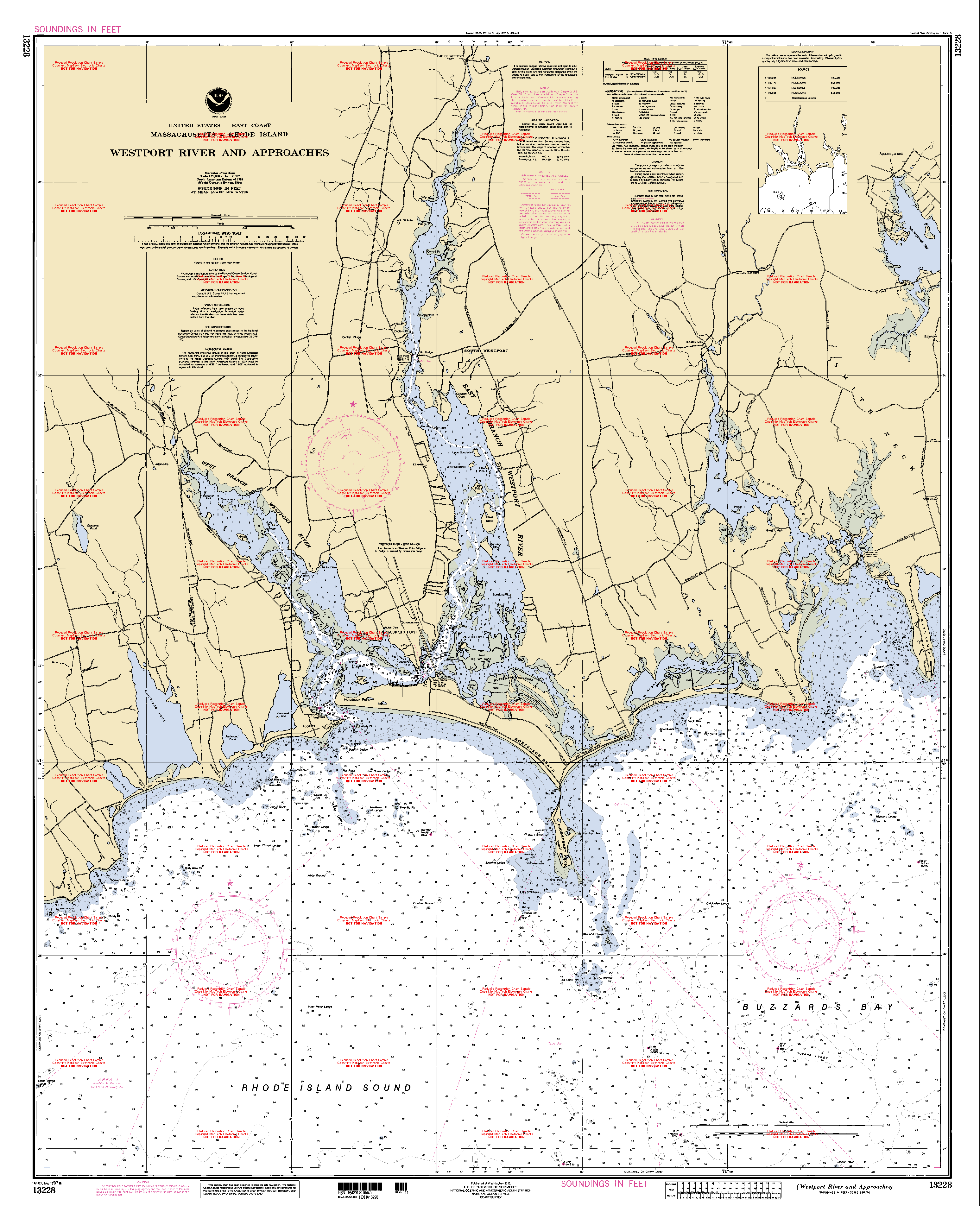
The Westport River lies between Narragansett Bay
Narragansett Bay
Narragansett Bay is a bay and estuary on the north side of Rhode Island Sound. Covering 147 mi2 , the Bay forms New England's largest estuary, which functions as an expansive natural harbor, and includes a small archipelago...
and Buzzards Bay
Buzzards Bay (bay)
Buzzards Bay is a bay of the Atlantic Ocean adjacent to the U.S. state of Massachusetts. It is approximately 28 miles long by 8 miles wide. It is a popular destination for fishing, boating, and tourism. Since 1914, Buzzards Bay has been connected to Cape Cod Bay by the Cape Cod Canal...
in Westport, Massachusetts
Westport, Massachusetts
Westport is a town in Bristol County, Massachusetts, United States. The population was 15,532 at the 2010 census.The village of North Westport lies in the town.- History :...
.
Description
The Westport River has two branches. The smaller West Branch is approximately 7 miles (11.3 km) long, rising from a confluence of brooks near the village of Adamsville, Rhode IslandAdamsville, Rhode Island
Adamsville, Rhode Island is a historic village in Little Compton, Rhode Island. It was first settled in 1675 around the time of King Phillip's War.-Historic Sites:...
. It flows in a southeastward direction, passing around several small islands before meeting Westport Harbor west of Westport Point. The West Branch separates the village of Acoaxet from the rest of the town; one has to pass into Rhode Island in order to reach the rest of Westport from there.
The larger East Branch is roughly 11.5 miles (18.5 km) long, rising at the town line of Westport and Dartmouth
Dartmouth, Massachusetts
Dartmouth is a town in Bristol County, Massachusetts, United States established in 1664. The population was 30,665 at the 2000 census. It is the location of the University of Massachusetts Dartmouth....
at Lake Noquochoke, which is fed mostly by the Copicut
Copicut River
The Copicut River, or Copecut River, is a stream in the U.S. state of Massachusetts.The river flows south from Copicut Reservoir , in Dartmouth and Fall River, to Cornell Pond near Hixville in Dartmouth...
and Shingle Island rivers. After a short length the river meets the Bread and Cheese Brook before reaching the Head of Westport village, where the river widens and deepens. From here the river continues southward, being fed by several brooks before an initial widening to between 100-400 yards at Widows Point. From Widows Point, the river flows due southward, crossing under the Hix Bridge before passing Gull Rock and then widening at Cadman's Neck to approximately a half mile wide. The river flows southward, with several larger islands dotting the path, before meeting the Horseneck Channel (which in turn leads to The Let) at Westport Point. The West Branch then flows under the Normand Edward Fontaine Bridge and into Westport Harbor.
Once in Westport Harbor, the combined branches bend around Horseneck Point across from The Knubble before flowing into Rhode Island Sound
Rhode Island Sound
Rhode Island Sound is a strait of water, off the coast of the state of Rhode Island at mouth of Narragansett Bay. It forms the eastern extension of Long Island Sound and opens out the Atlantic Ocean between Block Island and Martha's Vineyard....
, just west of Horseneck Beach State Reservation
Horseneck Beach State Reservation
The Horseneck Beach State Reservation is a large public state beach reservation on Westport River, Westport Harbor, Horseneck Channel, The Let, Rhode Island Sound, and Buzzards Bay, in the southern portion of the town of Westport, Massachusetts, USA....
and the point where Rhode Island Sound meets Buzzards Bay
Buzzards Bay
Buzzards Bay is a bay along the southern edge of Massachusetts in the United States. The name may also refer to:*Buzzards Bay, Massachusetts, a village in Bourne, Massachusetts*Buzzards Bay , the name of the horse that won the 2005 Santa Anita Derby...
.
Wildlife
The Westport River estuaryEstuary
An estuary is a partly enclosed coastal body of water with one or more rivers or streams flowing into it, and with a free connection to the open sea....
has long been known for its wildlife. Deer, coyotes, foxes, and turkeys can all be spotted at different times along the shore. Ospreys are very prevalent. There were 41 nesting sites confirmed in 1980. Now the population has spread to over 300 state wide, due to the Westport River estuary nesting program. MassWildlife continues to provide technical assistance to monitor a sample of the nesting population to determine productivity.