

List of Florida hurricanes (1950-1974)
Encyclopedia
_tracks.jpg)
Atlantic hurricane
North Atlantic tropical cyclones usually form in the northern hemisphere summer or fall. Tropical cyclones can be categorized by intensity. Tropical storms have one-minute maximum sustained winds of at least 39 mph , while hurricanes have one-minute maximum sustained exceeding 74 mph...
tropical
Tropical cyclone
A tropical cyclone is a storm system characterized by a large low-pressure center and numerous thunderstorms that produce strong winds and heavy rain. Tropical cyclones strengthen when water evaporated from the ocean is released as the saturated air rises, resulting in condensation of water vapor...
or subtropical cyclone
Subtropical cyclone
A subtropical cyclone is a weather system that has some characteristics of a tropical and an extratropical cyclone. As early as the 1950s, meteorologists were unclear whether they should be characterized as tropical or extratropical cyclones. They were officially recognized by the National...
s that affected the U.S. state
U.S. state
A U.S. state is any one of the 50 federated states of the United States of America that share sovereignty with the federal government. Because of this shared sovereignty, an American is a citizen both of the federal entity and of his or her state of domicile. Four states use the official title of...
of Florida
Florida
Florida is a state in the southeastern United States, located on the nation's Atlantic and Gulf coasts. It is bordered to the west by the Gulf of Mexico, to the north by Alabama and Georgia and to the east by the Atlantic Ocean. With a population of 18,801,310 as measured by the 2010 census, it...
. Collectively, tropical cyclones in Florida during the time period resulted in about $6.2 billion (2008 USD) in damage, primarily from Hurricanes Donna
Hurricane Donna
Hurricane Donna in the 1960 Atlantic hurricane season was a Cape Verde-type hurricane which moved across the Leeward Islands, Puerto Rico, Hispanola, Cuba, The Bahamas, and every state on the East Coast of the United States...
and Dora
Hurricane Dora
Hurricane Dora was the first tropical cyclone on record to make landfall over the extreme northeast coast of Florida. Dora was also the first storm to produce hurricane force winds to Jacksonville, Florida in the almost 80 years of record keeping. Dora killed five people and left over...
. Additionally, tropical cyclones in Florida were directly responsible for 93 fatalities during the period, as well as responsible for 23 indirect deaths. Several tropical cyclones produced over 20 inches (500 mm) of rainfall in the state, including Hurricane Easy
Hurricane Easy (1950)
Hurricane Easy was the fifth tropical storm, hurricane, and major hurricane of the 1950 Atlantic hurricane season. The hurricane developed in the western Caribbean Sea on September 1, and tracked northeastward. After crossing Cuba, the hurricane rapidly strengthened in the eastern Gulf of Mexico to...
which is the highest total during the time period. The 1969 season
1969 Atlantic hurricane season
The 1969 Atlantic hurricane season officially began on June 1, 1969, and lasted until November 30, 1969. These dates conventionally delimit the period of each year when most tropical cyclones form in the Atlantic basin. The season was among the most active on record, with 18 tropical cyclones, 12...
was the year with the most tropical cyclones affecting the state, with a total of 8 systems. The 1954
1954 Atlantic hurricane season
The 1954 Atlantic hurricane season caused over $750 million in damage, the most of any season at the time. The season officially began on June 15, and nine days later the first named storm developed. Hurricane Alice developed in the Gulf of Mexico and moved inland along the Rio Grande,...
and 1967 seasons
1967 Atlantic hurricane season
The 1967 Atlantic hurricane season was the first year in which the National Hurricane Center was in operation. The season began on June 1, which was the date when the NHC activated radar stations across the Caribbean and Gulf of Mexico...
were the only years during the time period in which a storm did not affect the state.
The strongest hurricane to hit the state during the time period was Hurricane Donna
Hurricane Donna
Hurricane Donna in the 1960 Atlantic hurricane season was a Cape Verde-type hurricane which moved across the Leeward Islands, Puerto Rico, Hispanola, Cuba, The Bahamas, and every state on the East Coast of the United States...
, which was the 8th strongest hurricane on record to strike the United States. Additionally, Hurricanes Easy
Hurricane Easy (1950)
Hurricane Easy was the fifth tropical storm, hurricane, and major hurricane of the 1950 Atlantic hurricane season. The hurricane developed in the western Caribbean Sea on September 1, and tracked northeastward. After crossing Cuba, the hurricane rapidly strengthened in the eastern Gulf of Mexico to...
, King
Hurricane King
Hurricane King was the most severe hurricane to strike Florida since the 1926 Miami hurricane. It was the eleventh tropical storm and the last of a record-setting eight major hurricanes in the 1950 Atlantic hurricane season. The cyclone formed in the western Caribbean Sea on October 13, and...
, Isbell, and Betsy
Hurricane Betsy
Hurricane Betsy was a Category 4 hurricane of the 1965 Atlantic hurricane season which caused enormous damage in the Bahamas, Florida, and Louisiana. Betsy made its most intense landfall near the mouth of the Mississippi River, causing significant flooding of the waters of Lake Pontchartrain into...
hit the state as major hurricanes
Tropical cyclone scales
Tropical systems are officially ranked on one of several tropical cyclone scales according to their maximum sustained winds and in what oceanic basin they are located...
.
1950–1959
- August 31, 1950- Hurricane BakerHurricane Baker (1950)Hurricane Baker was a major hurricane that affected the Leeward Islands, Greater Antilles, and the Gulf Coast of the United States. The tropical cyclone was the second intense hurricane, second hurricane, and second tropical storm of the 1950 Atlantic hurricane season...
strikes near Mobile, AlabamaMobile, AlabamaMobile is the third most populous city in the Southern US state of Alabama and is the county seat of Mobile County. It is located on the Mobile River and the central Gulf Coast of the United States. The population within the city limits was 195,111 during the 2010 census. It is the largest...
, with the eastern half of its circulation producing moderate damage from strong winds and two tornadoes across the Florida PanhandleFlorida PanhandleThe Florida Panhandle, an informal, unofficial term for the northwestern part of Florida, is a strip of land roughly 200 miles long and 50 to 100 miles wide , lying between Alabama on the north and the west, Georgia also on the north, and the Gulf of Mexico to the south. Its eastern boundary is...
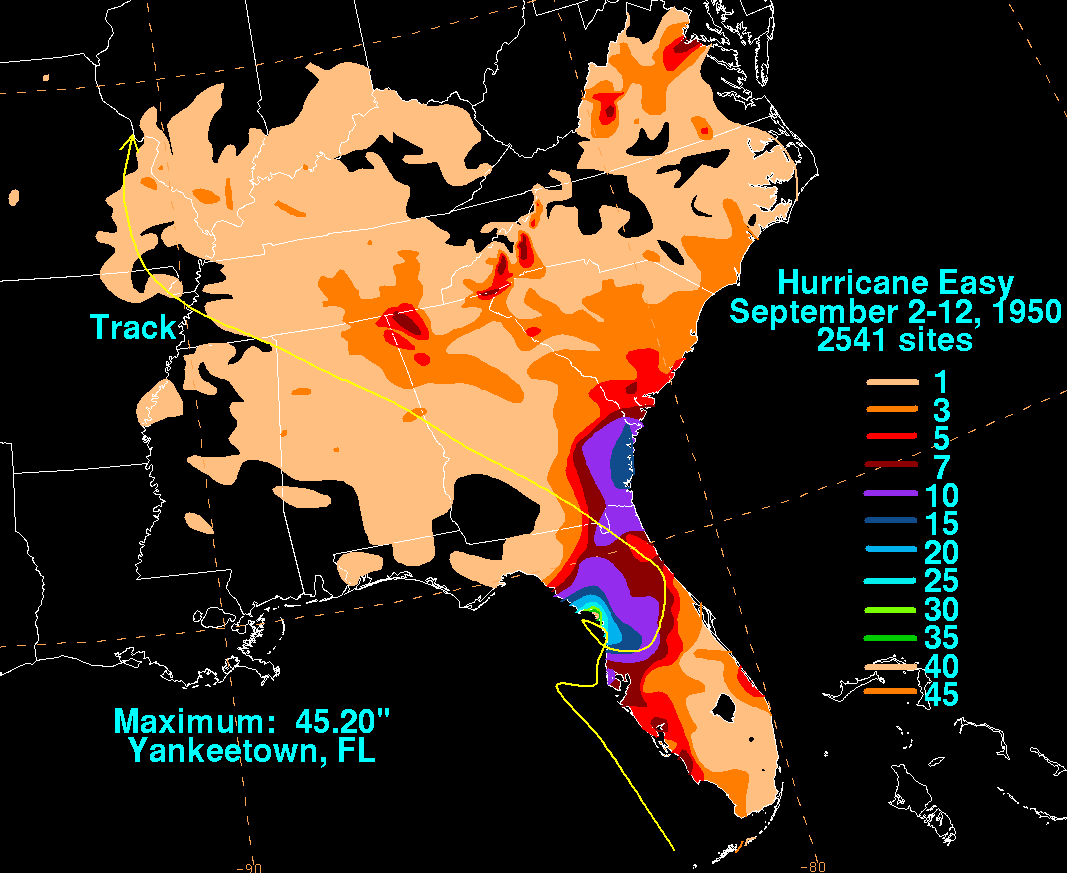
. Heavy rainfall and winds also led to some crop damage. - September 5, 1950- Hurricane EasyHurricane Easy (1950)Hurricane Easy was the fifth tropical storm, hurricane, and major hurricane of the 1950 Atlantic hurricane season. The hurricane developed in the western Caribbean Sea on September 1, and tracked northeastward. After crossing Cuba, the hurricane rapidly strengthened in the eastern Gulf of Mexico to...
moves ashore near Cedar KeyCedar Key, FloridaCedar Key is a city in Levy County, Florida, United States. The population was 790 at the 2000 census. According to the U.S Census estimates of 2005, the city had a population of 958. The Cedar Keys are a cluster of islands close to the mainland. Most of the developed area of the city has been on...
and later near Tampa BayTampa BayTampa Bay is a large natural harbor and estuary along the Gulf of Mexico on the west central coast of Florida, comprising Hillsborough Bay, Old Tampa Bay, Middle Tampa Bay, and Lower Tampa Bay."Tampa Bay" is not the name of any municipality...
as a major hurricane after looping offshore. The hurricane causes locally heavy damage in a sparsely populated area, totaling $3.3 million (1950 USD, $29.5 million 2008 USD). Due to its erratic motion, Easy drops heavy rainfall peaking at 38.7 inches (983 mm) in YankeetownYankeetown, FloridaYankeetown is a town in Levy County, Florida, United States. The population was 629 at the 2000 census. According to the U.S. Census Bureau's 2004 estimates, the town had a population of 672.-History:...
, which in turn causes 2 indirect deaths from electrocution. - October 18, 1950- Hurricane KingHurricane KingHurricane King was the most severe hurricane to strike Florida since the 1926 Miami hurricane. It was the eleventh tropical storm and the last of a record-setting eight major hurricanes in the 1950 Atlantic hurricane season. The cyclone formed in the western Caribbean Sea on October 13, and...
makes landfall on MiamiMiami, FloridaMiami is a city located on the Atlantic coast in southeastern Florida and the county seat of Miami-Dade County, the most populous county in Florida and the eighth-most populous county in the United States with a population of 2,500,625...
as a major hurricane. Its hurricane force winds blows out the windows of many buildings in downtown Miami, resulting in several injuries. Across the state, the storm causes 3 deaths and heavy damage totaling $27.8 million (1950 USD, $249 million 2008 USD), of which over half occurred in the Miami area. - October 21, 1950- The threat of Hurricane Love results in hurricane evacuations along the western coastline, though dry air in the storm leads to very little effects after it hits near the mouth of the Steinhatchee RiverSteinhatchee RiverThe Steinhatchee River is a short river in the Big Bend region of Florida in the U.S.A.. The river rises in the Mallory Swamp just south of Mayo in Lafayette County and flows for out of Lafayette County, forming the boundary between Dixie County and Taylor County to the Gulf of Mexico. It has a...
. - May 18, 1951- The outer rainbandRainbandA rainband is a cloud and precipitation structure associated with an area of rainfall which is significantly elongated. Rainbands can be stratiform or convective, and are generated by differences in temperature. When noted on weather radar imagery, this precipitation elongation is referred to as...
s of Hurricane AbleHurricane Able (1951)Hurricane Able was the strongest recorded hurricane outside of the typical Atlantic hurricane season. The first tropical cyclone in 1951, Able developed from a trough of low pressure on May 15 about 300 miles south of Bermuda...
produce light rainfall and high seas along the eastern coastline. - October 2, 1951- Hurricane How hits Fort MyersFort Myers, FloridaFort Myers is the county seat and commercial center of Lee County, Florida, United States. Its population was 62,298 in the 2010 census, a 29.23 percent increase over the 2000 figure....
, and produces flooding rains and winds of up to 60 miles per hour (96.6 km/h). The storm results in $2 million in damage (1951 USD, $17 million 2008 USD), which is the only reported damage in the United States during the year. - February 3, 1952- An off-season tropical storm unofficially named the Groundhog Day Tropical Storm1952 Groundhog Day Tropical StormThe 1952 Groundhog Day Storm was the only Atlantic tropical cyclone on record in the month of February. First observed in the western Caribbean Sea on February 2, it moved rapidly throughout its duration and struck southwestern Florida within 24 hours of forming. In the state, the winds...
hits near Cape SableCape SableCape Sable, Florida is the southernmost point of the US mainland and mainland Florida. It is located in southwestern Florida, in Monroe County, and is part of the Everglades National Park. The cape is a peninsula issuing from the southeastern part of the Florida mainland, running west and curving...
, producing gusty winds and moderate rainfall. - August 30, 1952- Hurricane AbleHurricane Able (1952)Hurricane Able was the only hurricane to make landfall in the United States in the 1952 season. Forming on August 18 off the west coast of Africa, Able moved generally west- to west-northwestward for much of its duration. It was first observed by the Hurricane Hunters on August 25 to the...
recurves about 130 miles (210 km) east of the state, with the western portion of its circulation dropping 1.69 inches (42.9 mm) of precipitation in JacksonvilleJacksonville, FloridaJacksonville is the largest city in the U.S. state of Florida in terms of both population and land area, and the largest city by area in the contiguous United States. It is the county seat of Duval County, with which the city government consolidated in 1968...
. - June 6, 1953- Tropical Storm Alice dissipates shortly after moving ashore near Panama CityPanama City, Florida-Personal income:The median income for a household in the city was $31,572, and the median income for a family was $40,890. Males had a median income of $30,401 versus $21,431 for females. The per capita income for the city was $17,830...
, producing rainfall which breaks a dry spell in the state. - August 29, 1953- An unnamed tropical storm hits near Fort MyersFort Myers, FloridaFort Myers is the county seat and commercial center of Lee County, Florida, United States. Its population was 62,298 in the 2010 census, a 29.23 percent increase over the 2000 figure....
. While crossing the state it drops moderate precipitation, including 3.85 inches (97.8 mm) in Palm BeachPalm Beach, FloridaThe Town of Palm Beach is an incorporated town in Palm Beach County, Florida, United States. The Intracoastal Waterway separates it from the neighboring cities of West Palm Beach and Lake Worth...
. - September 20, 1953- The seventh storm of the season hits near YankeetownYankeetown, FloridaYankeetown is a town in Levy County, Florida, United States. The population was 629 at the 2000 census. According to the U.S. Census Bureau's 2004 estimates, the town had a population of 672.-History:...
, though its impact is unknown. - September 26, 1953- Hurricane FlorenceHurricane Florence (1953)Hurricane Florence was a minimal Atlantic hurricane that struck the Florida Panhandle in September of the 1953 season. The eighth storm and fifth hurricane of the season, Florence developed in the western Caribbean from a tropical wave near Jamaica on September 23. It produced heavy rainfall...
moves ashore near DestinDestin, FloridaDestin is a city located in Okaloosa County, Florida. It is a principal city of the Fort Walton Beach-Crestview-Destin, Florida Metropolitan Statistical Area.Located on Florida's Emerald Coast, Destin is known for its white beaches and emerald green waters...
, causing rough surf and local flooding. Overall damage is minor, and the hurricane results in 3 injuries but no deaths. - Early October, 1953 – An unnamed tropical storm1953 Atlantic hurricane seasonThe 1953 Atlantic hurricane season was the first time an organized list of female names was used to name Atlantic storms. It officially began on June 15, and lasted until November 15, although activity occurred both before and after the season's limits...
drops light rainfall across the state. - October 9, 1953- Hurricane Hazel strikes Fort MyersFort Myers, FloridaFort Myers is the county seat and commercial center of Lee County, Florida, United States. Its population was 62,298 in the 2010 census, a 29.23 percent increase over the 2000 figure....
, and produces gusty winds and additional rainfall to previously wet conditions. The passage of the storm causes flooding of low-lying areas and some rivers, with the upper region of the St. Johns RiverSt. Johns RiverThe St. Johns River is the longest river in the U.S. state of Florida and its most significant for commercial and recreational use. At long, it winds through or borders twelve counties, three of which are the state's largest. The drop in elevation from the headwaters to the mouth is less than ;...
experiencing record-setting flooding. - August 21, 1955- Tropical Storm Brenda strikes southeastern LouisianaLouisianaLouisiana is a state located in the southern region of the United States of America. Its capital is Baton Rouge and largest city is New Orleans. Louisiana is the only state in the U.S. with political subdivisions termed parishes, which are local governments equivalent to counties...
, with its outer rainbands dropping precipitation along the western Florida PanhandleFlorida PanhandleThe Florida Panhandle, an informal, unofficial term for the northwestern part of Florida, is a strip of land roughly 200 miles long and 50 to 100 miles wide , lying between Alabama on the north and the west, Georgia also on the north, and the Gulf of Mexico to the south. Its eastern boundary is...
. - July 6, 1956- A tropical depression moves ashore near PensacolaPensacola, FloridaPensacola is the westernmost city in the Florida Panhandle and the county seat of Escambia County, Florida, United States of America. As of the 2000 census, the city had a total population of 56,255 and as of 2009, the estimated population was 53,752...
, resulting in light damage and moderate precipitation. - September 24, 1956- Hurricane FlossyHurricane Flossy (1956)Hurricane Flossy originated from a tropical disturbance in the eastern Pacific Ocean and moved across Central America into the Gulf of Mexico as a tropical depression on September 21, which became a tropical storm on September 22 and a hurricane on September 23...
hits near DestinDestin, FloridaDestin is a city located in Okaloosa County, Florida. It is a principal city of the Fort Walton Beach-Crestview-Destin, Florida Metropolitan Statistical Area.Located on Florida's Emerald Coast, Destin is known for its white beaches and emerald green waters...
as a minimal hurricane, resulting in gusty winds and high tides reaching 7.4 feet (2.3 m). The storm causes light damage and 4 indirect deaths in near TallahasseeTallahassee, FloridaTallahassee is the capital of the U.S. state of Florida. It is the county seat and only incorporated municipality in Leon County, and is the 128th largest city in the United States. Tallahassee became the capital of Florida, then the Florida Territory, in 1824. In 2010, the population recorded by...
from an airplane crash during an evacuation. - October 15, 1956- A quasi-tropical storm makes landfall near MiamiMiami, FloridaMiami is a city located on the Atlantic coast in southeastern Florida and the county seat of Miami-Dade County, the most populous county in Florida and the eighth-most populous county in the United States with a population of 2,500,625...
and drops moderate to heavy rainfall. The storm causes $3 million in damage (1956 USD, $24 million 2008 USD) and 2 deaths from drowning. - November, 1956- Rough surf from Hurricane Greta causes about $1.1 million in damage (1956 USD, $8.7 million 2008 USD) along the eastern coastline, primarily near JacksonvilleJacksonville, FloridaJacksonville is the largest city in the U.S. state of Florida in terms of both population and land area, and the largest city by area in the contiguous United States. It is the county seat of Duval County, with which the city government consolidated in 1968...
. - June 8, 1957- The first storm of the season hits near TallahasseeTallahassee, FloridaTallahassee is the capital of the U.S. state of Florida. It is the county seat and only incorporated municipality in Leon County, and is the 128th largest city in the United States. Tallahassee became the capital of Florida, then the Florida Territory, in 1824. In 2010, the population recorded by...
, dropping heavy rainfall of over 19 inches (482.6 mm) in Suwannee CountySuwannee County, FloridaSuwannee County is a county located in the state of Florida. As of 2000, the population was 34,844. The U.S. Census Bureau 2005 estimate for the county was 38,624 . Its county seat is Live Oak, Florida. Suwannee County was a dry county until August, 2011.....
which forces hundreds of families to evacuate. Offshore, rough waves capsize a boat and kill 5, with minimal onshore damage. - September 8, 1957- Tropical Storm Debbie moves ashore along the Florida PanhandleFlorida PanhandleThe Florida Panhandle, an informal, unofficial term for the northwestern part of Florida, is a strip of land roughly 200 miles long and 50 to 100 miles wide , lying between Alabama on the north and the west, Georgia also on the north, and the Gulf of Mexico to the south. Its eastern boundary is...
, causing flooding, rainfall, and 4 indirect deaths. - September 4, 1958- Tropical Storm Ella emerges into the Gulf of MexicoGulf of MexicoThe Gulf of Mexico is a partially landlocked ocean basin largely surrounded by the North American continent and the island of Cuba. It is bounded on the northeast, north and northwest by the Gulf Coast of the United States, on the southwest and south by Mexico, and on the southeast by Cuba. In...
after crossing CubaCubaThe Republic of Cuba is an island nation in the Caribbean. The nation of Cuba consists of the main island of Cuba, the Isla de la Juventud, and several archipelagos. Havana is the largest city in Cuba and the country's capital. Santiago de Cuba is the second largest city...
, with its outer rainbands producing gale force wind gusts in the Florida KeysFlorida KeysThe Florida Keys are a coral archipelago in southeast United States. They begin at the southeastern tip of the Florida peninsula, about south of Miami, and extend in a gentle arc south-southwest and then westward to Key West, the westernmost of the inhabited islands, and on to the uninhabited Dry...
. The winds uproots a few trees, though damage is minor. - June 18, 1959- An unnamed tropical depression1959 Escuminac HurricaneThe Escuminac Hurricane is the name given for a rare June hurricane which struck Canada's Gulf of St. Lawrence on the night of June 19 during the 1959 Atlantic hurricane season, sinking 22 fishing boats from the port of Escuminac, New Brunswick, Canada, and drowning 35.-Meteorological history:A...
hits near Tampa BayTampa BayTampa Bay is a large natural harbor and estuary along the Gulf of Mexico on the west central coast of Florida, comprising Hillsborough Bay, Old Tampa Bay, Middle Tampa Bay, and Lower Tampa Bay."Tampa Bay" is not the name of any municipality...
and spawns at least two tornadoes, one of which causes heavy damage and many injuries in MiamiMiami, FloridaMiami is a city located on the Atlantic coast in southeastern Florida and the county seat of Miami-Dade County, the most populous county in Florida and the eighth-most populous county in the United States with a population of 2,500,625...
. High tides and moderate rainfall caused damage, as well, and monetary damage across the state totals $1.5 million (1959 USD, $11.1 million 2008 USD). - October 8, 1959- Tropical Storm Irene hits near PensacolaPensacola, FloridaPensacola is the westernmost city in the Florida Panhandle and the county seat of Escambia County, Florida, United States of America. As of the 2000 census, the city had a total population of 56,255 and as of 2009, the estimated population was 53,752...
and causes a peak wind gust of 55 miles per hour (88.5 km/h) as well as a storm tideStorm tideA storm tide is a tide with a high flood period caused by a storm. Storm tides can be a severe danger to the coast and the people living along the coast. The water level can rise to more than 5 meters above the normal tide....
reaching 4.4 feet (1.3 m) above normal. Damage is minor. - October 18, 1959- Tropical Storm Judith strikes near Fort MyersFort Myers, FloridaFort Myers is the county seat and commercial center of Lee County, Florida, United States. Its population was 62,298 in the 2010 census, a 29.23 percent increase over the 2000 figure....
, producing light to moderate rainfall peaking at 7.9 inches (200.7 mm) in Miles CityMiles City, FloridaMiles City is an unincorporated community in Collier County, Florida, United States. It is located near the intersection of the Alligator Alley portion of Interstate 75 and State Road 29. The community is part of the Naples–Marco Island Metropolitan Statistical Area...
. Damage from the storm is minor, with no deaths and only one injury attributed to Judith.
1960–1969
- July 29, 1960- Tropical Storm Brenda hits near YankeetownYankeetown, FloridaYankeetown is a town in Levy County, Florida, United States. The population was 629 at the 2000 census. According to the U.S. Census Bureau's 2004 estimates, the town had a population of 672.-History:...
, producing locally heavy rainfall which reaches over 13 inches (330 mm) near TampaTampa, FloridaTampa is a city in the U.S. state of Florida. It serves as the county seat for Hillsborough County. Tampa is located on the west coast of Florida. The population of Tampa in 2010 was 335,709....
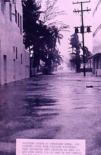
. The rainfall causes flooding and a few indirect traffic deaths, and damage in the state totals $5 million (1960 USD, $36 million 2008 USD). - September 10, 1960- Hurricane DonnaHurricane DonnaHurricane Donna in the 1960 Atlantic hurricane season was a Cape Verde-type hurricane which moved across the Leeward Islands, Puerto Rico, Hispanola, Cuba, The Bahamas, and every state on the East Coast of the United States...
strikes near Cape SableCape SableCape Sable, Florida is the southernmost point of the US mainland and mainland Florida. It is located in southwestern Florida, in Monroe County, and is part of the Everglades National Park. The cape is a peninsula issuing from the southeastern part of the Florida mainland, running west and curving...
after crossing the Florida KeysFlorida KeysThe Florida Keys are a coral archipelago in southeast United States. They begin at the southeastern tip of the Florida peninsula, about south of Miami, and extend in a gentle arc south-southwest and then westward to Key West, the westernmost of the inhabited islands, and on to the uninhabited Dry...
, and after briefly moving emerging into the Gulf of MexicoGulf of MexicoThe Gulf of Mexico is a partially landlocked ocean basin largely surrounded by the North American continent and the island of Cuba. It is bounded on the northeast, north and northwest by the Gulf Coast of the United States, on the southwest and south by Mexico, and on the southeast by Cuba. In...
makes its final landfall near Fort MyersFort Myers, FloridaFort Myers is the county seat and commercial center of Lee County, Florida, United States. Its population was 62,298 in the 2010 census, a 29.23 percent increase over the 2000 figure....
. It leaves a path of destruction across the entire peninsula, including destroying 30% of the state's grapefruit crop and leveling over half of the mangroveMangroveMangroves are various kinds of trees up to medium height and shrubs that grow in saline coastal sediment habitats in the tropics and subtropics – mainly between latitudes N and S...
trees in the EvergladesEvergladesThe Everglades are subtropical wetlands in the southern portion of the U.S. state of Florida, comprising the southern half of a large watershed. The system begins near Orlando with the Kissimmee River, which discharges into the vast but shallow Lake Okeechobee...
. The passage of the hurricane results in 2,156 destroyed homes, 3,903 severely damaged houses, and 281 boats destroyed or left with major damage. Throughout the state, Donna causes over $300 million in damage (1960 USD, $2.19 billion 2008 USD) and 13 direct deaths. - September 15, 1960- Tropical Storm Ethel strikes MississippiMississippiMississippi is a U.S. state located in the Southern United States. Jackson is the state capital and largest city. The name of the state derives from the Mississippi River, which flows along its western boundary, whose name comes from the Ojibwe word misi-ziibi...
after rapidly weakening from a strong hurricane, and causes light winds and rainfall across western Florida. Damage totals about $250,000 (1960 USD, $1.8 million 2008 USD), primarily from crop damage. - September 23, 1960- Tropical Depression Florence strikes near ChokoloskeeChokoloskee, FloridaChokoloskee is a census-designated place in Collier County, Florida, United States. The population was 404 at the 2000 census. It is part of the Naples–Marco Island Metropolitan Statistical Area.-Geography:...
, and after turning westward near Vero BeachVero Beach, FloridaVero Beach is a city in Indian River County, Florida, USA. According to the U.S. Census Bureau's 2006 estimates, the city had a population of 16,939. It is the county seat of Indian River County...
emerges into the Gulf of MexicoGulf of MexicoThe Gulf of Mexico is a partially landlocked ocean basin largely surrounded by the North American continent and the island of Cuba. It is bounded on the northeast, north and northwest by the Gulf Coast of the United States, on the southwest and south by Mexico, and on the southeast by Cuba. In...
before making a final landfall near PensacolaPensacola, FloridaPensacola is the westernmost city in the Florida Panhandle and the county seat of Escambia County, Florida, United States of America. As of the 2000 census, the city had a total population of 56,255 and as of 2009, the estimated population was 53,752...
. The storm drops moderate amounts of rainfall, causing localized but minor amounts of damage. - September 11, 1961- Hurricane CarlaHurricane CarlaHurricane Carla was one of two Category 5 tropical cyclones during the 1961 Atlantic hurricane season. It struck the Texas coast as a Category 4 hurricane, becoming one of the most powerful storms to ever strike the United States. Hurricane Carla was the second most intense storm to ever...
strikes TexasTexasTexas is the second largest U.S. state by both area and population, and the largest state by area in the contiguous United States.The name, based on the Caddo word "Tejas" meaning "friends" or "allies", was applied by the Spanish to the Caddo themselves and to the region of their settlement in...
, with its outer rainbands dropping light amounts of precipitation across Florida. - October 29, 1961 – The interaction between Hurricane HattieHurricane HattieHurricane Hattie was the deadliest tropical cyclone of the 1961 Atlantic hurricane season, as well as the strongest, reaching a peak intensity equivalent to Category 5 hurricane intensity...
and a ridge to its north produced squally winds of around 30 mph (50 km/h) across Florida. - August 26, 1962- A tropical depression which later becomes Hurricane Alma brushes the southeastern portion of the state, dropping 3.6 inches (91 mm) of rain at Fort DrumFort Drum, FloridaFort Drum is a town in Okeechobee County, Florida, United States. It is located on US 441, between Yeehaw Junction and Okeechobee. A service plaza on Florida's Turnpike is named after the town. The Fort Drum Wildlife Management Area was named for its proximity to the town and is known as the...
. - October, 1963- Rough surf from Hurricane FloraHurricane FloraHurricane Flora is among the deadliest Atlantic hurricanes in recorded history, with a death total of over 7,000. The seventh tropical storm and sixth hurricane of the 1963 Atlantic hurricane season, Flora developed from a disturbance in the Intertropical Convergence Zone on September 26 while...
kills one in MiamiMiami, FloridaMiami is a city located on the Atlantic coast in southeastern Florida and the county seat of Miami-Dade County, the most populous county in Florida and the eighth-most populous county in the United States with a population of 2,500,625...
. - October 21, 1963- Hurricane Ginny passes about 50 miles (80 km) east of the state before turning northeastward, producing gusty winds, light rainfall, and minor damage.
- June 6, 1964- A tropical depression hits near YankeetownYankeetown, FloridaYankeetown is a town in Levy County, Florida, United States. The population was 629 at the 2000 census. According to the U.S. Census Bureau's 2004 estimates, the town had a population of 672.-History:...
and exits near JacksonvilleJacksonville, FloridaJacksonville is the largest city in the U.S. state of Florida in terms of both population and land area, and the largest city by area in the contiguous United States. It is the county seat of Duval County, with which the city government consolidated in 1968...
. The depression produces thunderstorm activity and hail storms across the northern portion of the state, causing about $1 million in damage (1964 USD, $7 million 2008 USD).
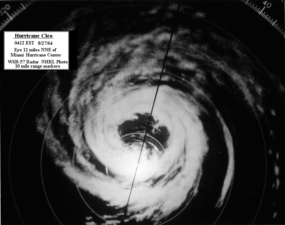
- August 27, 1964- Hurricane CleoHurricane CleoHurricane Cleo was the third named storm, first hurricane, and first major hurricane of the 1964 Atlantic hurricane season. Cleo was one of the longest-lived storms of the season...
strikes near MiamiMiami, FloridaMiami is a city located on the Atlantic coast in southeastern Florida and the county seat of Miami-Dade County, the most populous county in Florida and the eighth-most populous county in the United States with a population of 2,500,625...
with winds of about 105 mph (170 km/h), the first hurricane to hit the area in 14 years. Strong winds from the hurricane down many trees and power lines, with moderate to heavy building and crop damage reported near the coast. Rainfall reaches 6.8 inches (173 mm) in Miami, with storm tideStorm tideA storm tide is a tide with a high flood period caused by a storm. Storm tides can be a severe danger to the coast and the people living along the coast. The water level can rise to more than 5 meters above the normal tide....
s peaking at 5.5 feet (1.7 m) in Pompano BeachPompano Beach, FloridaPompano Beach ) is a city in Broward County, Florida, along the coast of the Atlantic Ocean just to the north of Fort Lauderdale. The nearby Hillsboro Inlet forms part of the Atlantic Intracoastal Waterway. As of the 2010 census, the city's population was 99,845...
. Damage in the state amounts to $125 million (1964 USD, $870 million 2008 USD); no deaths are reported in the state. - September 10, 1964- Hurricane DoraHurricane DoraHurricane Dora was the first tropical cyclone on record to make landfall over the extreme northeast coast of Florida. Dora was also the first storm to produce hurricane force winds to Jacksonville, Florida in the almost 80 years of record keeping. Dora killed five people and left over...
makes landfall as a weakening Category 2 hurricane near JacksonvilleJacksonville Beach, FloridaJacksonville Beach is a city on the Atlantic coast of Duval County, Florida, east of Jacksonville. It is part of the Jacksonville Beaches community, together with Mayport, Atlantic Beach, Neptune Beach, and Ponte Vedra Beach...
, the first hurricane in an extended period of time to strike the area. Dora produces moderate to heavy amounts of precipitation which peaks at 23.73 inches (603 mm) in MayoMayo, FloridaMayo is a town and the only municipality in Lafayette County, Florida, United States. The population was 988 at the 2000 census. As of 2004, the population recorded by the U.S. Census Bureau is 1,009...
, causing flooding damage and killing one from drowning. Wind gusts peak at 125 mph (200 km/h) near Saint Augustine, causing massive utility failures and heavy damage to buildings. Two NavyUnited States NavyThe United States Navy is the naval warfare service branch of the United States Armed Forces and one of the seven uniformed services of the United States. The U.S. Navy is the largest in the world; its battle fleet tonnage is greater than that of the next 13 largest navies combined. The U.S...
personnel die when their evacuating plane crashed upon takeoff. Damage totaled about $220 million (1964 USD, $1.53 billion 2008 USD). - September 20, 1964- Hurricane GladysHurricane Gladys (1964)Hurricane Gladys was the ninth tropical cyclone , seventh named storm, fourth hurricane and fourth major hurricane of the 1964 Atlantic hurricane season. Gladys formed from on September 13, 1964 as a tropical depression and moved westward where it quickly became a Category 4 hurricane...
produces rough surf along the eastern Florida coastline. - October 5, 1964- The extratropicalExtratropical cycloneExtratropical cyclones, sometimes called mid-latitude cyclones or wave cyclones, are a group of cyclones defined as synoptic scale low pressure weather systems that occur in the middle latitudes of the Earth having neither tropical nor polar characteristics, and are connected with fronts and...
remnant of Hurricane HildaHurricane HildaHurricane Hilda was the third hurricane to make landfall in the United States during the 1964 Atlantic hurricane season. Originating near Cuba, the cyclone intensified while moving through the Gulf of Mexico, and became a Category 4 hurricane in the Gulf of Mexico before striking Louisiana in...
enters the Florida PanhandleFlorida PanhandleThe Florida Panhandle, an informal, unofficial term for the northwestern part of Florida, is a strip of land roughly 200 miles long and 50 to 100 miles wide , lying between Alabama on the north and the west, Georgia also on the north, and the Gulf of Mexico to the south. Its eastern boundary is...
, dropping moderately heavy rainfall and producing high tides. One person drowns while surfing near PensacolaPensacola, FloridaPensacola is the westernmost city in the Florida Panhandle and the county seat of Escambia County, Florida, United States of America. As of the 2000 census, the city had a total population of 56,255 and as of 2009, the estimated population was 53,752...
. - October 14, 1964- Hurricane Isbell makes landfall near EvergladesEverglades, FloridaEverglades is a city in Collier County, Florida, United States. The population was 479 at the 2000 census. As of 2004, the population recorded by the U.S. Census Bureau is 513...
and drops moderate amounts of precipitation peaking at 9.46 inches (240 mm) in West Palm BeachWest Palm Beach, FloridaWest Palm Beach, is a city located on the Atlantic coast in southeastern Florida and is the most populous city in and county seat of Palm Beach County, the third most populous county in Florida with a 2010 population of 1,320,134. The city is also the oldest incorporated municipality in South Florida...
. The hurricane spawns at least 11 tornadoes and injured at least 50, mostly minor. Throughout the state, the hurricane kills three, of which one indirectly, and causes over $5 million (1964 USD, $35 million 2008 USD) in crop damage. - June 15, 1965- An unnamed tropical storm hits near Panama CityPanama City, Florida-Personal income:The median income for a household in the city was $31,572, and the median income for a family was $40,890. Males had a median income of $30,401 versus $21,431 for females. The per capita income for the city was $17,830...
, producing high tides and moderate rainfall peaking at 5.99 inches (152 mm) in TallahasseeTallahassee, FloridaTallahassee is the capital of the U.S. state of Florida. It is the county seat and only incorporated municipality in Leon County, and is the 128th largest city in the United States. Tallahassee became the capital of Florida, then the Florida Territory, in 1824. In 2010, the population recorded by...
. Damage from the storm is minor, and no deaths or injuries are reported.

- September 8, 1965- Hurricane BetsyHurricane BetsyHurricane Betsy was a Category 4 hurricane of the 1965 Atlantic hurricane season which caused enormous damage in the Bahamas, Florida, and Louisiana. Betsy made its most intense landfall near the mouth of the Mississippi River, causing significant flooding of the waters of Lake Pontchartrain into...
passes through the Florida KeysFlorida KeysThe Florida Keys are a coral archipelago in southeast United States. They begin at the southeastern tip of the Florida peninsula, about south of Miami, and extend in a gentle arc south-southwest and then westward to Key West, the westernmost of the inhabited islands, and on to the uninhabited Dry...
as a major hurricane, producing moderate rainfall reaching 11.8 inches (300 mm) at Plantation KeyPlantation Key, FloridaPlantation Key, Florida is a former census-designated place on Plantation Key in the Florida Keys, in Monroe County, Florida, United States. It was reported to have a population of 4,405 in 1990. It became part of the Village of Islamorada when the latter incorporated in 1997.-External links:*...
and wind gusts reaching an estimated peak of 160 mph (255 km/h) in North Key LargoNorth Key Largo, FloridaNorth Key Largo is a census-designated place in Monroe County, Florida, United States. The population was 1,049 at the 2000 census.-Geography:North Key Largo is located at ....
. The rainfall provided relief to a water shortage in the EvergladesEvergladesThe Everglades are subtropical wetlands in the southern portion of the U.S. state of Florida, comprising the southern half of a large watershed. The system begins near Orlando with the Kissimmee River, which discharges into the vast but shallow Lake Okeechobee...
, while strong waves and high tides causes considerable flooding in coastal and low-lying areas in the southeastern portion of the state. The passage of Betsy results in 4 deaths and $139.3 million in damage (1965 USD, $953 million 2008 USD) in the state. - September 30, 1965- Tropical Storm Debbie dissipates off of the coast of MississippiMississippiMississippi is a U.S. state located in the Southern United States. Jackson is the state capital and largest city. The name of the state derives from the Mississippi River, which flows along its western boundary, whose name comes from the Ojibwe word misi-ziibi...
and drops 3—5 inches (75–125 mm) of precipitation across the northern region of the state. - June 9, 1966- Hurricane AlmaHurricane Alma (1966)Hurricane Alma was a rare June major hurricane in the 1966 Atlantic hurricane season. It was the earliest continental U.S. hurricane strike within any season since 1908...
makes landfall near ApalachicolaApalachicola, FloridaApalachicola is a city in Franklin County, Florida, on US 98 about southwest of Tallahassee. The population was 2,334 at the 2000 census. The 2005 census estimated the city's population at 2,340...
as a Category TwoSaffir-Simpson Hurricane ScaleThe Saffir–Simpson Hurricane Scale , or the Saffir–Simpson Hurricane Wind Scale , classifies hurricanes — Western Hemisphere tropical cyclones that exceed the intensities of tropical depressions and tropical storms — into five categories distinguished by the intensities of their sustained winds...
hurricane after paralleling the western coastline as a major hurricane. Rainfall peaked at 7.7 inches (196 mm) in MiamiMiami, FloridaMiami is a city located on the Atlantic coast in southeastern Florida and the county seat of Miami-Dade County, the most populous county in Florida and the eighth-most populous county in the United States with a population of 2,500,625...
, while tides reached 10 feet (3 m) above normal. Alma causes $10 million in damage (1966 USD, $66 million 2008 USD), 2 direct deaths from drowning, and 4 indirect deaths. - June 30, 1966- A tropical depression forms in the western Caribbean Sea and moves on a track similar to Alma. The center passed near Key LargoKey Largo, FloridaKey Largo is a census-designated place in Monroe County, Florida, United States, located on the island of Key Largo in the upper Florida Keys. The population was 11,886 at the 2000 census. The name comes from the Spanish Cayo Largo, or "long key"...
, producing two tornadoes, one of which destroyed two aircraft at Palm Beach International AirportPalm Beach International AirportPalm Beach International Airport is a public airport located 3 nautical miles west of Palm Beach, Florida, in West Palm Beach, Florida, and serves Palm Beach County. The airport is operated and maintained by Palm Beach County Department of Airports. Road access to the airport is available...
, as well as moderate to heavy rainfall totaling nearly 10 inches (250 mm) at Everglades CityEverglades, FloridaEverglades is a city in Collier County, Florida, United States. The population was 479 at the 2000 census. As of 2004, the population recorded by the U.S. Census Bureau is 513...
and JacksonvilleJacksonville, FloridaJacksonville is the largest city in the U.S. state of Florida in terms of both population and land area, and the largest city by area in the contiguous United States. It is the county seat of Duval County, with which the city government consolidated in 1968...
. The combination of Alma and this tropical depression brought 21.37 inches/542.8 mm to Miami, FloridaMiami, FloridaMiami is a city located on the Atlantic coast in southeastern Florida and the county seat of Miami-Dade County, the most populous county in Florida and the eighth-most populous county in the United States with a population of 2,500,625...
, which established a new June rainfall record for that location. - July 24, 1966- The precursor tropical low to a tropical depression crosses the northern portion of the state; its effects are minimal.
- October 4, 1966- Hurricane InezHurricane InezHurricane Inez was a deadly, destructive, powerful and very long-lived Cape Verde-type hurricane that carved an erratic path through the Lesser Antilles, Hispaniola, Cuba, the Bahamas, Florida, and Mexico in 1966...
passes through the Florida KeysFlorida KeysThe Florida Keys are a coral archipelago in southeast United States. They begin at the southeastern tip of the Florida peninsula, about south of Miami, and extend in a gentle arc south-southwest and then westward to Key West, the westernmost of the inhabited islands, and on to the uninhabited Dry...
, resulting in 3 deaths and $5 million in damage (1966 USD, $33 million 2008 USD). Rainfall in the state peaks at 4.8 inches (122 mm) at KendallKendall, FloridaKendall is a suburban neighborhood of metropolitan Miami, Florida, United States. As of the 2000 census, the area had a total population of 75,226....
, while offshore the hurricane results in 45 casualties in the Florida Straits. - June 4, 1968- Tropical Storm AbbyHurricane Abby (1968)Hurricane Abby was the first named storm and first hurricane of the 1968 Atlantic hurricane season. Abby was one of four tropical cyclones to strike Florida during the 1968 season and one of three tropical cyclones to form in June 1968...
moves ashore near Punta GordaPunta Gorda, FloridaPunta Gorda is a city in Charlotte County, Florida, United States. According to the U.S. Census Bureau estimates of 2007, the city had a population of 16,762. It is the county seat of Charlotte County and the only incorporated municipality in the county...
, spawning 3 small tornadoes and producing up to 14.2 inches (361 mm) of precipitation at CocoaCocoa, FloridaCocoa is a city in Brevard County, Florida, United States. The population was 16,412 at the 2000 census. As of 2008, the estimated population according to the U.S. Census Bureau was 16,478. It is part of the Palm Bay–Melbourne–Titusville Metropolitan Statistical Area.-History:Cocoa was...
. The rainfall is beneficial and ends a severe, persistent drought in the state. The storm causes six indirect deaths in the state. - June 18, 1968- The precursor tropical depression to Hurricane Brenda passes across the eastern portion of the state, dropping moderate precipitation peaking at 8.61 inches (219 mm) in HomesteadHomestead, FloridaHomestead is a city in Miami-Dade County, Florida, United States nestled between Biscayne National Park to the east and Everglades National Park to the west. Homestead is primarily a Miami suburb and a major agricultural area....
. No damage is reported. - July 5, 1968- A tropical depression strikes the Florida PanhandleFlorida PanhandleThe Florida Panhandle, an informal, unofficial term for the northwestern part of Florida, is a strip of land roughly 200 miles long and 50 to 100 miles wide , lying between Alabama on the north and the west, Georgia also on the north, and the Gulf of Mexico to the south. Its eastern boundary is...
and quickly dissipates, though its impact is unknown. - August 10, 1968- The precursor tropical depression to Hurricane Dolly moves through the eastern portion of the state, producing gusty winds though no known damage.
- August 28, 1968- A tropical depression stalls along the western coastline near TampaTampa, FloridaTampa is a city in the U.S. state of Florida. It serves as the county seat for Hillsborough County. Tampa is located on the west coast of Florida. The population of Tampa in 2010 was 335,709....
before turning to the northeast and crossing the state. It drops heavy rainfall, including 15 inches (381 mm) in JacksonvilleJacksonville, FloridaJacksonville is the largest city in the U.S. state of Florida in terms of both population and land area, and the largest city by area in the contiguous United States. It is the county seat of Duval County, with which the city government consolidated in 1968...
, resulting in extensive localized flooding. The depression also spawns a tornado near Daytona BeachDaytona Beach, FloridaDaytona Beach is a city in Volusia County, Florida, USA. According to 2008 U.S. Census Bureau estimates, the city has a population of 64,211. Daytona Beach is a principal city of the Deltona – Daytona Beach – Ormond Beach, Florida Metropolitan Statistical Area, which the census bureau estimated had...
which destroys a motel and several houses.
- September 26, 1968- A tropical depression crosses the southern portion of the state, though its impact is unknown.
- October 19, 1968- Hurricane GladysHurricane Gladys (1968)Hurricane Gladys was the most destructive hurricane in the 1968 Atlantic hurricane season, causing over $100 million in damage and ten deaths. The last storm of the season, it caused heavy rainfall along its path through the Western Caribbean Sea, Florida, and up through Atlantic Canada...
makes landfall just north of Tampa Bay, producing moderate rainfall and two tornadoes while crossing the state. Damage totals $6.7 million (1968 USD, $42 million 2008 USD), primarily due to structural damage. - June 9, 1969- A tropical depression dissipates shortly after passing through the Florida KeysFlorida KeysThe Florida Keys are a coral archipelago in southeast United States. They begin at the southeastern tip of the Florida peninsula, about south of Miami, and extend in a gentle arc south-southwest and then westward to Key West, the westernmost of the inhabited islands, and on to the uninhabited Dry...
. Its effects are unknown. - August 18, 1969- Hurricane CamilleHurricane CamilleHurricane Camille was the third and strongest tropical cyclone and second hurricane during the 1969 Atlantic hurricane season. The second of three catastrophic Category 5 hurricanes to make landfall in the United States during the 20th century , which it did near the mouth of the Mississippi River...
strikes southern MississippiMississippiMississippi is a U.S. state located in the Southern United States. Jackson is the state capital and largest city. The name of the state derives from the Mississippi River, which flows along its western boundary, whose name comes from the Ojibwe word misi-ziibi...
as a Category 5 hurricane, with its large wind field producing a 71 mph (114 km/h) wind gust and 3.55 inches (90 mm) of rain in PensacolaPensacola, FloridaPensacola is the westernmost city in the Florida Panhandle and the county seat of Escambia County, Florida, United States of America. As of the 2000 census, the city had a total population of 56,255 and as of 2009, the estimated population was 53,752...
. The hurricane causes minor crop damage to pecan trees and corn stalks. - August 29, 1969- A tropical depression makes landfall on the east-central portion of the state, though its impact is unknown.
- September 7, 1969- The precursor tropical depression to Hurricane GerdaHurricane Gerda (1969)Hurricane Gerda was a North Atlantic tropical cyclone that formed during the 1969 Atlantic hurricane season. It was the seventh named storm, fifth hurricane and third major hurricane of the 1969 season. Gerda formed on September 6 and crossed Florida as a tropical depression...
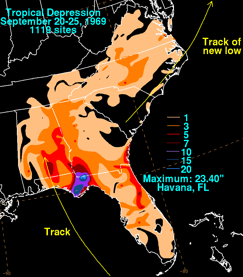
passes over the southeastern portion of the state before turning to the northeast. Its rainfall impact was minimal, as less than three inches (76 mm) of rain fell across the Sunshine State. - September 21, 1969- A tropical depression moves ashore along the western Florida PanhandleFlorida PanhandleThe Florida Panhandle, an informal, unofficial term for the northwestern part of Florida, is a strip of land roughly 200 miles long and 50 to 100 miles wide , lying between Alabama on the north and the west, Georgia also on the north, and the Gulf of Mexico to the south. Its eastern boundary is...
, before stalling. It becomes the wettest known tropical cyclone for the eastern Florida panhandle, when 23.40 inches (594 mm) falls at HavanaHavana, FloridaHavana is a town in Gadsden County, Florida, United States and suburb of Tallahassee. The population was 1,713 at the 2000 census. As of 2004, the population recorded by the U.S. Census Bureau is 1,703...
. - October 1, 1969- Subtropical Depression One hits the western Florida PanhandleFlorida PanhandleThe Florida Panhandle, an informal, unofficial term for the northwestern part of Florida, is a strip of land roughly 200 miles long and 50 to 100 miles wide , lying between Alabama on the north and the west, Georgia also on the north, and the Gulf of Mexico to the south. Its eastern boundary is...
. It effects, if any, are unknown. - October 2, 1969- Tropical Storm Jenny makes landfall near Fort MyersFort Myers, FloridaFort Myers is the county seat and commercial center of Lee County, Florida, United States. Its population was 62,298 in the 2010 census, a 29.23 percent increase over the 2000 figure....
, crosses the state, and approaches the Atlantic OceanAtlantic OceanThe Atlantic Ocean is the second-largest of the world's oceanic divisions. With a total area of about , it covers approximately 20% of the Earth's surface and about 26% of its water surface area...
near Cape CanaveralCape CanaveralCape Canaveral, from the Spanish Cabo Cañaveral, is a headland in Brevard County, Florida, United States, near the center of the state's Atlantic coast. Known as Cape Kennedy from 1963 to 1973, it lies east of Merritt Island, separated from it by the Banana River.It is part of a region known as the...
before turning to the west-southwest and exiting into the Gulf of MexicoGulf of MexicoThe Gulf of Mexico is a partially landlocked ocean basin largely surrounded by the North American continent and the island of Cuba. It is bounded on the northeast, north and northwest by the Gulf Coast of the United States, on the southwest and south by Mexico, and on the southeast by Cuba. In...
near TampaTampa, FloridaTampa is a city in the U.S. state of Florida. It serves as the county seat for Hillsborough County. Tampa is located on the west coast of Florida. The population of Tampa in 2010 was 335,709....
. The storm produces heavy rainfall of 5—8 inches (127–203 mm) across the central region of the state. - October 21, 1969- Hurricane Laurie attains a peak strength of 105 mph (170 km/h) while moving eastward in the Gulf of MexicoGulf of MexicoThe Gulf of Mexico is a partially landlocked ocean basin largely surrounded by the North American continent and the island of Cuba. It is bounded on the northeast, north and northwest by the Gulf Coast of the United States, on the southwest and south by Mexico, and on the southeast by Cuba. In...
. Its threat prompts officials to issue a gale warning from the Florida KeysFlorida KeysThe Florida Keys are a coral archipelago in southeast United States. They begin at the southeastern tip of the Florida peninsula, about south of Miami, and extend in a gentle arc south-southwest and then westward to Key West, the westernmost of the inhabited islands, and on to the uninhabited Dry...
to Fort MyersFort Myers, FloridaFort Myers is the county seat and commercial center of Lee County, Florida, United States. Its population was 62,298 in the 2010 census, a 29.23 percent increase over the 2000 figure....
, though Laurie turns to the southwest and does not impact the state.
1970
.jpg)
- May 25, 1970- Tropical Depression AlmaHurricane Alma (1970)Hurricane Alma was one of only four Atlantic tropical cyclones to reach hurricane status in May. It developed on May 17 north of Panama, and rapidly intensified on May 20 to peak winds of , near Jamaica and the Cayman Islands. It stalled south of Cuba and deteriorated due to wind shear, and by...
makes landfall near YankeetownYankeetown, FloridaYankeetown is a town in Levy County, Florida, United States. The population was 629 at the 2000 census. According to the U.S. Census Bureau's 2004 estimates, the town had a population of 672.-History:...
, producing moderate rainfall of 5—10 inches (127–254 mm) which ends a persistent drought in the southern portion of the state. - July 22, 1970- Tropical Storm BeckyTropical Storm Becky (1970)Tropical Storm Becky was the second tropical cyclone and named storm of the 1970 Atlantic hurricane season. Becky formed from a tropical depression that was designated on July 19. The next day it organized over the Yucatan Channel and became Tropical Storm Becky...
hits ApachicolaApalachicola, FloridaApalachicola is a city in Franklin County, Florida, on US 98 about southwest of Tallahassee. The population was 2,334 at the 2000 census. The 2005 census estimated the city's population at 2,340...
, producing moderate rainfall peaking at over 8 inches (203 mm) in TallahasseeTallahassee, FloridaTallahassee is the capital of the U.S. state of Florida. It is the county seat and only incorporated municipality in Leon County, and is the 128th largest city in the United States. Tallahassee became the capital of Florida, then the Florida Territory, in 1824. In 2010, the population recorded by...
which floods 104 houses and injures two. The storm also spawns a tornado which destroys a house and severely damages three others in PanaceaPanacea, FloridaPanacea is a small unincorporated community in Wakulla County, Florida, United States of America. It is in the Tallahassee metro area. Its elevation is seven feet above sea level....
. - August 6, 1970- A tropical depression moves ashore near Cape CanaveralCape CanaveralCape Canaveral, from the Spanish Cabo Cañaveral, is a headland in Brevard County, Florida, United States, near the center of the state's Atlantic coast. Known as Cape Kennedy from 1963 to 1973, it lies east of Merritt Island, separated from it by the Banana River.It is part of a region known as the...
, though its effects, if any, are unknown. - September 13, 1970- The precursor tropical depression to Tropical Storm FeliceTropical Storm Felice (1970)Tropical Storm Felice was a mid-September tropical storm that formed during the 1970 Atlantic hurricane season. The seventh tropical cyclone of the 1970 season, Felice formed over the Bahamas as a tropical depression on September 12 and crossed southern Florida where it reached tropical storm...
passes through the Florida KeysFlorida KeysThe Florida Keys are a coral archipelago in southeast United States. They begin at the southeastern tip of the Florida peninsula, about south of Miami, and extend in a gentle arc south-southwest and then westward to Key West, the westernmost of the inhabited islands, and on to the uninhabited Dry...
, dropping beneficial rainfall to the southern portion of the state. - September 27, 1970- Tropical Storm Greta passes through the Florida KeysFlorida KeysThe Florida Keys are a coral archipelago in southeast United States. They begin at the southeastern tip of the Florida peninsula, about south of Miami, and extend in a gentle arc south-southwest and then westward to Key West, the westernmost of the inhabited islands, and on to the uninhabited Dry...
as a weakening tropical cyclone, producing tropical storm force wind gusts but no reported damage.
1971
- August 10, 1971- A tropical depression which later becomes Hurricane Beth forms near MiamiMiami, FloridaMiami is a city located on the Atlantic coast in southeastern Florida and the county seat of Miami-Dade County, the most populous county in Florida and the eighth-most populous county in the United States with a population of 2,500,625...
and subsequently tracks northeastward. Its effects in the state, if any, are unknown. - August 13, 1971- A tropical depression strikes Fort MyersFort Myers, FloridaFort Myers is the county seat and commercial center of Lee County, Florida, United States. Its population was 62,298 in the 2010 census, a 29.23 percent increase over the 2000 figure....
, turns to the northwest into the Gulf of MexicoGulf of MexicoThe Gulf of Mexico is a partially landlocked ocean basin largely surrounded by the North American continent and the island of Cuba. It is bounded on the northeast, north and northwest by the Gulf Coast of the United States, on the southwest and south by Mexico, and on the southeast by Cuba. In...
, intensifies as it turned to the northeast, and moves ashore near SteinhatcheeSteinhatchee, FloridaSteinhatchee is a Gulf coastal community in the southern part of Taylor County, Florida. Steinhatchee is located at , 33 miles By Hwy 38.09 miles south of the county seat of Perry. Just aross the Steinhatchee River is Jena, which is in Dixie County. Steinhatchee is 19.27 Hwy miles North of The...
. The depression produces hurricane force wind gusts at Cedar KeyCedar Key, FloridaCedar Key is a city in Levy County, Florida, United States. The population was 790 at the 2000 census. According to the U.S Census estimates of 2005, the city had a population of 958. The Cedar Keys are a cluster of islands close to the mainland. Most of the developed area of the city has been on...
and drops rainfall of over 8 inches (203 mm), resulting in some coastal flooding. - August 29, 1971- A tropical depression moves across the southern portion of the state, though its effects are unknown.
- September 1, 1971- The mid-level precursor disturbance to Hurricane FernHurricane Fern (1971)Hurricane Fern was the sixth named storm and fourth hurricane of the 1971 Atlantic hurricane season. It formed from a tropical wave which interacted with a large trough of low pressure to form Fern, as well as Hurricane Ginger, Tropical Storm Heidi, and a system designated Tropical Depression...
moves across the central portion of the state, dropping moderate precipitation which reaches over 5 inches (127 mm) near MiamiMiami, FloridaMiami is a city located on the Atlantic coast in southeastern Florida and the county seat of Miami-Dade County, the most populous county in Florida and the eighth-most populous county in the United States with a population of 2,500,625...
. - September 16, 1971- Hurricane Edith hits southern LouisianaLouisianaLouisiana is a state located in the southern region of the United States of America. Its capital is Baton Rouge and largest city is New Orleans. Louisiana is the only state in the U.S. with political subdivisions termed parishes, which are local governments equivalent to counties...
, producing light rainfall and a tornado near PensacolaPensacola, FloridaPensacola is the westernmost city in the Florida Panhandle and the county seat of Escambia County, Florida, United States of America. As of the 2000 census, the city had a total population of 56,255 and as of 2009, the estimated population was 53,752...
. - October 13, 1971- A tropical depression moves ashore near ApalachicolaApalachicola, FloridaApalachicola is a city in Franklin County, Florida, on US 98 about southwest of Tallahassee. The population was 2,334 at the 2000 census. The 2005 census estimated the city's population at 2,340...
, though its effects are unknown.
1972
- May 28, 1972- Subtropical Storm AlphaSubtropical Storm Alpha (1972)Subtropical Storm Alpha was a rare off-season subtropical cyclone that hit Georgia in May 1972. It developed from a previously non-tropical cyclone in the western Atlantic Ocean, and initially it moved northeastward off of the Carolinas. The storm turned southwestward due to a building ridge, and...
makes landfall near Brunswick, GeorgiaBrunswick, GeorgiaBrunswick is the major urban and economic center in southeastern Georgia in the United States. The municipality is located on a harbor near the Atlantic Ocean, approximately 30 miles north of Florida and 70 miles south of South Carolina. Brunswick is bordered on the east by the Atlantic...
and turns southwestward across northern Florida, dropping light rainfall across its path but causing no damage.
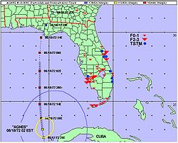
- June 19, 1972- Hurricane AgnesHurricane AgnesHurricane Agnes was the first tropical storm and first hurricane of the 1972 Atlantic hurricane season. A rare June hurricane, it made landfall on the Florida Panhandle before moving northeastward and ravaging the Mid-Atlantic region as a tropical storm...
strikes Panama CityPanama City, Florida-Personal income:The median income for a household in the city was $31,572, and the median income for a family was $40,890. Males had a median income of $30,401 versus $21,431 for females. The per capita income for the city was $17,830...
with minimal hurricane force winds and a storm surge peaking at 7 feet (2.1 m) in Cedar KeyCedar Key, FloridaCedar Key is a city in Levy County, Florida, United States. The population was 790 at the 2000 census. According to the U.S Census estimates of 2005, the city had a population of 958. The Cedar Keys are a cluster of islands close to the mainland. Most of the developed area of the city has been on...
. Agnes produces moderate rainfall throughout the state, amounting to a maximum of 8.97 inches (228 mm) in NaplesNaples, FloridaNaples is a city in Collier County, Florida, United States. As of July 1, 2007, the U.S. Census Bureau estimated the city's population at 21,653. Naples is a principal city of the Naples–Marco Island Metropolitan Statistical Area, which had an estimated total population of 315,839 on July 1, 2007...
. The hurricane spawns 28 tornadoes in the state which destroy 15 houses and 217 trailers. Throughout the state, Agnes causes $8.2 million in damage (1972 USD, $42 million 2008 USD) and nine deaths, seven of which from the tornadoes. - September 5, 1972- The tropical depression that later becomes Hurricane Storm Dawn briefly passes over southeastern Florida before turning northeastward.
1973
- June 7, 1973- A tropical depression develops over the southeastern portion of the state, and briefly enters the Gulf of MexicoGulf of MexicoThe Gulf of Mexico is a partially landlocked ocean basin largely surrounded by the North American continent and the island of Cuba. It is bounded on the northeast, north and northwest by the Gulf Coast of the United States, on the southwest and south by Mexico, and on the southeast by Cuba. In...
before hitting St. Marks. Its effects are unknown. - June 23, 1973- An area of disturbed weather forms into a tropical depression over the northern portion of the state and subsequently tracks to the northeast.
- September 3, 1973- A tropical depression intensifies into Tropical Storm DeliaTropical Storm Delia (1973)Tropical Storm Delia was the first tropical cyclone on record to make landfall in the same city twice. Forming out of a tropical wave on September 1, Delia gradually strengthened into a tropical storm as it moved north by September 3. After reaching this strength, the storm turned more...
over the open Gulf of MexicoGulf of MexicoThe Gulf of Mexico is a partially landlocked ocean basin largely surrounded by the North American continent and the island of Cuba. It is bounded on the northeast, north and northwest by the Gulf Coast of the United States, on the southwest and south by Mexico, and on the southeast by Cuba. In...
, producing light rain across Florida before striking TexasTexasTexas is the second largest U.S. state by both area and population, and the largest state by area in the contiguous United States.The name, based on the Caddo word "Tejas" meaning "friends" or "allies", was applied by the Spanish to the Caddo themselves and to the region of their settlement in...
. - September 25, 1973- JacksonvilleJacksonville, FloridaJacksonville is the largest city in the U.S. state of Florida in terms of both population and land area, and the largest city by area in the contiguous United States. It is the county seat of Duval County, with which the city government consolidated in 1968...
is struck by a tropical depression, though its effects, if any, are unknown.
1974
- June 25, 1974- The combination of Subtropical Storm One, which struck TampaTampa, FloridaTampa is a city in the U.S. state of Florida. It serves as the county seat for Hillsborough County. Tampa is located on the west coast of Florida. The population of Tampa in 2010 was 335,709....
, and a tropical depression to its southwest, produce slightly above normal tides and heavy rainfall reaching 20 inches (508 mm) near Tampa Bay. The passage of these systems cause three fatalities from drowning and $10 million in damage (1974 USD, $44 million 2008 USD) from tidal and rainfall flooding. - September 8, 1974- Hurricane CarmenHurricane CarmenHurricane Carmen was the most intense tropical cyclone of the 1974 Atlantic hurricane season. A destructive and widespread storm, Carmen originated as a tropical disturbance that emerged from Africa toward the end of August. The wave traveled westward, spawning a tropical depression east of the...
makes landfall on southern LouisianaLouisianaLouisiana is a state located in the southern region of the United States of America. Its capital is Baton Rouge and largest city is New Orleans. Louisiana is the only state in the U.S. with political subdivisions termed parishes, which are local governments equivalent to counties...
, with its outer rainbandRainbandA rainband is a cloud and precipitation structure associated with an area of rainfall which is significantly elongated. Rainbands can be stratiform or convective, and are generated by differences in temperature. When noted on weather radar imagery, this precipitation elongation is referred to as...
s producing precipitation across the state that reaches over 10 inches (254 mm) in the extreme northwestern portion of the state. - September 27, 1974- A tropical depression dissipates shortly after moving ashore near Cedar KeyCedar Key, FloridaCedar Key is a city in Levy County, Florida, United States. The population was 790 at the 2000 census. According to the U.S Census estimates of 2005, the city had a population of 958. The Cedar Keys are a cluster of islands close to the mainland. Most of the developed area of the city has been on...
and causes no known effects. - October 7, 1974- Subtropical Storm Four passes just offshore the eastern coastline and produces some beach erosion and localized flooding from rainfall peaking at 14 inches (356 mm) in Boca RatonBoca Raton, FloridaBoca Raton is a city in Palm Beach County, Florida, USA, incorporated in May 1925. In the 2000 census, the city had a total population of 74,764; the 2006 population recorded by the U.S. Census Bureau was 86,396. However, the majority of the people under the postal address of Boca Raton, about...
.
Monthly statistics
| Month | Number of recorded storms affecting Florida |
|---|---|
| February | 1 |
| March | 0 |
| April | 0 |
| May | 3 |
| June | 14 |
| July | 5 |
| August | 14 |
| September | 26 |
| October | 20 |
| November | 1 |
Deadly storms
The following is a list of hurricanes with known deaths in the state.| Name | Year | Number of deaths |
|---|---|---|
| Inez Hurricane Inez Hurricane Inez was a deadly, destructive, powerful and very long-lived Cape Verde-type hurricane that carved an erratic path through the Lesser Antilles, Hispaniola, Cuba, the Bahamas, Florida, and Mexico in 1966... |
1966 | 48 (45 offshore Straits of Florida The Straits of Florida, Florida Straits, or Florida Strait is a strait located south-southeast of the North American mainland, generally accepted to be between the Gulf of Mexico and the Atlantic Ocean, and between the Florida Keys and Cuba. The strait carries the Florida Current, the beginning of... ) |
| Donna Hurricane Donna Hurricane Donna in the 1960 Atlantic hurricane season was a Cape Verde-type hurricane which moved across the Leeward Islands, Puerto Rico, Hispanola, Cuba, The Bahamas, and every state on the East Coast of the United States... |
1960 | 13 |
| Agnes Hurricane Agnes Hurricane Agnes was the first tropical storm and first hurricane of the 1972 Atlantic hurricane season. A rare June hurricane, it made landfall on the Florida Panhandle before moving northeastward and ravaging the Mid-Atlantic region as a tropical storm... |
1972 | 9 |
| Unnamed | 1957 | 5 |
| Betsy Hurricane Betsy Hurricane Betsy was a Category 4 hurricane of the 1965 Atlantic hurricane season which caused enormous damage in the Bahamas, Florida, and Louisiana. Betsy made its most intense landfall near the mouth of the Mississippi River, causing significant flooding of the waters of Lake Pontchartrain into... |
1965 | 4 |
| King Hurricane King Hurricane King was the most severe hurricane to strike Florida since the 1926 Miami hurricane. It was the eleventh tropical storm and the last of a record-setting eight major hurricanes in the 1950 Atlantic hurricane season. The cyclone formed in the western Caribbean Sea on October 13, and... |
1950 | 3 |
| Unnamed | 1974 | 3 |
| Alma Hurricane Alma (1966) Hurricane Alma was a rare June major hurricane in the 1966 Atlantic hurricane season. It was the earliest continental U.S. hurricane strike within any season since 1908... |
1966 | 2 (4 indirect) |
| Isbell | 1964 | 2 (1 indirect) |
| Unnamed | 1956 | 2 |
| Dora Hurricane Dora Hurricane Dora was the first tropical cyclone on record to make landfall over the extreme northeast coast of Florida. Dora was also the first storm to produce hurricane force winds to Jacksonville, Florida in the almost 80 years of record keeping. Dora killed five people and left over... |
1964 | 1 (2 indirect) |
| Flora Hurricane Flora Hurricane Flora is among the deadliest Atlantic hurricanes in recorded history, with a death total of over 7,000. The seventh tropical storm and sixth hurricane of the 1963 Atlantic hurricane season, Flora developed from a disturbance in the Intertropical Convergence Zone on September 26 while... |
1963 | 1 |
| Hilda Hurricane Hilda Hurricane Hilda was the third hurricane to make landfall in the United States during the 1964 Atlantic hurricane season. Originating near Cuba, the cyclone intensified while moving through the Gulf of Mexico, and became a Category 4 hurricane in the Gulf of Mexico before striking Louisiana in... |
1964 | 1 |
| Abby Hurricane Abby (1968) Hurricane Abby was the first named storm and first hurricane of the 1968 Atlantic hurricane season. Abby was one of four tropical cyclones to strike Florida during the 1968 season and one of three tropical cyclones to form in June 1968... |
1968 | 0 (6 indirect) |
| Flossy Hurricane Flossy (1956) Hurricane Flossy originated from a tropical disturbance in the eastern Pacific Ocean and moved across Central America into the Gulf of Mexico as a tropical depression on September 21, which became a tropical storm on September 22 and a hurricane on September 23... |
1956 | 0 (4 indirect) |
| Debbie | 1957 | 0 (4 indirect) |
| Easy Hurricane Easy (1950) Hurricane Easy was the fifth tropical storm, hurricane, and major hurricane of the 1950 Atlantic hurricane season. The hurricane developed in the western Caribbean Sea on September 1, and tracked northeastward. After crossing Cuba, the hurricane rapidly strengthened in the eastern Gulf of Mexico to... |
1950 | 0 (2 indirect) |
| Dora Hurricane Dora Hurricane Dora was the first tropical cyclone on record to make landfall over the extreme northeast coast of Florida. Dora was also the first storm to produce hurricane force winds to Jacksonville, Florida in the almost 80 years of record keeping. Dora killed five people and left over... |
1964 | 0 (2 indirect) |
| Brenda | 1960 | 0 (few indirect) |