

Cape Sable
Encyclopedia
United States
The United States of America is a federal constitutional republic comprising fifty states and a federal district...
mainland and mainland Florida
Florida
Florida is a state in the southeastern United States, located on the nation's Atlantic and Gulf coasts. It is bordered to the west by the Gulf of Mexico, to the north by Alabama and Georgia and to the east by the Atlantic Ocean. With a population of 18,801,310 as measured by the 2010 census, it...
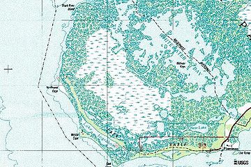
. It is located in southwestern Florida
Florida
Florida is a state in the southeastern United States, located on the nation's Atlantic and Gulf coasts. It is bordered to the west by the Gulf of Mexico, to the north by Alabama and Georgia and to the east by the Atlantic Ocean. With a population of 18,801,310 as measured by the 2010 census, it...
, in Monroe County
Monroe County, Florida
Monroe County is a county located in the state of Florida. As of 2000, the population was 79,589. The U.S. Census Bureau 2006 estimate for the county was 74,737....
, and is part of the Everglades National Park
Everglades National Park
Everglades National Park is a national park in the U.S. state of Florida that protects the southern 25 percent of the original Everglades. It is the largest subtropical wilderness in the United States, and is visited on average by one million people each year. It is the third-largest...
. The cape is a peninsula
Peninsula
A peninsula is a piece of land that is bordered by water on three sides but connected to mainland. In many Germanic and Celtic languages and also in Baltic, Slavic and Hungarian, peninsulas are called "half-islands"....
issuing from the southeastern part of the Florida mainland
Mainland
Mainland is a name given to a large landmass in a region , or to the largest of a group of islands in an archipelago. Sometimes its residents are called "Mainlanders"...
, running west and curving around to the north, reaching Ponce de Leon Bay
Ponce de Leon Bay
Ponce de Leon Bay is a bay on the Gulf of Mexico in southwestern Florida in the United Statesat 81 degrees longitude and 10.6 latitude. The bay is located in Monroe County at the northwestern end of Cape Sable in the Everglades National Park. Ponce de Leon Bay leads into Oyster Bay to the east,...
, at the mouth of the Shark River
Shark River (Florida)
The Shark River is a major distributary of the Harney River in the southwestern portion of Everglades National Park. It is located in Monroe County, Florida, United States. The river is entirely sea level. The mouth of the river is at Ponce de Leon Bay, part of the Gulf of Mexico. The river is only...
. It forms the southern and western margins of Whitewater Bay
Whitewater Bay
Whitewater Bay is an inlet of the Gulf of Mexico in southwestern Florida in the United States. The bay is located entirely within Monroe County north of Cape Sable in the Everglades National Park. Whitewater Bay leads into Oyster Bay to the west, then Ponce de Leon Bay in the Gulf of...
. There are three prominent points on the cape, East Cape, which is the actual southernmost point of the Florida and United States mainland and the location of Lake Ingraham, the southernmost lake in the United States of America, Middle Cape, also known as Palm Point, and Northwest Cape. East Cape is at coordinates 25°07′02"N 81°05′17"W. The cape has many lakes and some magnificent beaches. The cape is home to the Mangrove Diamondback Terrapin
Diamondback terrapin
The diamondback terrapin or simply terrapin, is a species of turtle native to the brackish coastal swamps of the eastern and southern United States. It belongs to the monotypic genus, Malaclemys...
(Malaclemys terrapin rhizophorarum) and the Florida Gopher Tortoise (Gopherus polyphemus
Gopherus polyphemus
The gopher tortoise is a species of the Gopherus genus native to the southeastern United States. The gopher tortoise is seen as a keystone species because it digs burrows that provide shelter for 360 other animal species...
). Before Hurricane Donna
Hurricane Donna
Hurricane Donna in the 1960 Atlantic hurricane season was a Cape Verde-type hurricane which moved across the Leeward Islands, Puerto Rico, Hispanola, Cuba, The Bahamas, and every state on the East Coast of the United States...
(1960) reduced their range, more than 3,000 of the now-endangered Cape Sable Seaside Sparrow
Cape Sable Seaside Sparrow
The Cape Sable Seaside Sparrow is a sub-species of Seaside Sparrow endemic to southern Florida. The largest populations are found in Taylor Slough in Everglade National Park and in the Big Cypress Swamp...
s (Ammodramus maritimus
Seaside Sparrow
The Seaside Sparrow, Ammodramus maritimus, is a small American sparrow. The 11 Ammodramus species inhabit marshes and grasslands.Adults have brownish upperparts with grey on the crown and nape, and a grayish buff colored breast with dark streaks; they have a dark face with grey cheeks, a white...
mirabilis) used the cape.
Nearly the full length of the cape facing Florida Bay
Florida Bay
Florida Bay is the bay located between the southern end of the Florida mainland and the Florida Keys. Its area is variously stated to be , or , or . Nearly all of Florida Bay is included in Everglades National Park. The southern edge, along the Florida Keys is in the Florida Keys National Marine...
and the Gulf of Mexico
Gulf of Mexico
The Gulf of Mexico is a partially landlocked ocean basin largely surrounded by the North American continent and the island of Cuba. It is bounded on the northeast, north and northwest by the Gulf Coast of the United States, on the southwest and south by Mexico, and on the southeast by Cuba. In...
is a fine sand beach extending inland less than 100 yards. Behind the beach in the eastern and middle parts of the cape is a marl
Marl
Marl or marlstone is a calcium carbonate or lime-rich mud or mudstone which contains variable amounts of clays and aragonite. Marl was originally an old term loosely applied to a variety of materials, most of which occur as loose, earthy deposits consisting chiefly of an intimate mixture of clay...
prairie
Prairie
Prairies are considered part of the temperate grasslands, savannas, and shrublands biome by ecologists, based on similar temperate climates, moderate rainfall, and grasses, herbs, and shrubs, rather than trees, as the dominant vegetation type...
, extending from Flamingo
Flamingo, Florida
Flamingo is an unincorporated community and ghost town in Monroe County, Florida, United States. It began as a small coastal settlement on the eastern end of Cape Sable on the southern tip of the Florida peninsula, facing Florida Bay...
to approximately Northwest Point. Inland from the marl prairie, and over all of the northern part of the cape behind the beaches, is a complex of marsh
Marsh
In geography, a marsh, or morass, is a type of wetland that is subject to frequent or continuous flood. Typically the water is shallow and features grasses, rushes, reeds, typhas, sedges, other herbaceous plants, and moss....
es and mangrove
Mangrove
Mangroves are various kinds of trees up to medium height and shrubs that grow in saline coastal sediment habitats in the tropics and subtropics – mainly between latitudes N and S...
covered land. The largest lake on the cape is Lake Ingraham, which is long and narrow, running just behind the beach from near East Cape to past Middle Cape.
There is little evidence of any extensive settlement of Cape Sable by humans. There are adequate sources of fresh water on the cape, and areas of arable land
Arable land
In geography and agriculture, arable land is land that can be used for growing crops. It includes all land under temporary crops , temporary meadows for mowing or pasture, land under market and kitchen gardens and land temporarily fallow...
. There are a few small Indian shell mounds
Midden
A midden, is an old dump for domestic waste which may consist of animal bone, human excrement, botanical material, vermin, shells, sherds, lithics , and other artifacts and ecofacts associated with past human occupation...
there. The Spanish
Spanish Empire
The Spanish Empire comprised territories and colonies administered directly by Spain in Europe, in America, Africa, Asia and Oceania. It originated during the Age of Exploration and was therefore one of the first global empires. At the time of Habsburgs, Spain reached the peak of its world power....
reported a Tequesta
Tequesta
The Tequesta Native American tribe, at the time of first European contact, occupied an area along the southeastern Atlantic coast of Florida...
village on the cape. The pre-Seminole
Seminole
The Seminole are a Native American people originally of Florida, who now reside primarily in that state and Oklahoma. The Seminole nation emerged in a process of ethnogenesis out of groups of Native Americans, most significantly Creeks from what is now Georgia and Alabama, who settled in Florida in...
tribes of south Florida did not practice agriculture
Agriculture
Agriculture is the cultivation of animals, plants, fungi and other life forms for food, fiber, and other products used to sustain life. Agriculture was the key implement in the rise of sedentary human civilization, whereby farming of domesticated species created food surpluses that nurtured the...
, and probably used the cape as a base for fishing and hunting.
Mariners and fishermen visited the Cape to take on fresh water. Hunters also visited the cape, which had more wildlife than the Florida Keys
Florida Keys
The Florida Keys are a coral archipelago in southeast United States. They begin at the southeastern tip of the Florida peninsula, about south of Miami, and extend in a gentle arc south-southwest and then westward to Key West, the westernmost of the inhabited islands, and on to the uninhabited Dry...
. During the Second Seminole War
Second Seminole War
The Second Seminole War, also known as the Florida War, was a conflict from 1835 to 1842 in Florida between various groups of Native Americans collectively known as Seminoles and the United States, part of a series of conflicts called the Seminole Wars...
, residents of the Florida Keys worried about Seminole
Seminole
The Seminole are a Native American people originally of Florida, who now reside primarily in that state and Oklahoma. The Seminole nation emerged in a process of ethnogenesis out of groups of Native Americans, most significantly Creeks from what is now Georgia and Alabama, who settled in Florida in...
s' using Cape Sable and threatening the keys. In 1840 a raiding party, which was believed to have traveled over Cape Sable, attacked and destroyed the settlement on Indian Key
Indian Key State Historic Site
Indian Key State Historic Site is an island within the Florida State Park system located just a few hundred yards southeast of U.S. 1 within the Florida Keys. The island was briefly inhabited in the middle of the 19th century, but is now an uninhabited ghost town...
.
The United States
United States
The United States of America is a federal constitutional republic comprising fifty states and a federal district...
government was concerned that Spanish authorities in Cuba
Cuba
The Republic of Cuba is an island nation in the Caribbean. The nation of Cuba consists of the main island of Cuba, the Isla de la Juventud, and several archipelagos. Havana is the largest city in Cuba and the country's capital. Santiago de Cuba is the second largest city...
were supplying the Seminole to support their resistance. They knew that Cuban fishermen, including the Spanish Indians who had been evacuated to Cuba from Florida in 1821, continued to fish along the southwest Florida
Southwest Florida
Southwest Florida is a region of Florida , United States located along its gulf coast, south of the Tampa Bay area, west of Lake Okeechobee and mostly north of the Everglades...
coast. The United States Army
United States Army
The United States Army is the main branch of the United States Armed Forces responsible for land-based military operations. It is the largest and oldest established branch of the U.S. military, and is one of seven U.S. uniformed services...
established Fort Poinsett on East Cape in 1838 to discourage contacts with the Spanish and to protect the Keys. This fort did not prevent the Seminole attack on Indian Key. In 1856, during the Third Seminole War, the Army established Fort Cross on Middle Cape. Traces of Fort Poinsett could be seen until it was destroyed by the Labor Day Hurricane of 1935
Labor Day Hurricane of 1935
The 1935 Labor Day Hurricane was the strongest tropical cyclone of the 1935 Atlantic hurricane season, and one of the most intense hurricanes to make landfall in the United States in recorded history...
.