

Everglades
Encyclopedia
Subtropics
The subtropics are the geographical and climatical zone of the Earth immediately north and south of the tropical zone, which is bounded by the Tropic of Cancer and the Tropic of Capricorn, at latitudes 23.5°N and 23.5°S...
wetland
Wetland
A wetland is an area of land whose soil is saturated with water either permanently or seasonally. Wetlands are categorised by their characteristic vegetation, which is adapted to these unique soil conditions....
s in the southern portion of the U.S. state of Florida
Florida
Florida is a state in the southeastern United States, located on the nation's Atlantic and Gulf coasts. It is bordered to the west by the Gulf of Mexico, to the north by Alabama and Georgia and to the east by the Atlantic Ocean. With a population of 18,801,310 as measured by the 2010 census, it...
, comprising the southern half of a large watershed
Drainage basin
A drainage basin is an extent or an area of land where surface water from rain and melting snow or ice converges to a single point, usually the exit of the basin, where the waters join another waterbody, such as a river, lake, reservoir, estuary, wetland, sea, or ocean...
. The system begins near Orlando
Orlando, Florida
Orlando is a city in the central region of the U.S. state of Florida. It is the county seat of Orange County, and the center of the Greater Orlando metropolitan area. According to the 2010 US Census, the city had a population of 238,300, making Orlando the 79th largest city in the United States...
with the Kissimmee River
Kissimmee River
The Kissimmee River is a river in south-central Florida, United States.-Course:The Kissimmee River arises in Osceola County as the outflow from East Lake Tohopekaliga, passing through Lake Tohopekaliga, Lake Cypress, Lake Hatchineha and Lake Kissimmee...
, which discharges into the vast but shallow Lake Okeechobee
Lake Okeechobee
Lake Okeechobee , locally referred to as The Lake or The Big O, is the largest freshwater lake in the state of Florida. It is the seventh largest freshwater lake in the United States and the second largest freshwater lake contained entirely within the lower 48 states...
. Water leaving the lake
Lake
A lake is a body of relatively still fresh or salt water of considerable size, localized in a basin, that is surrounded by land. Lakes are inland and not part of the ocean and therefore are distinct from lagoons, and are larger and deeper than ponds. Lakes can be contrasted with rivers or streams,...
in the wet season forms a slow-moving river
River
A river is a natural watercourse, usually freshwater, flowing towards an ocean, a lake, a sea, or another river. In a few cases, a river simply flows into the ground or dries up completely before reaching another body of water. Small rivers may also be called by several other names, including...
60 miles (96.6 km) wide and over 100 miles (160.9 km) long, flowing southward across a limestone
Limestone
Limestone is a sedimentary rock composed largely of the minerals calcite and aragonite, which are different crystal forms of calcium carbonate . Many limestones are composed from skeletal fragments of marine organisms such as coral or foraminifera....
shelf to Florida Bay
Florida Bay
Florida Bay is the bay located between the southern end of the Florida mainland and the Florida Keys. Its area is variously stated to be , or , or . Nearly all of Florida Bay is included in Everglades National Park. The southern edge, along the Florida Keys is in the Florida Keys National Marine...
at the southern end of the state. The Everglades are shaped by water and fire, experiencing frequent flooding in the wet season and drought in the dry season. Writer Marjory Stoneman Douglas
Marjory Stoneman Douglas
Marjory Stoneman Douglas was an American journalist, writer, feminist, and environmentalist known for her staunch defense of the Everglades against efforts to drain it and reclaim land for development...
popularized the term "River of Grass" to describe the sawgrass marshes, part of a complex system of interdependent ecosystem
Ecosystem
An ecosystem is a biological environment consisting of all the organisms living in a particular area, as well as all the nonliving , physical components of the environment with which the organisms interact, such as air, soil, water and sunlight....
s that include cypress
Taxodium
Taxodium is a genus of one to three species of extremely flood-tolerant conifers in the cypress family, Cupressaceae...
swamps, the estuarine
Estuary
An estuary is a partly enclosed coastal body of water with one or more rivers or streams flowing into it, and with a free connection to the open sea....
mangrove
Mangrove
Mangroves are various kinds of trees up to medium height and shrubs that grow in saline coastal sediment habitats in the tropics and subtropics – mainly between latitudes N and S...
forests of the Ten Thousand Islands, tropical hardwood hammocks
Hammock (ecology)
Hammocks are dense stands of hardwood trees that grow on natural rises of only a few inches higher than surrounding marshland that is otherwise too wet to support them. Hammocks are distinctive in that they are formed gradually over thousands of years rising in a wet area through the deposits of...
, pine rockland, and the marine environment of Florida Bay.
Human habitation in the southern portion of the Florida peninsula dates to 15,000 years ago. Two major tribes eventually formed in and around Everglades ecosystems: the Calusa
Calusa
The Calusa were a Native American people who lived on the coast and along the inner waterways of Florida's southwest coast. Calusa society developed from that of archaic peoples of the Everglades region; at the time of European contact, the Calusa were the people of the Caloosahatchee culture...
and the Tequesta
Tequesta
The Tequesta Native American tribe, at the time of first European contact, occupied an area along the southeastern Atlantic coast of Florida...
. After coming into contact with the Spanish in the late 16th century, both tribes declined gradually during the following two centuries. The Seminole
Seminole
The Seminole are a Native American people originally of Florida, who now reside primarily in that state and Oklahoma. The Seminole nation emerged in a process of ethnogenesis out of groups of Native Americans, most significantly Creeks from what is now Georgia and Alabama, who settled in Florida in...
s, a tribe of Creeks who assimilated other peoples into their own, made their living in the Everglades region after being forced there by the U.S. military in the Seminole Wars
Seminole Wars
The Seminole Wars, also known as the Florida Wars, were three conflicts in Florida between the Seminole — the collective name given to the amalgamation of various groups of native Americans and Black people who settled in Florida in the early 18th century — and the United States Army...
of the 19th century.
Draining the Everglades was first suggested in 1848, but was not attempted until 1882. Canals were constructed throughout the first half of the 20th century, and spurred the South Florida economy, prompting land development. However, problems with canals and floods caused by hurricanes forced engineers to rethink their drainage plans. In 1947, Congress formed the Central and Southern Florida Flood Control Project, which built 1400 miles (2,253.1 km) of canals, levees, and water control devices. The South Florida metropolitan area
South Florida metropolitan area
The South Florida metropolitan area, also known as the Miami metropolitan area, and designated the Miami–Fort Lauderdale–Pompano Beach, FL Metropolitan Statistical Area by the U.S...
grew substantially at this time and Everglades water was diverted to cities. Portions of the Everglades were transformed into farmland, where the primary crop was sugarcane
Sugarcane
Sugarcane refers to any of six to 37 species of tall perennial grasses of the genus Saccharum . Native to the warm temperate to tropical regions of South Asia, they have stout, jointed, fibrous stalks that are rich in sugar, and measure two to six metres tall...
. Approximately 50 percent of the original Everglades has been turned into agricultural or urban areas. When the construction of a large airport was proposed 6 miles (9.7 km) north of Everglades National Park
Everglades National Park
Everglades National Park is a national park in the U.S. state of Florida that protects the southern 25 percent of the original Everglades. It is the largest subtropical wilderness in the United States, and is visited on average by one million people each year. It is the third-largest...
, an environmental study predicted it would destroy the South Florida ecosystem. Restoring the Everglades then became a priority.
National and international attention turned to the environment in the 1970s, and UNESCO
UNESCO
The United Nations Educational, Scientific and Cultural Organization is a specialized agency of the United Nations...
and the Ramsar Convention
Ramsar Convention
The Ramsar Convention is an international treaty for the conservation and sustainable utilization of wetlands, i.e., to stem the progressive encroachment on and loss of wetlands now and in the future, recognizing the fundamental ecological functions of wetlands and their economic, cultural,...
designated the Everglades as one of only three wetland areas of global importance. Restoration began in the 1980s with the removal of a canal that straightened the Kissimmee River. The water quality of Lake Okeechobee, a water source for South Florida, became a significant concern. The deterioration of the environment was also linked to the diminishing quality of life in South Florida's urban areas. In 2000, a plan to restore the Everglades was approved by Congress; to date, it is the most expensive and comprehensive environmental repair attempt in history. The Comprehensive Everglades Restoration Plan
Comprehensive Everglades Restoration Plan
The Central and Southern Florida Project, which was first authorized by Congress in 1948, is a multi-purpose project that provides flood control, water supply for municipal, industrial, and agricultural uses, prevention of saltwater intrusion, water supply for Everglades National Park, and...
was signed into law, but the same divisive politics that had affected the region for the previous 50 years have compromised the plan.
Origin of the word
British surveyor John Gerard de Brahm, who mapped the coast of Florida in 1773, called the area "River Glades". Both Marjory Stoneman Douglas and linguist Wallace McMullen suggest that cartographers substituted "Ever" for "River". The name "Everglades" first appeared on a map in 1823, although it was also spelled as "Ever Glades" as late as 1851. The Seminole
Seminole
The Seminole are a Native American people originally of Florida, who now reside primarily in that state and Oklahoma. The Seminole nation emerged in a process of ethnogenesis out of groups of Native Americans, most significantly Creeks from what is now Georgia and Alabama, who settled in Florida in...
s call it Pa-hay-okee, meaning "Grassy Water", and the region was labeled "Pa-hai-okee" on an American military map in 1839, although it appeared as "Ever Glades" throughout the Second Seminole War
Second Seminole War
The Second Seminole War, also known as the Florida War, was a conflict from 1835 to 1842 in Florida between various groups of Native Americans collectively known as Seminoles and the United States, part of a series of conflicts called the Seminole Wars...
.
Geology
The geologyGeology
Geology is the science comprising the study of solid Earth, the rocks of which it is composed, and the processes by which it evolves. Geology gives insight into the history of the Earth, as it provides the primary evidence for plate tectonics, the evolutionary history of life, and past climates...
of South Florida, together with a warm, wet, subtropical climate, provides conditions well-suited for a large marshland ecosystem. Layers of porous and permeable limestone create water-bearing rock
Aquifer
An aquifer is a wet underground layer of water-bearing permeable rock or unconsolidated materials from which groundwater can be usefully extracted using a water well. The study of water flow in aquifers and the characterization of aquifers is called hydrogeology...
and soil that affect the climate, weather, and hydrology
Hydrology
Hydrology is the study of the movement, distribution, and quality of water on Earth and other planets, including the hydrologic cycle, water resources and environmental watershed sustainability...
of South Florida.
The properties of the rock underneath the Everglades can be explained by the geologic history of the state. The crust underneath Florida was at one point part of the African region of the supercontinent Gondwana
Gondwana
In paleogeography, Gondwana , originally Gondwanaland, was the southernmost of two supercontinents that later became parts of the Pangaea supercontinent. It existed from approximately 510 to 180 million years ago . Gondwana is believed to have sutured between ca. 570 and 510 Mya,...
. About 300 million years ago, North America merged with Africa, connecting Florida with North America. Volcanic activity centered around the eastern side of Florida covered the prevalent sedimentary rock
Sedimentary rock
Sedimentary rock are types of rock that are formed by the deposition of material at the Earth's surface and within bodies of water. Sedimentation is the collective name for processes that cause mineral and/or organic particles to settle and accumulate or minerals to precipitate from a solution....
with igneous rock
Igneous rock
Igneous rock is one of the three main rock types, the others being sedimentary and metamorphic rock. Igneous rock is formed through the cooling and solidification of magma or lava...
. Continental rift
Rift
In geology, a rift or chasm is a place where the Earth's crust and lithosphere are being pulled apart and is an example of extensional tectonics....
ing began to separate North America from Gondwana about 180 million years ago. When Florida was part of Africa, it was initially above water, but during the cooler Jurassic Period, the Florida Platform became a shallow marine environment in which sedimentary rocks were deposited. Through the Cretaceous Period, most of Florida remained a tropical sea floor of varying depths. The peninsula has been covered by seawater at least seven times since the bedrock formed.
Limestone and aquifers
Fluctuating sea levels compressed numerous layers of calcium carbonateCalcium carbonate
Calcium carbonate is a chemical compound with the formula CaCO3. It is a common substance found in rocks in all parts of the world, and is the main component of shells of marine organisms, snails, coal balls, pearls, and eggshells. Calcium carbonate is the active ingredient in agricultural lime,...
, sand, and shells. The resulting permeable limestone
Limestone
Limestone is a sedimentary rock composed largely of the minerals calcite and aragonite, which are different crystal forms of calcium carbonate . Many limestones are composed from skeletal fragments of marine organisms such as coral or foraminifera....
formations that developed between 25 million and 70 million years ago created the Floridan Aquifer
Floridan Aquifer
The Floridan Aquifer is a portion of the principal artesian aquifer that extends into Florida and is composed of carbonate rock and located beneath the coastal regions of the Southeastern United States and is one of the world's most productive aquifers. It is under all of Florida as well as ...
, which serves as the main source of fresh water for the northern portion of Florida. However, this aquifer lies beneath thousands of feet of impermeable sedimentary rock from Lake Okeechobee to the southern tip of the peninsula.

Tamiami Formation
The Tamiami Formation is a Late Miocene to Pliocene geologic formation in the southwest Florida peninsula.-Age:Period: NeogeneEpoch: Late Miocene to Pliocene...
, Caloosahatchee Formation, Anastasia Formation
Anastasia Formation
The Anastasia Formation is a geologic formation deposited in Florida during the Late Pleistocene epoch.-Age:Period : QuaternaryEpoch: Pleistocene ~2.558 to 0.012 mya, calculates to a period of...
, Miami Limestone (or Miami Oolite), and the Fort Thompson Formation. The Tamiami Formation is a compression of highly permeable light colored fossiliferous sands and pockets of quartz
Quartz
Quartz is the second-most-abundant mineral in the Earth's continental crust, after feldspar. It is made up of a continuous framework of SiO4 silicon–oxygen tetrahedra, with each oxygen being shared between two tetrahedra, giving an overall formula SiO2. There are many different varieties of quartz,...
, 150 feet (45.7 m) thick. It is named for the Tamiami Trail
Tamiami Trail
The Tamiami Trail is the southernmost of U.S. Highway 41 from State Road 60 in Tampa to U.S. Route 1 in Miami. The road also has the hidden designation of State Road 90....
that follows the upper bedrock of the Big Cypress Swamp, and underlies the southern portion of the Everglades. Between the Tamiami Formation and Lake Okeechobee is the Caloosahatchee Formation, named for the river over it. Much less permeable, this formation is highly calcitic and is composed of sandy shell marl, clay, and sand. Water underneath the Caloosahatchee Formation is typically very mineralized. Both the Tamiami and Caloosahatchee Formations developed during the Pliocene Epoch.
Surrounding the southern part of Lake Okeechobee is the Fort Thompson Formation, made of dense, hard limestone, shells, and sand. Rain water is less likely to erode the limestone to form solution holes—smaller versions of sinkholes that do not intersect with the water table. In this formation the beds are generally impermeable. Underneath the metropolitan areas of Palm Beach County
Palm Beach County, Florida
Palm Beach County is the largest county in the state of Florida in total area, and third in population. As of 2010, the county's estimated population was 1,320,134, making it the twenty-eighth most populous in the United States...
is the Anastasia Formation, composed of shelly limestone, coquina
Coquina
Coquina is a sedimentary rock that is composed either wholly or almost entirely of the transported, abraded, and mechanically sorted fragments of the shells of either molluscs, trilobites, brachiopods, or other invertebrates. For a sediment to be considered to be a coquina, the average size of the...
, and sand representing a former mangrove or salt marsh. The Anastasia Formation is much more permeable and filled with pocks and solution holes. The Fort Thompson and Anastasia Formations, and Miami Limestone and were formed during the Sangamon interglacial period.
The geologic formations that have the most influence on the Everglades are the Miami Limestone and the Fort Thompson Formation. The Miami Limestone forms the floor of the lower Everglades. Close examination of surface rock of the Miami Limestone reveals that it is made up of ooids: tiny formations of egg-shaped concentric shells and calcium carbonate, formed around a single grain of sand. The Miami Limestone was formerly named the Miami Oolite, which comprises facies
Facies
In geology, facies are a body of rock with specified characteristics. Ideally, a facies is a distinctive rock unit that forms under certain conditions of sedimentation, reflecting a particular process or environment....
of ooids and fossilized bryozoan organisms. The unique structure was some of the first material used in housing in early 20th-century South Florida. The composition of this sedimentary formation affects the hydrology, plant life, and wildlife above it: the rock is especially porous and stores water during the dry season in the Everglades, and its chemical composition determines the vegetation prevalent in the region. The Miami Limestone also acts as a dam between Fort Lauderdale
Fort Lauderdale, Florida
Fort Lauderdale is a city in the U.S. state of Florida, on the Atlantic coast. It is the county seat of Broward County. As of the 2010 census, the city had a population of 165,521. It is a principal city of the South Florida metropolitan area, which was home to 5,564,635 people at the 2010...
and Coot Bay.
The metropolitan areas of Miami
Miami, Florida
Miami is a city located on the Atlantic coast in southeastern Florida and the county seat of Miami-Dade County, the most populous county in Florida and the eighth-most populous county in the United States with a population of 2,500,625...
, Fort Lauderdale, and West Palm Beach
West Palm Beach, Florida
West Palm Beach, is a city located on the Atlantic coast in southeastern Florida and is the most populous city in and county seat of Palm Beach County, the third most populous county in Florida with a 2010 population of 1,320,134. The city is also the oldest incorporated municipality in South Florida...
are located on a rise in elevation along the eastern coast of Florida, called the Eastern Coastal Ridge, that was formed as waves compressed ooids into a single formation. Along the western border of the Big Cypress Swamp is the Immokolee Ridge (or Immokolee Rise), a slight rise of compressed sand that divides the runoff between the Caloosahatchee River and The Big Cypress. This slight rise in elevation on both sides of the Everglades creates a basin, and forces water that overflows Lake Okeechobee to creep towards the southwest.
Under both the Miami Limestone formation and the Fort Thompson limestone is a surface aquifer that serves as the South Florida metropolitan area
South Florida metropolitan area
The South Florida metropolitan area, also known as the Miami metropolitan area, and designated the Miami–Fort Lauderdale–Pompano Beach, FL Metropolitan Statistical Area by the U.S...
's fresh water source, called the Biscayne Aquifer
Biscayne Aquifer
The Biscayne Aquifer, named after Biscayne Bay, is a surficial aquifer. It is a shallow layer of highly permeable limestone under a portion of South Florida...
. Rainfall and stored water in the Everglades replenish the Biscayne Aquifer directly.
With the rise of sea levels that occurred during the Pleistocene
Pleistocene
The Pleistocene is the epoch from 2,588,000 to 11,700 years BP that spans the world's recent period of repeated glaciations. The name pleistocene is derived from the Greek and ....
approximately 17,000 years ago, the runoff of water from Lake Okeechobee slowed and created the vast marshland that is now known as the Everglades. Slower runoff also created an accumulation of almost 18 feet (5.5 m) of peat
Peat
Peat is an accumulation of partially decayed vegetation matter or histosol. Peat forms in wetland bogs, moors, muskegs, pocosins, mires, and peat swamp forests. Peat is harvested as an important source of fuel in certain parts of the world...
in the area. The presence of such peat deposits, dated to about 5,000 years ago, is evidence that widespread flooding had occurred by then.
Hydrology

Kissimmee River
The Kissimmee River is a river in south-central Florida, United States.-Course:The Kissimmee River arises in Osceola County as the outflow from East Lake Tohopekaliga, passing through Lake Tohopekaliga, Lake Cypress, Lake Hatchineha and Lake Kissimmee...
, Caloosahatchee
Caloosahatchee River
The Caloosahatchee River is a river on the southwest Gulf Coast of Florida in the United States, approximately long. It drains rural areas on the northern edge of the Everglades northwest of Miami...
, Myakka
Myakka River
The Myakka River is a river in southwestern Florida. It arises near the Hardee-Manatee county line and flows southwest and then southeast through Manatee, Sarasota and Charlotte counties to Charlotte Harbor, an arm of the Gulf of Mexico. The river is long and has a drainage basin of...
, and Peace River
Peace River (Florida)
The Peace River is a river in the southwestern part of the Florida peninsula, in the U.S.A.. It originates at the juncture of Saddle Creek and Peace Creek northeast of Bartow in Polk County and flows south through Hardee County to Arcadia in DeSoto County and then southwest into the Charlotte...
s in central Florida. The Kissimmee River is a broad floodplain
Floodplain
A floodplain, or flood plain, is a flat or nearly flat land adjacent a stream or river that stretches from the banks of its channel to the base of the enclosing valley walls and experiences flooding during periods of high discharge...
that empties directly into Lake Okeechobee, which at 730 square miles (1,890.7 km²) with an average depth of 9 feet (2.7 m), is a vast but shallow lake. Soil deposits in the Everglades basin indicate that peat is deposited where the land is flooded consistently throughout the year. Calcium deposits are left behind when flooding is shorter. The deposits occur in areas where water rises and falls depending on rainfall, as opposed to water being stored in the rock from one year to the next. Calcium deposits are present where more limestone is exposed.
The area from Orlando
Orlando, Florida
Orlando is a city in the central region of the U.S. state of Florida. It is the county seat of Orange County, and the center of the Greater Orlando metropolitan area. According to the 2010 US Census, the city had a population of 238,300, making Orlando the 79th largest city in the United States...
to the tip of the Florida peninsula was at one point a single drainage unit. When rainfall exceeded the capacity of Lake Okeechobee and the Kissimmee River floodplain, it spilled over and flowed in a southwestern direction to empty into Florida Bay
Florida Bay
Florida Bay is the bay located between the southern end of the Florida mainland and the Florida Keys. Its area is variously stated to be , or , or . Nearly all of Florida Bay is included in Everglades National Park. The southern edge, along the Florida Keys is in the Florida Keys National Marine...
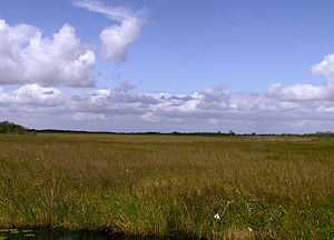
. Prior to urban and agricultural development in Florida, the Everglades began at the southern edge of Lake Okeechobee and flowed for approximately 100 miles (160.9 km), emptying into the Gulf of Mexico. The limestone shelf is wide and slightly angled instead of having a narrow, deep channel characteristic of most rivers. The vertical gradient from Lake Okeechobee to Florida Bay is about 2 inches (5.1 cm) per mile, creating an almost 60 miles (96.6 km) wide expanse of river that travels about half a mile (0.8 km) a day. This slow movement of a broad, shallow river is known as sheetflow, and gives the Everglades its nickname, River of Grass. Water leaving Lake Okeechobee may require months or years to reach its final destination, Florida Bay. The sheetflow travels so slowly that water is typically stored from one wet season to the next in the porous limestone substrate. The ebb and flow of water has shaped the land and every ecosystem in South Florida throughout the Everglades' estimated 5,000 years of existence. The motion of water defines plant communities and how animals adapt to their habitats and food sources.
Climate

The climate of South Florida is noted for its variability, as average annual temperatures range from 60 °F (15.6 °C) to 80 °F (26.7 °C). Temperatures in summer months typically exceed 90 °F (32.2 °C), although coastal locations are cooled by winds from the Gulf of Mexico
Gulf of Mexico
The Gulf of Mexico is a partially landlocked ocean basin largely surrounded by the North American continent and the island of Cuba. It is bounded on the northeast, north and northwest by the Gulf Coast of the United States, on the southwest and south by Mexico, and on the southeast by Cuba. In...
and the Atlantic Ocean. Freezing in winter months occurs with varying severity and frequency. The most severe episode of freezing in the region's recorded history occurred in two weeks of January 2010, resulting in effects similar to the destruction of a hurricane or substantial wildfire. The region's subtropical to tropical climate features a 7-month wet season
Wet season
The the wet season, or rainy season, is the time of year, covering one or more months, when most of the average annual rainfall in a region occurs. The term green season is also sometimes used as a euphemism by tourist authorities. Areas with wet seasons are dispersed across portions of the...
from April through October, when 75 percent of precipitation is related to tropical cyclone
Tropical cyclone
A tropical cyclone is a storm system characterized by a large low-pressure center and numerous thunderstorms that produce strong winds and heavy rain. Tropical cyclones strengthen when water evaporated from the ocean is released as the saturated air rises, resulting in condensation of water vapor...
s and thunderstorm
Thunderstorm
A thunderstorm, also known as an electrical storm, a lightning storm, thundershower or simply a storm is a form of weather characterized by the presence of lightning and its acoustic effect on the Earth's atmosphere known as thunder. The meteorologically assigned cloud type associated with the...
s. Only 25 percent of the annual precipitation falls during the dry season
Dry season
The dry season is a term commonly used when describing the weather in the tropics. The weather in the tropics is dominated by the tropical rain belt, which oscillates from the northern to the southern tropics over the course of the year...
from November to March, usually sparked by cold front
Cold front
A cold front is defined as the leading edge of a cooler mass of air, replacing a warmer mass of air.-Development of cold front:The cooler and denser air wedges under the less-dense warmer air, lifting it...
s tracking southward. Annual rainfall averages approximately 62 inches (157.5 cm), with the Eastern Coastal Ridge receiving the majority of precipitation and the area surrounding Lake Okeechobee receiving about 48 inches (121.9 cm).
Unlike any other wetland system on earth, the Everglades are sustained primarily by the atmosphere. Evapotranspiration
Evapotranspiration
Evapotranspiration is a term used to describe the sum of evaporation and plant transpiration from the Earth's land surface to atmosphere. Evaporation accounts for the movement of water to the air from sources such as the soil, canopy interception, and waterbodies...
—a term used to describe the sum of evaporation and plant transpiration from the Earth's land surface to atmosphere—associated with thunderstorms, is the key mechanism by which water leaves the region. During a year unaffected by drought, the rate may reach 40 inches (101.6 cm) a year. When droughts take place, the rate may peak at over 50 inches (127 cm), and exceed the amount of rainfall. As water leaves an area through evaporation from groundwater or from plant matter, activated primarily by solar energy, it is then moved by wind patterns to other areas that border or flow into the Everglades watershed system. Evapotranspiration is responsible for approximately 70–90 percent of water entering undeveloped wetland regions in the Everglades.
Precipitation during the wet season is primarily caused by thunderstorms formed from Bermuda High
Azores High
The Azores High is a large subtropical semi-permanent centre of high atmospheric pressure found near the Azores in the Atlantic Ocean, at the Horse latitudes...
pressure systems, blown ashore with the anti-clockwise flow. However, precipitation levels are often twice as high from August to October due to tropical depressions, storms, and hurricanes. Storm systems are significantly affected by El Niño and other global climate
Climate
Climate encompasses the statistics of temperature, humidity, atmospheric pressure, wind, rainfall, atmospheric particle count and other meteorological elemental measurements in a given region over long periods...
factors: between 1951 and 1980, precipitation in South Florida varied between 34 inches (86.4 cm) and 88 inches (223.5 cm). Tropical storms average one a year, and major hurricanes about once every ten years. Between 1871 and 1981, 138 tropical cyclones struck directly over or close to the Everglades. Strong winds from these storms disperse plant seeds and replenish mangrove
Mangrove
Mangroves are various kinds of trees up to medium height and shrubs that grow in saline coastal sediment habitats in the tropics and subtropics – mainly between latitudes N and S...
forests, coral reefs, and other ecosystems. Dramatic fluctuations in precipitation are characteristic of the South Florida climate. Drought
Drought
A drought is an extended period of months or years when a region notes a deficiency in its water supply. Generally, this occurs when a region receives consistently below average precipitation. It can have a substantial impact on the ecosystem and agriculture of the affected region...
s, flood
Flood
A flood is an overflow of an expanse of water that submerges land. The EU Floods directive defines a flood as a temporary covering by water of land not normally covered by water...
s, freezing, and tropical cyclones are part of the natural water system in the Everglades.
| Period | Mean | Maximum | Minimum |
|---|---|---|---|
| Annual | 51.9 inches (131.8 cm) | 77.5 inches (196.9 cm) | 36.7 inches (93.2 cm) |
| Wet season | 34.5 inches (87.6 cm) | 53.5 inches (135.9 cm) | 23.4 inches (59.4 cm) |
| Dry season | 17.4 inches (44.2 cm) | 30.9 inches (78.5 cm) | 7.3 inches (18.5 cm) |
Formative and sustaining processes
The Everglades are a complex system of interdependent ecosystems. Marjory Stoneman DouglasMarjory Stoneman Douglas
Marjory Stoneman Douglas was an American journalist, writer, feminist, and environmentalist known for her staunch defense of the Everglades against efforts to drain it and reclaim land for development...
described the area as a "River of Grass" in 1947, though that metaphor represents only a portion of the system. The area recognized as the Everglades, prior to drainage, was a web of marshes and prairies 4000 square miles (10,360 km²) in size. Borders between ecosystems are subtle or imperceptible. These systems shift, grow and shrink, die, or reappear within years or decades. Geologic factors, climate, and the frequency of fire help to create, maintain, or replace the ecosystems in the Everglades.
Water
Last Glacial Maximum
The Last Glacial Maximum refers to a period in the Earth's climate history when ice sheets were at their maximum extension, between 26,500 and 19,000–20,000 years ago, marking the peak of the last glacial period. During this time, vast ice sheets covered much of North America, northern Europe and...
, 21,000 years ago, continental ice sheets retreated and sea levels rose. This submerged portions of the Florida peninsula and caused the water table
Water table
The water table is the level at which the submarine pressure is far from atmospheric pressure. It may be conveniently visualized as the 'surface' of the subsurface materials that are saturated with groundwater in a given vicinity. However, saturated conditions may extend above the water table as...
to rise. Fresh water saturated the limestone that underlies the Everglades, eroding some of it away, and created spring
Spring (hydrosphere)
A spring—also known as a rising or resurgence—is a component of the hydrosphere. Specifically, it is any natural situation where water flows to the surface of the earth from underground...
s and sinkhole
Sinkhole
A sinkhole, also known as a sink, shake hole, swallow hole, swallet, doline or cenote, is a natural depression or hole in the Earth's surface caused by karst processes — the chemical dissolution of carbonate rocks or suffosion processes for example in sandstone...
s. The abundance of fresh water allowed new vegetation to take root, and formed convective thunderstorms over the land through evaporation.
As rain continued to fall, the slightly acidic rainwater dissolved
Solution
In chemistry, a solution is a homogeneous mixture composed of only one phase. In such a mixture, a solute is dissolved in another substance, known as a solvent. The solvent does the dissolving.- Types of solutions :...
the limestone. As limestone wore away, the groundwater came into contact with the land surface and created a massive wetland ecosystem. Although the region appears flat, weathering
Weathering
Weathering is the breaking down of rocks, soils and minerals as well as artificial materials through contact with the Earth's atmosphere, biota and waters...
of the limestone created slight valleys and plateaus in some areas. These plateaus rise and fall only a few inches, but on the subtle South Florida topography these small variations affect both the flow of water and the types of vegetation that can take hold.
Rock
The underlying bedrock or limestone of the Everglades basin affects the hydroperiod, or how long an area within the region stays flooded throughout the year. Longer hydroperiods are possible in areas that were submerged beneath seawater for longer periods of time, while the geology of Florida was forming. More water is held within the porous ooids and limestone than older types of rock that spent more time above sea level. A hydroperiod of ten months or more fosters growth of sawgrass, whereas a shorter hydroperiod of six months or less promotes beds of periphytonPeriphyton
Periphyton are a complex mixture of algae, cyanobacteria, heterotrophic microbes, and detritus that are attached to submerged surfaces in most aquatic ecosystems. It serves as an important food source for invertebrates, tadpoles, and some fish. It can also absorb contaminants; removing them from...
, a growth of algae and other microscopic organisms. There are only two types of soil in the Everglades, peat
Peat
Peat is an accumulation of partially decayed vegetation matter or histosol. Peat forms in wetland bogs, moors, muskegs, pocosins, mires, and peat swamp forests. Peat is harvested as an important source of fuel in certain parts of the world...
and marl
Marl
Marl or marlstone is a calcium carbonate or lime-rich mud or mudstone which contains variable amounts of clays and aragonite. Marl was originally an old term loosely applied to a variety of materials, most of which occur as loose, earthy deposits consisting chiefly of an intimate mixture of clay...
. Where there are longer hydroperiods, peat builds up over hundreds or thousands of years due to many generations of decaying plant matter. Where periphyton grows, the soil develops into marl, which is more calcitic in composition.
Initial attempts at developing agriculture near Lake Okeechobee were successful, but the nutrients in the peat were rapidly removed. In a process called soil subsidence
Subsidence
Subsidence is the motion of a surface as it shifts downward relative to a datum such as sea-level. The opposite of subsidence is uplift, which results in an increase in elevation...
, oxidation of peat causes loss of volume. Bacteria decompose dead sawgrass slowly underwater without oxygen. When the water was drained in the 1920s and bacteria interacted with oxygen, an aerobic reaction occurred. Microorganisms degraded the peat into carbon dioxide
Carbon dioxide
Carbon dioxide is a naturally occurring chemical compound composed of two oxygen atoms covalently bonded to a single carbon atom...
and water. Some of the peat was burned by settlers to clear the land. Some homes built in the areas of early farms had to have their foundations moved to stilts as the peat deteriorated; other areas lost approximately 8 feet (2.4 m) of soil depth.
Fire
Fire is an important element in the maintenance of the Everglades. The majority of fires are caused by lightningLightning
Lightning is an atmospheric electrostatic discharge accompanied by thunder, which typically occurs during thunderstorms, and sometimes during volcanic eruptions or dust storms...
strikes from thunderstorms during the wet season. Their effects are largely superficial, and serve to foster specific plant growth: sawgrass
Cladium
Cladium is a genus of large sedges, with a worldwide distribution in tropical and temperate regions...
will burn above water, but the roots are preserved underneath. Fire in the sawgrass marshes serves to keep out larger bushes and trees, and releases nutrients from decaying plant matter more efficiently than decomposition
Decomposition
Decomposition is the process by which organic material is broken down into simpler forms of matter. The process is essential for recycling the finite matter that occupies physical space in the biome. Bodies of living organisms begin to decompose shortly after death...
. Whereas in the wet season, dead plant matter and the tips of grasses and trees are burned, in the dry season the fire may be fed by organic peat and burn deeply, destroying root systems. Fires are confined by existing water and rainfall. It takes approximately 225 years for one foot (.30 m) of peat to develop, but in some locations the peat is less dense than it should be for the 5,000 years of the Everglades' existence. Scientists indicate fire as the cause; it is also cited as the reason for the black color of Everglades muck. Layers of charcoal
Charcoal
Charcoal is the dark grey residue consisting of carbon, and any remaining ash, obtained by removing water and other volatile constituents from animal and vegetation substances. Charcoal is usually produced by slow pyrolysis, the heating of wood or other substances in the absence of oxygen...
have been detected in the peat in portions of the Everglades that indicate the region endured severe fires for years at a time, although this trend seems to have abated since the last occurrence in 940 BCE.
Ecosystems

Sawgrass marshes and sloughs
Several ecosystems are present in the Everglades, and boundaries between them are subtle or do not exist. The primary feature of the Everglades is the sawgrassCladium
Cladium is a genus of large sedges, with a worldwide distribution in tropical and temperate regions...
marsh. The iconic water and sawgrass combination in the shallow river 100 miles (160.9 km) long and 60 miles (96.6 km) wide that spans from Lake Okeechobee to Florida Bay is often referred to as the "true Everglades" or just "the Glades". Prior to the first drainage attempts in 1905, the sheetflow occupied nearly a third of the lower Florida peninsula. Sawgrass thrives in the slowly moving water, but may die in unusually deep floods if oxygen is unable to reach its roots, and it is particularly vulnerable immediately after a fire. The hydroperiod for the marsh is at least nine months, and can last longer. Where sawgrass grows densely, few animals or other plants live, although alligator
Alligator
An alligator is a crocodilian in the genus Alligator of the family Alligatoridae. There are two extant alligator species: the American alligator and the Chinese alligator ....
s choose these locations for nesting. Where there is more room, periphyton
Periphyton
Periphyton are a complex mixture of algae, cyanobacteria, heterotrophic microbes, and detritus that are attached to submerged surfaces in most aquatic ecosystems. It serves as an important food source for invertebrates, tadpoles, and some fish. It can also absorb contaminants; removing them from...
grows. Periphyton supports larval insects and amphibians, which in turn are used as food by birds, fish, and reptiles. It also absorbs calcium
Calcium
Calcium is the chemical element with the symbol Ca and atomic number 20. It has an atomic mass of 40.078 amu. Calcium is a soft gray alkaline earth metal, and is the fifth-most-abundant element by mass in the Earth's crust...
from water, which adds to the calcitic composition of the marl.
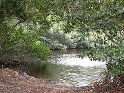
Sloughs, or free-flowing channels of water, develop in between sawgrass prairies. Sloughs are about 3 foot (0.9144 m) deeper than sawgrass marshes, and may stay flooded for at least 11 months out of the year and sometimes multiple years in a row. Aquatic animals such as turtles, alligators, snakes, and fish thrive in sloughs; they usually feed on aquatic invertebrates. Submerged and floating plants grow here, such as bladderwort (Utricularia), waterlily (Nymphaeaceae
Nymphaeaceae
Nymphaeaceae is a family of flowering plants. Members of this family are commonly called water lilies and live in freshwater areas in temperate and tropical climates around the world. The family contains eight genera. There are about 70 species of water lilies around the world. The genus...
), and spatterdock (Nuphar lutea
Nuphar lutea
Nuphar lutea is an aquatic plant of the family Nymphaeaceae, native to temperate regions of Europe, northwest Africa, and western Asia.-Growth:...
). Major sloughs in the Everglades system include the Shark River
Shark River (Florida)
The Shark River is a major distributary of the Harney River in the southwestern portion of Everglades National Park. It is located in Monroe County, Florida, United States. The river is entirely sea level. The mouth of the river is at Ponce de Leon Bay, part of the Gulf of Mexico. The river is only...
Slough flowing out to Florida Bay, Lostmans River Slough bordering The Big Cypress, and Taylor Slough
Taylor Slough
Taylor Slough, located in the southeastern corner of the Florida Everglades, along with the much larger Shark River Slough farther to the west, are the principal natural drainages for the freshwater Everglades....
in the eastern Everglades.
Wet prairies are slightly elevated like sawgrass marshes, but with greater plant diversity. The surface is covered in water only three to seven months of the year, and the water is, on average, shallow at only 4 inches (10.2 cm) deep. When flooded, the marl can support a variety of water plants. Solution holes
Sinkhole
A sinkhole, also known as a sink, shake hole, swallow hole, swallet, doline or cenote, is a natural depression or hole in the Earth's surface caused by karst processes — the chemical dissolution of carbonate rocks or suffosion processes for example in sandstone...
, or deep pits where the limestone has worn away, may remain flooded even when the prairies are dry, and they support aquatic invertebrates such as crayfish
Crayfish
Crayfish, crawfish, or crawdads – members of the superfamilies Astacoidea and Parastacoidea – are freshwater crustaceans resembling small lobsters, to which they are related...
and snails, and larval amphibians which feed young wading birds. These regions tend to border between sloughs and sawgrass marshes.
Alligators have created a niche in wet prairies. With their claws and snouts they dig at low spots and create ponds free of vegetation that remain submerged throughout the dry season. Alligator holes are integral to the survival of aquatic invertebrates, turtles, fish, small mammals, and birds during extended drought periods. The alligators then feed upon some of the animals that come to the hole.
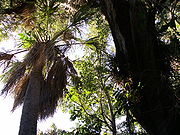
Tropical hardwood hammock
Hammock (ecology)
Hammocks are dense stands of hardwood trees that grow on natural rises of only a few inches higher than surrounding marshland that is otherwise too wet to support them. Hammocks are distinctive in that they are formed gradually over thousands of years rising in a wet area through the deposits of...
s. They may range from one (4,000 m²) to ten acres (40,000 m²) in area, and appear in freshwater sloughs, sawgrass prairies, or pineland. Hammocks are slightly elevated on limestone plateaus risen several inches above the surrounding peat, or they may grow on land that has been unharmed by deep peat fires. Hardwood hammocks exhibit a mixture of subtropical and hardwood trees, such as Southern live oak (Quercus virginiana), gumbo limbo (Bursera simaruba
Bursera simaruba
Bursera simaruba, commonly known as the Gumbo-limbo, is a tree species in the family Burseraceae, native to tropical regions of the Americas from the southeasternmost United States south through Mexico and the Caribbean to Brazil and Venezuela...
), royal palm (Roystonea
Roystonea
Roystonea is a genus of eleven species of monoecious palms, native to the Caribbean Islands, and the adjacent coasts of Florida, Central and South America. Commonly known as the royal palms, the genus was named for Roy Stone, a U.S. Army engineer...
), and bustic (Dipholis salicifolia
Dipholis salicifolia
Dipholis salicifolia, commonly called willow bustic or White Bully, is a species of flowering plant native to Florida, the West Indies and Central America. It was previously considered a member of the genus Sideroxylon, with the binomial Sideroxylon salicifolium...
) that grow in very dense clumps. Near the base, sharp saw palmettos (Serenoa repens) flourish, making the hammocks very difficult for people to penetrate, though small mammals, reptiles and amphibians find these islands an ideal habitat. Water in sloughs flows around the islands, creating moat
Moat
A moat is a deep, broad ditch, either dry or filled with water, that surrounds a castle, other building or town, historically to provide it with a preliminary line of defence. In some places moats evolved into more extensive water defences, including natural or artificial lakes, dams and sluices...
s. Though some ecosystems are maintained and promoted by fire, hammocks may take decades or centuries to recover. The moats around the hammocks protect the trees. The trees are limited in height by weather factors such as frost, lightning, and wind; the majority of trees in hammocks grow no higher than 55 feet (16.8 m).
Pineland
Some of the dryest land in the Everglades is pineland (also called pine rockland) ecosystem, located in the highest part of the Everglades with little to no hydroperiod. Some floors, however, may have flooded solution holes or puddles for a few months at a time. The most significant feature of the pineland is the single species of South Florida slash pine (Pinus elliotti). Pineland communities require fire to maintain them, and the trees have several adaptations that simultaneously promote and resist fire. The sandy floor of the pine forest is covered with dry pine needles that are highly flammable. South Florida slash pines are insulated by their bark to protect them from heat. Fire eliminates competing vegetation on the forest floor, and opens pine cones to germinate seeds. A period without significant fire can turn pineland into a hardwood hammock as larger trees overtake the slash pines. The understoryUnderstory
Understory is the term for the area of a forest which grows at the lowest height level below the forest canopy. Plants in the understory consist of a mixture of seedlings and saplings of canopy trees together with understory shrubs and herbs...
shrubs in pine rocklands are the fire-resistant saw palmetto (Serenoa repens), cabbage palm (Sabal palmetto
Sabal palmetto
Sabal palmetto, also known as cabbage palm, palmetto, cabbage palmetto, palmetto palm, blue palmetto, Carolina palmetto, common palmetto, swamp cabbage and sabal palm, is one of 15 species of palmetto palm . It is native to the southeastern United States, Cuba, and the Bahamas...
), and West Indian lilac (Tetrazygia bicolor
Tetrazygia bicolor
Tetrazygia bicolor is a species flowering plant in the glory bush family, Melastomataceae, that is native to southern Florida in the United States and the Caribbean. Common names include Florida Tetrazygia and West Indian Lilac.T. bicolor is a shrub that reaches a height of...
). The most diverse group of plants in the pine community are the herbs, of which there are two dozen species. These plants contain tuber
Tuber
Tubers are various types of modified plant structures that are enlarged to store nutrients. They are used by plants to survive the winter or dry months and provide energy and nutrients for regrowth during the next growing season and they are a means of asexual reproduction...
s and other mechanisms that allow them to sprout quickly after being charred.
Prior to urban development of the South Florida region, pine rocklands covered approximately 161660 acres (654.2 km²) in Miami-Dade County
Miami-Dade County, Florida
Miami-Dade County is a county located in the southeastern part of the state of Florida. As of 2010 U.S. Census, the county had a population of 2,496,435, making it the most populous county in Florida and the eighth-most populous county in the United States...
. Within Everglades National Park, 19840 acres (80.3 km²) of pine forests are protected, but outside the park, 1780 acres (7.2 km²) of pine communities remained as of 1990, averaging 12.1 acres (48,967 m²) in area. The misunderstanding of the role of fire also played a part in the disappearance of pine forests in the area, as natural fires were put out and pine rocklands transitioned into hardwood hammocks. Prescribed fires occur in Everglades National Park in pine rocklands every three to seven years.
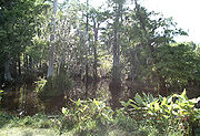
Cypress
Collier County, Florida
Collier County is a county located in the U.S. state of Florida. As of 2000, the population was 251,377. The U.S. Census Bureau 2007 estimate for the county is 315,839...
. The Big Cypress Swamp is located to the west of the sawgrass prairies and sloughs, and it is commonly called "The Big Cypress." The name refers to its area rather than the height or diameter of the trees; at its most conservative estimate, the swamp measures 1200 square miles (3,108 km²), but the hydrologic boundary
Hydrography
Hydrography is the measurement of the depths, the tides and currents of a body of water and establishment of the sea, river or lake bed topography and morphology. Normally and historically for the purpose of charting a body of water for the safe navigation of shipping...
of The Big Cypress can be calculated at over 2400 square miles (6,216 km²). Most of The Big Cypress sits atop a bedrock covered by a thinner layer of limestone. The limestone underneath the Big Cypress contains quartz
Quartz
Quartz is the second-most-abundant mineral in the Earth's continental crust, after feldspar. It is made up of a continuous framework of SiO4 silicon–oxygen tetrahedra, with each oxygen being shared between two tetrahedra, giving an overall formula SiO2. There are many different varieties of quartz,...
, which creates sandy soil that hosts a variety of vegetation different from what is found in other areas of the Everglades. The basin for The Big Cypress receives on average 55 inches (139.7 cm) of water in the wet season.
Though The Big Cypress is the largest growth of cypress swamps in South Florida, cypress swamps can be found near the Atlantic Coastal Ridge and between Lake Okeechobee and the Eastern flatwoods, as well as in sawgrass marshes. Cypresses are conifers that are uniquely adapted to thrive in flooded conditions, with buttressed trunks and root projections that protrude out of the water, called "knees". Cypress trees grow in formations with the tallest and thickest trunks in the center, rooted in the deepest peat. As the peat thins out, cypresses grow smaller and thinner, giving the small forest the appearance of a dome from the outside. They also grow in strands, slightly elevated on a ridge of limestone bordered on either side by sloughs. Other hardwood trees can be found in cypress domes, such as red maple, swamp bay
Persea
Persea is a genus of about 150 species of evergreen trees belonging to the laurel family, Lauraceae. The best-known member of the genus is the avocado, P. americana, widely cultivated in subtropical regions for its large, edible fruit.-Overview:...
, and pop ash
Ash tree
Fraxinus is a genus flowering plants in the olive and lilac family, Oleaceae. It contains 45-65 species of usually medium to large trees, mostly deciduous though a few subtropical species are evergreen. The tree's common English name, ash, goes back to the Old English æsc, while the generic name...
. If cypresses are removed, the hardwoods take over, and the ecosystem is recategorized as a mixed swamp forest.
Mangrove and Coastal prairie
There are three species of trees that are considered mangroves: red (Rhizophora mangle
Rhizophora mangle
Rhizophora mangle, known as the red mangrove, is distributed in estuarine ecosystems throughout the tropics. Its viviparous "seeds," in actuality called propagules, become fully mature plants before dropping off the parent tree...
), black (Avicennia germinans
Avicennia germinans
Avicennia germinans, commonly known as the black mangrove, is a species of flowering plant in the acanthus family, Acanthaceae.A. germinans grows in tropical and subtropical regions of the Americas, on both Atlantic and Pacific coasts, and on the Atlantic coast of tropical Africa, where it thrives...
), and white (Laguncularia racemosa
Laguncularia racemosa
Laguncularia racemosa is a species of flowering plant in the leadwood tree family, Combretaceae...
), although all are from different families. All grow in oxygen-poor soil, can survive drastic water level changes, and are tolerant of salt, brackish, and fresh water. All three mangrove species are integral to coastline protection during severe storms. Red mangroves have the farthest-reaching roots, trapping sediments that help build coastlines after and between storms. All three types of trees absorb the energy of waves and storm surge
Storm surge
A storm surge is an offshore rise of water associated with a low pressure weather system, typically tropical cyclones and strong extratropical cyclones. Storm surges are caused primarily by high winds pushing on the ocean's surface. The wind causes the water to pile up higher than the ordinary sea...
s. Everglades mangroves also serve as nurseries for crustaceans and fish, and rookeries for birds. The region supports Tortugas pink shrimp (Farfantepenaeus duorarum) and stone crab (Menippe mercenaria) industries; between 80 to 90 percent of commercially harvested crustacean species in Florida's salt waters are born or spend time near the Everglades.
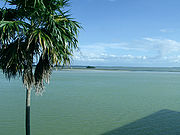
Florida Bay
Florida Bay
Florida Bay is the bay located between the southern end of the Florida mainland and the Florida Keys. Its area is variously stated to be , or , or . Nearly all of Florida Bay is included in Everglades National Park. The southern edge, along the Florida Keys is in the Florida Keys National Marine...
are considered to be a part of the Everglades watershed and one of the ecosystems connected to and affected by the Everglades as a whole. More than 800 square miles (2,072 km²) of Florida Bay is protected by Everglades National Park
Everglades National Park
Everglades National Park is a national park in the U.S. state of Florida that protects the southern 25 percent of the original Everglades. It is the largest subtropical wilderness in the United States, and is visited on average by one million people each year. It is the third-largest...
, representing the largest body of water in the park boundaries. There are approximately a hundred keys
Cay
A cay , also spelled caye or key, is a small, low-elevation, sandy island formed on the surface of coral reefs. Cays occur in tropical environments throughout the Pacific, Atlantic and Indian Oceans , where they provide habitable and agricultural land for hundreds of thousands of people...
in Florida Bay, many of which are mangrove forests. The fresh water coming into Florida Bay from the Everglades creates perfect conditions for vast beds of turtle grass
Seagrass
Seagrasses are flowering plants from one of four plant families , all in the order Alismatales , which grow in marine, fully saline environments.-Ecology:...
and algae formations that are the foundation for animal life in the bay. Sea turtle
Sea turtle
Sea turtles are marine reptiles that inhabit all of the world's oceans except the Arctic.-Distribution:...
s and manatee
Manatee
Manatees are large, fully aquatic, mostly herbivorous marine mammals sometimes known as sea cows...
s eat the grass, while invertebrate animals, such as worms, clams and other mollusks eat the algae formations and microscopic plankton. Female sea turtles return annually to nest on the shore, and manatees spend the winter months in the warmer water of the bay. Sea grasses also serve to stabilize the sea beds and protect shorelines from erosion by absorbing energy from waves.
Native Americans
People arrived in the Florida peninsula approximately 15,000 years ago. Paleo-Indians came to Florida probably following large game that included giant sloths, saber-toothed catSaber-toothed cat
Saber-toothed cat or Sabre-toothed cat refers to the extinct subfamilies of Machairodontinae , Barbourofelidae , and Nimravidae as well as two families related to marsupials that were found worldwide from the Eocene Epoch to the end of the Pleistocene Epoch ,...
s, and spectacled bear
Spectacled Bear
The spectacled bear , also known as the Andean bear and locally as ukuko, jukumari or ucumari, is the last remaining short-faced bear and the closest living relative to the Florida spectacled bear and short-faced bears of the Middle Pleistocene to Late Pleistocene age.The spectacled bear is a...
s. They found an arid landscape that supported plants and animals adapted for desert conditions. However, 6,500 years ago, climate changes brought a wetter landscape; large animals became extinct in Florida, and the Paleo-Indians slowly adapted and became the Archaic peoples. They conformed to the environmental changes, and created many tools with the various resources available to them. During the Late Archaic period, the climate became wetter again, and approximately 3000 BCE the rise of water tables allowed an increase in population and cultural activity. Florida Indians developed into three distinct but similar cultures that were named for the bodies of water near where they were located: Okeechobee
Belle Glade culture
The Belle Glade culture, or Okeechobee culture, is an archaeological culture that existed from as early as 1000 BCE until about 1700 in the area surrounding Lake Okeechobee and in the Kissimmee River valley in the U.S...
, Caloosahatchee
Caloosahatchee culture
The Caloosahatchee culture is an archaeological culture on the Gulf coast of Southwest Florida that lasted from about 500 to 1750 CE. Its territory consisted of the coast from Estero Bay to Charlotte Harbor and inland about halfway to Lake Okeechobee, approximately covering what are now Charlotte...
, and Glades
Glades culture
The Glades culture is an archaeological culture in southernmost Florida that lasted from about 500 BCE until shortly after European contact. Its area included the Everglades, the Florida Keys, the Atlantic coast of Florida north through present-day Martin County and the Gulf coast north to Marco...
.
Calusa and Tequesta
From the Glades peoples, two major tribes emerged in the area: the CalusaCalusa
The Calusa were a Native American people who lived on the coast and along the inner waterways of Florida's southwest coast. Calusa society developed from that of archaic peoples of the Everglades region; at the time of European contact, the Calusa were the people of the Caloosahatchee culture...
and the Tequesta
Tequesta
The Tequesta Native American tribe, at the time of first European contact, occupied an area along the southeastern Atlantic coast of Florida...
. The Calusa was the largest and most powerful tribe in South Florida. They controlled fifty villages located on Florida's west coast, around Lake Okeechobee, and on the Florida Keys
Florida Keys
The Florida Keys are a coral archipelago in southeast United States. They begin at the southeastern tip of the Florida peninsula, about south of Miami, and extend in a gentle arc south-southwest and then westward to Key West, the westernmost of the inhabited islands, and on to the uninhabited Dry...
. Most Calusa villages were located at the mouths of rivers or on key islands. The Calusa were hunter-gatherers who existed on small game, fish, turtles, alligators, shellfish, and various plants. Most of their tools were made of bone or teeth, although sharpened reeds were also effective for hunting or weapons. Calusa weapons consisted of bows and arrows, atlatl
Atlatl
An atlatl or spear-thrower is a tool that uses leverage to achieve greater velocity in dart-throwing.It consists of a shaft with a cup or a spur at the end that supports and propels the butt of the dart. The atlatl is held in one hand, gripped near the end farthest from the cup...
s, and spears. Canoes were used for transportation, and South Florida tribes often canoed through the Everglades, but rarely lived in them. Canoe trips to Cuba were also common.
Estimated numbers of Calusa at the beginning of the Spanish occupation ranged from 4,000 to 7,000. The society declined in power and population; by 1697 their number was estimated to be about 1,000. In the early 18th century, the Calusa came under attack from the Yamasee
Yamasee
The Yamasee were a multiethnic confederation of Native Americans that lived in the coastal region of present-day northern coastal Georgia near the Savannah River and later in northeastern Florida.-History:...
to the north, and asked the Spanish to be removed to Cuba where almost 200 died of illness. Soon they were relocated again to the Florida Keys.
Second in power and number to the Calusa in South Florida were the Tequesta
Tequesta
The Tequesta Native American tribe, at the time of first European contact, occupied an area along the southeastern Atlantic coast of Florida...
. They occupied the southeastern portion of the lower peninsula in modern-day Dade
Miami-Dade County, Florida
Miami-Dade County is a county located in the southeastern part of the state of Florida. As of 2010 U.S. Census, the county had a population of 2,496,435, making it the most populous county in Florida and the eighth-most populous county in the United States...
and Broward
Broward County, Florida
-2000 Census:As of the census of 2000, there were 1,623,018 people, 654,445 households, and 411,645 families residing in the county. The population density was 1,346 people per square mile . There were 741,043 housing units at an average density of 615 per square mile...
counties. Like the Calusa, the Tequesta societies centered around the mouths of rivers. Their main village was probably on the Miami River
Miami River (Florida)
The Miami River is a river in the United States state of Florida that drains out of the Everglades and runs through the Downtown and the city of Miami. The long river flows from the terminus of the Miami Canal at Miami International Airport to Biscayne Bay...
or Little River. Spanish depictions of the Tequesta state that they were greatly feared by sailors who suspected them of torturing and killing survivors of shipwrecks. Spanish priests attempted to set up missions in 1743, but noted that the Tequesta were under assault from a neighboring tribe. When only 30 members were left, they were removed to Havana. A British surveyor in 1770 described multiple deserted villages in the region where the Tequesta lived. Common description of Native Americans in Florida by 1820 used only the term "Seminoles".
Seminole

Indian reservation
An American Indian reservation is an area of land managed by a Native American tribe under the United States Department of the Interior's Bureau of Indian Affairs...
north of Lake Okeechobee. They soon ranged farther south where they numbered approximately 300 in the Everglades region. They made a living by hunting and trading with white settlers, and raised domesticated animals.
Seminoles made their villages in hardwood hammocks or pinelands, had diets of hominy
Hominy
Hominy or nixtamal is dried maize kernels which have been treated with an alkali in a process called nixtamalization.The English term hominy is derived from the Powhatan language word for maize. Many other Native American cultures also made hominy and integrated it into their diet...
and coontie roots, fish, turtles, venison, and small game. Their villages were not large, due to the limited size of the hammocks.
In 1817, Andrew Jackson
Andrew Jackson
Andrew Jackson was the seventh President of the United States . Based in frontier Tennessee, Jackson was a politician and army general who defeated the Creek Indians at the Battle of Horseshoe Bend , and the British at the Battle of New Orleans...
invaded Florida to hasten its annexation to the United States, in what became known as the First Seminole War. After Florida became a U.S. territory in 1821, conflicts between settlers and Seminoles increased, causing the Second Seminole War
Second Seminole War
The Second Seminole War, also known as the Florida War, was a conflict from 1835 to 1842 in Florida between various groups of Native Americans collectively known as Seminoles and the United States, part of a series of conflicts called the Seminole Wars...
from 1835 to 1842 and the Third Seminole War from 1855 to 1859. Between the two latter conflicts, almost 4,500 Seminoles were killed or relocated to Indian territory
Indian Territory
The Indian Territory, also known as the Indian Territories and the Indian Country, was land set aside within the United States for the settlement of American Indians...
. The Seminole Wars pushed the Indians farther south and directly into the Everglades. By 1913, Seminoles in the Everglades numbered no more than 325.
Between the end of the last Seminole War and 1930, the tribe lived in relative isolation. The construction of the Tamiami Trail
Tamiami Trail
The Tamiami Trail is the southernmost of U.S. Highway 41 from State Road 60 in Tampa to U.S. Route 1 in Miami. The road also has the hidden designation of State Road 90....
, beginning in 1928 and spanning from Tampa
Tampa, Florida
Tampa is a city in the U.S. state of Florida. It serves as the county seat for Hillsborough County. Tampa is located on the west coast of Florida. The population of Tampa in 2010 was 335,709....
to Miami, altered their ways of life. They began to work in local farms, ranches, and souvenir stands. As metropolitan areas in South Florida began to grow, the Seminoles became closely associated with the Everglades, simultaneously seeking privacy and serving as a tourist attraction, wrestling alligators and selling craftworks. As of 2008, there were six Seminole reservations throughout Florida featuring casino
Casino
In modern English, a casino is a facility which houses and accommodates certain types of gambling activities. Casinos are most commonly built near or combined with hotels, restaurants, retail shopping, cruise ships or other tourist attractions...
gaming that support the tribe.
Exploration
The land seemed to inspire extreme reactions of both wonder or hatred. During the Second Seminole War an army surgeon wrote, "It is in fact a most hideous region to live in, a perfect paradise for Indians, alligators, serpents, frogs, and every other kind of loathsome reptile." In 1897, explorer Hugh Willoughby spent eight days canoeing with a party from the mouth of the Harney River to the Miami River
Miami River (Florida)
The Miami River is a river in the United States state of Florida that drains out of the Everglades and runs through the Downtown and the city of Miami. The long river flows from the terminus of the Miami Canal at Miami International Airport to Biscayne Bay...
. He sent his observations to the New Orleans Times-Democrat. Willoughby described the water as healthy and wholesome, with numerous springs
Spring (hydrosphere)
A spring—also known as a rising or resurgence—is a component of the hydrosphere. Specifically, it is any natural situation where water flows to the surface of the earth from underground...
, and 10,000 alligator
Alligator
An alligator is a crocodilian in the genus Alligator of the family Alligatoridae. There are two extant alligator species: the American alligator and the Chinese alligator ....
s "more or less" in Lake Okeechobee. The party encountered thousands of birds near the Shark River
Shark River (Florida)
The Shark River is a major distributary of the Harney River in the southwestern portion of Everglades National Park. It is located in Monroe County, Florida, United States. The river is entirely sea level. The mouth of the river is at Ponce de Leon Bay, part of the Gulf of Mexico. The river is only...
, "killing hundreds, but they continued to return". Willoughby pointed out that much of the rest of the country had been explored and mapped except for this part of Florida, writing, "(w)e have a tract of land one hundred and thirty miles long and seventy miles wide that is as much unknown to the white man as the heart of Africa."
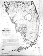
Drainage
A national push for expansion and progress in the United States occurred in the later part of the 19th century, which stimulated interest in draining the Everglades for agricultural use. According to historians, "From the middle of the nineteenth century to the middle of the twentieth century, the United States went through a period in which wetland removal was not questioned. Indeed, it was considered the proper thing to do." Draining the Everglades was suggested as early as 1837, and a resolution in Congress was passed in 1842 that prompted Secretary of Treasury Robert J. WalkerRobert J. Walker
Robert John Walker was an American economist and statesman.- Early life and education :Born in Northumberland, Pennsylvania, the son of a judge. He lived in Bellefonte, Pennsylvania from 1806 to 1814, where his father was presiding judge of the judicial district. Walker was educated at the...
to request those with experience in the Everglades to give their opinion on the possibility of drainage. Many officers who had served in the Seminole Wars favored the idea. In 1850 Congress passed a law that gave several states wetland
Wetland
A wetland is an area of land whose soil is saturated with water either permanently or seasonally. Wetlands are categorised by their characteristic vegetation, which is adapted to these unique soil conditions....
s within their state boundaries. The Swamp and Overflowed Lands Act ensured that the state would be responsible for funding the attempts at developing wetlands into farmlands. Florida quickly formed a committee to consolidate grants to pay for any attempts, though the The Civil War
American Civil War
The American Civil War was a civil war fought in the United States of America. In response to the election of Abraham Lincoln as President of the United States, 11 southern slave states declared their secession from the United States and formed the Confederate States of America ; the other 25...
and Reconstruction halted progress until after 1877.

Hamilton Disston
Hamilton Disston , was an industrialist and real-estate developer who purchased four million acres of Florida land in 1881, an area larger than the state of Connecticut, and reportedly the most land ever purchased by a single person in world history...
interested in implementing plans to drain the land for agriculture. Disston purchased 4000000 acres (16,187.4 km²) of land for $1 million in 1881, and he began constructing canals near St. Cloud
St. Cloud, Florida
St. Cloud is a city in Osceola County, Florida, United States. The population was 35,183 at the 2010 census. St. Cloud is closely associated with the adjacent city of Kissimmee and its proximity to Orlando area theme parks, including Walt Disney World, Universal Orlando Resort, and Seaworld.St...
. The canals seemed to work in lowering the water levels in the wetlands surrounding the rivers at first. They were effective in lowering the groundwater, but it became apparent that their capacity was insufficient for the wet season. Though Disston's canals did not drain well, his purchase primed the economy of Florida. It made news and attracted tourists and land buyers. Within four years property values doubled, and the population increased significantly.
The IIF was able to invest in development projects due to Disston's purchase, and an opportunity to improve transportation presented itself when oil tycoon Henry Flagler began purchasing land and building rail lines along the east coast of Florida, as far south as Palm Beach
Palm Beach, Florida
The Town of Palm Beach is an incorporated town in Palm Beach County, Florida, United States. The Intracoastal Waterway separates it from the neighboring cities of West Palm Beach and Lake Worth...
in 1893. Along the way he built resort hotels, transforming territorial outposts into tourist destinations, and the land bordering the rail lines into citrus farms. By 1896 the rail line had been extended to Biscayne Bay
Biscayne Bay
Biscayne Bay is a lagoon that is approximately 35 miles long and up to 8 miles wide located on the Atlantic coast of South Florida, United States. It is usually divided for purposes of discussion and analysis into three parts: North Bay, Central Bay, and South Bay. Its area is...
. Three months after the first train had arrived, the residents of Miami voted to incorporate the town. Miami became a prime destination for extremely wealthy people after the Royal Palm Hotel
Royal Palm Hotel (Miami)
The Royal Palm Hotel was a large resort hotel built by well-known railroad magnate Henry Flagler in Miami, Florida. Opening its doors in 1897, the Royal Palm Hotel was one of the first area hotels in Miami. Five stories tall with a sixth-floor salon, the Royal Palm Hotel featured the city's first...
was opened.
During the 1904 gubernatorial race, the strongest candidate, Napoleon Bonaparte Broward, based a significant portion of his campaign on draining the Everglades. He called the future of South Florida the "Empire of the Everglades". Soon after his successful election, he fulfilled his promise to "drain that abominable pestilence-ridden swamp", and pushed the Florida legislature to form a group of commissioners to oversee reclamation of flooded lands. In 1907 they established the Everglades Drainage District and began to study how to build the most effective canals, and how to fund them. Governor Broward ran for the U.S. Senate in 1908 but lost. Broward was paid by land developer Richard J. Bolles to tour the state to promote drainage. He was elected to the Senate in 1910, but died before he could take office. Land in the Everglades was being sold for $15 an acre a month after Broward died. Meanwhile, Henry Flagler continued to build railway stations at towns as soon as the populations warranted them.
Growth of urban areas

The increasing population in towns near the Everglades provided hunting opportunities. Raccoons and otters were the most widely hunted for their skins. Hunting often went unchecked; in one trip, a Lake Okeechobee hunter killed 250 alligators and 172 otters. Wading birds were a particular target. Their feathers were used in women's hats in the late 19th century up to the 1920s. In 1886, 5 million birds were estimated to be killed for their feathers. They were shot usually in the spring, when their feathers were colored for mating and nesting. The plumes, or aigrette
Aigrette
The term aigrette refers to the tufted crest or head-plumes of the egret, used for adorning a woman's headdress. The word may also identify any similar ornament, in gems. Aigrettes, studded with diamonds and rubies, decorated the turbans of Ottoman sultans or the ceremonial chamfron of their horses...
s, as they were called in the millinery business, sold for $32 an ounce in 1915—also the price of gold. Millinery was a $17 million a year industry that motivated plume harvesters to lay in watch of nests of egret
Egret
An egret is any of several herons, most of which are white or buff, and several of which develop fine plumes during the breeding season. Many egrets are members of the genera Egretta or Ardea which contain other species named as herons rather than egrets...
s and many colored birds during the nesting season, shoot the parents with small-bore rifles, and leave the chicks to starve. Plumes from Everglades wading birds could be found in Havana, New York City, London, and Paris. Hunters could collect plumes from a hundred birds on a good day.
Rum-runners used the Everglades as a hiding spot during Prohibition
Prohibition in the United States
Prohibition in the United States was a national ban on the sale, manufacture, and transportation of alcohol, in place from 1920 to 1933. The ban was mandated by the Eighteenth Amendment to the Constitution, and the Volstead Act set down the rules for enforcing the ban, as well as defining which...
; it was so vast there were never enough law enforcement officers to patrol it. The arrival of the railroad, and the discovery that adding trace elements like copper
Copper
Copper is a chemical element with the symbol Cu and atomic number 29. It is a ductile metal with very high thermal and electrical conductivity. Pure copper is soft and malleable; an exposed surface has a reddish-orange tarnish...
was the remedy for crops sprouting and dying quickly, soon created a population boom and new towns like Moore Haven
Moore Haven, Florida
Moore Haven is a city in Glades County, Florida, United States. The population was 1,635 at the 2000 census. As of 2004, the population recorded by the U.S. Census Bureau is 1,726. It is the county seat of Glades County...
, Clewiston
Clewiston, Florida
Clewiston is a city in Hendry County, Florida. The population was 6,460 at the 2000 census. According to the U.S Census estimates of 2005, the city had a population of 7,173. Clewiston is home to the Ah-Tah-Thi-Ki Museum and the Clewiston Museum.-History:...
, and Belle Glade
Belle Glade, Florida
Belle Glade is a city in Palm Beach County, Florida on the southeastern shore of Lake Okeechobee. The population was 14,906 at the 2000 census. According to the U.S Census estimates of 2007, the city had a population of 16,739....
. Sugarcane
Sugarcane
Sugarcane refers to any of six to 37 species of tall perennial grasses of the genus Saccharum . Native to the warm temperate to tropical regions of South Asia, they have stout, jointed, fibrous stalks that are rich in sugar, and measure two to six metres tall...
became the primary crop grown in South Florida. Miami experienced a second real estate boom that earned a developer in Coral Gables $150 million, and saw undeveloped land north of Miami sell for $30,600 an acre. In 1925, Miami newspapers published editions weighing over 7 pounds (3.2 kg), most of it in real estate advertising. Waterfront property was the most highly valued. Mangrove trees were cut down and replaced with palm trees to improve the view. Acres of South Florida slash pine
Slash Pine
Pinus elliottii, commonly known as the Slash Pine, is a pine native to the southeastern United States, from southern South Carolina west to southeastern Louisiana, and south to the Florida Keys....
were cleared. Some of the pine was for lumber, but most of the pine forests in Dade County were cleared for development.
Flood control
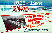
1926 Miami Hurricane
The 1926 Miami hurricane was a Category 4 hurricane that devastated Miami in September 1926. The storm also caused significant damage in the Florida Panhandle, the U.S. state of Alabama, and the Bahamas...
and 1928
1928 Okeechobee Hurricane
The Okeechobee hurricane, or San Felipe Segundo hurricane, was a deadly hurricane that struck the Leeward Islands, Puerto Rico, the Bahamas, and Florida in September of the 1928 Atlantic hurricane season...
caused Lake Okeechobee to breach its levees, killing thousands of people. The government began to focus on the control of floods rather than drainage. The Okeechobee Flood Control District was created in 1929, financed by both state and federal funds. President Herbert Hoover
Herbert Hoover
Herbert Clark Hoover was the 31st President of the United States . Hoover was originally a professional mining engineer and author. As the United States Secretary of Commerce in the 1920s under Presidents Warren Harding and Calvin Coolidge, he promoted partnerships between government and business...
toured the towns affected by the 1928 Okeechobee Hurricane and ordered the Army Corps of Engineers to assist the communities surrounding the lake. Between 1930 and 1937 a dike 66 miles (106.2 km) long was built around the southern edge of the lake. Control of the Hoover Dike and the waters of Lake Okeechobee
Lake Okeechobee
Lake Okeechobee , locally referred to as The Lake or The Big O, is the largest freshwater lake in the state of Florida. It is the seventh largest freshwater lake in the United States and the second largest freshwater lake contained entirely within the lower 48 states...
were delegated to federal powers: the United States declared legal limits of the lake to between 14 and 17 ft (4.3 and 5.2 m). A massive canal was also constructed 80 feet (24.4 m) wide and 6 feet (1.8 m) deep through the Caloosahatchee River
Caloosahatchee River
The Caloosahatchee River is a river on the southwest Gulf Coast of Florida in the United States, approximately long. It drains rural areas on the northern edge of the Everglades northwest of Miami...
; whenever the lake rose too high, the excess water left through the canal. More than $20 million was spent on the entire project. Sugarcane production soared after the dike and canal were built. The populations of the small towns surrounding the lake jumped from 3,000 to 9,000 after World War II
World War II
World War II, or the Second World War , was a global conflict lasting from 1939 to 1945, involving most of the world's nations—including all of the great powers—eventually forming two opposing military alliances: the Allies and the Axis...
.
Immediately the effects of the Hoover Dike were seen. An extended drought occurred in the 1930s; with the wall preventing water from leaving Lake Okeechobee and canals and ditches removing other water, the Everglades became parched. Peat turned to dust. Salt ocean water intruded into Miami's wells; when the city brought in an expert to explain why, he discovered that the water in the Everglades was the area's groundwater
Groundwater
Groundwater is water located beneath the ground surface in soil pore spaces and in the fractures of rock formations. A unit of rock or an unconsolidated deposit is called an aquifer when it can yield a usable quantity of water. The depth at which soil pore spaces or fractures and voids in rock...
—here, it appeared on the surface. In 1939, a million acres (4,000 km²) of Everglades burned, and the black clouds of peat and sawgrass fires hung over Miami. Scientists who took soil samples before draining did not take into account that the organic composition of peat and muck in the Everglades make it prone to soil subsidence
Subsidence
Subsidence is the motion of a surface as it shifts downward relative to a datum such as sea-level. The opposite of subsidence is uplift, which results in an increase in elevation...
when it becomes dry. Naturally occurring bacteria in Everglades peat and muck assist with the process of decomposition under water, which is generally very slow, partially due to the low levels of dissolved oxygen. When water levels became so low that peat and muck were at the surface, the bacteria interacted with much higher levels of oxygen in the air, rapidly breaking down the soil. In some places, homes had to be moved to stilts and 8 feet (2.4 m) of soil was lost.
Everglades National Park

Ernest F. Coe
Ernest "Tom" Coe was an American landscape designer who envisioned a national park dedicated to the preservation of the Everglades, culminating in the establishment of Everglades National Park. Coe was born and spent most of his life in Connecticut as a professional gardener, moving to Miami at...
established the Everglades Tropical National Park Association. It had enough support to be declared a national park by Congress in 1934. It took another 13 years to be dedicated on December 6, 1947. One month before the dedication of the park, a former editor from The Miami Herald
The Miami Herald
The Miami Herald is a daily newspaper owned by The McClatchy Company headquartered on Biscayne Bay in the Omni district of Downtown Miami, Florida, United States...
and freelance writer named Marjory Stoneman Douglas
Marjory Stoneman Douglas
Marjory Stoneman Douglas was an American journalist, writer, feminist, and environmentalist known for her staunch defense of the Everglades against efforts to drain it and reclaim land for development...
released her first book titled The Everglades: River of Grass
The Everglades: River of Grass
The Everglades: River of Grass is a non-fiction book written by Marjory Stoneman Douglas in 1947. Published the same year as the formal opening of Everglades National Park, the book was a call to attention about the degrading quality of life in the Everglades and continues to remain an influential...
. After researching the region for five years, she described the history and ecology of the South Florida in great detail. She characterized the Everglades as a river instead of a stagnant swamp. The last chapter was titled, "The Eleventh Hour" and warned that the Everglades were dying, although it could be reversed.
Central and Southern Florida Flood Control Project
The same year the park was dedicated, two hurricanes and the wet season caused 100 inches (254 cm) to fall on South Florida. Though there were no human casualties, agricultural interests lost approximately $59 million. In 1948 Congress approved the Central and Southern Florida Project for Flood Control and Other Purposes (C&SF), who divided the Everglades into basins. In the northern Everglades were Water Conservation Areas (WCAs), and the Everglades Agricultural Area (EAA) bordering to the south of Lake Okeechobee. In the southern Everglades was Everglades National Park. Levees and pumping stations bordered each WCA, and released water in dryer times or removed it and pumped it to the ocean in times of flood. The WCAs took up approximately 37 percent of the original Everglades. The C&SF constructed over 1000 miles (1,609.3 km) of canals, and hundreds of pumping stations and levees within three decades. During the 1950s and 1960s the South Florida metropolitan areaSouth Florida metropolitan area
The South Florida metropolitan area, also known as the Miami metropolitan area, and designated the Miami–Fort Lauderdale–Pompano Beach, FL Metropolitan Statistical Area by the U.S...
grew four times as fast as the rest of the nation. Between 1940 and 1965, 6 million people moved to South Florida: 1,000 people moved to Miami every week. Developed areas between the mid 1950s and the late 1960s quadrupled. Much of the water reclaimed from the Everglades was sent to newly developed areas.
Everglades Agricultural Area
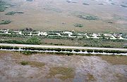
Sod
Sod or turf is grass and the part of the soil beneath it held together by the roots, or a piece of thin material.The term sod may be used to mean turf grown and cut specifically for the establishment of lawns...
, beans, lettuce, celery, and rice are also grown. Fields in the EAA are typically 40 acres (161,874.4 m²), bordered by canals on two sides, that are connected to larger canals where water is pumped in or out depending on the needs of the crops. The fertilizers used on vegetables, along with high concentrations of nitrogen
Nitrogen
Nitrogen is a chemical element that has the symbol N, atomic number of 7 and atomic mass 14.00674 u. Elemental nitrogen is a colorless, odorless, tasteless, and mostly inert diatomic gas at standard conditions, constituting 78.08% by volume of Earth's atmosphere...
and phosphorus
Phosphorus
Phosphorus is the chemical element that has the symbol P and atomic number 15. A multivalent nonmetal of the nitrogen group, phosphorus as a mineral is almost always present in its maximally oxidized state, as inorganic phosphate rocks...
that are the byproduct of decayed soil necessary for sugarcane production, were pumped into WCAs south of the EAA. The introduction of large amounts of these chemicals provided opportunities for exotic plants to take hold in the Everglades. One of the defining characteristics of natural Everglades ecology is its ability to support itself in a nutrient-poor environment, and the introduction of fertilizers began to alter the plant life in the region.
Jetport proposition
A turning point came for development in the Everglades at the proposition of an expanded airport after Miami International AirportMiami International Airport
Miami International Airport , also known as MIA and historically Wilcox Field, is the primary airport serving the South Florida area...
outgrew its capacities. The new jetport was planned to be larger than O'Hare
O'Hare International Airport
Chicago O'Hare International Airport , also known as O'Hare Airport, O'Hare Field, Chicago Airport, Chicago International Airport, or simply O'Hare, is a major airport located in the northwestern-most corner of Chicago, Illinois, United States, northwest of the Chicago Loop...
, Dulles, JFK
John F. Kennedy International Airport
John F. Kennedy International Airport is an international airport located in the borough of Queens in New York City, about southeast of Lower Manhattan. It is the busiest international air passenger gateway to the United States, handling more international traffic than any other airport in North...
, and LAX
Los Angeles International Airport
Los Angeles International Airport is the primary airport serving the Greater Los Angeles Area, the second-most populated metropolitan area in the United States. It is most often referred to by its IATA airport code LAX, with the letters pronounced individually...
airports combined, and the chosen location was 6 miles (9.7 km) north of Everglades National Park. The first sentence of the U.S. Department of Interior study of the environmental impact of the jetport
Environmental Impact of the Big Cypress Swamp Jetport
The "Environmental Impact of the Big Cypress Swamp Jetport", unofficially known as the "Leopold Report" or the "Leopold-Marshall Report", was a report authored by hydrologist Luna Leopold of the United States Geological Service for the Department of the Interior and officially released on September...
read, "Development of the proposed jetport and its attendant facilities ... will inexorably destroy the south Florida ecosystem and thus the Everglades National Park". When studies indicated the proposed jetport would create 4000000 gallons (15,141,648 l) of raw sewage a day and 10000 short tons (9,071.8 MT) of jet engine pollutants a year, the project met staunch opposition. The New York Times called it a "blueprint for disaster", and Wisconsin
Wisconsin
Wisconsin is a U.S. state located in the north-central United States and is part of the Midwest. It is bordered by Minnesota to the west, Iowa to the southwest, Illinois to the south, Lake Michigan to the east, Michigan to the northeast, and Lake Superior to the north. Wisconsin's capital is...
senator Gaylord Nelson
Gaylord Nelson
Gaylord Anton Nelson was an American politician from Wisconsin who served as a United States Senator and governor. A Democrat, he was the principal founder of Earth Day.-Public service and leadership:...
wrote to President Richard Nixon
Richard Nixon
Richard Milhous Nixon was the 37th President of the United States, serving from 1969 to 1974. The only president to resign the office, Nixon had previously served as a US representative and senator from California and as the 36th Vice President of the United States from 1953 to 1961 under...
voicing his opposition: "It is a test of whether or not we are really committed in this country to protecting our environment." Governor Claude Kirk withdrew his support for the project, and Marjory Stoneman Douglas was persuaded at 79 years old to go on tour to give hundreds of speeches against it. Nixon instead established Big Cypress National Preserve
Big Cypress National Preserve
Big Cypress National Preserve is a United States National Preserve located in southern Florida, about 45 miles west of Miami. The Big Cypress, along with Big Thicket National Preserve in Texas, became the first national preserves in the United States National Park System when they were...
, announcing it in the Special Message to the Congress Outlining the 1972 Environmental Program .
Kissimmee River
The Central and Southern Florida Flood Control Project's final construction project was straightening the Kissimmee RiverKissimmee River
The Kissimmee River is a river in south-central Florida, United States.-Course:The Kissimmee River arises in Osceola County as the outflow from East Lake Tohopekaliga, passing through Lake Tohopekaliga, Lake Cypress, Lake Hatchineha and Lake Kissimmee...
, a meandering 90 miles (144.8 km)-long river that was drained to make way for grazing land and agriculture. The C&SF started building the C-38 canal in 1962 and the effects were seen almost immediately. Waterfowl, wading birds, and fish disappeared, prompting conservationists and sport fishers to demand the region be restored before the canal was finished in 1971. In general, C&SF projects had been criticized for being temporary fixes that ignored future consequences, costing billions of dollars with no end in sight. After Governor Bob Graham
Bob Graham
Daniel Robert "Bob" Graham is an American politician. He was the 38th Governor of Florida from 1979 to 1987 and a United States Senator from that state from 1987 to 2005...
initiated the Save Our Everglades campaign in 1983, the first section of the canal was backfilled in 1986. Graham announced that by 2000 the Everglades would be restored as closely as possible to its pre-drainage state. The Kissimmee River Restoration project was approved by Congress in 1992. It is estimated that it will cost $578 million to convert only 22 miles (35.4 km) of the canal. The entire project will be complete by 2011.
Water quality
Further problems with the environment arose when a vast algal bloomAlgal bloom
An algal bloom is a rapid increase or accumulation in the population of algae in an aquatic system. Algal blooms may occur in freshwater as well as marine environments. Typically, only one or a small number of phytoplankton species are involved, and some blooms may be recognized by discoloration...
appeared in one-fifth of Lake Okeechobee in 1986. The same year cattails
Typha
Typha is a genus of about eleven species of monocotyledonous flowering plants in the family Typhaceae. The genus has a largely Northern Hemisphere distribution, but is essentially cosmopolitan, being found in a variety of wetland habitats...
were discovered overtaking sawgrass marshes in Loxahatchee National Wildlife Refuge
Loxahatchee National Wildlife Refuge
The 147,392 acre Arthur R. Marshall Loxahatchee National Wildlife Refuge includes the most northern remnant of the historic Everglades wetland ecosystem...
. Scientists discovered that phosphorus
Phosphorus
Phosphorus is the chemical element that has the symbol P and atomic number 15. A multivalent nonmetal of the nitrogen group, phosphorus as a mineral is almost always present in its maximally oxidized state, as inorganic phosphate rocks...
, used as a fertilizer in the EAA, was flushed into canals and pumped back into the lake. When the lake drained, the phosphorus entered the water in the marshes, changing the nutrient levels. It kept periphyton from forming marl, one of two soils in the Everglades. The arrival of phosphorus allowed cattails to spread quickly. The cattails grew in dense mats—too thick for birds or alligators to nest in. It also dissolved oxygen in the peat, promoted algae, and prohibited growth of native invertebrates on the bottom of the food chain.
At the same time mercury
Mercury (element)
Mercury is a chemical element with the symbol Hg and atomic number 80. It is also known as quicksilver or hydrargyrum...
was found in local fish at such high levels that consumption warnings were posted for fishermen. A Florida panther was found dead with levels of mercury high enough to kill a human. Scientists found that power plants and incinerators using fossil fuels were expelling mercury into the atmosphere, and it fell as rain or dust during droughts. The naturally occurring bacteria that reduce sulfur in the Everglades ecosystem were transforming the mercury into methylmercury
Methylmercury
Methylmercury is an organometallic cation with the formula . It is a bioaccumulative environmental toxicant.-Structure:...
, and it was bioaccumulating
Bioaccumulation
Bioaccumulation refers to the accumulation of substances, such as pesticides, or other organic chemicals in an organism. Bioaccumulation occurs when an organism absorbs a toxic substance at a rate greater than that at which the substance is lost...
through the food chain. Stricter emissions standards helped lower mercury coming from power plants and incinerators, which in turn lowered mercury levels found in animals, though they continue to be a concern.
The Everglades Forever Act, introduced by Governor Lawton Chiles
Lawton Chiles
Lawton Mainor Chiles, Jr. was an American politician from the US state of Florida. In a career spanning four decades, Chiles, a Democrat who never lost an election, served in the Florida House of Representatives , the Florida State Senate , the United States Senate , and as the 41st Governor of...
in 1994, was an attempt to legislate the lowering of phosphorus in Everglades waterways. The act put the South Florida Water Management District
South Florida Water Management District
The South Florida Water Management District is a regional governmental agency supervised by the Florida Department of Environmental Protection , and is responsible for water quality, flood control, water supply and restoration of the environment in 16 counties in Central and Southern Florida...
(SFWMD) and the Florida Department of Environmental Protection
Florida Department of Environmental Protection
The Florida Department of Environmental Protection is the Florida government agency charged with environmental protection.-History:...
(DEP) in charge of testing and enforcing low phosphorus levels: 10 parts per billion (ppb) (down from 500 ppb in the 1980s). The SFWMD built Stormwater Treatment Areas (STAs) near sugarcane fields where water leaving the EAA flows into ponds lined with lime rock and layers of peat and calcareous
Calcareous
Calcareous is an adjective meaning mostly or partly composed of calcium carbonate, in other words, containing lime or being chalky. The term is used in a wide variety of scientific disciplines.-In zoology:...
periphyton. Testing has shown this method to be more effective than previously anticipated, bringing levels from 80 ppb to 10 ppb.
Invasive species
The Everglades also face an ongoing threat from the melaleuca tree (Melaleuca quinquenerviaMelaleuca quinquenervia
Melaleuca quinquenervia, commonly known as Niaouli or Broad-leaved paperbark or the Paper Bark Tea Tree, is a small- to medium-sized tree of the allspice family, Myrtaceae. The plant is native to New Caledonia, Papua New Guinea and coastal Eastern Australia, from Botany Bay in New South Wales...
), because they take water in greater amounts than other trees. Melaleucas grow taller and more densely in the Everglades than in their native Australia, making them unsuitable as nesting areas for birds with wide wingspans. They also choke out native vegetation. More than $2 million has been spent on keeping them out of Everglades National Park.
Brazilian pepper, or Florida holly (Schinus terebinthifolius), has also wreaked havoc on the Everglades, exhibiting a tendency to spread rapidly and to crowd out native species of plants as well as to create inhospitable environments for native animals. It is especially difficult to eradicate and is readily propagated by birds, which eat its small red berries. The Brazilian Pepper problem is not exclusive to the Everglades; neither is the water hyacinth
Water hyacinth
The seven species of water hyacinth comprise the genus Eichhornia. Water hyacinth are a free-floating perennial aquatic plant native to tropical and sub-tropical South America. With broad, thick, glossy, ovate leaves, water hyacinth may rise above the surface of the water as much as 1 meter in...
, which is a widespread problem in Florida's waterways, a major threat to endemic species, and is difficult and costly to eradicate. The Old World climbing fern (Lygodium microphyllum
Lygodium microphyllum
Lygodium microphyllum is a climbing fern originating in tropical Africa, South East Asia, Melanesia and Australia. It is an invasive weed in the US States of Florida and Alabama where it invades open forest and wetland areas...
) may be causing the most harm to restoration as it blankets areas thickly, making it impossible for animals to pass through. It also climbs up trees and creates "fire ladders", allowing parts of the trees to burn that would otherwise remain unharmed.
Many pets have escaped or been released into the Everglades from the surrounding urban areas. Some find the conditions quite favorable and have established self-sustaining populations, competing for food and space with native animals. Many tropical fish have been released, but blue tilapias (Oreochromis aureus
Oreochromis aureus
Oreochromis aureus is a species of fish in the Cichlidae family. Native to Northern and Western Africa, and the Middle East, through introductions it is now also established elsewhere, including parts of the United States, where it has been declared an invasive species and has caused significant...
) cause damage to shallow waterways by creating large nests and consuming aquatic plants that protect native young fish.
Native to southern Asia, the Burmese python (Python molurus bivittatus) is a relatively new invasive species in the Everglades. The species can grow up to 20 feet (6.1 m) long and they compete with alligators for the top of the food chain. Florida wildlife officials speculate that escaped pythons
Burmese Pythons in Florida
The Burmese python, a large, non-venomous constrictor native to Southeast Asia, has been sighted and captured with increasing frequency in the Everglades and is generally labeled an invasive species...
have begun reproducing in an environment for which they are well-suited. In Everglades National Park alone, agents removed more than 1,200 Burmese python from the park as of 2009.
The invasive species that causes the most damage is the cat, both domestic and feral
Feral
A feral organism is one that has changed from being domesticated to being wild or untamed. In the case of plants it is a movement from cultivated to uncultivated or controlled to volunteer. The introduction of feral animals or plants to their non-native regions, like any introduced species, may...
. Cats that are let outside live close to suburban populations and have been estimated to number 640 per square mile. In such close numbers in historic migratory areas, they have devastating effects on migratory bird populations.
Comprehensive Everglades Restoration Plan
Though scientists made headway in decreasing mercury and phosphorus levels in water, the natural environment of South Florida continued to decline in the 1990s, and life in nearby cities reflected this downturn. To address the deterioration of the South Florida metropolitan areaSouth Florida metropolitan area
The South Florida metropolitan area, also known as the Miami metropolitan area, and designated the Miami–Fort Lauderdale–Pompano Beach, FL Metropolitan Statistical Area by the U.S...
, Governor Lawton Chiles commissioned a report on the sustainability
Sustainability
Sustainability is the capacity to endure. For humans, sustainability is the long-term maintenance of well being, which has environmental, economic, and social dimensions, and encompasses the concept of union, an interdependent relationship and mutual responsible position with all living and non...
of the area. In 1995, Chiles published the commission's findings in a report that related the degradation of the Everglades ecosystems to the lower quality of life in urban areas. The report noted past environmental abuses that brought the state to a position to make a decision. Not acting to improve the South Florida ecosystem, the report predicted, would inevitably cause further and intolerable deterioration that would harm local tourism by 12,000 jobs and $200 million annually, and commercial fishing by 3,300 jobs and $52 million annually. Urban areas had grown beyond their capacities to sustain themselves. Crowded cities were facing problems such as high crime rates, traffic jams, severely overcrowded schools, and overtaxed public services; the report noted that water shortages were ironic, given the 53 inches (134.6 cm) of rain the region received annually.
In 1999, an evaluation of the C&SF was submitted to Congress as part of the Water Development Act of 1992. The seven-year report, called the "Restudy", cited indicators of harm to the ecosystem: a 50 percent reduction in the original Everglades, diminished water storage, harmful timing of water releases from canals and pumping stations, an 85 to 90 percent decrease in wading bird populations over the past 50 years, and the decline of output from commercial fisheries. Bodies of water including Lake Okeechobee
Lake Okeechobee
Lake Okeechobee , locally referred to as The Lake or The Big O, is the largest freshwater lake in the state of Florida. It is the seventh largest freshwater lake in the United States and the second largest freshwater lake contained entirely within the lower 48 states...
, the Caloosahatchee River
Caloosahatchee River
The Caloosahatchee River is a river on the southwest Gulf Coast of Florida in the United States, approximately long. It drains rural areas on the northern edge of the Everglades northwest of Miami...
, St. Lucie
St. Lucie River
The St. Lucie River is a estuary in St. Lucie and Martin counties in the U.S. state of Florida. Its North Fork flows south from St Lucie County into Martin County where it joins the north-flowing South Fork, which was once called the Halpatiokee River, just south of the old Roosevelt Bridge in...
estuary, Lake Worth Lagoon
Lake Worth Lagoon
The Lake Worth Lagoon is a lagoon located in Palm Beach County, Florida. It runs parallel to the coast, and is separated from the Atlantic Ocean by barrier beaches, including Palm Beach Island. The lagoon is connected to the Atlantic Ocean by two permanent, man-made inlets.-Geography:Lake Worth...
, Biscayne Bay
Biscayne Bay
Biscayne Bay is a lagoon that is approximately 35 miles long and up to 8 miles wide located on the Atlantic coast of South Florida, United States. It is usually divided for purposes of discussion and analysis into three parts: North Bay, Central Bay, and South Bay. Its area is...
, Florida Bay
Florida Bay
Florida Bay is the bay located between the southern end of the Florida mainland and the Florida Keys. Its area is variously stated to be , or , or . Nearly all of Florida Bay is included in Everglades National Park. The southern edge, along the Florida Keys is in the Florida Keys National Marine...
and the Everglades reflected drastic water level changes, hypersalinity
Salinity
Salinity is the saltiness or dissolved salt content of a body of water. It is a general term used to describe the levels of different salts such as sodium chloride, magnesium and calcium sulfates, and bicarbonates...
, and dramatic changes in marine and freshwater ecosystems. The Restudy noted the overall decline in water quality over the past 50 years was due to loss of wetlands that act as filters for polluted water. It predicted that without intervention the entire South Florida ecosystem would deteriorate. Water shortages would become common and some cities would have annual water restrictions.

Comprehensive Everglades Restoration Plan
The Central and Southern Florida Project, which was first authorized by Congress in 1948, is a multi-purpose project that provides flood control, water supply for municipal, industrial, and agricultural uses, prevention of saltwater intrusion, water supply for Everglades National Park, and...
(CERP) proposed more than 60 construction projects over 30 years to store water that was being flushed into the ocean, in reservoirs, underground aquifers, and abandoned quarries; add more Stormwater Treatment Areas to filter water that flowed into the lower Everglades; regulate water released from pumping stations into local waterways and improve water released to Everglades National Park and Water Conservation Areas; remove barriers to sheetflow by raising the Tamiami Trail
Tamiami Trail
The Tamiami Trail is the southernmost of U.S. Highway 41 from State Road 60 in Tampa to U.S. Route 1 in Miami. The road also has the hidden designation of State Road 90....
and destroying the Miami Canal, and reuse wastewater for urban areas. The cost estimate for the entire plan was $7.8 billion, and in a bipartisan show of cooperation, CERP was voted through Congress with an overwhelming margin. It was signed by President Bill Clinton
Bill Clinton
William Jefferson "Bill" Clinton is an American politician who served as the 42nd President of the United States from 1993 to 2001. Inaugurated at age 46, he was the third-youngest president. He took office at the end of the Cold War, and was the first president of the baby boomer generation...
on December 11, 2000.
Since its signing, the State of Florida reports that it has spent more than $2 billion on the various projects. More than 36000 acres (145.7 km²) of Stormwater Treatment Areas have been constructed to filter 2500 short tons (2,268 MT) of phosphorus from Everglades waters. An STA spanning 17000 acres (68.8 km²) was constructed in 2004, making it the largest manmade wetland in the world. Fifty-five percent of the land necessary to acquire for restoration has been purchased by the State of Florida, totaling 210167 acres (850.5 km²). A plan to hasten the construction and funding of projects was put into place, named "Acceler8", spurring the start of six of eight large construction projects, including that of three large reservoirs. However, federal funds have not been forthcoming; CERP was signed when the U.S. government had a budget surplus, but since then the War in Iraq began, and two of CERP's major supporters in Congress retired. According to a story in The New York Times
The New York Times
The New York Times is an American daily newspaper founded and continuously published in New York City since 1851. The New York Times has won 106 Pulitzer Prizes, the most of any news organization...
, state officials say the restoration is lost in a maze of "federal bureaucracy, a victim of 'analysis paralysis'". CERP still remains controversial as the projects slated for Acceler8, environmental activists note, are those that benefit urban areas, and regions in the Everglades in desperate need of water are still being neglected, suggesting that water is being diverted to make room for more people in an already overtaxed environment.
Future of the Everglades
In 2008, the State of Florida agreed to buy U.S. SugarUS Sugar Corporation
U.S. Sugar Corporation is a large privately owned agricultural business based in Clewiston, Florida.. The company farms over of land in the counties of Hendry, Glades and Palm Beach. It is the largest producer of sugarcane in the United States, producing over 700,000 tons per year...
and all of its manufacturing and production facilities for an estimated $1.7 billion. Florida officials indicated they intended to allow U.S. Sugar to process for six more years before dismissing its employees and dismantling the plant. The area, which includes 187000 acres (756.8 km²) of land, would then be rehabilitated and water flow from Lake Okeechobee would be restored. In November 2008, the agreement was revised to offer $1.34 billion, allowing sugar mills in Clewiston to remain in production. Critics of the revised plan say that it ensures sugarcane will be grown in the Everglades for at least another decade. Further research is being done to address the continuing production of sugarcane in the Everglades to minimize phosphorus runoff.
Everglades restoration received $96 million of the American Recovery and Reinvestment Act of 2009
American Recovery and Reinvestment Act of 2009
The American Recovery and Reinvestment Act of 2009, abbreviated ARRA and commonly referred to as the Stimulus or The Recovery Act, is an economic stimulus package enacted by the 111th United States Congress in February 2009 and signed into law on February 17, 2009, by President Barack Obama.To...
. As a result of the stimulus package, a mile-long (1.6 km) bridge to replace the Tamiami Trail
Tamiami Trail
The Tamiami Trail is the southernmost of U.S. Highway 41 from State Road 60 in Tampa to U.S. Route 1 in Miami. The road also has the hidden designation of State Road 90....
, a road that borders Everglades National Park to the north and has blocked water from reaching the southern Everglades, was begun by the Army Corps of Engineers in December 2009. The next month work began to reconstruct the C-111 canal, east of the park that historically diverted water into Florida Bay. Governor Charlie Crist
Charlie Crist
Charles Joseph "Charlie" Crist, Jr. is an American politician who was the 44th Governor of Florida. Prior to his election as governor, Crist previously served as Florida State Senator, Education Commissioner, and Attorney General...
announced the same month that $50 million of state funds would be earmarked for Everglades restoration. In May 2010, 5.5 miles (8.9 km) of bridges were proposed to be added to the Tamiami Trail.
See also
- History of FloridaHistory of FloridaThe history of Florida can be traced back to when the first Native Americans began to inhabit the peninsula as early as 14,000 years ago. Recorded history begins with the arrival of Europeans to Florida, beginning with the Spanish explorer Juan Ponce de León, who explored the area in 1513...
- Everglades PseudoatollEverglades PseudoatollThe Everglades Pseudoatoll was a major geomorphic feature of southern Florida during the Pliocene epoch.-Origin:The Everglades Pseudoatoll began its growth during the early Eocene as a paleodepression possibly created by an asteroid impact upon the carbonate Florida Platform at the southern part...
- Everglades FoundationEverglades Foundation-History:The Everglades Foundation was formed by a group of outdoor enthusiasts, environmentalists and residents of Florida who were concerned over the decline of the Everglades and the resulting damage in the nearby natural and protected areas such as Florida Bay...
External links
Geography and ecology- Everglades National Park and Big Cypress National Preserve
- Arthur R. Marshall National Wildlife Refuge (US Fish & Wildlife Service)
- Everglades Cooperative Invasive Species Management Area
History
- A History of the Everglades
- World Wide Fund for Nature – A Recent History of Everglades Regulation and Litigation
Restoration
- The Comprehensive Everglades Restoration Plan (CERP)
- The Everglades Foundation
- The Everglades Coalition
- South Florida Information Access (U.S. Geological Survey)
- Environment Florida – Founders of The "Save The Everglades" campaign
- ACCELER8 (Everglades Restoration)
- Friends of the Everglades
- South Florida Environmental Report (South Florida Water Management District and Florida DEP)
Media
- Everglades Digital Library
- Water's Journey: Everglades – Comprehensive film and web documentary about the Everglades
- The Everglades in the Time of Marjorie Stoneman Douglas (Photo exhibit)
- Everglades images at bioimages.vanderbilt.edu (Slow modem version)
- The Everglades in Peril - slideshow by The New York TimesThe New York TimesThe New York Times is an American daily newspaper founded and continuously published in New York City since 1851. The New York Times has won 106 Pulitzer Prizes, the most of any news organization...