
Pope County, Arkansas
Encyclopedia
Pope County is a county
located in the U.S. state
of Arkansas
. As of 2010, the population was 61,754. The county seat
is Russellville
. The county was formed on November 2, 1829, from a portion of Crawford County and named for John Pope
, the third governor of the Arkansas Territory
. It is an alcohol prohibition or dry county
.
Pope County is part of the Russellville Micropolitan Statistical Area
.
 As of the census
of 2000, there were 54,469 people, 20,701 households, and 15,008 families residing in the county. The population density
was 67 people per square mile (26/km²). There were 22,851 housing units at an average density of 28 per square mile (11/km²). The racial makeup of the county was 93.73% White
, 2.61% Black
or African American
, 0.68% Native American
, 0.64% Asian
, 0.03% Pacific Islander
, 0.93% from other races
, and 1.39% from two or more races. 2.06% of the population were Hispanic
or Latino
of any race.
There were 20,701 households out of which 34.30% had children under the age of 18 living with them, 58.60% were married couples
living together, 10.20% had a female householder with no husband present, and 27.50% were non-families. 23.00% of all households were made up of individuals and 9.10% had someone living alone who was 65 years of age or older. The average household size was 2.55 and the average family size was 3.00.
In the county the population was spread out with 25.50% under the age of 18, 11.60% from 18 to 24, 28.20% from 25 to 44, 21.90% from 45 to 64, and 12.70% who were 65 years of age or older. The median age was 35 years. For every 100 females there were 96.40 males. For every 100 females age 18 and over, there were 94.10 males.
The median income for a household in the county was $32,069, and the median income for a family was $39,055. Males had a median income of $29,914 versus $19,307 for females. The per capita income
for the county was $15,918. About 11.60% of families and 15.20% of the population were below the poverty line, including 18.80% of those under age 18 and 14.00% of those age 65 or over.
County (United States)
In the United States, a county is a geographic subdivision of a state , usually assigned some governmental authority. The term "county" is used in 48 of the 50 states; Louisiana is divided into parishes and Alaska into boroughs. Parishes and boroughs are called "county-equivalents" by the U.S...
located in the U.S. state
U.S. state
A U.S. state is any one of the 50 federated states of the United States of America that share sovereignty with the federal government. Because of this shared sovereignty, an American is a citizen both of the federal entity and of his or her state of domicile. Four states use the official title of...
of Arkansas
Arkansas
Arkansas is a state located in the southern region of the United States. Its name is an Algonquian name of the Quapaw Indians. Arkansas shares borders with six states , and its eastern border is largely defined by the Mississippi River...
. As of 2010, the population was 61,754. The county seat
County seat
A county seat is an administrative center, or seat of government, for a county or civil parish. The term is primarily used in the United States....
is Russellville
Russellville, Arkansas
Russellville is the county seat and largest city in Pope County, Arkansas, United States, with a population of 27,920, according to the 2010 Census. It is home to Arkansas Tech University and Arkansas Nuclear One, Arkansas' only nuclear power plant...
. The county was formed on November 2, 1829, from a portion of Crawford County and named for John Pope
John Pope (politician)
John Pope was a United States Senator from Kentucky, a member of the United States House of Representatives from Kentucky, Secretary of State of Kentucky, and Governor of Arkansas Territory....
, the third governor of the Arkansas Territory
Arkansas Territory
The Territory of Arkansas, initially organized as the Territory of Arkansaw, was an organized incorporated territory of the United States that existed from July 4, 1819 until June 15, 1836, when the final extent of the territory was admitted to the Union as the State of Arkansas.-History:The...
. It is an alcohol prohibition or dry county
Dry county
A dry county is a county in the United States whose government forbids the sale of alcoholic beverages. Some prohibit off-premises sale, some prohibit on-premises sale, and some prohibit both. Hundreds of dry counties exist across the United States, almost all of them in the South...
.
Pope County is part of the Russellville Micropolitan Statistical Area
Russellville micropolitan area
The Russellville Micropolitan Statistical Area, as defined by the United States Census Bureau, is an area consisting of two counties in the U.S...
.
Geography
According to the 2000 census, the county has a total area of 830.79 square miles (2,151.7 km²), of which 811.9 square miles (2,102.8 km²) (or 97.73%) is land and 18.89 square miles (48.9 km²) (or 2.27%) is water.Major highways
.svg.png) Interstate 40Interstate 40Interstate 40 is the third-longest major east–west Interstate Highway in the United States, after I-90 and I-80. Its western end is at Interstate 15 in Barstow, California; its eastern end is at a concurrency of U.S. Route 117 and North Carolina Highway 132 in Wilmington, North Carolina...
Interstate 40Interstate 40Interstate 40 is the third-longest major east–west Interstate Highway in the United States, after I-90 and I-80. Its western end is at Interstate 15 in Barstow, California; its eastern end is at a concurrency of U.S. Route 117 and North Carolina Highway 132 in Wilmington, North Carolina... U.S. Highway 64
State highways
 Arkansas Highway 7
 Arkansas Highway 7 Spur
 Arkansas Highway 7 Truck
 Arkansas Highway 16
 Arkansas Highway 27
 Arkansas Highway 105Arkansas Highway 105Arkansas Highway 105 is a state highway of in Pope County, Arkansas.-Route description:The route begins in southern Pope County at Galla Creek Wildlife Management Area and runs north through Atkins. AR 105 meets Interstate 40 in Atkins and then continues north. The route briefly meets AR 124...
 Arkansas Highway 123Arkansas Highway 123-Boone County:Arkansas Highway 123 is a brief state highway in Boone County, Arkansas. It runs vertically from Salmon Lane north to U.S. Route 65 near Harrison.-Johnson/Pope/Newton Counties:...
 Arkansas Highway 124Arkansas Highway 124Arkansas Highway 124 is a designation for two state highways in Central Arkansas. The western segment of runs from Russellville to Rose Bud. An eastern segment of runs east in White County from Pangburn to AR 157.-Russellville to Rose Bud:...
 Arkansas Highway 164Arkansas Highway 164Arkansas Highway 164 is a state highway of that runs in Johnson and Pope Counties.-Route description:The route begins at US 64 near Coal Hill. It runs north across Interstate 40 and AR 352 before turning west. A concurrency begins with AR 103 into Clarksville. The route again meets US 64 before...
 Arkansas Highway 247Arkansas Highway 247Arkansas Highway 247 is a state highway of in Pope and Conway Counties.-Route description:The route begins at AR 7 in south Russellville. AR 247 runs east until forming a concurrency with US 64 to Atkins. The route turns north in a short concurrency with AR 105. AR 247 next enters Conway County...
 Arkansas Highway 324Arkansas Highway 324Arkansas Highway 324 is the name of two state highways in Pope County, Arkansas.-Route description:The route begins at AR 105 and loops west around Lake Atkins. AR 324 terminates at AR 105 in south Atkins.-Route description:...
 Arkansas Highway 326Arkansas Highway 326-Section 1:Arkansas Highway 326 is a state highway of in Russellville. AR 326 runs west as a beltway around the city. The route was formed between 1964-1983.-Route description:...
- Arkansas Highway 331Arkansas Highway 331Arkansas Highway 331 is a north–south state highway in Pope County, Arkansas. The route runs from Arkansas Highway 247 in Pottsville north across Interstate 40 to terminate at the northbound ramps.-Route description:...
 Arkansas Highway 333Arkansas Highway 333-Section 1:Arkansas Highway 333 is a state highway of in Searcy County.-Route description:The route begins at Searcy County Route 8 and runs north to meet AR 27. Near the Searcy County Airport, AR 333 breaks from AR 27 and runs north. The route then meets US 65/AR 74...
 Arkansas Highway 363Arkansas Highway 363Arkansas Highway 363 is the name of two state highways in Pope County.-Section 1:Arkansas Highway 363 is a state highway in Pope County near Pottsville. The route runs north from US 64/AR 247 across Interstate 40 to terminate at Phillips Road....
.svg.png) Arkansas Highway 980Arkansas Highway 980Arkansas Highway 980 is a state highway designation for all state maintained airport roads in Arkansas.-Section 1:Arkansas Highway 980 is a state highway of in Arkansas County. It connects Arkansas Highway 130 with Almyra Municipal Airport in Almyra....
Arkansas Highway 980Arkansas Highway 980Arkansas Highway 980 is a state highway designation for all state maintained airport roads in Arkansas.-Section 1:Arkansas Highway 980 is a state highway of in Arkansas County. It connects Arkansas Highway 130 with Almyra Municipal Airport in Almyra....
Adjacent counties
- Newton CountyNewton County, ArkansasNewton County is a county located in the U.S. state of Arkansas. As of 2010, the population is 8,330. The county seat is Jasper. Newton County is Arkansas's 46th county, formed on December 14, 1842, and named for Thomas W. Newton, an Arkansas Congressman...
(northwest) - Searcy County & Van Buren County (northeast)
- Conway County (southeast)
- Yell CountyYell County, ArkansasYell County is a county located in the U.S. state of Arkansas. As of 2010, the population was 22,185. The county has two county seats, Dardanelle and Danville...
(south) - Logan CountyLogan County, ArkansasLogan County is a county located in the U.S. state of Arkansas. As of 2010, the population was 22,353. There are two county seats: Booneville and Paris.-History :...
(southwest) - Johnson County (west)
National protected areas
- Holla Bend National Wildlife RefugeHolla Bend National Wildlife RefugeHolla Bend National Wildlife Refuge is a 6,486 acre wildlife refuge located 5 miles southeast from Dardanelle, Arkansas.The Holla Bend National Wildlife Refuge is bounded on one side by the Arkansas River and on its other sides by an oxbow lake that was formerly the main channel of the Arkansas...
(part) - Ozark National Forest (part)
Demographics
Census
A census is the procedure of systematically acquiring and recording information about the members of a given population. It is a regularly occurring and official count of a particular population. The term is used mostly in connection with national population and housing censuses; other common...
of 2000, there were 54,469 people, 20,701 households, and 15,008 families residing in the county. The population density
Population density
Population density is a measurement of population per unit area or unit volume. It is frequently applied to living organisms, and particularly to humans...
was 67 people per square mile (26/km²). There were 22,851 housing units at an average density of 28 per square mile (11/km²). The racial makeup of the county was 93.73% White
Race (United States Census)
Race and ethnicity in the United States Census, as defined by the Federal Office of Management and Budget and the United States Census Bureau, are self-identification data items in which residents choose the race or races with which they most closely identify, and indicate whether or not they are...
, 2.61% Black
Race (United States Census)
Race and ethnicity in the United States Census, as defined by the Federal Office of Management and Budget and the United States Census Bureau, are self-identification data items in which residents choose the race or races with which they most closely identify, and indicate whether or not they are...
or African American
Race (United States Census)
Race and ethnicity in the United States Census, as defined by the Federal Office of Management and Budget and the United States Census Bureau, are self-identification data items in which residents choose the race or races with which they most closely identify, and indicate whether or not they are...
, 0.68% Native American
Race (United States Census)
Race and ethnicity in the United States Census, as defined by the Federal Office of Management and Budget and the United States Census Bureau, are self-identification data items in which residents choose the race or races with which they most closely identify, and indicate whether or not they are...
, 0.64% Asian
Race (United States Census)
Race and ethnicity in the United States Census, as defined by the Federal Office of Management and Budget and the United States Census Bureau, are self-identification data items in which residents choose the race or races with which they most closely identify, and indicate whether or not they are...
, 0.03% Pacific Islander
Race (United States Census)
Race and ethnicity in the United States Census, as defined by the Federal Office of Management and Budget and the United States Census Bureau, are self-identification data items in which residents choose the race or races with which they most closely identify, and indicate whether or not they are...
, 0.93% from other races
Race (United States Census)
Race and ethnicity in the United States Census, as defined by the Federal Office of Management and Budget and the United States Census Bureau, are self-identification data items in which residents choose the race or races with which they most closely identify, and indicate whether or not they are...
, and 1.39% from two or more races. 2.06% of the population were Hispanic
Race (United States Census)
Race and ethnicity in the United States Census, as defined by the Federal Office of Management and Budget and the United States Census Bureau, are self-identification data items in which residents choose the race or races with which they most closely identify, and indicate whether or not they are...
or Latino
Race (United States Census)
Race and ethnicity in the United States Census, as defined by the Federal Office of Management and Budget and the United States Census Bureau, are self-identification data items in which residents choose the race or races with which they most closely identify, and indicate whether or not they are...
of any race.
There were 20,701 households out of which 34.30% had children under the age of 18 living with them, 58.60% were married couples
Marriage
Marriage is a social union or legal contract between people that creates kinship. It is an institution in which interpersonal relationships, usually intimate and sexual, are acknowledged in a variety of ways, depending on the culture or subculture in which it is found...
living together, 10.20% had a female householder with no husband present, and 27.50% were non-families. 23.00% of all households were made up of individuals and 9.10% had someone living alone who was 65 years of age or older. The average household size was 2.55 and the average family size was 3.00.
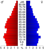
In the county the population was spread out with 25.50% under the age of 18, 11.60% from 18 to 24, 28.20% from 25 to 44, 21.90% from 45 to 64, and 12.70% who were 65 years of age or older. The median age was 35 years. For every 100 females there were 96.40 males. For every 100 females age 18 and over, there were 94.10 males.
The median income for a household in the county was $32,069, and the median income for a family was $39,055. Males had a median income of $29,914 versus $19,307 for females. The per capita income
Per capita income
Per capita income or income per person is a measure of mean income within an economic aggregate, such as a country or city. It is calculated by taking a measure of all sources of income in the aggregate and dividing it by the total population...
for the county was $15,918. About 11.60% of families and 15.20% of the population were below the poverty line, including 18.80% of those under age 18 and 14.00% of those age 65 or over.
Cities and towns
|
Hector, Arkansas Hector is a town in Pope County, Arkansas, United States. The population was 506 at the 2000 census. It is part of the Russellville Micropolitan Statistical Area.-Geography:Hector is located at .... London, Arkansas London is a city in Pope County, Arkansas, United States. The population was 925 at the 2000 census. It is part of the Russellville Micropolitan Statistical Area.-Geography:London is located at .... |
|
Townships
- Bayliss
- Burnett
- Center
- Clark (LondonLondon, ArkansasLondon is a city in Pope County, Arkansas, United States. The population was 925 at the 2000 census. It is part of the Russellville Micropolitan Statistical Area.-Geography:London is located at ....
) - Convenience
- Dover (DoverDover, ArkansasDover is a small town in Pope County, Arkansas, United States. The population was 1,329 at the 2000 census. It is part of the Russellville Micropolitan Statistical Area.- Geography :Dover is located at ....
, small part of RussellvilleRussellville, ArkansasRussellville is the county seat and largest city in Pope County, Arkansas, United States, with a population of 27,920, according to the 2010 Census. It is home to Arkansas Tech University and Arkansas Nuclear One, Arkansas' only nuclear power plant...
) - Freeman
- Galla (most of PottsvillePottsville, ArkansasPottsville is a town in Pope County, Arkansas, United States. As of the 2000 census the population was 1,271. It is part of the Russellville Micropolitan Statistical Area.-Geography:Pottsville is located at...
, small part of RussellvilleRussellville, ArkansasRussellville is the county seat and largest city in Pope County, Arkansas, United States, with a population of 27,920, according to the 2010 Census. It is home to Arkansas Tech University and Arkansas Nuclear One, Arkansas' only nuclear power plant...
) - Griffin
- Gum Log
- Illinois (most of RussellvilleRussellville, ArkansasRussellville is the county seat and largest city in Pope County, Arkansas, United States, with a population of 27,920, according to the 2010 Census. It is home to Arkansas Tech University and Arkansas Nuclear One, Arkansas' only nuclear power plant...
, small part of PottsvillePottsville, ArkansasPottsville is a town in Pope County, Arkansas, United States. As of the 2000 census the population was 1,271. It is part of the Russellville Micropolitan Statistical Area.-Geography:Pottsville is located at...
) - Jackson (HectorHector, ArkansasHector is a town in Pope County, Arkansas, United States. The population was 506 at the 2000 census. It is part of the Russellville Micropolitan Statistical Area.-Geography:Hector is located at ....
) - Liberty
- Martin
- Moreland
- Phoenix
- Smyrna
- Valley
- Wilson (AtkinsAtkins, ArkansasAtkins is a city in Pope County, Arkansas, United States. The population was 2,878 at the 2000 census. It is part of the Russellville Micropolitan Statistical Area.-Geography:Atkins is located at ....
)