

Dallas County, Alabama
Encyclopedia
Dallas County is a county
of the U.S. state
of Alabama
. Its name is in honor of United States Secretary of the Treasury
Alexander J. Dallas
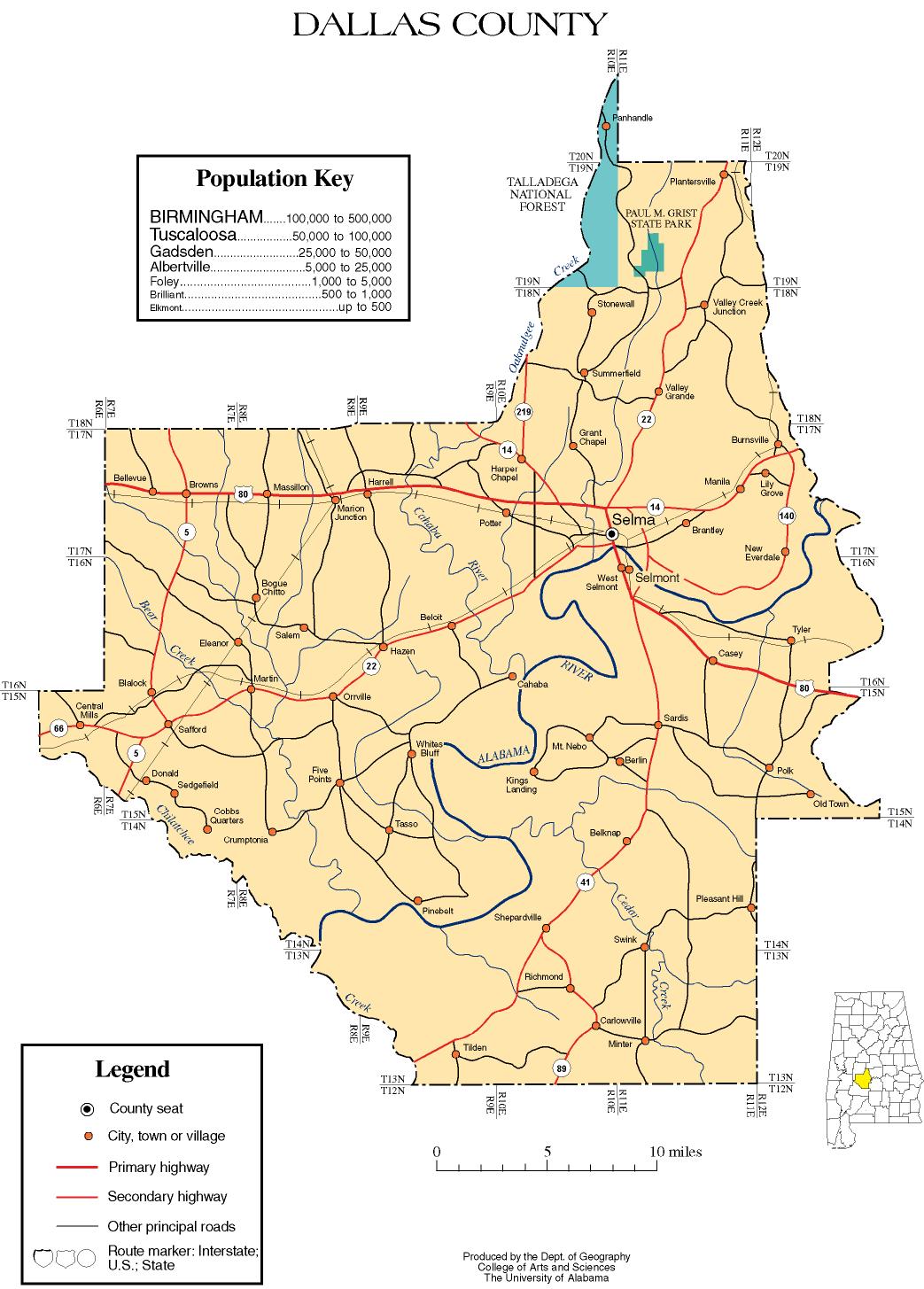
. The county seat
is Selma
.
, a portion of the Creek cession
of August 9, 1814. It was named for U.S. Treasury Secretary Alexander J. Dallas
of Pennsylvania
.
Dallas County is located in the Black Belt
region of the west-central portion
of the state. It is traversed by the Alabama River
and bordered by Perry, Chilton, Autauga, Lowndes, Wilcox, and Marengo counties. Originally, the county seat was at Cahaba
, which also served as the state capital for a brief period. In 1865, the county seat was transferred to Selma. Other towns and communities include Marion Junction, Sardis, Orrville, Valley Grande,and Minter.
of 2000, there were 46,365 people, 17,841 households, and 12,488 families residing in the county. The population density
was 47 people per square mile (18/km2). There were 20,450 housing units at an average density of 21 per square mile (8/km2). The racial makeup of the county was 63.26% Black
or African American
, 35.58% White
, 0.11% Native American
, 0.35% Asian
, 0.01% Pacific Islander
, 0.14% from other races
, and 0.55% from two or more races. 0.63% of the population were Hispanic
or Latino
of any race.
There were 17,841 households, out of which 33.50% had children under the age of 18 living with them, 40.40% were married couples
living together, 25.40% had a female householder with no husband present, and 30.00% were non-families. Nearly 27.80% of all households were made up of individuals and 11.60% had someone living alone who was 65 years of age or older. The average household size was 2.57 and the average family size was 3.15.
In the county, the population was spread out with 28.60% under the age of 18, 9.40% from 18 to 24, 26.20% from 25 to 44, 21.90% from 45 to 64, and 13.90% who were 65 years of age or older. The median age was 35 years. For every 100 females, there were 83.50 males. For every 100 females age 18 and over, there were 77.80 males.
The median income for a household in the county was $23,370, and the median income for a family was $29,906. Males had a median income of $31,568 versus $18,683 for females. The per capita income
for the county was $13,638. About 27.20% of families and 31.10% of the population were below the poverty line, including 40.70% of those under age 18 and 27.60% of those age 65 or over.
, while areas in Selma are served by Selma City Schools
.
County (United States)
In the United States, a county is a geographic subdivision of a state , usually assigned some governmental authority. The term "county" is used in 48 of the 50 states; Louisiana is divided into parishes and Alaska into boroughs. Parishes and boroughs are called "county-equivalents" by the U.S...
of the U.S. state
U.S. state
A U.S. state is any one of the 50 federated states of the United States of America that share sovereignty with the federal government. Because of this shared sovereignty, an American is a citizen both of the federal entity and of his or her state of domicile. Four states use the official title of...
of Alabama
Alabama
Alabama is a state located in the southeastern region of the United States. It is bordered by Tennessee to the north, Georgia to the east, Florida and the Gulf of Mexico to the south, and Mississippi to the west. Alabama ranks 30th in total land area and ranks second in the size of its inland...
. Its name is in honor of United States Secretary of the Treasury
United States Secretary of the Treasury
The Secretary of the Treasury of the United States is the head of the United States Department of the Treasury, which is concerned with financial and monetary matters, and, until 2003, also with some issues of national security and defense. This position in the Federal Government of the United...
Alexander J. Dallas
Alexander J. Dallas (statesman)
Alexander James Dallas was an American statesman who served as the U.S. Treasury Secretary under President James Madison....
. The county seat
County seat
A county seat is an administrative center, or seat of government, for a county or civil parish. The term is primarily used in the United States....
is Selma
Selma, Alabama
Selma is a city in and the county seat of Dallas County, Alabama, United States, located on the banks of the Alabama River. The population was 20,512 at the 2000 census....
.
History
Dallas County was created by the Alabama territorial legislature on February 9, 1818, from Montgomery CountyMontgomery County, Alabama
Montgomery County is a county in the U.S. state of Alabama. It is the most populous county in the Montgomery Metropolitan Statistical Area; its population in 2010 was 229,363 .- History :...
, a portion of the Creek cession
Treaty of Fort Jackson
The Treaty of Fort Jackson was signed on August 9, 1814 at Fort Jackson near Wetumpka, Alabama following the defeat of the Red Stick resistance by United States allied forces at the Battle of Horseshoe Bend. It occurred on the banks of the Tallapoosa River near the present city of Alexander City,...
of August 9, 1814. It was named for U.S. Treasury Secretary Alexander J. Dallas
Alexander J. Dallas (statesman)
Alexander James Dallas was an American statesman who served as the U.S. Treasury Secretary under President James Madison....
of Pennsylvania
Pennsylvania
The Commonwealth of Pennsylvania is a U.S. state that is located in the Northeastern and Mid-Atlantic regions of the United States. The state borders Delaware and Maryland to the south, West Virginia to the southwest, Ohio to the west, New York and Ontario, Canada, to the north, and New Jersey to...
.
Dallas County is located in the Black Belt
Black Belt (region of Alabama)
The Black Belt is a region of the U.S. state of Alabama, and part of the larger Black Belt Region of the Southern United States, which stretches from Texas to Maryland. The term originally referred to the region underlain by a thin layer of rich, black topsoil developed atop the chalk of the Selma...
region of the west-central portion
Central Alabama
Central Alabama is the region in the state of Alabama that stretches approximately 170 miles from the western border with Mississippi to eastern border with Georgia and 136 miles from the northern border of Cullman County to the Alabama River in southern Autauga County. With a...
of the state. It is traversed by the Alabama River
Alabama River
The Alabama River, in the U.S. state of Alabama, is formed by the Tallapoosa and Coosa rivers, which unite about north of Montgomery.The river flows west to Selma, then southwest until, about from Mobile, it unites with the Tombigbee, forming the Mobile and Tensaw rivers, which discharge into...
and bordered by Perry, Chilton, Autauga, Lowndes, Wilcox, and Marengo counties. Originally, the county seat was at Cahaba
Cahaba, Alabama
Cahaba, also spelled Cahawba, was the first permanent state capital of Alabama from 1820 to 1825. It is now a ghost town and state historic site. The site is located in Dallas County, southwest of Selma.-Capital:...
, which also served as the state capital for a brief period. In 1865, the county seat was transferred to Selma. Other towns and communities include Marion Junction, Sardis, Orrville, Valley Grande,and Minter.
Geography
According to the 2000 census, the county has a total area of 993.37 square miles (2,572.8 km²), of which 980.71 square miles (2,540 km²) (or 98.73%) is land and 12.66 square miles (32.8 km²) (or 1.27%) is water.Adjacent Counties
- Chilton CountyChilton County, Alabama-2010:Whereas according to the 2010 U.S. Census Bureau:*84.1% White*9.7% Black*0.4% Native American*0.3% Asian*0.0% Native Hawaiian or Pacific Islander*1.2% Two or more races*7.8% Hispanic or Latino -2000:...
(north) - Autauga CountyAutauga County, AlabamaAutauga County is a county in the U.S. state of Alabama. As of the 2010 census the population was 54,571. Its county seat is Prattville.Autauga County is part of the Montgomery Metropolitan Statistical Area.-History:...
(northeast) - Lowndes CountyLowndes County, AlabamaLowndes County is a county of the U.S. state of Alabama. It is named in honor of William Lowndes, a member of the United States Congress from South Carolina. As of the 2010 census, the population was 11,299...
(southeast) - Wilcox CountyWilcox County, AlabamaWilcox County is a county of the U.S. state of Alabama. Its name is in honor of Lieutenant J. M. Wilcox, who fought in the wars against the Creek tribe. As of 2010, the population was 11,670...
(south) - Marengo CountyMarengo County, AlabamaMarengo County is a county of the U.S. state of Alabama. It is named in honor of a battlefield near Turin, Italy, where the French defeated the Austrians on June 14, 1800. As of 2010 the population was 21,027...
(west) - Perry CountyPerry County, AlabamaPerry County is a county of the U.S. state of Alabama. It was established in 1819, and is named in honor of Commodore Oliver Hazard Perry of Rhode Island and the United States Navy. As of 2010 the population was 10,591...
(northwest)
Major highways
 U.S. Highway 80
 State Route 5State Route 5 (Alabama)State Route 5 is a north–south state highway is the western part of the State of Alabama. While it once extended—prior to the renumbering of the highways of Alabama in 1957—from Mobile north to Tennessee, and was one of the major routes between Mobile and Birmingham, it has since been...
 State Route 14State Route 14 (Alabama)State Route 14 in Alabama, also known as SR-14, is a public highway maintained by the state of Alabama. SR-14 runs from west to east through the central portion of the state...
 State Route 22State Route 22 (Alabama)State Route 22 is a state highway that extends from Safford in Dallas County to the Georgia state line near Roanoke in Randolph County. The route runs across most of the state from west to east.-Route description:...
 State Route 41
 State Route 89
Airports
- Craig FieldCraig Field (Alabama)Craig Field is a public-use airport located four nautical miles southeast of the central business district of Selma, a city in Dallas County, Alabama, United States. The airport is owned by Craig Field Airport & Industrial Authority...
(SEM) in SelmaSelma, AlabamaSelma is a city in and the county seat of Dallas County, Alabama, United States, located on the banks of the Alabama River. The population was 20,512 at the 2000 census.... - Skyharbor AirportSkyharbor AirportSkyharbor Airport is a privately owned, public-use airport in Dallas County, Alabama, United States. Is it located five nautical miles southwest of the central business district of Selma, Alabama.- Facilities and aircraft :...
(S63) in Selma
Demographics
2010
Whereas according to the 2010 U.S. Census Bureau:- 29.1% WhiteWhite AmericanWhite Americans are people of the United States who are considered or consider themselves White. The United States Census Bureau defines White people as those "having origins in any of the original peoples of Europe, the Middle East, or North Africa...
- 69.4% BlackAfrican AmericanAfrican Americans are citizens or residents of the United States who have at least partial ancestry from any of the native populations of Sub-Saharan Africa and are the direct descendants of enslaved Africans within the boundaries of the present United States...
- 0.2% Native AmericanNative Americans in the United StatesNative Americans in the United States are the indigenous peoples in North America within the boundaries of the present-day continental United States, parts of Alaska, and the island state of Hawaii. They are composed of numerous, distinct tribes, states, and ethnic groups, many of which survive as...
- 0.3% AsianAsian AmericanAsian Americans are Americans of Asian descent. The U.S. Census Bureau definition of Asians as "Asian” refers to a person having origins in any of the original peoples of the Far East, Southeast Asia, or the Indian subcontinent, including, for example, Cambodia, China, India, Indonesia, Japan,...
- 0.0% Native Hawaiian or Pacific IslanderPacific Islander AmericanPacific Islander Americans, also known as Oceanian Americans, are residents of the United States with original ancestry from Oceania. They represent the smallest racial group counted in the United States census of 2000. They numbered 874,000 people or 0.3 percent of the United States population...
- 0.7% Two or more racesMultiracial AmericanMultiracial Americans, US residents who identify themselves as of "two or more races", were numbered at around 9 million, or 2.9% of the population, in the census of 2010. However there is considerable evidence that the real number is far higher. Prior to the mid-20th century many people hid their...
- 0.7% Hispanic or LatinoHispanic and Latino AmericansHispanic or Latino Americans are Americans with origins in the Hispanic countries of Latin America or in Spain, and in general all persons in the United States who self-identify as Hispanic or Latino.1990 Census of Population and Housing: A self-designated classification for people whose origins...
(of any race)
2000
As of the censusCensus
A census is the procedure of systematically acquiring and recording information about the members of a given population. It is a regularly occurring and official count of a particular population. The term is used mostly in connection with national population and housing censuses; other common...
of 2000, there were 46,365 people, 17,841 households, and 12,488 families residing in the county. The population density
Population density
Population density is a measurement of population per unit area or unit volume. It is frequently applied to living organisms, and particularly to humans...
was 47 people per square mile (18/km2). There were 20,450 housing units at an average density of 21 per square mile (8/km2). The racial makeup of the county was 63.26% Black
Race (United States Census)
Race and ethnicity in the United States Census, as defined by the Federal Office of Management and Budget and the United States Census Bureau, are self-identification data items in which residents choose the race or races with which they most closely identify, and indicate whether or not they are...
or African American
Race (United States Census)
Race and ethnicity in the United States Census, as defined by the Federal Office of Management and Budget and the United States Census Bureau, are self-identification data items in which residents choose the race or races with which they most closely identify, and indicate whether or not they are...
, 35.58% White
Race (United States Census)
Race and ethnicity in the United States Census, as defined by the Federal Office of Management and Budget and the United States Census Bureau, are self-identification data items in which residents choose the race or races with which they most closely identify, and indicate whether or not they are...
, 0.11% Native American
Race (United States Census)
Race and ethnicity in the United States Census, as defined by the Federal Office of Management and Budget and the United States Census Bureau, are self-identification data items in which residents choose the race or races with which they most closely identify, and indicate whether or not they are...
, 0.35% Asian
Race (United States Census)
Race and ethnicity in the United States Census, as defined by the Federal Office of Management and Budget and the United States Census Bureau, are self-identification data items in which residents choose the race or races with which they most closely identify, and indicate whether or not they are...
, 0.01% Pacific Islander
Race (United States Census)
Race and ethnicity in the United States Census, as defined by the Federal Office of Management and Budget and the United States Census Bureau, are self-identification data items in which residents choose the race or races with which they most closely identify, and indicate whether or not they are...
, 0.14% from other races
Race (United States Census)
Race and ethnicity in the United States Census, as defined by the Federal Office of Management and Budget and the United States Census Bureau, are self-identification data items in which residents choose the race or races with which they most closely identify, and indicate whether or not they are...
, and 0.55% from two or more races. 0.63% of the population were Hispanic
Race (United States Census)
Race and ethnicity in the United States Census, as defined by the Federal Office of Management and Budget and the United States Census Bureau, are self-identification data items in which residents choose the race or races with which they most closely identify, and indicate whether or not they are...
or Latino
Race (United States Census)
Race and ethnicity in the United States Census, as defined by the Federal Office of Management and Budget and the United States Census Bureau, are self-identification data items in which residents choose the race or races with which they most closely identify, and indicate whether or not they are...
of any race.
There were 17,841 households, out of which 33.50% had children under the age of 18 living with them, 40.40% were married couples
Marriage
Marriage is a social union or legal contract between people that creates kinship. It is an institution in which interpersonal relationships, usually intimate and sexual, are acknowledged in a variety of ways, depending on the culture or subculture in which it is found...
living together, 25.40% had a female householder with no husband present, and 30.00% were non-families. Nearly 27.80% of all households were made up of individuals and 11.60% had someone living alone who was 65 years of age or older. The average household size was 2.57 and the average family size was 3.15.
In the county, the population was spread out with 28.60% under the age of 18, 9.40% from 18 to 24, 26.20% from 25 to 44, 21.90% from 45 to 64, and 13.90% who were 65 years of age or older. The median age was 35 years. For every 100 females, there were 83.50 males. For every 100 females age 18 and over, there were 77.80 males.
The median income for a household in the county was $23,370, and the median income for a family was $29,906. Males had a median income of $31,568 versus $18,683 for females. The per capita income
Per capita income
Per capita income or income per person is a measure of mean income within an economic aggregate, such as a country or city. It is calculated by taking a measure of all sources of income in the aggregate and dividing it by the total population...
for the county was $13,638. About 27.20% of families and 31.10% of the population were below the poverty line, including 40.70% of those under age 18 and 27.60% of those age 65 or over.
Unincorporated communities
- BeloitBeloit, AlabamaBeloit is an unincorporated community in Dallas County, Alabama.-Geography:Beloit is located at and has an elevation of ....
- BrownsBrowns, AlabamaBrowns is an unincorporated community in Dallas County, Alabama. Browns formerly had one site included on the National Register of Historic Places, St. Luke's Episcopal Church, before it was removed to Cahaba in 2006.It is home to a community airport...
- CahabaCahaba, AlabamaCahaba, also spelled Cahawba, was the first permanent state capital of Alabama from 1820 to 1825. It is now a ghost town and state historic site. The site is located in Dallas County, southwest of Selma.-Capital:...
- CarlowvilleCarlowville, AlabamaCarlowville is an unincorporated community in Dallas County, Alabama. Carlowville has a historic district included on the National Register of Historic Places, the Carlowville Historic District.-Geography:Carlowville is located at and has an elevation of ....
- CrumptoniaCrumptonia, AlabamaCrumptonia is an unincorporated community in Dallas County, Alabama. It is named for a local plantation house of the same name, built in 1855 by Claudius M. Cochran and later owned the Crumpton family.-Geography:...
- Elm BluffElm Bluff, AlabamaElm Bluff is an unincorporated community in Dallas County, Alabama. It was named for the nearby bluff on the Alabama River and the closely associated Elm Bluff Plantation.-Geography:Elm Bluff is located at and has an elevation of ....
- Marion JunctionMarion Junction, AlabamaMarion Junction is an unincorporated community in Dallas County, Alabama.-Geography:Marion Junction is located at and has an elevation of ....
- MinterMinter, AlabamaMinter is an unincorporated community in Dallas County, Alabama. Minter has one site included on the National Register of Historic Places, the Street Manual Training School.-Geography:Minter is located at and has an elevation of ....
- PlantersvillePlantersville, AlabamaPlantersville is an unincorporated community in Dallas County, Alabama. It lies near the county's border with Autauga and Chilton Counties. Plantersville was named for the local cotton planters and plantations. The town is home to Dallas County High School and J. E. Terry Elementary...
- Pleasant Hill
- RichmondRichmond, AlabamaRichmond is an unincorporated community in Dallas County, Alabama. Richmond gained its name from Richmond County, New York, the birthplace for several early settlers, most notably the Crocherons. Richmond has one site included on the National Register of Historic Places, the Street Manual...
- SaffordSafford, AlabamaSafford is an unincorporated community in Dallas County, Alabama.-Geography:Safford is located at and has an elevation of ....
- SardisSardis, AlabamaSardis is an unincorporated community in Dallas County, Alabama. Sardis has one site included on the National Register of Historic Places, the J. Bruce Hain House.-Geography:Sardis is located at and has an elevation of ....
- SummerfieldSummerfield, AlabamaSummerfield is an unincorporated community in Dallas County, Alabama. Summerfield has one historic district included on the National Register of Historic Places, the Summerfield District. Most of the community was annexed into Valley Grande following its incorporation as a city in...
- TylerTyler, AlabamaTyler is an unincorporated community in Dallas County, Alabama.-Geography:Tyler is located at and has an elevation of ....
Education
Areas not in Selma are served by Dallas County SchoolsDallas County Schools (Alabama)
Dallas County Schools is a school district headquartered in Selma, Alabama, United States. The district serves unincorporated areas in Dallas County, Alabama and most municipalities; residents of the City of Selma are zoned to Selma City Schools.-High schools:...
, while areas in Selma are served by Selma City Schools
Selma City Schools
Selma City Schools is a school district headquartered in Selma, Alabama, United States. It serves the entire city.-High schools:* Selma High School * Selma Early College High School -Elementary schools:*Byrd Elementary School...
.
Notable residents
- James AbercrombieJames Abercrombie (Congressman)James Abercrombie was an American politician. He was born in Hancock County, Georgia in 1792. He moved to Alabama in the early 1810s and settled first in Monroe County, now called Dallas County, Alabama, and then in Montgomery County, Alabama.During the War of 1812, he served as a corporal in Maj....
, (1795–1861), United States Congressman from Alabama, resided here for a time. - Shwetak PatelShwetak PatelShwetak Naran Patel is a computer scientist and entrepreneur best known for his work on developing novel sensing solutions and ubiquitous computing. He is an assistant professor at the University of Washington in Computer Science & Engineering and Electrical Engineering, where he joined in 2008...
, (1981-), from Alabama, was born in Selma and went on to become a professor of Computer Science and Engineering and Electrical Engineering at the University of Washington and invent a number of new sensing technologies.
See also
- National Register of Historic Places listings in Dallas County, Alabama
- Properties on the Alabama Register of Landmarks and Heritage in Dallas County, Alabama
External links
- Dallas County map of roads/towns (map © 2007 Univ. of AlabamaUniversity of AlabamaThe University of Alabama is a public coeducational university located in Tuscaloosa, Alabama, United States....
).