

Jasper County, Missouri
Encyclopedia
Jasper County is a county located in the US state of Missouri
. It is included in the Joplin, Missouri Metropolitan Statistical Area. The 2010 total population of Jasper County was 117,404. It is the ninth most populous county in Missouri. Its county seat
is Carthage
, making it one of the few counties whose largest city, Joplin
, is not the county seat. The county was organized in 1841 and named for Sgt. William Jasper
, a hero of the American Revolutionary War
.
, 1.9% Black
or African American
, 1.5% Native American
, 1.0% Asian
, 0.2% Pacific Islander
, 3.9% from other races
, and 3.2% from two or more races. 6.8% of the population were Hispanic
or Latino
of any race.
There were 45,639 households out of which 30.8% had children under the age of 18 living with them, 48.7% were married couples living together, 12.4% had a female householder with no husband present, and 33.8% were non-families. 33.4% of all households were made up of individuals and 24.8% had someone living alone who was 65 years of age or older. The average household size was 2.52 and the average family size was 3.05
In the county the population was spread out with 27.17% under the age of 19, 7.4% from 20 to 24, 25.11% from 25 to 44, 22.24% from 45 to 64, and 12.14% who were 65 years of age or older. The median age was 35.1 years. For every 100 females there were 94.10 males. For every 100 females age 18 and over, there were 90.20 males.
The median income for a household in the county was $31,323, and the median income for a family was $37,611. Males had a median income of $28,573 versus $20,386 for females. The per capita income for the county was $16,227. About 10.40% of families and 14.50% of the population were below the poverty line, including 19.20% of those under age 18 and 10.30% of those age 65 or over.
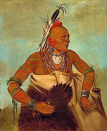
Before European contact, the area that today makes up Jasper county was the domain of the Osage Indians
who called themselves the Children of the Middle Waters (Ni-U-Kon-Ska). This was probably because their dominion encompassed the land between the Missouri
and Osage
rivers to the north, the Mississippi River
to the east, and the Arkansas River
to the south. To west were the great plains
where they hunted buffalo. By the late 17th century, the Osage were calling themselves Wah-Zha-Zhe.
The earliest record of European – Osage contact is a 1673 map by French Jesuit priest and explorer Jacques Marquette
. He noted the people he encountered as the Ouchage, his way of expressing the sound of the name with French spelling. A few years after the Marquette expedition, French explorers discovered a Little Osage village and called it Ouazhigi. French transliterations of the tribe's name settled on a spelling of Osage, which was also used by European Americans.
In 1682 Robert de La Salle canoed down the length of the Mississippi river to the Gulf of Mexico, naming the entire Mississippi basin “La Louisiane” in honor of Louis XIV. In 1699 Louisiana was named an administrative district of New France
therefore, as far as the Europeans (France, England and Spain) were concerned, the area of Jasper county was French territory. The French further divided the Louisiana district into an upper and lower parts with the Arkansas River being the dividing line.
With France and Spain’s defeat in the Seven Years War in 1763, France ceded Louisiana to Spain and the most of the rest New France to the British who also received Florida from Spain. The Spanish District of New Madrid, containing present day Jasper county, was the southern most of the five Spanish districts comprising Upper Louisiana. France regained control of Louisiana through the secret treaty of San Ildefonso
in 1800 but Napoleon decide to sell the territory to the United States in 1803.
The Osage began treaty-making with the United States in 1808 with the first cession of lands in Missouri (Osage Treaty). The Osage moved from their homelands on the Osage River in 1808 and moved to the Jasper county area of western Missouri. In 1825, the Osages ceded their traditional lands across Missouri, Arkansas, and Oklahoma. They were first moved onto a southeast Kansas reservation in the Cherokee Strip, on which the city of Independence, Kansas now sits and finally to Indian Territory
in 1872.
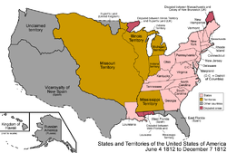 The Upper Louisiana Territory, including the Jasper County area, was renamed the Missouri Territory
on June 4, 1812 to avoid confusion with the state of Louisiana which joined the Union in 1812 and the New Madrid District became New Madrid County. Old Lawrence County was established in 1815 from New Madrid County west of the St. Francis River
and north of Arkansas cCunty and consisted of all of present-day southwestern Missouri and part of northwestern Arkansas.
Lawrence county was short-lived, however, as three years later (1818) it was combined with part of Cape Girardeau County and renamed Wayne County. By 1819, Arkansas Territory
had been created, and Wayne county lost some of its area but still consisted of most of southern Missouri from present-day Wayne county west to the Kansas State Line and south along the Arkansas State Line.
In 1820 all of Missouri Territory was admitted into the Union as the state of Missouri and in 1831 Crawford county was carved out of the original Wayne. This new division covered all the southern part of Missouri and included in its boundaries, Jasper County. This alignment was also short lived as in 1833 Greene County was split from Crawford County from the Niangua River
west to the Kansas State Line.
January 5, 1835, a big piece was cut out of Greene and organized as "Barry" county. In 1838 Barry county was divided into four parts to be called Barry, Dade, Newton and Jasper counties. At this time Jasper was not a full fledged county but was attached to Newton County and it would not be until 1841.
A temporary seat of justice was established, Thursday, February 25, 1841 in the home of George Hornback. It was a 12×16 foot log cabin, one and a half miles northwest of Carthage on Spring River
. Samuel M. Coolley, Jeremiah Cravens and Samuel B. Bright were the first justices of the Jasper County Court. John P. Osborn, the first sheriff, was ordered to give public notice that the county court of Jasper County shall meet in the home of George Hornback until the permanent seat of justice was established.
A permanent county seat was chosen in March 1842 and designated by the name of Carthage. A one story single-room wooden structure with a large door in the south, was completed on June 29, 1842, and was located on the north side of the present public square in Carthage. This courthouse was later replaced by a larger two story brick & stone structure that was completed in 1854, which also functioned as the county jail.
By the start of the American Civil War
in 1861 there were several small river mill settlements, some mining camps and about nine or ten towns (seven platted) in Jasper County, Missouri. The county seat of Carthage, Missouri
had an estimated population between four and five hundred at that time. The newer brick courthouse was used as a hospital during the American Civil War and was destroyed by fire during fighting in October 1863. By the end of the Civil War Carthage had been evacuated and completely destroyed, and much of Jasper County lay in ruins. By order of the governor the courthouse was relocated to the schoolhouse at Cave Springs (near present day La Russell, Missouri
) in 1865. Other temporary locations within the county were later used over the next three decades until the current Jasper County Courthouse was constructed on the Carthage square in the mid 1890s.
in 1861 and second battle in 1863.
¹defunct
Missouri
Missouri is a US state located in the Midwestern United States, bordered by Iowa, Illinois, Kentucky, Tennessee, Arkansas, Oklahoma, Kansas and Nebraska. With a 2010 population of 5,988,927, Missouri is the 18th most populous state in the nation and the fifth most populous in the Midwest. It...
. It is included in the Joplin, Missouri Metropolitan Statistical Area. The 2010 total population of Jasper County was 117,404. It is the ninth most populous county in Missouri. Its county seat
County seat
A county seat is an administrative center, or seat of government, for a county or civil parish. The term is primarily used in the United States....
is Carthage
Carthage, Missouri
Carthage is a city in Jasper County, Missouri, United States. The population was 14,378 at the 2010 census. It is the county seat of Jasper County and is nicknamed "America's Maple Leaf City."...
, making it one of the few counties whose largest city, Joplin
Joplin, Missouri
Joplin is a city in southern Jasper County and northern Newton County in the southwestern corner of the US state of Missouri. Joplin is the largest city in Jasper County, though it is not the county seat. As of the 2010 census, the city population was 50,150...
, is not the county seat. The county was organized in 1841 and named for Sgt. William Jasper
William Jasper
William Jasper was a noted American soldier in the Revolutionary War. He was a sergeant in the 2nd South Carolina Regiment.Jasper distinguished himself in the defense of Fort Moultrie on June 28, 1776...
, a hero of the American Revolutionary War
American Revolutionary War
The American Revolutionary War , the American War of Independence, or simply the Revolutionary War, began as a war between the Kingdom of Great Britain and thirteen British colonies in North America, and ended in a global war between several European great powers.The war was the result of the...
.
Geography
According to the 2000 census, the county has a total area of 641.32 square miles (1,661 km²), of which 639.73 square miles (1,656.9 km²) (or 99.75%) is land and 1.59 square miles (4.1 km²) (or 0.25%) is water.Demographics
As of the census of 2010, there were 117,404 people, 45,639 households, and 30,202 families residing in the county. The population density was 164 people per square mile (63/km²). There were 50,668 housing units at an average density of 71 per square mile (28/km²). The racial makeup of the county was 88.2% WhiteRace (United States Census)
Race and ethnicity in the United States Census, as defined by the Federal Office of Management and Budget and the United States Census Bureau, are self-identification data items in which residents choose the race or races with which they most closely identify, and indicate whether or not they are...
, 1.9% Black
Race (United States Census)
Race and ethnicity in the United States Census, as defined by the Federal Office of Management and Budget and the United States Census Bureau, are self-identification data items in which residents choose the race or races with which they most closely identify, and indicate whether or not they are...
or African American
Race (United States Census)
Race and ethnicity in the United States Census, as defined by the Federal Office of Management and Budget and the United States Census Bureau, are self-identification data items in which residents choose the race or races with which they most closely identify, and indicate whether or not they are...
, 1.5% Native American
Race (United States Census)
Race and ethnicity in the United States Census, as defined by the Federal Office of Management and Budget and the United States Census Bureau, are self-identification data items in which residents choose the race or races with which they most closely identify, and indicate whether or not they are...
, 1.0% Asian
Race (United States Census)
Race and ethnicity in the United States Census, as defined by the Federal Office of Management and Budget and the United States Census Bureau, are self-identification data items in which residents choose the race or races with which they most closely identify, and indicate whether or not they are...
, 0.2% Pacific Islander
Race (United States Census)
Race and ethnicity in the United States Census, as defined by the Federal Office of Management and Budget and the United States Census Bureau, are self-identification data items in which residents choose the race or races with which they most closely identify, and indicate whether or not they are...
, 3.9% from other races
Race (United States Census)
Race and ethnicity in the United States Census, as defined by the Federal Office of Management and Budget and the United States Census Bureau, are self-identification data items in which residents choose the race or races with which they most closely identify, and indicate whether or not they are...
, and 3.2% from two or more races. 6.8% of the population were Hispanic
Race (United States Census)
Race and ethnicity in the United States Census, as defined by the Federal Office of Management and Budget and the United States Census Bureau, are self-identification data items in which residents choose the race or races with which they most closely identify, and indicate whether or not they are...
or Latino
Race (United States Census)
Race and ethnicity in the United States Census, as defined by the Federal Office of Management and Budget and the United States Census Bureau, are self-identification data items in which residents choose the race or races with which they most closely identify, and indicate whether or not they are...
of any race.
There were 45,639 households out of which 30.8% had children under the age of 18 living with them, 48.7% were married couples living together, 12.4% had a female householder with no husband present, and 33.8% were non-families. 33.4% of all households were made up of individuals and 24.8% had someone living alone who was 65 years of age or older. The average household size was 2.52 and the average family size was 3.05
In the county the population was spread out with 27.17% under the age of 19, 7.4% from 20 to 24, 25.11% from 25 to 44, 22.24% from 45 to 64, and 12.14% who were 65 years of age or older. The median age was 35.1 years. For every 100 females there were 94.10 males. For every 100 females age 18 and over, there were 90.20 males.
The median income for a household in the county was $31,323, and the median income for a family was $37,611. Males had a median income of $28,573 versus $20,386 for females. The per capita income for the county was $16,227. About 10.40% of families and 14.50% of the population were below the poverty line, including 19.20% of those under age 18 and 10.30% of those age 65 or over.
History
Osage Nation
Before European contact, the area that today makes up Jasper county was the domain of the Osage Indians
Osage Nation
The Osage Nation is a Native American Siouan-language tribe in the United States that originated in the Ohio River valley in present-day Kentucky. After years of war with invading Iroquois, the Osage migrated west of the Mississippi River to their historic lands in present-day Arkansas, Missouri,...
who called themselves the Children of the Middle Waters (Ni-U-Kon-Ska). This was probably because their dominion encompassed the land between the Missouri
Missouri River
The Missouri River flows through the central United States, and is a tributary of the Mississippi River. It is the longest river in North America and drains the third largest area, though only the thirteenth largest by discharge. The Missouri's watershed encompasses most of the American Great...
and Osage
Osage River
The Osage River is a tributary of the Missouri River in central Missouri in the United States. The Osage River is one of the larger rivers in Missouri. The river drains a mostly rural area of . The watershed includes an area of east-central Kansas and a large portion of west-central and central...
rivers to the north, the Mississippi River
Mississippi River
The Mississippi River is the largest river system in North America. Flowing entirely in the United States, this river rises in western Minnesota and meanders slowly southwards for to the Mississippi River Delta at the Gulf of Mexico. With its many tributaries, the Mississippi's watershed drains...
to the east, and the Arkansas River
Arkansas River
The Arkansas River is a major tributary of the Mississippi River. The Arkansas generally flows to the east and southeast as it traverses the U.S. states of Colorado, Kansas, Oklahoma, and Arkansas. The river's initial basin starts in the Western United States in Colorado, specifically the Arkansas...
to the south. To west were the great plains
Great Plains
The Great Plains are a broad expanse of flat land, much of it covered in prairie, steppe and grassland, which lies west of the Mississippi River and east of the Rocky Mountains in the United States and Canada. This area covers parts of the U.S...
where they hunted buffalo. By the late 17th century, the Osage were calling themselves Wah-Zha-Zhe.
The earliest record of European – Osage contact is a 1673 map by French Jesuit priest and explorer Jacques Marquette
Jacques Marquette
Father Jacques Marquette S.J. , sometimes known as Père Marquette, was a French Jesuit missionary who founded Michigan's first European settlement, Sault Ste. Marie, and later founded St. Ignace, Michigan...
. He noted the people he encountered as the Ouchage, his way of expressing the sound of the name with French spelling. A few years after the Marquette expedition, French explorers discovered a Little Osage village and called it Ouazhigi. French transliterations of the tribe's name settled on a spelling of Osage, which was also used by European Americans.
In 1682 Robert de La Salle canoed down the length of the Mississippi river to the Gulf of Mexico, naming the entire Mississippi basin “La Louisiane” in honor of Louis XIV. In 1699 Louisiana was named an administrative district of New France
New France
New France was the area colonized by France in North America during a period beginning with the exploration of the Saint Lawrence River by Jacques Cartier in 1534 and ending with the cession of New France to Spain and Great Britain in 1763...
therefore, as far as the Europeans (France, England and Spain) were concerned, the area of Jasper county was French territory. The French further divided the Louisiana district into an upper and lower parts with the Arkansas River being the dividing line.
With France and Spain’s defeat in the Seven Years War in 1763, France ceded Louisiana to Spain and the most of the rest New France to the British who also received Florida from Spain. The Spanish District of New Madrid, containing present day Jasper county, was the southern most of the five Spanish districts comprising Upper Louisiana. France regained control of Louisiana through the secret treaty of San Ildefonso
Treaty of San Ildefonso
San Ildefonso is a town in central Spain, the summer residence of the Kings of Spain, where several treaties were signed; each is referred to, in context, as the Treaty of San Ildefonso...
in 1800 but Napoleon decide to sell the territory to the United States in 1803.
The Osage began treaty-making with the United States in 1808 with the first cession of lands in Missouri (Osage Treaty). The Osage moved from their homelands on the Osage River in 1808 and moved to the Jasper county area of western Missouri. In 1825, the Osages ceded their traditional lands across Missouri, Arkansas, and Oklahoma. They were first moved onto a southeast Kansas reservation in the Cherokee Strip, on which the city of Independence, Kansas now sits and finally to Indian Territory
Indian Territory
The Indian Territory, also known as the Indian Territories and the Indian Country, was land set aside within the United States for the settlement of American Indians...
in 1872.
Missouri Territory
Missouri Territory
The Territory of Missouri was an organized incorporated territory of the United States that existed from June 4, 1812 until August 10, 1821, when the southeastern portion of the territory was admitted to the Union as the State of Missouri.-History:...
on June 4, 1812 to avoid confusion with the state of Louisiana which joined the Union in 1812 and the New Madrid District became New Madrid County. Old Lawrence County was established in 1815 from New Madrid County west of the St. Francis River
St. Francis River
The Saint Francis River is a tributary of the Mississippi River, about long, in southeastern Missouri and northeastern Arkansas in the United States...
and north of Arkansas cCunty and consisted of all of present-day southwestern Missouri and part of northwestern Arkansas.
Lawrence county was short-lived, however, as three years later (1818) it was combined with part of Cape Girardeau County and renamed Wayne County. By 1819, Arkansas Territory
Arkansas Territory
The Territory of Arkansas, initially organized as the Territory of Arkansaw, was an organized incorporated territory of the United States that existed from July 4, 1819 until June 15, 1836, when the final extent of the territory was admitted to the Union as the State of Arkansas.-History:The...
had been created, and Wayne county lost some of its area but still consisted of most of southern Missouri from present-day Wayne county west to the Kansas State Line and south along the Arkansas State Line.
In 1820 all of Missouri Territory was admitted into the Union as the state of Missouri and in 1831 Crawford county was carved out of the original Wayne. This new division covered all the southern part of Missouri and included in its boundaries, Jasper County. This alignment was also short lived as in 1833 Greene County was split from Crawford County from the Niangua River
Niangua River
The Niangua River is a tributary of the Osage River in the Ozarks region of southern and central Missouri in the United States. Via the Osage and Missouri rivers it is part of the watershed of the Mississippi River.-Course:...
west to the Kansas State Line.
January 5, 1835, a big piece was cut out of Greene and organized as "Barry" county. In 1838 Barry county was divided into four parts to be called Barry, Dade, Newton and Jasper counties. At this time Jasper was not a full fledged county but was attached to Newton County and it would not be until 1841.
County organization
On January 29, 1841 the Missouri Legislature enacted a bill authorizing the organization of Jasper county and was named in honor of Sergeant William Jasper, a hero in the American Revolutionary War. The County Court first divided the area into three townships: North Fork, Center Creek and Marion but later it was divided into 15 townships which remain in an unincorporated status to the present time.A temporary seat of justice was established, Thursday, February 25, 1841 in the home of George Hornback. It was a 12×16 foot log cabin, one and a half miles northwest of Carthage on Spring River
Spring River (Missouri)
The Spring River is a waterway located in southwestern Missouri, southeastern Kansas, and northeastern Oklahoma. It begins in northern Barry County, Missouri south of Aurora, flows north of Verona and turns west across Lawrence and Jasper counties, passing through Carthage, before crossing into...
. Samuel M. Coolley, Jeremiah Cravens and Samuel B. Bright were the first justices of the Jasper County Court. John P. Osborn, the first sheriff, was ordered to give public notice that the county court of Jasper County shall meet in the home of George Hornback until the permanent seat of justice was established.
A permanent county seat was chosen in March 1842 and designated by the name of Carthage. A one story single-room wooden structure with a large door in the south, was completed on June 29, 1842, and was located on the north side of the present public square in Carthage. This courthouse was later replaced by a larger two story brick & stone structure that was completed in 1854, which also functioned as the county jail.
By the start of the American Civil War
American Civil War
The American Civil War was a civil war fought in the United States of America. In response to the election of Abraham Lincoln as President of the United States, 11 southern slave states declared their secession from the United States and formed the Confederate States of America ; the other 25...
in 1861 there were several small river mill settlements, some mining camps and about nine or ten towns (seven platted) in Jasper County, Missouri. The county seat of Carthage, Missouri
Carthage, Missouri
Carthage is a city in Jasper County, Missouri, United States. The population was 14,378 at the 2010 census. It is the county seat of Jasper County and is nicknamed "America's Maple Leaf City."...
had an estimated population between four and five hundred at that time. The newer brick courthouse was used as a hospital during the American Civil War and was destroyed by fire during fighting in October 1863. By the end of the Civil War Carthage had been evacuated and completely destroyed, and much of Jasper County lay in ruins. By order of the governor the courthouse was relocated to the schoolhouse at Cave Springs (near present day La Russell, Missouri
La Russell, Missouri
La Russell is a city in Jasper County, Missouri, United States. The population was 114 at the 2010 census. It is part of the Joplin, Missouri Metropolitan Statistical Area.-Geography:La Russell is located at ....
) in 1865. Other temporary locations within the county were later used over the next three decades until the current Jasper County Courthouse was constructed on the Carthage square in the mid 1890s.
Towns established prior to the Civil War
| Current Town Name | Accepted Date Founded | Official Date of Plat Plat A plat in the U.S. is a map, drawn to scale, showing the divisions of a piece of land. Other English-speaking countries generally call such documents a cadastral map or plan.... |
Notes |
|---|---|---|---|
| Sarcoxie Sarcoxie, Missouri Sarcoxie is a city in Jasper County, Missouri, United States. The population was 1,330 at the 2010 census. It is part of the Joplin, Missouri Metropolitan Statistical Area.- History :... |
1833 | 1840 | The first settlement in Jasper County Missouri, initially known as Centerville. The first settler was Thackeray Vivion in 1831. |
| (Old) Jasper | 1840 | 1842 | Was located northeast of Carthage and no longer exists. Later, another settlement named Jasper existed southeast of Carthage. The present town of Jasper, Missouri Jasper, Missouri Jasper is a city in Jasper County, Missouri, United States. The population within the city limits was 931 at the 2010 census. It is part of the Joplin, Missouri Metropolitan Statistical Area.-Geography:Jasper is located at .... , north of Carthage, is a different community previously known as Coon Creek settlement or "Midway." |
| Carthage Carthage, Missouri Carthage is a city in Jasper County, Missouri, United States. The population was 14,378 at the 2010 census. It is the county seat of Jasper County and is nicknamed "America's Maple Leaf City."... |
1841 | 1842 | Historic Carthage was planned from the start with the purpose of being the Jasper County seat and was promptly rebuilt after being completely destroyed during the Civil War. The current Jasper County Courthouse was erected in the mid-1890s. |
| (Old) Sherwood | 1846 | 1856 | First called Rural and was located near present day Webb City Webb City, Missouri Webb City is a city in Jasper County, Missouri, United States. The population was 10,996 at the 2010 census. It is part of the Joplin, Missouri Metropolitan Statistical Area.-Geography:Webb City is located at .... . It was not rebuilt after being destroyed during the Civil War and no longer exists. |
| Oronogo Oronogo, Missouri Oronogo is a city in Jasper County, Missouri, United States. The population was 2,381 at the 2010 census. It is part of the Joplin, Missouri Metropolitan Statistical Area.-Name:... |
1848 | 1856 | Known as Minersville around the time of the Civil War, it evolved from early mining camps and had other names such as Leadville Hollow. The Post Office had also used the name Center Mines. |
| (Old) Medoc | 1848 | After the Civil War | Started as an old Indian trading post near the Kansas Kansas Kansas is a US state located in the Midwestern United States. It is named after the Kansas River which flows through it, which in turn was named after the Kansa Native American tribe, which inhabited the area. The tribe's name is often said to mean "people of the wind" or "people of the south... state line, it was destroyed during the Civil War and later resettled, but the plat was abandoned by the 20th century and the town no longer exists. |
| Avilla Avilla, Missouri Avilla is a rural village in Jasper County, Missouri, United States. The population was 125 at the 2010 census. It is part of the Joplin, Missouri Metropolitan Statistical Area.-Geography:... |
1856 | 1858 | Founded by merchant-landowners as a business center on the edge of the frontier in the mid-1850s. The citizens of Avilla formed a town militia for defense at the beginning of the Civil War and the site later served as a Union Army garrison (Enrolled Missouri Militia Enrolled Missouri Militia The Enrolled Missouri Militia was a state militia organization of Missouri in 1862 during the American Civil War. It was a part-time force whose primary purpose was to serve as garrison and infrastructure guards, both to augment the Unionist Missouri State Militia in defense versus raids and to... ), subsequently prevailing intact and undamaged after the war. The town's growth was ultimately stunted after being bypassed by the railroad in the latter 19th century and it remains a small village in the 21st century today. |
| Fidelity Fidelity, Missouri Fidelity is a village in Jasper County, Missouri, in the United States. The population was 257 at the 2010 census, at which time it was a town. It is part of the Joplin, Missouri Metropolitan Statistical Area.-Geography:... |
1856 | After the Civil War | Considered to have been founded by William Cloe about the same time as Avilla for similar reasons (mirroring it in some ways), Fidelity was not platted until after the Civil War. |
| Waco Waco, Missouri Waco is a city in Jasper County, Missouri, United States. The population was 87 at the 2010 census, at which time it was a town. It is part of the Joplin, Missouri Metropolitan Statistical Area.-Geography:Waco is located at .... |
1857 | After the Civil War, 1878 | Started as an old trading post first known as Loshick |
| (Old) Preston | 1859 | 1860 | A village northwest of Carthage, plat abandoned and town no longer exists. |
Recent history
The county adopted an official flag in 2001, which was unveiled during the county's 160th birthday celebration. The flag depicts the county courthouse surrounded by 15 stars representing Jasper County’s 15 townships. The center blue and red stars memorialize the struggle in Jasper County during the Civil War years, including the Battle of CarthageBattle of Carthage (1861)
-References:* Lee, Guy Carlton, and Francis Newtun Thorpe, editors. The History of North America. Philadelphia: George Barrie and Sons, 1905.* Monhegan, Jay. Civil War on the Western Border: 1854-1865. Boston: Little, Brown, 1956.*...
in 1861 and second battle in 1863.
Cities and towns
|
Carterville, Missouri Carterville is a city in Jasper County, Missouri, United States. The population was 1,891 at the 2010 census. It is part of the Joplin, Missouri Metropolitan Statistical Area.-Geography:... Carthage, Missouri Carthage is a city in Jasper County, Missouri, United States. The population was 14,378 at the 2010 census. It is the county seat of Jasper County and is nicknamed "America's Maple Leaf City."... Carytown, Missouri Carytown is a village in Jasper County, Missouri, United States. The population was 271 at the 2010 census. It is part of the Joplin, Missouri Metropolitan Statistical Area.-Geography:Carytown is located at .... Duenweg, Missouri Duenweg is a city in Jasper County, Missouri, United States. The population was 1,121 at the 2010 census. It is part of the Joplin, Missouri Metropolitan Statistical Area.-Geography:Duenweg is located at .... Duquesne, Missouri Duquesne is a village in Jasper County, Missouri, United States. The population was 1,763 at the 2010 census. It is part of the Joplin, Missouri Metropolitan Statistical Area.-Geography:Duquesne is located at .... Fidelity, Missouri Fidelity is a village in Jasper County, Missouri, in the United States. The population was 257 at the 2010 census, at which time it was a town. It is part of the Joplin, Missouri Metropolitan Statistical Area.-Geography:... |
Jasper, Missouri Jasper is a city in Jasper County, Missouri, United States. The population within the city limits was 931 at the 2010 census. It is part of the Joplin, Missouri Metropolitan Statistical Area.-Geography:Jasper is located at .... Joplin, Missouri Joplin is a city in southern Jasper County and northern Newton County in the southwestern corner of the US state of Missouri. Joplin is the largest city in Jasper County, though it is not the county seat. As of the 2010 census, the city population was 50,150... Kendricktown, Missouri Kendricktown is an unincorporated community in Jasper County, Missouri, United States. It is located on Missouri Supplemental Route V immediately north of the city limits of Carthage and just south of U.S. Route 71... La Russell, Missouri La Russell is a city in Jasper County, Missouri, United States. The population was 114 at the 2010 census. It is part of the Joplin, Missouri Metropolitan Statistical Area.-Geography:La Russell is located at .... Maxville, Missouri Maxville is a former town on U.S. Route 66, about two miles east of Carthage in Jasper County, Missouri, United States. The community is part of the Joplin, Missouri Metropolitan Statistical Area.... Neck City, Missouri Neck City is a city in Jasper County, Missouri, United States. The population was 186 at the 2010 census. It is part of the Joplin, Missouri Metropolitan Statistical Area.-Geography:Neck City is located at .... |
Oakland Park, Missouri Oakland Park is a former village in Jasper County, Missouri. It was located on U.S. Route 71 in the Joplin area. Its population in 1990 was 89. It incorporated in 1957; in 1996, it merged with nearby Webb City.... ¹ Oronogo, Missouri Oronogo is a city in Jasper County, Missouri, United States. The population was 2,381 at the 2010 census. It is part of the Joplin, Missouri Metropolitan Statistical Area.-Name:... Purcell, Missouri Purcell is a city in Jasper County, Missouri, United States. The population was 408 at the 2010 census. It is part of the Joplin, Missouri Metropolitan Statistical Area.-Geography:Purcell is located at .... Reeds, Missouri Reeds is a city in Jasper County, Missouri, United States. The population was 95 at the 2010 census, at which time it was a town. It is part of the Joplin, Missouri Metropolitan Statistical Area... Sarcoxie, Missouri Sarcoxie is a city in Jasper County, Missouri, United States. The population was 1,330 at the 2010 census. It is part of the Joplin, Missouri Metropolitan Statistical Area.- History :... Waco, Missouri Waco is a city in Jasper County, Missouri, United States. The population was 87 at the 2010 census, at which time it was a town. It is part of the Joplin, Missouri Metropolitan Statistical Area.-Geography:Waco is located at .... |
Webb City, Missouri Webb City is a city in Jasper County, Missouri, United States. The population was 10,996 at the 2010 census. It is part of the Joplin, Missouri Metropolitan Statistical Area.-Geography:Webb City is located at .... |
¹defunct
Townships
- Joplin Township Pop: 42,173
- Galena Township Pop: 27,239
- Marion Township Pop: 15,137
- Mineral Township Pop: 9,100
- Twin Groves Township- Pop: 6,556
- Jackson Township Pop: 4,954
- Sarcoxie Township Pop: 3,043
- Madison Township Pop: 2,502
- Union Township Pop: 2,296
- Preston Township Pop: 1,446
- Duval Township Pop: 839
- McDonald Township Pop: 810
- Jasper Township Pop: 601
- Sheridan Township Pop: 412
- Lincoln Township Pop: 296
Adjacent counties
- Barton County (north)
- Dade County (northeast)
- Lawrence County (east)
- Newton County (south)
- Cherokee County, KansasCherokee County, KansasCherokee County is a county located in Southeast Kansas, in the Central United States. As of the 2010 census, the county population was 21,603. Its county seat is Columbus, and its most populous city is Baxter Springs...
(west) - Crawford County, KansasCrawford County, KansasCrawford County is a county located in southeastern Kansas in the United States. As of the 2010 census, the county population was 39,134. Its county seat is Girard, and its most populous city is Pittsburg. The county was named in honor of Samuel J. Crawford, Governor of Kansas...
(northwest)
Major highways
 Interstate 44
 U.S. Route 66 (1926–1985)
 U.S. Route 71,
  Interstate 49Interstate 49Interstate 49 is currently an intrastate Interstate Highway located entirely within the state of Louisiana in the southern United States. Its southern terminus is in Lafayette, Louisiana, at Interstate 10 while its northern terminus is in Shreveport, Louisiana, at Interstate 20.-Route...
(in progress) Route 37
 Route 43
 Route 66
 Route 96
 Route 171
Cemeteries
- Alexander Cemetery – Latitude 37.1372 and Longitude −94.3875
- Carterville Cemetery – Latitude 37.1678359 and Longitude −94.4393924
- Fidelity Cemetery – Latitude 37.2894989 and Longitude −94.4621731
- Peace Church Cemetery – Latitude 37.1231152 and Longitude −94.5474492
- Pine Cemetery – Latitude 37.2894989 and Longitude −94.4621731
- Stone Cemetery – Latitude 37.0578392 and Longitude −94.3549436
See also
- National Register of Historic Places listings in Jasper County, Missouri
External links
- Digitized 1930 Plat Book of Jasper County from University of MissouriUniversity of MissouriThe University of Missouri System is a state university system providing centralized administration for four universities, a health care system, an extension program, five research and technology parks, and a publishing press. More than 64,000 students are currently enrolled at its four campuses...
Division of Special Collections, Archives, and Rare Books - http://2010.census.gov/2010census/popmap/