

Lincolnville, Kansas
Encyclopedia
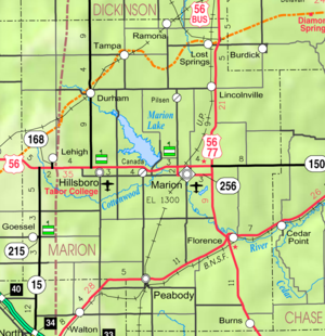
Lincolnville is a city in Marion County
, Kansas
, United States
. As of the 2010 census, the city population was 203.
. In 1803, most of modern Kansas
was secured by the United States as part of the Louisiana Purchase
. In 1855, Marion County, Kansas
, where Lincolnville is located, was founded.
The first settlers to the area were Heman Deal (1860) and Thomas Wise, Jr (1863). The first Lincolnville plat was filed by Robert C McAllister on May 18, 1872, but the patent from the United States government was not granted until August 23, 1878.
In 1887, the Chicago, Kansas and Nebraska Railway built a branch line north-south from Herington
through Lincolnville to Caldwell
. It foreclosed in 1891 and was taken over by Chicago, Rock Island and Pacific Railway, which shut down in 1980 and reorganized as Oklahoma, Kansas and Texas Railroad
, merged in 1988 with Missouri Pacific Railroad
, and finally merged in 1997 with Union Pacific Railroad
. Most locals still refer to this railroad as the "Rock Island".
, the city has a total area of 0.2 square mile (0.517997622 km²), all of it land.
(NRHP).
of 2000, there were 225 people, 94 households, and 59 families residing in the city. The population density
was 1,017.5 people per square mile (394.9/km²). There were 97 housing units at an average density of 438.7 per square mile (170.2/km²). The racial makeup of the city was 95.11% White, 1.33% Native American, 2.22% from other races
, and 1.33% from two or more races. Hispanic or Latino of any race were 4.44% of the population.
There were 94 households out of which 37.2% had children under the age of 18 living with them, 50.0% were married couples
living together, 7.4% had a female householder with no husband present, and 36.2% were non-families. 31.9% of all households were made up of individuals and 20.2% had someone living alone who was 65 years of age or older. The average household size was 2.39 and the average family size was 3.10.
In the city the population was spread out with 27.6% under the age of 18, 7.6% from 18 to 24, 31.1% from 25 to 44, 16.0% from 45 to 64, and 17.8% who were 65 years of age or older. The median age was 36 years. For every 100 females there were 94.0 males. For every 100 females age 18 and over, there were 89.5 males.
The median income for a household in the city was $36,563, and the median income for a family was $42,917. Males had a median income of $29,063 versus $25,000 for females. The per capita income
for the city was $16,319. About 9.3% of families and 9.6% of the population were below the poverty line, including 6.1% of those under the age of eighteen and 18.0% of those sixty five or over.
397. The high school is a member of T.E.E.N., a shared video teaching network between five area high schools. All students attend schools in Lost Springs
area.
which is about 5 blocks west of the highway.
Kansas
Schools
Historic
Maps
Marion County, Kansas
Marion County is a county located in the U.S. state of Kansas. As of the 2010 census, the county population was 12,660. The county seat is Marion...
, Kansas
Kansas
Kansas is a US state located in the Midwestern United States. It is named after the Kansas River which flows through it, which in turn was named after the Kansa Native American tribe, which inhabited the area. The tribe's name is often said to mean "people of the wind" or "people of the south...
, United States
United States
The United States of America is a federal constitutional republic comprising fifty states and a federal district...
. As of the 2010 census, the city population was 203.
19th century
For millennia, the land that is currently Kansas was inhabited by Native AmericansNative Americans in the United States
Native Americans in the United States are the indigenous peoples in North America within the boundaries of the present-day continental United States, parts of Alaska, and the island state of Hawaii. They are composed of numerous, distinct tribes, states, and ethnic groups, many of which survive as...
. In 1803, most of modern Kansas
History of Kansas
The history of Kansas, argued historian Carl L. Becker a century ago, reflects American ideals. He wrote: "The Kansas spirit is the American spirit double distilled. It is a new grafted product of American individualism, American idealism, American intolerance. Kansas is America in...
was secured by the United States as part of the Louisiana Purchase
Louisiana Purchase
The Louisiana Purchase was the acquisition by the United States of America of of France's claim to the territory of Louisiana in 1803. The U.S...
. In 1855, Marion County, Kansas
Marion County, Kansas
Marion County is a county located in the U.S. state of Kansas. As of the 2010 census, the county population was 12,660. The county seat is Marion...
, where Lincolnville is located, was founded.
The first settlers to the area were Heman Deal (1860) and Thomas Wise, Jr (1863). The first Lincolnville plat was filed by Robert C McAllister on May 18, 1872, but the patent from the United States government was not granted until August 23, 1878.
In 1887, the Chicago, Kansas and Nebraska Railway built a branch line north-south from Herington
Herington, Kansas
Herington is a city in Dickinson and Morris counties in the U.S. state of Kansas. Named after its founder, Monroe Davis Herington. As of the 2010 census, the city population was 2,526.-19th century:...
through Lincolnville to Caldwell
Caldwell, Kansas
Caldwell is a city in Sumner County, Kansas, United States. As of the 2010 census, the city population was 1,068.-19th century:In 1887, the Chicago, Kansas and Nebraska Railway built a branch line north-south from Herington to Caldwell...
. It foreclosed in 1891 and was taken over by Chicago, Rock Island and Pacific Railway, which shut down in 1980 and reorganized as Oklahoma, Kansas and Texas Railroad
Oklahoma, Kansas and Texas Railroad
-OKT I:The Oklahoma, Kansas and Texas Railroad , was originally created on May 29, 1980 after the demise of the Chicago, Rock Island and Pacific Railroad on March 31, 1980...
, merged in 1988 with Missouri Pacific Railroad
Missouri Pacific Railroad
The Missouri Pacific Railroad , also known as the MoPac, was one of the first railroads in the United States west of the Mississippi River. MoPac was a Class I railroad growing from dozens of predecessors and mergers, including the St. Louis, Iron Mountain and Southern Railway , Texas and Pacific...
, and finally merged in 1997 with Union Pacific Railroad
Union Pacific Railroad
The Union Pacific Railroad , headquartered in Omaha, Nebraska, is the largest railroad network in the United States. James R. Young is president, CEO and Chairman....
. Most locals still refer to this railroad as the "Rock Island".
Geography
Lincolnville is located at 38°29′38"N 96°57′42"W (38.493991, -96.961534). According to the United States Census BureauUnited States Census Bureau
The United States Census Bureau is the government agency that is responsible for the United States Census. It also gathers other national demographic and economic data...
, the city has a total area of 0.2 square mile (0.517997622 km²), all of it land.
Area attractions
Lincolnville has two buildings listed on the National Register of Historic PlacesNational Register of Historic Places
The National Register of Historic Places is the United States government's official list of districts, sites, buildings, structures, and objects deemed worthy of preservation...
(NRHP).
- Bethel School (NRHPNational Register of Historic PlacesThe National Register of Historic Places is the United States government's official list of districts, sites, buildings, structures, and objects deemed worthy of preservation...
), 5.25 miles east of Lincolnville on 290th Street. - Island Field Ranch House (NRHPNational Register of Historic PlacesThe National Register of Historic Places is the United States government's official list of districts, sites, buildings, structures, and objects deemed worthy of preservation...
), 3.5 miles south of Lincolnville on U.S. Route 77U.S. Route 77U.S. Route 77 is a north–south United States highway. It is unsigned in and around Dallas, Texas. Its historic segment through South Dakota and Minnesota was decommissioned with the advent of Interstate 29 but otherwise the route has been spared the decommissioning that has shortened other US...
.
Demographics
As of the censusCensus
A census is the procedure of systematically acquiring and recording information about the members of a given population. It is a regularly occurring and official count of a particular population. The term is used mostly in connection with national population and housing censuses; other common...
of 2000, there were 225 people, 94 households, and 59 families residing in the city. The population density
Population density
Population density is a measurement of population per unit area or unit volume. It is frequently applied to living organisms, and particularly to humans...
was 1,017.5 people per square mile (394.9/km²). There were 97 housing units at an average density of 438.7 per square mile (170.2/km²). The racial makeup of the city was 95.11% White, 1.33% Native American, 2.22% from other races
Race (United States Census)
Race and ethnicity in the United States Census, as defined by the Federal Office of Management and Budget and the United States Census Bureau, are self-identification data items in which residents choose the race or races with which they most closely identify, and indicate whether or not they are...
, and 1.33% from two or more races. Hispanic or Latino of any race were 4.44% of the population.
There were 94 households out of which 37.2% had children under the age of 18 living with them, 50.0% were married couples
Marriage
Marriage is a social union or legal contract between people that creates kinship. It is an institution in which interpersonal relationships, usually intimate and sexual, are acknowledged in a variety of ways, depending on the culture or subculture in which it is found...
living together, 7.4% had a female householder with no husband present, and 36.2% were non-families. 31.9% of all households were made up of individuals and 20.2% had someone living alone who was 65 years of age or older. The average household size was 2.39 and the average family size was 3.10.
In the city the population was spread out with 27.6% under the age of 18, 7.6% from 18 to 24, 31.1% from 25 to 44, 16.0% from 45 to 64, and 17.8% who were 65 years of age or older. The median age was 36 years. For every 100 females there were 94.0 males. For every 100 females age 18 and over, there were 89.5 males.
The median income for a household in the city was $36,563, and the median income for a family was $42,917. Males had a median income of $29,063 versus $25,000 for females. The per capita income
Per capita income
Per capita income or income per person is a measure of mean income within an economic aggregate, such as a country or city. It is calculated by taking a measure of all sources of income in the aggregate and dividing it by the total population...
for the city was $16,319. About 9.3% of families and 9.6% of the population were below the poverty line, including 6.1% of those under the age of eighteen and 18.0% of those sixty five or over.
Government
The Lincolnville government consists of a mayor and five council members. The council meets the 1st Monday of each month at 7PM.- City Hall, 218 W Main St.
- Fire Department, 307 W Main St.
- Police Department.
- U.S. Post Office, 319 S Adams St.
Primary and secondary education
Lincolnville is part of Unified School DistrictUnified school district
A unified school district or unit school district is a school district which includes both primary school and high school under the same district control....
397. The high school is a member of T.E.E.N., a shared video teaching network between five area high schools. All students attend schools in Lost Springs
Lost Springs, Kansas
Lost Springs is a city in Marion County, Kansas, United States. It was named for the old lost spring near the city. As of the 2010 census, the city population was 70.-19th century:...
area.
- Centre High SchoolCentre High SchoolCentre High School is located 5 miles south of Lost Springs and 2 miles north of Lincolnville along U.S. Highway 77 in Kansas. It is the only high school in the School District.-History:...
, located between Lost SpringsLost Springs, KansasLost Springs is a city in Marion County, Kansas, United States. It was named for the old lost spring near the city. As of the 2010 census, the city population was 70.-19th century:...
and Lincolnville. - Centre Junior High School, located between Lost SpringsLost Springs, KansasLost Springs is a city in Marion County, Kansas, United States. It was named for the old lost spring near the city. As of the 2010 census, the city population was 70.-19th century:...
and Lincolnville. - Centre Middle School, located between Lost SpringsLost Springs, KansasLost Springs is a city in Marion County, Kansas, United States. It was named for the old lost spring near the city. As of the 2010 census, the city population was 70.-19th century:...
and Lincolnville. - Centre Grade School, located in Lost SpringsLost Springs, KansasLost Springs is a city in Marion County, Kansas, United States. It was named for the old lost spring near the city. As of the 2010 census, the city population was 70.-19th century:...
.
Infrastructure
Transportation
The U.S. Route 77 highway runs through the east side of Lincolnville and almost parallel to the Union Pacific RailroadUnion Pacific Railroad
The Union Pacific Railroad , headquartered in Omaha, Nebraska, is the largest railroad network in the United States. James R. Young is president, CEO and Chairman....
which is about 5 blocks west of the highway.
Utilities
- Internet
- Fiber Optics is provided by TCT.
- Satellite is provided by HughesNet, StarBandStarBandStarBand is a two-way satellite broadband Internet service available in the U.S.. StarBand Communications Inc. was initially a joint venture between Gilat Satellite Networks, EchoStar and Microsoft, and the StarBand service was launched in 2000. StarBand Communications filed for Chapter 11...
, WildBlue.
- TV
- Fiber Optics is provided by TCT.
- Cable is provided by Eagle Communications.
- Satellite is provided by DirecTVDirecTVDirecTV is an American direct broadcast satellite service provider and broadcaster based in El Segundo, California. Its satellite service, launched on June 17, 1994, transmits digital satellite television and audio to households in the United States, Latin America, and the Anglophone Caribbean. ...
, Dish NetworkDish NetworkDish Network Corporation is the second largest pay TV provider in the United States, providing direct broadcast satellite service—including satellite television, audio programming, and interactive television services—to 14.337 million commercial and residential customers in the United States. Dish...
. - Terrestrial is provided by regional digital TVDigital televisionDigital television is the transmission of audio and video by digital signals, in contrast to the analog signals used by analog TV...
stations.
- Telephone
- Fiber Optics is provided by TCT.
- Electricity
- Rural is provided by Flint Hills RECA.
See also
- Centre High SchoolCentre High SchoolCentre High School is located 5 miles south of Lost Springs and 2 miles north of Lincolnville along U.S. Highway 77 in Kansas. It is the only high school in the School District.-History:...
- National Register of Historic Places listings in Marion County, KansasNational Register of Historic Places listings in Marion County, KansasThis is a list of the National Register of Historic Places listings in Marion County, Kansas.This is intended to be a complete list of the properties and districts on the National Register of Historic Places in Marion County, Kansas, United States...
- Historical Maps of Marion County, KansasMarion County, KansasMarion County is a county located in the U.S. state of Kansas. As of the 2010 census, the county population was 12,660. The county seat is Marion...
Further reading
Marion County- Marion County Kansas - Past and Present; Sondra Van Meter; MB Publishing House in Hillsboro, KS; LCCN 72-92041; 344 pages; 1972.
- Standard Atlas of Marion County, Kansas; Geo A. Ogle & Co; 1902.
- World War Roll of Honor, Marion County Kansas, 1917-1920; Mrs Alexander and Mrs Dean of Marion, Kansas; 221 pages; 1920.
- The Early Schools Of Marion County, Kansas; Wilma Stewart Stallwitz; Located at Peabody Township Library; 33 pages; November 11, 1960.
Kansas
- Kansas: A Cyclopedia Of State History, Embracing Events, Institutions, Industries, Counties, Cities, Towns, Prominent Persons, Etc; Frank W. Blackmar; Standard Publishing Co; 1912.
- History Of The State of Kansas; William G. Cutler; A.T. Andreas Publisher; 1883.
External links
CitySchools
- USD 397, Centre school district for Lincolnville, Lost SpringsLost Springs, KansasLost Springs is a city in Marion County, Kansas, United States. It was named for the old lost spring near the city. As of the 2010 census, the city population was 70.-19th century:...
, PilsenPilsen, KansasPilsen is an unincorporated community in Marion County, Kansas, United States. It is named after the city Plzeň in Czech Republic, formerly Bohemia.-19th century:...
, TampaTampa, KansasTampa is a city in Marion County, Kansas, United States. As of the 2010 census, the city population was 112.-19th century:For millennia, the land that is currently Kansas was inhabited by Native Americans. In 1803, most of modern Kansas was secured by the United States as part of the Louisiana...
, RamonaRamona, KansasRamona is a city in Marion County, Kansas, United States. As of the 2010 census, the city population was 187.-19th century:For millennia, the land that is currently Kansas was inhabited by Native Americans. The city name is a spanish name. Land ownership of the Ramona area dates back when the...
, AntelopeAntelope, KansasAntelope is an unincorporated community in Marion County, Kansas, United States. Antelope got its name from Antelope grazing near where the first school was being built.-19th century:...
, BurdickBurdick, KansasBurdick is an unincorporated community in southwestern Morris County, Kansas, United States. It lies along local roads south-southwest of the city of Council Grove, the county seat of Morris County. Its elevation is 1,453 feet , and it is located at...
, nearby rural areas of MarionMarion County, KansasMarion County is a county located in the U.S. state of Kansas. As of the 2010 census, the county population was 12,660. The county seat is Marion...
/ MorrisMorris County, KansasMorris County is a county located in the U.S. state of Kansas. As of the 2010 census, the county population was 5,923. The largest city and county seat is Council Grove.-19th century:...
/ DickinsonDickinson County, KansasDickinson County is a county located in Central Kansas, in the Central United States. As of the 2010 census, the county population was 19,754. Its county seat and most populous city is Abilene. It was named in honor of Daniel S. Dickinson.-19th century:In 1887, Mr. Herington successfully got...
/ ChaseChase County, KansasChase County is a county located in Central Kansas, in the Central United States. As of the 2010 census, the county population was 2,790. Its county seat and most populous city is Cottonwood Falls. Chase County is part of the Emporia Micropolitan Statistical Area.The county has been the subject...
Counties
Historic
Maps
- Lincolnville City Map, KDOT
- Marion County Map, KDOT
- Morris County Map, KDOT
- Topo Map of Lincolnville / Antelope area, USGS