

Cleburne County, Arkansas
Encyclopedia
Cleburne County is a county
located in the U.S. state
of Arkansas
. As of 2010, the population was 25,970. The county seat and most populous city in the county is Heber Springs
, while the largest city by area is Greers Ferry
. Cleburne County was formed on February 20, 1883, and named for Confederate
General Patrick Cleburne
. It is also the last of Arkansas's 75 counties to be formed. Cleburne is an alcohol prohibition or dry county
.
 As of the census
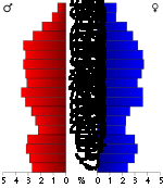
of 2000, there were 24,046 people, 10,190 households, and 7,408 families residing in the county. The population density
was 44 people per square mile (17/km²). There were 13,732 housing units at an average density of 25 per square mile (10/km²). The racial makeup of the county was 98.20% White
, 0.12% Black
or African American
, 0.47% Native American
, 0.15% Asian
, 0.02% Pacific Islander
, 0.15% from other races
, and 0.89% from two or more races. 1.17% of the population were Hispanic
or Latino
of any race.
There were 10,190 households out of which 26.30% had children under the age of 18 living with them, 61.70% were married couples
living together, 7.90% had a female householder with no husband present, and 27.30% were non-families. 24.40% of all households were made up of individuals and 12.30% had someone living alone who was 65 years of age or older. The average household size was 2.33 and the average family size was 2.74.
In the county the population was spread out with 21.30% under the age of 18, 6.60% from 18 to 24, 24.10% from 25 to 44, 26.90% from 45 to 64, and 21.10% who were 65 years of age or older. The median age was 44 years. For every 100 females there were 93.90 males. For every 100 females age 18 and over, there were 92.50 males.
The median income for a household in the county was $31,531, and the median income for a family was $37,273. Males had a median income of $28,844 versus $19,672 for females. The per capita income
for the county was $17,250. About 9.00% of families and 13.10% of the population were below the poverty line, including 17.10% of those under age 18 and 11.90% of those age 65 or over.
County (United States)
In the United States, a county is a geographic subdivision of a state , usually assigned some governmental authority. The term "county" is used in 48 of the 50 states; Louisiana is divided into parishes and Alaska into boroughs. Parishes and boroughs are called "county-equivalents" by the U.S...
located in the U.S. state
U.S. state
A U.S. state is any one of the 50 federated states of the United States of America that share sovereignty with the federal government. Because of this shared sovereignty, an American is a citizen both of the federal entity and of his or her state of domicile. Four states use the official title of...
of Arkansas
Arkansas
Arkansas is a state located in the southern region of the United States. Its name is an Algonquian name of the Quapaw Indians. Arkansas shares borders with six states , and its eastern border is largely defined by the Mississippi River...
. As of 2010, the population was 25,970. The county seat and most populous city in the county is Heber Springs
Heber Springs, Arkansas
Heber Springs is a city in Cleburne County, Arkansas, United States. The population was 6,432 at the 2000 census. The city is the county seat of Cleburne County.-Geography:Heber Springs is located at ....
, while the largest city by area is Greers Ferry
Greers Ferry, Arkansas
Greers Ferry is a city in Cleburne County, Arkansas, United States. The population was 930 at the 2000 census.-Geography:Greers Ferry is located at ....
. Cleburne County was formed on February 20, 1883, and named for Confederate
Confederate States of America
The Confederate States of America was a government set up from 1861 to 1865 by 11 Southern slave states of the United States of America that had declared their secession from the U.S...
General Patrick Cleburne
Patrick Cleburne
Patrick Ronayne Cleburne was an Irish American soldier, best known for his service in the Confederate States Army during the American Civil War, where he rose to the rank of major general....
. It is also the last of Arkansas's 75 counties to be formed. Cleburne is an alcohol prohibition or dry county
Dry county
A dry county is a county in the United States whose government forbids the sale of alcoholic beverages. Some prohibit off-premises sale, some prohibit on-premises sale, and some prohibit both. Hundreds of dry counties exist across the United States, almost all of them in the South...
.
Geography
According to the 2000 census, the county has a total area of 591.91 square miles (1,533 km²), of which 553.05 square miles (1,432.4 km²) (or 93.43%) is land and 38.86 square miles (100.6 km²) (or 6.57%) is water. Much of the water area in the County includes Greers Ferry Lake, which extends westward into neighboring Van Buren County.Major highways
|
 Arkansas Highway 124 Arkansas Highway 124Arkansas Highway 124 Arkansas Highway 124 is a designation for two state highways in Central Arkansas. The western segment of runs from Russellville to Rose Bud. An eastern segment of runs east in White County from Pangburn to AR 157.-Russellville to Rose Bud:... Arkansas Highway 210 Arkansas Highway 210 is a designation for two east–west state highways in Cleburne County, Arkansas. One segment of runs in Heber Springs from Greers Ferry Lake east to Heber Springs Road as Case Ford Road...  Arkansas Highway 225 Arkansas Highway 225 Arkansas Highway 263 Arkansas Highway 263Arkansas Highway 263 Arkansas Highway 263 is a state highway that runs in Cleburne, Stone, and Baxter Counties. It runs from Brownsville to Big Flat.-Route description:... Arkansas Highway 336 Arkansas Highway 336 is the name of multiple state highways in the Greers Ferry Lake area.-Section 1:Arkansas Highway 336 is a north–south state highway of in Van Buren County. The route runs northeast from AR 9 at Formosa to US 65/AR 9 in Clinton... Arkansas Highway 337 Arkansas Highway 337 is the name of multiple state highways in Arkansas near Greers Ferry Lake.-Section 1:Arkansas Highway 337 is a state highway of in Cleburne County... Arkansas Highway 356 Arkansas Highway 356 is an east–west state highway in north-central Arkansas. The route of runs from Highway 92 near Bee Branch east to Highway 25 and Highway 124 in Quitman.-Route description:... .svg.png) Arkansas Highway 980 Arkansas Highway 980Arkansas Highway 980 Arkansas Highway 980 is a state highway designation for all state maintained airport roads in Arkansas.-Section 1:Arkansas Highway 980 is a state highway of in Arkansas County. It connects Arkansas Highway 130 with Almyra Municipal Airport in Almyra.... |
 Arkansas Highway 5
 Arkansas Highway 16
 Arkansas Highway 25
 Arkansas Highway 25 Spur
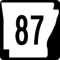 Arkansas Highway 87


Adjacent counties
- Stone County (north)
- Independence County (northeast)
- White CountyWhite County, ArkansasWhite County is a county located in the U.S. state of Arkansas. As of 2010, the population was 77,076. The county seat is Searcy. White County is Arkansas's 31st county, formed on October 23, 1835, from portions of Independence, Jackson, and Pulaski counties and named for Hugh Lawson White, a...
(southeast) - Faulkner County (southwest)
- Van Buren County (west)
Demographics
Census
A census is the procedure of systematically acquiring and recording information about the members of a given population. It is a regularly occurring and official count of a particular population. The term is used mostly in connection with national population and housing censuses; other common...
of 2000, there were 24,046 people, 10,190 households, and 7,408 families residing in the county. The population density
Population density
Population density is a measurement of population per unit area or unit volume. It is frequently applied to living organisms, and particularly to humans...
was 44 people per square mile (17/km²). There were 13,732 housing units at an average density of 25 per square mile (10/km²). The racial makeup of the county was 98.20% White
Race (United States Census)
Race and ethnicity in the United States Census, as defined by the Federal Office of Management and Budget and the United States Census Bureau, are self-identification data items in which residents choose the race or races with which they most closely identify, and indicate whether or not they are...
, 0.12% Black
Race (United States Census)
Race and ethnicity in the United States Census, as defined by the Federal Office of Management and Budget and the United States Census Bureau, are self-identification data items in which residents choose the race or races with which they most closely identify, and indicate whether or not they are...
or African American
Race (United States Census)
Race and ethnicity in the United States Census, as defined by the Federal Office of Management and Budget and the United States Census Bureau, are self-identification data items in which residents choose the race or races with which they most closely identify, and indicate whether or not they are...
, 0.47% Native American
Race (United States Census)
Race and ethnicity in the United States Census, as defined by the Federal Office of Management and Budget and the United States Census Bureau, are self-identification data items in which residents choose the race or races with which they most closely identify, and indicate whether or not they are...
, 0.15% Asian
Race (United States Census)
Race and ethnicity in the United States Census, as defined by the Federal Office of Management and Budget and the United States Census Bureau, are self-identification data items in which residents choose the race or races with which they most closely identify, and indicate whether or not they are...
, 0.02% Pacific Islander
Race (United States Census)
Race and ethnicity in the United States Census, as defined by the Federal Office of Management and Budget and the United States Census Bureau, are self-identification data items in which residents choose the race or races with which they most closely identify, and indicate whether or not they are...
, 0.15% from other races
Race (United States Census)
Race and ethnicity in the United States Census, as defined by the Federal Office of Management and Budget and the United States Census Bureau, are self-identification data items in which residents choose the race or races with which they most closely identify, and indicate whether or not they are...
, and 0.89% from two or more races. 1.17% of the population were Hispanic
Race (United States Census)
Race and ethnicity in the United States Census, as defined by the Federal Office of Management and Budget and the United States Census Bureau, are self-identification data items in which residents choose the race or races with which they most closely identify, and indicate whether or not they are...
or Latino
Race (United States Census)
Race and ethnicity in the United States Census, as defined by the Federal Office of Management and Budget and the United States Census Bureau, are self-identification data items in which residents choose the race or races with which they most closely identify, and indicate whether or not they are...
of any race.
There were 10,190 households out of which 26.30% had children under the age of 18 living with them, 61.70% were married couples
Marriage
Marriage is a social union or legal contract between people that creates kinship. It is an institution in which interpersonal relationships, usually intimate and sexual, are acknowledged in a variety of ways, depending on the culture or subculture in which it is found...
living together, 7.90% had a female householder with no husband present, and 27.30% were non-families. 24.40% of all households were made up of individuals and 12.30% had someone living alone who was 65 years of age or older. The average household size was 2.33 and the average family size was 2.74.
In the county the population was spread out with 21.30% under the age of 18, 6.60% from 18 to 24, 24.10% from 25 to 44, 26.90% from 45 to 64, and 21.10% who were 65 years of age or older. The median age was 44 years. For every 100 females there were 93.90 males. For every 100 females age 18 and over, there were 92.50 males.
The median income for a household in the county was $31,531, and the median income for a family was $37,273. Males had a median income of $28,844 versus $19,672 for females. The per capita income
Per capita income
Per capita income or income per person is a measure of mean income within an economic aggregate, such as a country or city. It is calculated by taking a measure of all sources of income in the aggregate and dividing it by the total population...
for the county was $17,250. About 9.00% of families and 13.10% of the population were below the poverty line, including 17.10% of those under age 18 and 11.90% of those age 65 or over.
Cities and towns
- ConcordConcord, ArkansasConcord is a town in Cleburne County, Arkansas, United States. The population was 255 at the 2000 census.-Geography:Concord is located at ....
- Fairfield BayFairfield Bay, ArkansasFairfield Bay is a city in Cleburne and Van Buren counties in the northern part of the U.S. state of Arkansas. The population was 2,460 at the 2000 census...
- DrascoDrasco, ArkansasDrasco is an unincorporated community in Cleburne County, Arkansas, with a ZIP code of 72530. Drasco lies just northeast of Greers Ferry Lake and includes the community of Tannenbaum. Drasco has a small food mart, a couple of restaurants, and a local hardware store.- References :...
- Greers FerryGreers Ferry, ArkansasGreers Ferry is a city in Cleburne County, Arkansas, United States. The population was 930 at the 2000 census.-Geography:Greers Ferry is located at ....
- Heber SpringsHeber Springs, ArkansasHeber Springs is a city in Cleburne County, Arkansas, United States. The population was 6,432 at the 2000 census. The city is the county seat of Cleburne County.-Geography:Heber Springs is located at ....
- HigdenHigden, ArkansasHigden is a town in Cleburne County, Arkansas, United States. The population was 101 at the 2000 census.-Geography:Higden is located at ....
- QuitmanQuitman, ArkansasQuitman is a city in Cleburne and Faulkner counties in the U.S. state of Arkansas. Its population was 714 at the 2000 census. Due to its partial location in Faulkner County, it is part of the Little Rock–North Little Rock–Conway Metropolitan Statistical Area.-Geography:Quitman is...
Townships
- California
- Center Post
- Clayton
- East Peter Creek
- Francis
- Giles (Greers FerryGreers Ferry, ArkansasGreers Ferry is a city in Cleburne County, Arkansas, United States. The population was 930 at the 2000 census.-Geography:Greers Ferry is located at ....
) - Grassey (ConcordConcord, ArkansasConcord is a town in Cleburne County, Arkansas, United States. The population was 255 at the 2000 census.-Geography:Concord is located at ....
) - Heaing Springs
- Heber (most of Heber SpringsHeber Springs, ArkansasHeber Springs is a city in Cleburne County, Arkansas, United States. The population was 6,432 at the 2000 census. The city is the county seat of Cleburne County.-Geography:Heber Springs is located at ....
) - McJester
- Morgan (part of Fairfield BayFairfield Bay, ArkansasFairfield Bay is a city in Cleburne and Van Buren counties in the northern part of the U.S. state of Arkansas. The population was 2,460 at the 2000 census...
) - Mountain
- North Cadron (part of QuitmanQuitman, ArkansasQuitman is a city in Cleburne and Faulkner counties in the U.S. state of Arkansas. Its population was 714 at the 2000 census. Due to its partial location in Faulkner County, it is part of the Little Rock–North Little Rock–Conway Metropolitan Statistical Area.-Geography:Quitman is...
) - Pickens
- Pine
- Piney
- Poff
- Saline (HigdenHigden, ArkansasHigden is a town in Cleburne County, Arkansas, United States. The population was 101 at the 2000 census.-Geography:Higden is located at ....
) - South Cadron (part of QuitmanQuitman, ArkansasQuitman is a city in Cleburne and Faulkner counties in the U.S. state of Arkansas. Its population was 714 at the 2000 census. Due to its partial location in Faulkner County, it is part of the Little Rock–North Little Rock–Conway Metropolitan Statistical Area.-Geography:Quitman is...
) - Sugar Camp
- Sugar Loaf
- Valley (part of Heber SpringsHeber Springs, ArkansasHeber Springs is a city in Cleburne County, Arkansas, United States. The population was 6,432 at the 2000 census. The city is the county seat of Cleburne County.-Geography:Heber Springs is located at ....
) - West Peter Creek (Tumbling ShoalsTumbling Shoals, ArkansasTumbling Shoals is a census-designated place in Cleburne County, Arkansas, United States. Its population was 978 as of the 2010 census....
) - Wilburn