

Karakoram Highway
Encyclopedia
The Karakoram Highway (KKH) ( śāharāha karākaram; Kèlǎkūnlún gōnglù) is the highest paved international road in the world, but at its peak at the China-Pakistan border it is only paved on the Chinese side. It connects China
and Pakistan
across the Karakoram
mountain range, through the Khunjerab Pass
, at an altitude of 4693 m (15,397 ft) as confirmed by both SRTM and multiple GPS readings. It connects China's Xinjiang
region with Pakistan's Gilgit-Baltistan and also serves as a popular tourist attraction
. Due to its high elevation and the difficult conditions in which it was constructed, it is also referred to as the "Ninth Wonder of the World."
The Karakorum Highway is known informally as the KKH, and — within Pakistan — officially as the N-35; within China, officially as China National Highway 314 (G314).
 The Karakoram Highway, also known as the Friendship Highway in China, was built by the governments of Pakistan and China, it was started in 1959 and was completed in 1979(open to the public since 1986) about 810 Pakistanis and about 200 Chinese workers lost their lives, mostly in landslides and falls, while building the highway. The route of the KKH traces one of the many paths of the ancient Silk Road
.
On the Pakistani side, the road was constructed by FWO (Frontier Works Organisation), employing the Pakistan Army Corps of Engineers. Presently, the Engineer-in-Chief' Branch of the Pakistani Army is working on a project documenting the history of the highway. A book 'History of Karakoram Highway' has been written by Brigadier (Retired) Muhammad Mumtaz Khalid. It is in two volumes. In the first volume the author discusses the land and the people, the pre-historic communication system in the Northern Areas, the need for having an all weather road link with Gilgit and the construction of Indus Valley Road. The second volume records events leading to conversion of Indus Valley Road to Karakoram Highway, the difficulties in its construction and the role of Pakistan Army Corps of Engineers and the Chinese counterparts in its construction.\
A documentary on Karakoram Highway "High Road to Hunza" by Waqar Ahmed Malik was on aired on Express News Television. The documentary is about the history and importance of this route.
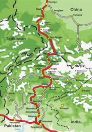
, runs approximately 1300 km (807.8 mi) from Kashgar
, a city in the Xinjiang
region of China, to Abbottabad
, of Pakistan. An extension of the highway south west from Abbottabad, in the form of N-35, meets the Grand Trunk Road, N-5 at Hassanabdal, Pakistan.
The highway cuts through the collision zone between the Eurasian
and Indian plates, where China
, Tajikistan
, Afghanistan
and Pakistan
come within 250 km of each other. Owing largely to the extremely sensitive state of the Kashmir
conflict between India and Pakistan, the Karakoram highway has strategic and military importance.
On June 30, 2006, a memorandum of understanding
was signed between the Pakistani Highway Administration and China's State-owned Assets Supervision and Administration Commission (SASAC) to rebuild and upgrade the Karakoram Highway. According to SASAC, the width of the highway will be expanded from 10 metres to 30 metres, and its transport capacity will be increased three times. As well, the upgraded road will be constructed to particularly accommodate heavy-laden vehicles and extreme weather conditions.
China and Pakistan are also planning to link the Karakoram Highway to the southern port of Gwadar
in Balochistan
through the Chinese-aided Gwadar
-Dalbandin
railway, which extends up to Rawalpindi
.
(though N-35 of which KKH is now a part, officially starts from Hassanabdal). The highway meets the Indus River
at Thakot
, and continues along the river until Bunji, where the Gilgit River
joins the Indus River
. This is the place where three great mountain ranges meet, the Hindukush, the Himalaya and the Karakoram
. The western end of the Himalayas, marked by the 9th highest peak in the world, Nanga Parbat
can be seen from the highway. The highway passes through the capital of the Gilgit-Baltistan, Gilgit
, and continues to the beautiful valleys of Nagar
and Hunza
, along the Hunza River
. Some of the highest mountains and famous glaciers in the Karakoram
can be seen from the highway in this section. Finally, the highway meets the Pakistan-China border at Khunjerab Pass
.
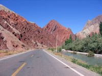 The Chinese Section of the Karakoram Highway follows the north-south Sarykol ('Yellow Lake') valley just west of the Tarim Basin
, which is barely visible in the satellite image at left. The road from Kashgar goes southwest about 80 km and then turns west to enter the Gez (Ghez) River canyon between Chakragil
mountain on the north and Kongur mountain on the south. From the Gez canyon the population becomes Kirgiz. Having climbed up to the valley, the road turns south past Kongur, Karakul Lake
and Muztagh Ata
on the east. Below Muztagh Ata a new road goes west over the Kulma Pass
to join the Pamir Highway
in Gorno-Badakhshan, Tajikistan. The main road continues over a low pass (where the population becomes Tajik) and descends to Tashkurgan. Further south a valley and jeep track leads west towards the Wakhjir Pass
to the Wakhan Corridor
. Next the road turns west to a checkpost and small settlement at Pirali, and then the Khunjerab Pass
, beyond which is Pakistan, the Khunjerab River and Hunza
.
(In 747 Gao Xianzhi
, a Tang general crossed the Broghol
Pass into what is now Pakistan - the furthest Chinese penetration in this direction. He was later defeated at the Battle of Talas
, and the Chinese withdrew from the region.)
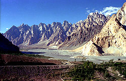
. The road has given mountaineers and cyclists easier access to the many high mountains, glaciers and lakes in the area. The highway provides access to Gilgit
and Skardu
from Islamabad
by road. These are the two major hubs for mountaineering expeditions in the Gilgit-Baltistan region of Pakistan-administered Kashmir.
The Gilgit-Baltistan Administration of Pakistan and the Xinjiang Administration of China have signed an agreement to issue border passes to their permanent residents. This pass is valid for a calendar year and is used to travel through Khunjerab Pass only.
 Karakoram Highway provides the pathway to expeditions for almost all peaks in Gilgit-Baltistan, Kashmir and several peaks in Xinjiang
China
. The region includes some of the world's largest glaciers like the Baltoro Glacier
. Five of the Eight-thousander
s (mountains taller than 8,000m) of the world that are in Pakistan
are accessible by the highway. The notable mountains that can be directly seen while traveling on the highway are:
Many glaciers can be seen while traveling on the highway:
s all along the highway that are concentrated at ten major sites between Hunza
and Shatial. The carvings were left by various invaders, traders and pilgrims
who passed along the trade route, as well as by locals. The earliest date back to between 5000 BC and 1000 BC, showing single animals, triangular men and hunting scenes in which the animals are larger than the hunters. These carvings
were pecked into the rock with stone tools and are covered with a thick patina
that yields their age.
 There are several transport companies in Pakistan that offer bus service between major towns of the highway, and from Rawalpindi
and Lahore
. The largest company is Northern Areas Transport Corporation
(NATCO). Other companies are Masherbrum Travel and Silk Route Travel.
, Gilgit-Baltistan and Kashghar, Xinjiang
, through the Sust
and Tashkorgan border area.
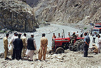
rains, around July and August, cause occasional landslides that can block the road for hours or more. The border crossing between China
and Pakistan
at Khunjerab Pass
is open only between May 1 and December 31 of every year.
Since 2 p.m. January 4, 2010, the KKH has been closed in the Hunza Valley
, eliminating through traffic to China except by small boat. A massive landslide
15 km upstream from Hunza's capital of Karimabad
created the potentially unstable Attabad Lake
which reached 22 km in length and over 100 meters in depth by the first week of June 2010 when it finally began flowing over the landslide dam. The lake displaced thousands and inundated over 20 km of the KKH including the 310 m long KKH bridge 4 km south of Gulmit
. The damage is expected to take up to two years to repair.
People's Republic of China
China , officially the People's Republic of China , is the most populous country in the world, with over 1.3 billion citizens. Located in East Asia, the country covers approximately 9.6 million square kilometres...
and Pakistan
Pakistan
Pakistan , officially the Islamic Republic of Pakistan is a sovereign state in South Asia. It has a coastline along the Arabian Sea and the Gulf of Oman in the south and is bordered by Afghanistan and Iran in the west, India in the east and China in the far northeast. In the north, Tajikistan...
across the Karakoram
Karakoram
The Karakoram, or Karakorum , is a large mountain range spanning the borders between Pakistan, India and China, located in the regions of Gilgit-Baltistan , Ladakh , and Xinjiang region,...
mountain range, through the Khunjerab Pass
Khunjerab Pass
Khunjerab Pass is a high mountain pass in the Karakoram Mountains in a strategic position on the northern border of Pakistan's Gilgit-Baltistan region within the disputed region of Kashmir and on the southwest border of the Xinjiang region of China...
, at an altitude of 4693 m (15,397 ft) as confirmed by both SRTM and multiple GPS readings. It connects China's Xinjiang
Xinjiang
Xinjiang is an autonomous region of the People's Republic of China. It is the largest Chinese administrative division and spans over 1.6 million km2...
region with Pakistan's Gilgit-Baltistan and also serves as a popular tourist attraction
Tourist attraction
A tourist attraction is a place of interest where tourists visit, typically for its inherent or exhibited cultural value, historical significance, natural or built beauty, or amusement opportunities....
. Due to its high elevation and the difficult conditions in which it was constructed, it is also referred to as the "Ninth Wonder of the World."
The Karakorum Highway is known informally as the KKH, and — within Pakistan — officially as the N-35; within China, officially as China National Highway 314 (G314).
History
Silk Road
The Silk Road or Silk Route refers to a historical network of interlinking trade routes across the Afro-Eurasian landmass that connected East, South, and Western Asia with the Mediterranean and European world, as well as parts of North and East Africa...
.
On the Pakistani side, the road was constructed by FWO (Frontier Works Organisation), employing the Pakistan Army Corps of Engineers. Presently, the Engineer-in-Chief' Branch of the Pakistani Army is working on a project documenting the history of the highway. A book 'History of Karakoram Highway' has been written by Brigadier (Retired) Muhammad Mumtaz Khalid. It is in two volumes. In the first volume the author discusses the land and the people, the pre-historic communication system in the Northern Areas, the need for having an all weather road link with Gilgit and the construction of Indus Valley Road. The second volume records events leading to conversion of Indus Valley Road to Karakoram Highway, the difficulties in its construction and the role of Pakistan Army Corps of Engineers and the Chinese counterparts in its construction.\
A documentary on Karakoram Highway "High Road to Hunza" by Waqar Ahmed Malik was on aired on Express News Television. The documentary is about the history and importance of this route.
The Highway
The highway, connecting Gilgit-Baltistan of Pakistan- controlled Kashmir to the ancient Silk RoadSilk Road
The Silk Road or Silk Route refers to a historical network of interlinking trade routes across the Afro-Eurasian landmass that connected East, South, and Western Asia with the Mediterranean and European world, as well as parts of North and East Africa...
, runs approximately 1300 km (807.8 mi) from Kashgar
Kashgar
Kashgar or Kashi is an oasis city with approximately 350,000 residents in the western part of the Xinjiang Uyghur Autonomous Region of the People's Republic of China. Kashgar is the administrative centre of Kashgar Prefecture which has an area of 162,000 km² and a population of approximately...
, a city in the Xinjiang
Xinjiang
Xinjiang is an autonomous region of the People's Republic of China. It is the largest Chinese administrative division and spans over 1.6 million km2...
region of China, to Abbottabad
Abbottabad
Abbottabad is a city located in the Hazara region of the Khyber Pakhtunkhwa province, in Pakistan. The city is situated in the Orash Valley, northeast of the capital Islamabad and east of Peshawar at an altitude of and is the capital of the Abbottabad District...
, of Pakistan. An extension of the highway south west from Abbottabad, in the form of N-35, meets the Grand Trunk Road, N-5 at Hassanabdal, Pakistan.
The highway cuts through the collision zone between the Eurasian
Eurasian Plate
The Eurasian Plate is a tectonic plate which includes most of the continent of Eurasia , with the notable exceptions of the Indian subcontinent, the Arabian subcontinent, and the area east of the Chersky Range in East Siberia...
and Indian plates, where China
China
Chinese civilization may refer to:* China for more general discussion of the country.* Chinese culture* Greater China, the transnational community of ethnic Chinese.* History of China* Sinosphere, the area historically affected by Chinese culture...
, Tajikistan
Tajikistan
Tajikistan , officially the Republic of Tajikistan , is a mountainous landlocked country in Central Asia. Afghanistan borders it to the south, Uzbekistan to the west, Kyrgyzstan to the north, and China to the east....
, Afghanistan
Afghanistan
Afghanistan , officially the Islamic Republic of Afghanistan, is a landlocked country located in the centre of Asia, forming South Asia, Central Asia and the Middle East. With a population of about 29 million, it has an area of , making it the 42nd most populous and 41st largest nation in the world...
and Pakistan
Pakistan
Pakistan , officially the Islamic Republic of Pakistan is a sovereign state in South Asia. It has a coastline along the Arabian Sea and the Gulf of Oman in the south and is bordered by Afghanistan and Iran in the west, India in the east and China in the far northeast. In the north, Tajikistan...
come within 250 km of each other. Owing largely to the extremely sensitive state of the Kashmir
Kashmir
Kashmir is the northwestern region of the Indian subcontinent. Until the mid-19th century, the term Kashmir geographically denoted only the valley between the Great Himalayas and the Pir Panjal mountain range...
conflict between India and Pakistan, the Karakoram highway has strategic and military importance.
On June 30, 2006, a memorandum of understanding
Memorandum of understanding
A memorandum of understanding is a document describing a bilateral or multilateral agreement between parties. It expresses a convergence of will between the parties, indicating an intended common line of action. It is often used in cases where parties either do not imply a legal commitment or in...
was signed between the Pakistani Highway Administration and China's State-owned Assets Supervision and Administration Commission (SASAC) to rebuild and upgrade the Karakoram Highway. According to SASAC, the width of the highway will be expanded from 10 metres to 30 metres, and its transport capacity will be increased three times. As well, the upgraded road will be constructed to particularly accommodate heavy-laden vehicles and extreme weather conditions.
China and Pakistan are also planning to link the Karakoram Highway to the southern port of Gwadar
Gwadar port
Gwadar Port is a developing warm-water, deep-sea port situated at Gwadar in Balochistan province of Pakistan at the apex of the Arabian Sea and at the entrance of the Persian Gulf, about 460 km west of Karachi and approximately east of Pakistan's border with Iran...
in Balochistan
Balochistan (Pakistan)
Balochistan is one of the four provinces or federating units of Pakistan. With an area of 134,051 mi2 or , it is the largest province of Pakistan, constituting approximately 44% of the total land mass of Pakistan. According to the 1998 population census, Balochistan had a population of...
through the Chinese-aided Gwadar
Gwadar
Gwadar also known as Godar is a developing port city on the southwestern Arabian Sea coast of Pakistan. It is the district headquarters of Gwadar District in Balochistan province and has a population of approximately 50,000.Gwadar is strategically located at the apex of the Arabian Sea and at the...
-Dalbandin
Dalbandin
Dalbandin is a town and Union council of Balochistan, Pakistan. Dalbandin is famous for fruit orchards.On 19th January, 2011, it was struck by a 7.2 magnitude earthquake. At that time it was a sparsely populated area with a population of 15,000. It is located at 28°52'60N 64°25'0E at an altitude...
railway, which extends up to Rawalpindi
Rawalpindi
Rawalpindi , locally known as Pindi, is a city in the Pothohar region of Pakistan near Pakistan's capital city of Islamabad, in the province of Punjab. Rawalpindi is the fourth largest city in Pakistan after Karachi, Lahore and Faisalabad...
.
Pakistani Section
The Pakistani section of the highway is 806 km long. It starts from AbbottabadAbbottabad
Abbottabad is a city located in the Hazara region of the Khyber Pakhtunkhwa province, in Pakistan. The city is situated in the Orash Valley, northeast of the capital Islamabad and east of Peshawar at an altitude of and is the capital of the Abbottabad District...
(though N-35 of which KKH is now a part, officially starts from Hassanabdal). The highway meets the Indus River
Indus River
The Indus River is a major river which flows through Pakistan. It also has courses through China and India.Originating in the Tibetan plateau of western China in the vicinity of Lake Mansarovar in Tibet Autonomous Region, the river runs a course through the Ladakh district of Jammu and Kashmir and...
at Thakot
Thakot
Thakot is a tribal town on the Indus River in Battagram District of Khyber Pakhtunkhwa, Pakistan. It is also one of twenty Union Councils of Battagram District, and one of twelve in Battagram Tehsil. It is located at 34°45'0N 72°55'0E at an altitude of 1131 m ,Most of the people living here...
, and continues along the river until Bunji, where the Gilgit River
Gilgit River
Gilgit River is a tributary of the Indus River, and flows past the town of Gilgit. It is located in the Northern Areas of Gilgit-Baltistan, Pakistan. The Gilgit starts from Shandur lake. The Gilgit River is also referred to as the Ghizar River....
joins the Indus River
Indus River
The Indus River is a major river which flows through Pakistan. It also has courses through China and India.Originating in the Tibetan plateau of western China in the vicinity of Lake Mansarovar in Tibet Autonomous Region, the river runs a course through the Ladakh district of Jammu and Kashmir and...
. This is the place where three great mountain ranges meet, the Hindukush, the Himalaya and the Karakoram
Karakoram
The Karakoram, or Karakorum , is a large mountain range spanning the borders between Pakistan, India and China, located in the regions of Gilgit-Baltistan , Ladakh , and Xinjiang region,...
. The western end of the Himalayas, marked by the 9th highest peak in the world, Nanga Parbat
Nanga Parbat
Nanga Parbat is the ninth highest mountain on Earth, the second highest mountain in Pakistan and among the eight-thousanders with a summit elevation of 8,126 meters...
can be seen from the highway. The highway passes through the capital of the Gilgit-Baltistan, Gilgit
Gilgit
Gilgit is a city in northern PakistanGilgit may refer to other terms related with the area of the city:* Gilgit River* Gilgit Valley* Gilgit District* Gilgit Agency * Gilgit Airport...
, and continues to the beautiful valleys of Nagar
Nagar Valley
The Nagar Valley is a valley near Gilgit Valley in the Gilgit Baltistan of Pakistan. The valley is part of Hunza Nagar District and is administratively subdivided into two tehsils namely Nagar-1 and Nagar-2. The valley is situated at an elevation of 2,438m . Nagar Khas is the main town and the...
and Hunza
Hunza Valley
The Hunza Valley is a mountainous valley in the Gilgit-Baltistan region of Pakistan. The Hunza valley is situated to the north of the Hunza River, at an elevation of around . The territory of Hunza is about...
, along the Hunza River
Hunza River
Hunza River is the principal river of Hunza, in the Northern Areas of Pakistan. It is formed by the confluence of the Kilik and Khunjerab nalas which are fed by glaciers. It is joined by the Gilgit River and the Naltar River before it flows into the Indus River.The river cuts through the...
. Some of the highest mountains and famous glaciers in the Karakoram
Karakoram
The Karakoram, or Karakorum , is a large mountain range spanning the borders between Pakistan, India and China, located in the regions of Gilgit-Baltistan , Ladakh , and Xinjiang region,...
can be seen from the highway in this section. Finally, the highway meets the Pakistan-China border at Khunjerab Pass
Khunjerab Pass
Khunjerab Pass is a high mountain pass in the Karakoram Mountains in a strategic position on the northern border of Pakistan's Gilgit-Baltistan region within the disputed region of Kashmir and on the southwest border of the Xinjiang region of China...
.
Chinese Section
Tarim Basin
The Tarim Basin is a large endorheic basin occupying an area of about . It is located in the Xinjiang Uyghur Autonomous Region in China's far west. Its northern boundary is the Tian Shan mountain range and its southern is the Kunlun Mountains on the northern edge of the Tibetan Plateau. The...
, which is barely visible in the satellite image at left. The road from Kashgar goes southwest about 80 km and then turns west to enter the Gez (Ghez) River canyon between Chakragil
Chakragil
Chakragil is a major mountain in Xinjiang, China. It is located about southwest of Kashgar, about due north of Muztagh Ata, and northwest of Kongur...
mountain on the north and Kongur mountain on the south. From the Gez canyon the population becomes Kirgiz. Having climbed up to the valley, the road turns south past Kongur, Karakul Lake
Karakul (China)
The Karakul or Karakuli is a lake located 196 km from Kashgar, Xinjiang province, China, in Akto County, Kizilsu Kirgiz Autonomous Prefecture on the Karakoram Highway, before reaching Tashkurgan, the Khunjerab Pass on the China - Pakistan border and Sost in Pakistan...
and Muztagh Ata
Muztagh Ata
Muztagh Ata, or Muztagata , is the second highest of the mountains which form the northern edge of the Tibetan Plateau . It is sometimes regarded as being part of the Kunlun Shan, although physically it is more closely connected to the Pamirs...
on the east. Below Muztagh Ata a new road goes west over the Kulma Pass
Kulma Pass
The Kulma Pass is a mountain pass across the Pamir Mountains on the border between the Gorno-Badakhshan Autonomous Region of Tajikistan and the Xinjiang Autonomous Region of China...
to join the Pamir Highway
Pamir Highway
The M41, known informally and more commonly as the Pamir Highway is a road traversing the Pamir Mountains through Afghanistan, Uzbekistan, Tajikistan, and Kyrgyzstan in Central Asia...
in Gorno-Badakhshan, Tajikistan. The main road continues over a low pass (where the population becomes Tajik) and descends to Tashkurgan. Further south a valley and jeep track leads west towards the Wakhjir Pass
Wakhjir Pass
The Wakhjir Pass is a mountain pass in the Hindu Kush or Pamirs at the eastern end of the Wakhan Corridor, the only pass between Afghanistan and China. It links Wakhan in Afghanistan with the Tashkurgan Tajik Autonomous County in Xinjiang, China, at an altitude of 4,923 m, but the pass is not an...
to the Wakhan Corridor
Wakhan Corridor
Wakhan Corridor is commonly used as a synonym for Wakhan, an area of far north-eastern Afghanistan which forms a land link or "corridor" between Afghanistan and China. The Corridor is a long and slender panhandle or salient, roughly long and between wide. It separates Tajikistan in the north...
. Next the road turns west to a checkpost and small settlement at Pirali, and then the Khunjerab Pass
Khunjerab Pass
Khunjerab Pass is a high mountain pass in the Karakoram Mountains in a strategic position on the northern border of Pakistan's Gilgit-Baltistan region within the disputed region of Kashmir and on the southwest border of the Xinjiang region of China...
, beyond which is Pakistan, the Khunjerab River and Hunza
Hunza Valley
The Hunza Valley is a mountainous valley in the Gilgit-Baltistan region of Pakistan. The Hunza valley is situated to the north of the Hunza River, at an elevation of around . The territory of Hunza is about...
.
(In 747 Gao Xianzhi
Gao Xianzhi
Gao Xianzhi, or Ko Sōnji, was a Tang general of Korean descent. He was known as a great commander during his lifetime. He is most well known for taking part in multiple military expeditions to conquer the Xiyu region over the infamous Pamir Mountains, all the way to the Aral Sea and the Caspian...
, a Tang general crossed the Broghol
Broghol
Broghol, also spelled Broghil, Boroghil and several other ways, is a high mountain pass that crosses the Hindu Kush and connects the Wakhan Corridor of Afghanistan with Chitral in Pakistan....
Pass into what is now Pakistan - the furthest Chinese penetration in this direction. He was later defeated at the Battle of Talas
Battle of Talas
The Battle of Talas in 751 AD was an especially notable conflict between the Arab Abbasid Caliphate and the Chinese Tang Dynasty for control not only of the Syr Darya region, but even more...
, and the Chinese withdrew from the region.)
Major Towns
- BeshamBeshamBesham is the largest town and commercial centre of the Shangla District in Khyber-Pakhtunkhwa province of Pakistan. Most of the population is pashto speaking pashtun....
- ChilasChilasChilas is a small town located in the Gilgit-Baltistan, Pakistan on the left side of river Indus. It is part of the Silk Road connected by the Karakoram Highway which links it to Islamabad in the south via Dassu, Besham, Mansehra, Abbottabad and Haripur...
- GilgitGilgitGilgit is a city in northern PakistanGilgit may refer to other terms related with the area of the city:* Gilgit River* Gilgit Valley* Gilgit District* Gilgit Agency * Gilgit Airport...
- Parri BanglaParri BanglaParri Bangla is a village 20 km from Gilgit city, Gilgit-Baltistan. Its ancient name was Pari which come to be known as Parri. The Karakoram Highway crosses Parri Bangla and also connects it to Juglot, Chilas, Mansehra, Abbottabad and Islamabad to the south. In the North it is connected to...
- Danyor
- GoroGoroGoro is a player character and Boss in the Mortal Kombat fighting game series. Goro is part of the four-armed half-human, half-dragon race, called the Shokan. He has served as a right-hand man for Shang Tsung and Shao Kahn...
- NagarNagarNagar can refer to:*-nagar, a term meaning "settlement" in Sanskrit and other Indo-Aryan languages*the Nagar Valley in northern Pakistan**Nagar, Pakistan, a town in northern Pakistan...
, - AliabadHunza ValleyThe Hunza Valley is a mountainous valley in the Gilgit-Baltistan region of Pakistan. The Hunza valley is situated to the north of the Hunza River, at an elevation of around . The territory of Hunza is about...
- GulmitGulmitGulmit is the headquarter of the Gojal Tehsil, in the upper Hunza region of the Gilgit territory in the deep in the Karakoram Mountain Range. Gulmit is a centuries-old historic town, with mountains, peaks and glaciers. It is a tourist spot and has many hotels, shops and a museum...
- PassuPassuPassu is a small village on the Karakoram Highway, beside the Hunza River, some 15 kilometers from Gulmit, the Tehsil Headquarter of Gojal in the Gilgit-Baltistan region of Pakistan, and about 150 km upriver from Gilgit. It lies very near the tongue of the Pasu Glacier, and just south of the...
- SostSOSTSclerostin is a protein that in humans is encoded by the SOST gene.-External links:*-Further reading:...
- Tashkurgan Town, ChinaChinaChinese civilization may refer to:* China for more general discussion of the country.* Chinese culture* Greater China, the transnational community of ethnic Chinese.* History of China* Sinosphere, the area historically affected by Chinese culture...
- Ghez
- UpalUpalUpal is a small town in western Xinjiang, China. -Karakoram Highway:Today Upal is on the Karakoram Highway, which follows the old Silk Road route from China to Pakistan...
- KashgarKashgarKashgar or Kashi is an oasis city with approximately 350,000 residents in the western part of the Xinjiang Uyghur Autonomous Region of the People's Republic of China. Kashgar is the administrative centre of Kashgar Prefecture which has an area of 162,000 km² and a population of approximately...
- Chinese railheadRailheadThe word railhead is a railway term with two distinct meanings, depending upon its context.Sometimes, particularly in the context of modern freight terminals, the word is used to denote a terminus of a railway line, especially if the line is not yet finished, or if the terminus interfaces with...
- gaugeRail gaugeTrack gauge or rail gauge is the distance between the inner sides of the heads of the two load bearing rails that make up a single railway line. Sixty percent of the world's railways use a standard gauge of . Wider gauges are called broad gauge; smaller gauges, narrow gauge. Break-of-gauge refers...
.
Tourism
In recent years the highway has become an adventure tourism destination. It was ranked as the 3rd best Tourist Destination in Pakistan by The GuardianThe Guardian
The Guardian, formerly known as The Manchester Guardian , is a British national daily newspaper in the Berliner format...
. The road has given mountaineers and cyclists easier access to the many high mountains, glaciers and lakes in the area. The highway provides access to Gilgit
Gilgit
Gilgit is a city in northern PakistanGilgit may refer to other terms related with the area of the city:* Gilgit River* Gilgit Valley* Gilgit District* Gilgit Agency * Gilgit Airport...
and Skardu
Skardu
Skardu , is the main town of the region Baltistan and the capital of Skardu District, one of the districts making up Pakistan's Gilgit Baltistan....
from Islamabad
Islamabad
Islamabad is the capital of Pakistan and the tenth largest city in the country. Located within the Islamabad Capital Territory , the population of the city has grown from 100,000 in 1951 to 1.7 million in 2011...
by road. These are the two major hubs for mountaineering expeditions in the Gilgit-Baltistan region of Pakistan-administered Kashmir.
The Gilgit-Baltistan Administration of Pakistan and the Xinjiang Administration of China have signed an agreement to issue border passes to their permanent residents. This pass is valid for a calendar year and is used to travel through Khunjerab Pass only.
Mountains and glaciers
Xinjiang
Xinjiang is an autonomous region of the People's Republic of China. It is the largest Chinese administrative division and spans over 1.6 million km2...
China
China
Chinese civilization may refer to:* China for more general discussion of the country.* Chinese culture* Greater China, the transnational community of ethnic Chinese.* History of China* Sinosphere, the area historically affected by Chinese culture...
. The region includes some of the world's largest glaciers like the Baltoro Glacier
Baltoro Glacier
The Baltoro Glacier, at 62 kilometers long, is one of the longest glaciers outside the polar regions. It is located in Baltistan, in the Gilgit-Baltistan region of Pakistan, and runs through part of the Karakoram mountain range. The Baltoro Muztagh lies to the north and east of the glacier, while...
. Five of the Eight-thousander
Eight-thousander
The eight-thousanders are the fourteen independent mountains on Earth that are more than high above sea level. They are all located in the Himalayan and Karakoram mountain ranges in Asia....
s (mountains taller than 8,000m) of the world that are in Pakistan
Pakistan
Pakistan , officially the Islamic Republic of Pakistan is a sovereign state in South Asia. It has a coastline along the Arabian Sea and the Gulf of Oman in the south and is bordered by Afghanistan and Iran in the west, India in the east and China in the far northeast. In the north, Tajikistan...
are accessible by the highway. The notable mountains that can be directly seen while traveling on the highway are:
- Nanga ParbatNanga ParbatNanga Parbat is the ninth highest mountain on Earth, the second highest mountain in Pakistan and among the eight-thousanders with a summit elevation of 8,126 meters...
, Gilgit-Baltistan, PakistanPakistanPakistan , officially the Islamic Republic of Pakistan is a sovereign state in South Asia. It has a coastline along the Arabian Sea and the Gulf of Oman in the south and is bordered by Afghanistan and Iran in the west, India in the east and China in the far northeast. In the north, Tajikistan...
, 9th highest of the world at 8,126m - RakaposhiRakaposhiRakaposhi , is a mountain in the Karakoram mountain range in Pakistan. It is situated in the Nagar Valley approximately 100 km north of the city of Gilgit in the Gilgit District of the Gilgit-Baltistan province of Pakistan. Rakaposhi means "Snow Covered" in the local language. Rakaposhi is...
, Gilgit-Baltistan, PakistanPakistanPakistan , officially the Islamic Republic of Pakistan is a sovereign state in South Asia. It has a coastline along the Arabian Sea and the Gulf of Oman in the south and is bordered by Afghanistan and Iran in the west, India in the east and China in the far northeast. In the north, Tajikistan...
, 27th highest of the world at 7,788m - DiranDiranDiran is a mountain in the Karakoram range in Gilgit-Baltistan, Pakistan. This pyramid shaped mountain lies to the east of Rakaposhi ....
, Gilgit-Baltistan, PakistanPakistanPakistan , officially the Islamic Republic of Pakistan is a sovereign state in South Asia. It has a coastline along the Arabian Sea and the Gulf of Oman in the south and is bordered by Afghanistan and Iran in the west, India in the east and China in the far northeast. In the north, Tajikistan...
, most dangerous mountain in PakistanPakistanPakistan , officially the Islamic Republic of Pakistan is a sovereign state in South Asia. It has a coastline along the Arabian Sea and the Gulf of Oman in the south and is bordered by Afghanistan and Iran in the west, India in the east and China in the far northeast. In the north, Tajikistan... - Shishpar, Gilgit-Baltistan, PakistanPakistanPakistan , officially the Islamic Republic of Pakistan is a sovereign state in South Asia. It has a coastline along the Arabian Sea and the Gulf of Oman in the south and is bordered by Afghanistan and Iran in the west, India in the east and China in the far northeast. In the north, Tajikistan...
- Ultar Peak, Gilgit-Baltistan, PakistanPakistanPakistan , officially the Islamic Republic of Pakistan is a sovereign state in South Asia. It has a coastline along the Arabian Sea and the Gulf of Oman in the south and is bordered by Afghanistan and Iran in the west, India in the east and China in the far northeast. In the north, Tajikistan...
- Tupopdan, Gilgit-Baltistan, PakistanPakistanPakistan , officially the Islamic Republic of Pakistan is a sovereign state in South Asia. It has a coastline along the Arabian Sea and the Gulf of Oman in the south and is bordered by Afghanistan and Iran in the west, India in the east and China in the far northeast. In the north, Tajikistan...
, also known as Cathedral Peaks near PassuPassuPassu is a small village on the Karakoram Highway, beside the Hunza River, some 15 kilometers from Gulmit, the Tehsil Headquarter of Gojal in the Gilgit-Baltistan region of Pakistan, and about 150 km upriver from Gilgit. It lies very near the tongue of the Pasu Glacier, and just south of the... - K2
Many glaciers can be seen while traveling on the highway:
- Minapin Glacier
- Passu Glacier
- Ghulkin Glacier
- Khunjerab Glacier
Rivers and lakes
Several rivers and lakes are also made accessible by the highway. These include:- Indus RiverIndus RiverThe Indus River is a major river which flows through Pakistan. It also has courses through China and India.Originating in the Tibetan plateau of western China in the vicinity of Lake Mansarovar in Tibet Autonomous Region, the river runs a course through the Ladakh district of Jammu and Kashmir and...
- Hunza RiverHunza RiverHunza River is the principal river of Hunza, in the Northern Areas of Pakistan. It is formed by the confluence of the Kilik and Khunjerab nalas which are fed by glaciers. It is joined by the Gilgit River and the Naltar River before it flows into the Indus River.The river cuts through the...
- Gilgit RiverGilgit RiverGilgit River is a tributary of the Indus River, and flows past the town of Gilgit. It is located in the Northern Areas of Gilgit-Baltistan, Pakistan. The Gilgit starts from Shandur lake. The Gilgit River is also referred to as the Ghizar River....
- Khunjerab River
- Karakul LakeKarakul (China)The Karakul or Karakuli is a lake located 196 km from Kashgar, Xinjiang province, China, in Akto County, Kizilsu Kirgiz Autonomous Prefecture on the Karakoram Highway, before reaching Tashkurgan, the Khunjerab Pass on the China - Pakistan border and Sost in Pakistan...
in XinjiangXinjiangXinjiang is an autonomous region of the People's Republic of China. It is the largest Chinese administrative division and spans over 1.6 million km2...
(ChinaChinaChinese civilization may refer to:* China for more general discussion of the country.* Chinese culture* Greater China, the transnational community of ethnic Chinese.* History of China* Sinosphere, the area historically affected by Chinese culture...
)
Rock art and petroglyphs
There are more than 50,000 pieces of rock art and petroglyphPetroglyph
Petroglyphs are pictogram and logogram images created by removing part of a rock surface by incising, picking, carving, and abrading. Outside North America, scholars often use terms such as "carving", "engraving", or other descriptions of the technique to refer to such images...
s all along the highway that are concentrated at ten major sites between Hunza
Hunza Valley
The Hunza Valley is a mountainous valley in the Gilgit-Baltistan region of Pakistan. The Hunza valley is situated to the north of the Hunza River, at an elevation of around . The territory of Hunza is about...
and Shatial. The carvings were left by various invaders, traders and pilgrims
Pilgrims
Pilgrims , or Pilgrim Fathers , is a name commonly applied to early settlers of the Plymouth Colony in present-day Plymouth, Massachusetts, United States...
who passed along the trade route, as well as by locals. The earliest date back to between 5000 BC and 1000 BC, showing single animals, triangular men and hunting scenes in which the animals are larger than the hunters. These carvings
Stone carving
Stone carving is an ancient activity where pieces of rough natural stone are shaped by the controlled removal of stone. Owing to the permanence of the material, evidence can be found that even the earliest societies indulged in some form of stone work....
were pecked into the rock with stone tools and are covered with a thick patina
Patina
Patina is a tarnish that forms on the surface of bronze and similar metals ; a sheen on wooden furniture produced by age, wear, and polishing; or any such acquired change of a surface through age and exposure...
that yields their age.
Travel
Rawalpindi
Rawalpindi , locally known as Pindi, is a city in the Pothohar region of Pakistan near Pakistan's capital city of Islamabad, in the province of Punjab. Rawalpindi is the fourth largest city in Pakistan after Karachi, Lahore and Faisalabad...
and Lahore
Lahore
Lahore is the capital of the Pakistani province of Punjab and the second largest city in the country. With a rich and fabulous history dating back to over a thousand years ago, Lahore is no doubt Pakistan's cultural capital. One of the most densely populated cities in the world, Lahore remains a...
. The largest company is Northern Areas Transport Corporation
Northern Areas Transport Corporation
Northern Areas Transport Corporation or NATCO is the largest transport company in Gilgit-Baltistan of Pakistan that provides bus and jeep service on the Karakoram Highway, throughout the Northern Areas....
(NATCO). Other companies are Masherbrum Travel and Silk Route Travel.
Bus service between Gilgit and Kashghar
On June 1, 2006, a daily bus service began between GilgitGilgit
Gilgit is a city in northern PakistanGilgit may refer to other terms related with the area of the city:* Gilgit River* Gilgit Valley* Gilgit District* Gilgit Agency * Gilgit Airport...
, Gilgit-Baltistan and Kashghar, Xinjiang
Xinjiang
Xinjiang is an autonomous region of the People's Republic of China. It is the largest Chinese administrative division and spans over 1.6 million km2...
, through the Sust
Sust
Sust or Sost is a dry port in Gojal region of the Northern Areas of Pakistan. It is the last town inside Pakistan on the Karakoram Highway before the Chinese border...
and Tashkorgan border area.
Weather
The KKH is best travelled in the spring or early autumn. Heavy snow during harsh winters can shut the highway down for extended periods. Heavy monsoonMonsoon
Monsoon is traditionally defined as a seasonal reversing wind accompanied by corresponding changes in precipitation, but is now used to describe seasonal changes in atmospheric circulation and precipitation associated with the asymmetric heating of land and sea...
rains, around July and August, cause occasional landslides that can block the road for hours or more. The border crossing between China
China
Chinese civilization may refer to:* China for more general discussion of the country.* Chinese culture* Greater China, the transnational community of ethnic Chinese.* History of China* Sinosphere, the area historically affected by Chinese culture...
and Pakistan
Pakistan
Pakistan , officially the Islamic Republic of Pakistan is a sovereign state in South Asia. It has a coastline along the Arabian Sea and the Gulf of Oman in the south and is bordered by Afghanistan and Iran in the west, India in the east and China in the far northeast. In the north, Tajikistan...
at Khunjerab Pass
Khunjerab Pass
Khunjerab Pass is a high mountain pass in the Karakoram Mountains in a strategic position on the northern border of Pakistan's Gilgit-Baltistan region within the disputed region of Kashmir and on the southwest border of the Xinjiang region of China...
is open only between May 1 and December 31 of every year.
Since 2 p.m. January 4, 2010, the KKH has been closed in the Hunza Valley
Hunza Valley
The Hunza Valley is a mountainous valley in the Gilgit-Baltistan region of Pakistan. The Hunza valley is situated to the north of the Hunza River, at an elevation of around . The territory of Hunza is about...
, eliminating through traffic to China except by small boat. A massive landslide
Landslide
A landslide or landslip is a geological phenomenon which includes a wide range of ground movement, such as rockfalls, deep failure of slopes and shallow debris flows, which can occur in offshore, coastal and onshore environments...
15 km upstream from Hunza's capital of Karimabad
Karimabad (Hunza)
Karimabad is the capital of Hunza in Gilgit-Baltistan, northern Pakistan. Karimabad is also known as Baltit. It is named after Prince Karim Aga Khan, the spiritual head of Shia Ismaili Nizari community. The Guardian ranked it as the 12th Best Tourist Site in Pakistan.-See also:*Hunza...
created the potentially unstable Attabad Lake
Attabad Lake
Attabad Lake, Gojal, also known as Gojal Lake, is a lake in the Hunza Valley of northern Pakistan created in January 2010 by a landslide dam. The lake was formed due to a massive landslide at Attabad village in Gilgit-Baltistan, upstream of Karimabad that occurred on January 4, 2010. The...
which reached 22 km in length and over 100 meters in depth by the first week of June 2010 when it finally began flowing over the landslide dam. The lake displaced thousands and inundated over 20 km of the KKH including the 310 m long KKH bridge 4 km south of Gulmit
Gulmit
Gulmit is the headquarter of the Gojal Tehsil, in the upper Hunza region of the Gilgit territory in the deep in the Karakoram Mountain Range. Gulmit is a centuries-old historic town, with mountains, peaks and glaciers. It is a tourist spot and has many hotels, shops and a museum...
. The damage is expected to take up to two years to repair.
See also
- Leh–Manali Highway
- GilgitGilgitGilgit is a city in northern PakistanGilgit may refer to other terms related with the area of the city:* Gilgit River* Gilgit Valley* Gilgit District* Gilgit Agency * Gilgit Airport...
- Hunza ValleyHunza ValleyThe Hunza Valley is a mountainous valley in the Gilgit-Baltistan region of Pakistan. The Hunza valley is situated to the north of the Hunza River, at an elevation of around . The territory of Hunza is about...
- KarakoramKarakoramThe Karakoram, or Karakorum , is a large mountain range spanning the borders between Pakistan, India and China, located in the regions of Gilgit-Baltistan , Ladakh , and Xinjiang region,...
- Kashghar
- LadakhLadakhLadakh is a region of Jammu and Kashmir, the northernmost state of the Republic of India. It lies between the Kunlun mountain range in the north and the main Great Himalayas to the south, inhabited by people of Indo-Aryan and Tibetan descent...
- National Highways of Pakistan
- Pamir HighwayPamir HighwayThe M41, known informally and more commonly as the Pamir Highway is a road traversing the Pamir Mountains through Afghanistan, Uzbekistan, Tajikistan, and Kyrgyzstan in Central Asia...
- Gilgit-Baltistan
- ShandurShandurShandur Top located in District Ghizer of Gilgit-Baltistan.Shandur-Top in Ghizer is often called the 'Roof of the World' where the Hindukush in Gilgit-Baltistan, Between Afghanistan and Gilgit-Baltistan and Karakorum mountainous ranges of Gilgit-Baltistan meet. The top is flat, a plateau and can...
- Silk RoadSilk RoadThe Silk Road or Silk Route refers to a historical network of interlinking trade routes across the Afro-Eurasian landmass that connected East, South, and Western Asia with the Mediterranean and European world, as well as parts of North and East Africa...
- SkarduSkarduSkardu , is the main town of the region Baltistan and the capital of Skardu District, one of the districts making up Pakistan's Gilgit Baltistan....
- XinjiangXinjiangXinjiang is an autonomous region of the People's Republic of China. It is the largest Chinese administrative division and spans over 1.6 million km2...
- KashmirKashmirKashmir is the northwestern region of the Indian subcontinent. Until the mid-19th century, the term Kashmir geographically denoted only the valley between the Great Himalayas and the Pir Panjal mountain range...
- Kashmir railwayKashmir RailwayThe Kashmir Railway is a railway line being built in India to connect the state of Jammu and Kashmir with the rest of the country. Officially termed the Jammu Udhampur Srinagar Baramulla Railway Link , the railway starts from Jammu and, when completed, will travel for to the city of Baramulla on...
External links
- Urdu: A documentary on Karakoram Highway 8th wonder of the world
- History of KKH by Brigadier (Retired) Mumtaz Khalid (Pakistan Army Corps of Engineers)
- Blankonthemap The Northern Kashmir WebSite
- Northern Areas Development Gateway
- Pakistan's Northern Areas
- Karakoram Highway Map
- A good brief description of the highway
- Photographic Account of Journey through KKH