
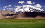
Muztagh Ata
Encyclopedia

Uyghur language
Uyghur , formerly known as Eastern Turk, is a Turkic language with 8 to 11 million speakers, spoken primarily by the Uyghur people in the Xinjiang Uyghur Autonomous Region of Western China. Significant communities of Uyghur-speakers are located in Kazakhstan and Uzbekistan, and various other...
: مۇز تاغ ئاتا, literally "ice-mountain-father"; ), is the second highest (7546 metres) of the mountains which form the northern edge of the Tibetan Plateau
Tibetan Plateau
The Tibetan Plateau , also known as the Qinghai–Tibetan Plateau is a vast, elevated plateau in Central Asia covering most of the Tibet Autonomous Region and Qinghai, in addition to smaller portions of western Sichuan, southwestern Gansu, and northern Yunnan in Western China and Ladakh in...
(not the second highest of the mountains of the Tibetan Plateau
Tibetan Plateau
The Tibetan Plateau , also known as the Qinghai–Tibetan Plateau is a vast, elevated plateau in Central Asia covering most of the Tibet Autonomous Region and Qinghai, in addition to smaller portions of western Sichuan, southwestern Gansu, and northern Yunnan in Western China and Ladakh in...
). It is sometimes regarded as being part of the Kunlun Shan, although physically it is more closely connected to the Pamirs
Pamir Mountains
The Pamir Mountains are a mountain range in Central Asia formed by the junction or knot of the Himalayas, Tian Shan, Karakoram, Kunlun, and Hindu Kush ranges. They are among the world’s highest mountains and since Victorian times they have been known as the "Roof of the World" a probable...
. It is also reputedly one of the easiest 7,000 m peaks in the world to climb, due to its gentle western slope and the comparatively drier weather of Xinjiang
Xinjiang
Xinjiang is an autonomous region of the People's Republic of China. It is the largest Chinese administrative division and spans over 1.6 million km2...
.
Location
Muztagh Ata lies just south of Kongur TaghKongur Tagh
Kongur Tagh or Kongkoerh is at 7,649 m the highest mountain wholly within the Xinjiang Uyghur Autonomous Region.-Geography:...
, the highest peak of the Kunlun Shan. Together they form a somewhat isolated group, separated from the main chain of the Kunlun, and also separate from the Pamir Mountains
Pamir Mountains
The Pamir Mountains are a mountain range in Central Asia formed by the junction or knot of the Himalayas, Tian Shan, Karakoram, Kunlun, and Hindu Kush ranges. They are among the world’s highest mountains and since Victorian times they have been known as the "Roof of the World" a probable...
to the west. (Both peaks are sometimes regarded as being in the "Chinese Pamir", and are more closely connected to the main Pamir group than the main Kunlun group.) Not far to the north and east of this group are the lowlands of the Tarim Basin
Tarim Basin
The Tarim Basin is a large endorheic basin occupying an area of about . It is located in the Xinjiang Uyghur Autonomous Region in China's far west. Its northern boundary is the Tian Shan mountain range and its southern is the Kunlun Mountains on the northern edge of the Tibetan Plateau. The...
and the Taklamakan
Taklamakan
The Taklamakan Desert , also known as Taklimakan and Teklimakan, is a desert in Central Asia, in the Xinjiang Uyghur Autonomous Region of the People's Republic of China...
Desert. The Karakoram Highway
Karakoram Highway
The Karakoram Highway is the highest paved international road in the world, but at its peak at the China-Pakistan border it is only paved on the Chinese side. It connects China and Pakistan across the Karakoram mountain range, through the Khunjerab Pass, at an altitude of as confirmed by both...
passes very close to both peaks as well as Karakul Lake
Karakul (China)
The Karakul or Karakuli is a lake located 196 km from Kashgar, Xinjiang province, China, in Akto County, Kizilsu Kirgiz Autonomous Prefecture on the Karakoram Highway, before reaching Tashkurgan, the Khunjerab Pass on the China - Pakistan border and Sost in Pakistan...
, from which the mountain is conveniently viewed. The closest city is to the mountain is Tashkurgan, the westernmost town in China and very close to the border with Pakistan
Pakistan
Pakistan , officially the Islamic Republic of Pakistan is a sovereign state in South Asia. It has a coastline along the Arabian Sea and the Gulf of Oman in the south and is bordered by Afghanistan and Iran in the west, India in the east and China in the far northeast. In the north, Tajikistan...
.
History
The SwedishSweden
Sweden , officially the Kingdom of Sweden , is a Nordic country on the Scandinavian Peninsula in Northern Europe. Sweden borders with Norway and Finland and is connected to Denmark by a bridge-tunnel across the Öresund....
explorer and geographer Sven Hedin
Sven Hedin
Sven Anders Hedin KNO1kl RVO was a Swedish geographer, topographer, explorer, photographer, and travel writer, as well as an illustrator of his own works...
made the first recorded attempt to climb Muztagh Ata, in 1894. Additional attempts were made in 1900, 1904 and 1947, the last by the team of Eric Shipton
Eric Shipton
Eric Earle Shipton CBE was a distinguished British Himalayan mountaineer.-Early years:Born in Ceylon in 1907 where his father, a tea planter, died before he was three years old. His mother buried her grief by taking Eric and his sister Marge and travelling constantly for the next five years...
and Bill Tilman
Bill Tilman
Major Harold William "Bill" Tilman, CBE, DSO, MC and Bar was an English mountaineer and explorer, renowned for his Himalayan climbs and sailing voyages.-Early years and Africa:...
who came very close to the summit but were turned back due to cold and deep snow.
The first ascent of the peak was in 1956 by a large party of Chinese
China
Chinese civilization may refer to:* China for more general discussion of the country.* Chinese culture* Greater China, the transnational community of ethnic Chinese.* History of China* Sinosphere, the area historically affected by Chinese culture...
and Russia
Russia
Russia or , officially known as both Russia and the Russian Federation , is a country in northern Eurasia. It is a federal semi-presidential republic, comprising 83 federal subjects...
n climbers, via the west ridge, which is now the standard route.
Since the first ascent, many ascents of Muztagh Ata have been made. In 1980, a party led by Ned Gillette made a ski ascent/descent of the standard route, the first ski ascent of a mountain over 7500 m (24,606.3 ft). An ascent of the much harder south-east ridge was made in 2000, and a secondary route at the west side of the mountain was first climbed in the summer of 2005.
Sources
- Jill Neate, High Asia: An Illustrated History of the 7000 Metre Peaks, ISBN 0-89886-238-8.
- Himalayan Index
External links
- Muztagh Ata on summitpost.org (Lots of information)
- Muztagh ata Information