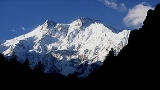
All Topics  
Nanga Parbat

 
Nanga Parbat

   Email Print
   Bookmark   Link


Nanga Parbat


Nanga Parbat (Urdu
Urdu

Urdu is a Central_Indo-Aryan_languages#Central_Zone_.28Madhya_or_Hindi.29 Indo-Aryan languages of the Indo-Iranian languages, belonging to the Indo-European languages family of languages....
: ) is the ninth highest
List of highest mountains

The following is a list of the world's 100+ highest mountains per height above sea level, all of which are located in Asia. Only those summits are included that, by an objective measure, may be considered individual mountains as opposed to subsidiary peaks....
 mountain
Mountain

A mountain is a landform that stretches above the surrounding land in a limited area usually in the form of a peak. A mountain is generally steeper than a hill....
 on Earth
Earth

Earth is the third planet from the Sun. Earth is the largest of the terrestrial planets in the Solar System in diameter, mass and density. It is also referred to as the World and Wiktionary:Terra.Note that by International Astronomical Union convention, the term "Terra" is used for naming extensive land masses, rather...
. Nanga Parbat means "Naked Mountain" in Urdu
Urdu

Urdu is a Central_Indo-Aryan_languages#Central_Zone_.28Madhya_or_Hindi.29 Indo-Aryan languages of the Indo-Iranian languages, belonging to the Indo-European languages family of languages....
, parbat deriving from the Sanskrit word parvata meaning "mountain, rock", and nanga from the Sanskrit word nagna meaning "naked, bare". Known as the "Killer Mountain," Nanga Parbat was one of the deadliest of the eight-thousander
Eight-thousander

The eight-thousanders are the fourteen independent mountains on Earth that are more than high above sea level. They are all located in the Himalayan and Karakoram mountain ranges in Asia....
s for climbers in the first half of the twentieth century; since that time it has been less so, though still an extremely serious climb.


Discussion
Ask a question about 'Nanga Parbat'
Start a new discussion about 'Nanga Parbat'
Answer questions from other users
Full Discussion Forum


Encyclopedia


Nanga Parbat (Urdu
Urdu

Urdu is a Central_Indo-Aryan_languages#Central_Zone_.28Madhya_or_Hindi.29 Indo-Aryan languages of the Indo-Iranian languages, belonging to the Indo-European languages family of languages....
: ) is the ninth highest
List of highest mountains

The following is a list of the world's 100+ highest mountains per height above sea level, all of which are located in Asia. Only those summits are included that, by an objective measure, may be considered individual mountains as opposed to subsidiary peaks....
 mountain
Mountain

A mountain is a landform that stretches above the surrounding land in a limited area usually in the form of a peak. A mountain is generally steeper than a hill....
 on Earth
Earth

Earth is the third planet from the Sun. Earth is the largest of the terrestrial planets in the Solar System in diameter, mass and density. It is also referred to as the World and Wiktionary:Terra.Note that by International Astronomical Union convention, the term "Terra" is used for naming extensive land masses, rather...
. Nanga Parbat means "Naked Mountain" in Urdu
Urdu

Urdu is a Central_Indo-Aryan_languages#Central_Zone_.28Madhya_or_Hindi.29 Indo-Aryan languages of the Indo-Iranian languages, belonging to the Indo-European languages family of languages....
, parbat deriving from the Sanskrit word parvata meaning "mountain, rock", and nanga from the Sanskrit word nagna meaning "naked, bare". Known as the "Killer Mountain," Nanga Parbat was one of the deadliest of the eight-thousander
Eight-thousander

The eight-thousanders are the fourteen independent mountains on Earth that are more than high above sea level. They are all located in the Himalayan and Karakoram mountain ranges in Asia....
s for climbers in the first half of the twentieth century; since that time it has been less so, though still an extremely serious climb. It is also an immense, dramatic peak that rises far above its surrounding terrain.

Location

Nanga Parbat is the western anchor of the Himalayas and is the westernmost eight-thousander
Eight-thousander

The eight-thousanders are the fourteen independent mountains on Earth that are more than high above sea level. They are all located in the Himalayan and Karakoram mountain ranges in Asia....
. It lies just south of the Indus River
Indus River

File:Indian subcontinent CIA.pngThe Indus River is the longest river in Pakistan and the twenty-first largest river in the world, in terms of annual flow, on the Indian Subcontinent....
 in the Astore District
Astore District

Astore is one of the six Districts of Pakistans of the Northern Areas of Pakistan. The district contains the Astore Valley and is bounded to the west by Diamer District , to the north by Gilgit District, to the east by Skardu District and to the south by North-West Frontier Province, Neelum District of Azad Kashmir and in the far southeast G...
 of the Northern Areas in Pakistan administered Kashmir. Not far to the north is the western end of the Karakoram
Karakoram

Karakoram is a large mountain range spanning the borders between Pakistan, China, and India, located in the regions of Gilgit District, Ladakh, and Baltistan....
 range.

Notable features

Nanga Parbat has tremendous vertical relief over local terrain in all directions. To the south, Nanga Parbat boasts what is often referred to as the highest mountain face in the world: the Rupal Face rises 4,600 m (15,000 feet) above its base. To the north, the complex, somewhat more gently sloped Rakhiot Flank rises 7,000 m (22,966 feet) from the Indus River valley to the summit in just 27 km, one of the 10 greatest elevation gains in so short a distance on Earth.

Approachingnangaparbat

Layout of the mountain

The core of Nanga Parbat is a long ridge trending southwest-northeast. The ridge is an enormous bulk of ice and rock. It has three faces, Diamir face, Rakhiot and Rupal. The southwestern portion of this main ridge is known as the Mazeno Wall, and has a number of subsidiary peaks. In the other direction, the main ridge arcs northeast at Rakhiot Peak (7,070 meters). The south/southeast side of the mountain is dominated by the massive Rupal Face, noted above. The north/northwest side of the mountain, leading to the Indus, is more complex. It is split into the Diamir (west) face and the Rakhiot (north) face by a long ridge. There are a number of subsidiary summits, including North Peak (7,816 m) some 3 km north of the main summit. Near the base of the Rupal Face is a beautiful glacial lake called Latbo, above a seasonal shepherds' village of the same name.

Climbing history


Early attempts

Climbing attempts started very early on Nanga Parbat. In 1895 Albert F. Mummery
Albert F. Mummery

Albert Frederick Mummery , was a United Kingdom mountaineer and author....
 led an expedition to the peak, and reached almost 7,000 m on the Diamir (West) Face, but Mummery and two Gurkha
Gurkha

Gurkha, also spelled as Gorkha, are people from Nepal and northern India who take their name from the eighth century Hindu warrior-saint Guru Gorakhnath....
 companions later died reconnoitering the Raikot Face.

In the 1930s, Nanga Parbat became the focus of German
Germany

Germany , officially the Federal Republic of Germany , is a country in Central Europe. It is bordered to the north by the North Sea, Denmark, and the Baltic Sea; to the east by Poland and the Czech Republic; to the south by Austria and Switzerland; and to the west by France, Luxembourg, Belgium, and the Netherlands....
 interest in the Himalaya. The German mountaineers were unable to attempt Mount Everest
Mount Everest

Mount Everest, also called Sagarmatha or Chomolungma, Qomolangma or Zhumulangma is the List of highest mountains on Earth, as measured by the height of its Topographical summit above sea level, which is ....
, as only the British had access to Tibet
Tibet

Tibet is a Tibetan Plateau in Asia, north of the Himalayas, and the home to the indigenous Tibetan people and its related ethnic groups. With an average elevation of 4,900 metres , it is the highest region on Earth and has in recent decades increasingly been referred to as the "Roof of the World"....
. Initially German efforts focussed on Kanchenjunga, to which Paul Bauer
Paul Bauer

Paul Bauer was a Germany poet.In 1932 he won a gold medal in the art competitions of the Olympic Games for his "Am Kangehenzonga"....
 led two expeditions in 1930 and 1931, but with its long ridges and steep faces Kanchenjunga was more difficult than Everest and neither expedition made much progress. K2
K2

K2 is the second-List of highest mountains mountain on Earth . With a peak elevation of , K2 is part of the Karakoram segment of the Himalayan mountain range, and is located on the border between Pakistan's northern territories, and the Taxkorgan Tajik Autonomous County of Xinjiang, China....
 was known to be harder still, and its remoteness meant that even reaching its base would be a major undertaking. Nanga Parbat was therefore the highest mountain accessible to Germans which they seemed to have a chance of climbing.

The first German expedition to Nanga Parbat was led by Willy Merkl in 1932. It is sometimes referred to as a German-American expedition, as the eight climbers included Rand Herron, an American, and Fritz Wiessner
Fritz Wiessner

Fritz Wiessner was a pioneer of free climbing. Born in Dresden, Germany, he emigrated to New York City in 1929. He became a U.S. citizen in 1935....
, who would become an American citizen the following year. While the team were all strong climbers, none had Himalayan experience, and poor planning (particularly an inadequate number of porters
Porter (carrier)

A porter, also called a bearer, is a person who carries objects for others....
), coupled with bad weather, prevented the team progressing far beyond the Rakhiot Peak
Rakhiot Peak

Rakhiot Peak is a peak in the Himalaya range of the Northern Areas of Pakistan.It is one of the many subsidiary summits of the core of Nanga Parbat....
, reached by Peter Aschenbrenner and Herbert Kunigk, but they did establish the feasibility of a route via Rakhiot Peak and the main ridge.

Merkl led another expedition in 1934, which was better prepared and financed with the full backing of the new Nazi government. Early in the expedition Alfred Drexel died, probably of high altitude pulmonary edema
High Altitude Pulmonary Edema

High altitude pulmonary edema is a life-threatening form of non-cardiogenic pulmonary edema that occurs in otherwise healthy mountaineers at altitudes above 2,500 meters ....
, . The Tyrol
Tyrol

Tyrol is a region in Western Central Europe, which included the present day States of Austria of Tyrol , the Regions of Italy Trentino-Alto Adige/S?dtirol and three Comunes of the Veneto Regions of Italy ....
ean climbers Peter Aschenbrenner and Erwin Schneider reached an estimated height of 7895 m on July 6, but were forced to return because of worsening weather. On July 7 they and 14 others were trapped by a ferocious storm at 7480m. During the desperate retreat that followed, three famous German mountaineers, Uli Wieland, Willo Welzenbach and Merkl himself, and six Sherpas died of exhaustion, exposure and altitude sickness, and several more suffered severe frostbite
Frostbite

Frostbite is the medical condition wherein localized damage is caused to skin and other biological tissue due to extreme cold.Frostbite is most likely to happen in body parts farthest from the heart and those with large exposed areas....
. The last survivor to reach safety, Ang Tsering, did so having spent seven days battling through the storm. It has been said that the disaster, "for sheer protracted agony, has no parallel in climbing annals."

In 1937, Karl Wien
Karl Wien

Karl Wien was a Germany mountaineer.Born in W?rzburg, Wien was the son of a university professor, and became a lecturer himself in the geography department of Munich University....
 led another expedition to the mountain, following the same route as Merkl's expeditions had done. Progress was made, but more slowly than before due to heavy snowfall. Some time around the 14th of June seven Germans and nine Sherpas, almost the entire team, were at Camp IV below Raikot Peak when it was overwhelmed by an avalanche
Avalanche

An avalanche is a rapid flow of snow down a slope, from either natural triggers or human activity. Typically occurring in mountainous terrain, an avalanche can mix air and water with the descending snow....
. All sixteen men died instantly, in what remains the worst single disaster to occur on an 8000m peak
Eight-thousander

The eight-thousanders are the fourteen independent mountains on Earth that are more than high above sea level. They are all located in the Himalayan and Karakoram mountain ranges in Asia....
.

The Germans returned in 1938 led by Paul Bauer, but the expedition was plagued by bad weather and Bauer, mindful of the previous disasters, ordered the party down before the Silver Saddle was reached. The following year a small four man expedition, including Heinrich Harrer
Heinrich Harrer

Heinrich Harrer was an Austrian mountaineer, sportsman, geographer, and author.He is best known for his books The White Spider and Seven Years in Tibet, although his pre-war Nazi links made headlines in 1997....
, explored the Diamir Face with the aim of finding an easier route. They concluded that the face was a viable route, but the Second World War intervened and the four men were interned
Internment

Internment is the imprisonment or confinement of people, commonly in large groups, without trial. The Oxford English Dictionary gives the meaning as: "The action of ?interning?; confinement within the limits of a country or place"....
 in India. Harrer's escape and subsequent travels became the subject of his book Seven Years in Tibet
Seven Years in Tibet

Seven Years in Tibet is an adventure story written by Austria mountaineer and onetime Schutzstaffel Heinrich Harrer based on his real life experiences in Tibet between 1944 and 1951 during the Second World War and the interim period before the Communist Chinese People's Liberation Army moved into Tibet in 1950....
.

First ascent


Nanga Parbat was first climbed on July 3, 1953 by Austria
Austria

Austria , officially the Republic of Austria , is a landlocked country in Central Europe. It borders both Germany and the Czech Republic to the north, Slovakia and Hungary to the east, Slovenia and Italy to the south, and Switzerland and Liechtenstein to the west....
n climber Hermann Buhl
Hermann Buhl

Hermann Buhl is considered one of the best post-World War II Austrian climbing and one of the best climbers of all time. He was particularly innovative in applying alpine style to Himalayas climbing....
, a member of a German
Germany

Germany , officially the Federal Republic of Germany , is a country in Central Europe. It is bordered to the north by the North Sea, Denmark, and the Baltic Sea; to the east by Poland and the Czech Republic; to the south by Austria and Switzerland; and to the west by France, Luxembourg, Belgium, and the Netherlands....
-Austria
Austria

Austria , officially the Republic of Austria , is a landlocked country in Central Europe. It borders both Germany and the Czech Republic to the north, Slovakia and Hungary to the east, Slovenia and Italy to the south, and Switzerland and Liechtenstein to the west....
n team. The expedition was organized by the half-brother of Willy Merkl, Karl Herrligkoffer from Munich
Munich

Munich is the capital city of Bavaria, Germany. Munich is located on the River Isar north of the Northern Limestone Alps. Munich is the third largest city in Germany, after Berlin and Hamburg....
, while the expedition leader was Peter Aschenbrenner from Innsbruck
Innsbruck

Innsbruck is the Capital of the federal state of Tyrol in western Austria. It is located in the Inn River Valley at the junction with the Wipptal , which provides access to the Brenner Pass, some 30 km south of Innsbruck....
, who had participated in the 1932 and 1934 attempts. By the time of this expedition, 31 people had already died on the mountain. The final push for the summit was dramatic: Buhl continued alone, after his companions had turned back, and arrived at 7 p.m.; the climbing being harder and more time consuming than he had anticipated. His descent was slowed when he lost a crampon, and caught by darkness he was forced to bivouac
Bivouac shelter

A bivouac traditionally refers to a military encampment made with tents or improvised shelters, usually without shelter or protection from enemy fire or such a site where a camp may be built....
 standing upright on a narrow ledge, holding a small handhold with one hand. Exhausted, he dozed occasionally, but managed to maintain his balance. He was also very fortunate to have a calm night so he was not subjected to wind chill
Wind chill

Wind chill is the Felt air temperature felt on exposed skin due to wind. The degree of this phenomenon depends on both air temperature and wind speed....
. He finally reached his high camp at 7 p.m. the next day, 40 hours after setting off. The ascent was made without oxygen, and Buhl is the only man to have made the first ascent
First ascent

In climbing, a first ascent is the first successful, documented attainment of the top of a mountain, or the first to follow a particular climbing route....
 of an 8000m peak alone.

Subsequent attempts and ascents


The second ascent of Nanga Parbat was via the Diamir Face, in 1962, by Germans Toni Kinshofer
Toni Kinshofer

Toni Kinshofer was a Germans mountain climber.In 1961, he undertook the first winter ascent of the Eiger North Face with Toni Hiebeler, Walter Almberger and Anderl Mannhardt; at 21, Kinshofer was the youngest member of the team....
, S. Löw, and A. Mannhardt. This route is now the "standard route" on the mountain. The Kinshofer route does not ascend the middle of the Diamir Face, which is threatened by avalanches from massive hanging glaciers. Instead it climbs a buttress on the left side of the face.

In 1970 Reinhold
Reinhold Messner

Reinhold Messner is an Italy mountaineer and explorer from South Tyrol, often cited as the greatest mountain climbing of all time. He is renowned for making the first solo ascents of Mount Everest without supplemental oxygen and for being the first climber to ascend all fourteen "eight-thousanders" ....
 and Günther Messner reached the summit via a direct route on the huge, difficult Rupal Face; this was the third ascent of the mountain. Their descent was epic: they were unable to descend their ascent route, and instead made the first traverse of the mountain, going down the Diamir Face. Unfortunately Günther was killed in an avalanche on the Diamir. (Messner's account of this incident was disputed, and cast a further shadow over this achievement. In 2005 Günther's remains were found on the Diamir Face.)

In 1978 Reinhold Messner returned to the Diamir Face and achieved the first completely solo ascent (i.e. always solo above Base Camp) of an 8,000m peak.

In 1984 the French climber Lilliane Barrard became the first woman to climb Nanga Parbat, along with her husband Maurice Barrard.

Among other ascents of the peak, the 1985 ascent by Jerzy Kukuczka
Jerzy Kukuczka

Jerzy Kukuczka , born in Katowice, Poland, was a Polish alpine and high-altitude climber. On 18 September 1987, he became the second man, after Reinhold Messner, to climb all fourteen eight-thousanders in the world....
 et al stands out. They climbed a bold line up the Southeast Pillar (or Polish Spur) on the right-hand side of the Rupal Face.

Recently some well-known climbers have been attempting very quick ascents of the Rupal Face. In particular, late summer of 2005 was a busy time on the face. In August, Pakistani military helicopters rescued renowned Slovenia
Slovenia

Slovenia , officially the Republic of Slovenia , is a country in southern Central Europe bordering Italy to the west, the Adriatic Sea to the southwest, Croatia to the south and east, Hungary to the northeast, and Austria to the north....
n mountaineer Tomaž Humar
Tomaž Humar

Toma? Humar is a Slovenian mountaineering. He has completed over 1500 ascents, and has won a number of mountaineering and other awards, including the Piolet d'Or in 1996 and the Silver Order of Freedom of the Republic of Slovenia in 1999....
, who was stuck under a narrow ice ledge at 5,900 metres for six days. It is believed to be one of the few successful rescues carried out at such high altitude. In September 2005, Vince Anderson
Vince Anderson

Vince Anderson is an American professional mountaineer, writer and mountain guide company manager from Ridgway, Colorado. He and Steve House won the Piolet d'Or in 2006 for an alpine-style first ascent of the Central Pillar of the Rupal Face, , September 1-8, 2005 on Nanga Parbat in northern Pakistan....
 and Steve House
Steve House

Steve House is an United States professional climber and mountain guide from La Grande, Oregon, Oregon....
 did an extremely lightweight, fast ascent of a new, direct route on the face, earning high praise from the climbing community.

On the 17th or 18th of July 2006, José Antonio Delgado Sucre, an elite high altitude climber from Venezuela, died a few days after making the summit, where he was caught by bad weather for 6 straight days and was not able to make his way down. He was the only Venezuelan climber, and one of the few Latin Americans, to have summited five eight-thousanders. Part of the expedition and the rescue efforts at base camp were captured on video as José Antonio Delgado Sucre was the subject of a pilot for a mountaineering television series . Explorart Films, the production company, later developed the project into a feature documentary film called Beyond the Summit, which is scheduled to be released theatrically in South America in January 2008 .

On July 15, 2008, Italian elite alpinist Karl Unterkircher
Karl Unterkircher

Karl Unterkircher was an Italy mountaineer. He is mostly known for opening new mountain routes. In 2004, he was the first alpinist to climb the two highest peaks on Earth without oxygen in the same year....
 fell into a crevasse during an attempt to open, with Walter Nones and Simon Kehrer, a new route to the top. Unterkircher died, but Simon Kehrer and Walter Nones were rescued by the Pakistani rescue team after many efforts.

Nearby Peaks


  • Rakhiot Peak
    Rakhiot Peak

    Rakhiot Peak is a peak in the Himalaya range of the Northern Areas of Pakistan.It is one of the many subsidiary summits of the core of Nanga Parbat....
  • Chongra Peak
    Chongra Peak

    Chongra Peak is a peak in the Himalaya range of the Northern Areas of Pakistan.It is one of the many subsidiary summits of the Nanga Parbat massif....
  • Mazeno Peak
  • Rupal Peak
    Rupal Peak

    Rupal Peak is a lofty mountain in Pakistan's western Himalaya. The peak is located just south of Nanga Parbat on the Rupal Valley and is sometimes climbed by mountaineers as they acclimatize for higher local peaks....
  • Laila Peak (Rupal Valley)
    Laila Peak (Rupal Valley)

    Laila Peak is a major prominence at the southwestern terminus of the Rupal Valley. The peak soars 5,971 meters above sea level and some 7,500 feet above the Rupal Valley floor....
  • Shaigiri
    Shaigiri

    Shaigiri is a lofty mountain in Pakistan's western Himalaya. The peak rises precipitously from the south end of the Rupal Valley, soaring above sea level and some 6,500 feet above the valley floor....


See also

  • Highest Mountains of the World
    List of highest mountains

    The following is a list of the world's 100+ highest mountains per height above sea level, all of which are located in Asia. Only those summits are included that, by an objective measure, may be considered individual mountains as opposed to subsidiary peaks....
  • Rupal Valley
    Rupal Valley

    The Rupal Valley is located in the Astore District of Pakistan's Northern Areas. It lies just south of 8,126 meter Nanga Parbat and is popular for treks to the mountain's Rupal Face, one of highest mountain faces in the world....
  • Astore Valley
    Astore Valley

    Astore Valley is located in Astore District in the Northern Areas of Pakistan. The valley is located at 35?2'20.30"N , 75?6'36.91"E at an altitude of 2600m....


Sources

  • Irving, R. L. G.
    Robert Lock Graham Irving

    Robert Lock Graham Irving , was an English schoolmaster, writer and mountaineer. As an author, he used the name R. L. G. Irving, while to his friends he was Graham Irving....
    , Ten Great Mountains (London, J. M. Dent & Sons, 1940)
  • Ahmed Hasan Dani, Chilas
    Chilas

    Chilas is a small town located in the Northern Areas of Pakistan, Pakistan. It is connected to the Silk Road by the Karakoram Highway which links it to Islamabad in the south via Dassu, Mansehra, Abbottabad and Haripur, Pakistan....
    : The City of Nanga Parvat (Dyamar). 1983. ASIN B0000CQDB2
  • Alpenvereinskarte "Nanga Parbat", 1:50,000, Deutsche Himalaya Expedition 1934.
  • Andy Fanshawe and Stephen Venables, Himalaya Alpine-Style, Hodder and Stoughton, 1995.
  • Audrey Selkeld (editor), World Mountaineering, Bulfinch, 1998.
  • (Corrected versions of SRTM data)
  • Climbing magazine, April 2006.


External links

  • showing Nanga Parbat as the World #1