
Hunza Valley
Encyclopedia
The Hunza Valley is a mountainous valley in the Gilgit-Baltistan region of Pakistan
. The Hunza valley is situated to the north of the Hunza River
, at an elevation of around 2500 metres (8,202.1 ft). The territory of Hunza is about 7900 square kilometres (3,050.2 sq mi). Aliabad
is the main town with Karimabad as a popular tourist destination because of the spectacular scenery of the surrounding mountains like Ultar Sar, Rakaposhi
, Bojahagur Duanasir II, Ghenta Peak, Hunza Peak
, Passu Peak, Diran Peak
and Bublimating (Ladyfinger Peak
), all 6000 metres (19,685 ft) or higher.
, and one of the most loyal vassals to the Maharaja of Jammu and Kashmir
, bordering China to the north-east and Pamir
to its north-west, which continued to survive until 1974, when it was finally dissolved by Zulfikar Ali Bhutto
. The state bordered the Gilgit Agency
to the south, the former princely state of Nagar to the east. The state capital was the town of Baltit (also known as Karimabad
) and its old settlement is Ganish Village
.Hunza was an independent principality for more than 900 years. The British
gained control of Hunza and the neighbouring valley of Nagar between 1889 and 1892 followed by a military engagement of severe intensity. The then Thom (Prince) Mir Safdar Ali Khan of Hunza fled to Kashghar in China and sought what can be called political asylum.
, which is also a respectful appellation used by people of both Hunza and Nager who belong to the clan of Boorish. The Shin use the term Yeshkun for the Boorish.
, the potential collapse of which threatened the valley below.
 The Hunza is situated at an elevation of about 2500 metres (8,202.1 ft). For many centuries, Hunza has provided the quickest access to Swat and Gandhara
for a person travelling on foot. The route was impassable to baggage animals; only human porters could get through, and then only with permission from the locals.
Hunza was easily defended as the paths were often less than 0.5 metres (19.7 in) wide. The high mountain paths often crossed bare cliff faces on logs wedged into cracks in the cliff, with stones balanced on top. They were also constantly exposed to regular damage from weather and falling rocks. These were the much feared "hanging passageways" of the early Chinese histories that terrified all, including several famous Chinese Buddhist monks such as Xuanzang
.
 The temperature in May is a maximum of 27 °C (80.6 °F) and a minimum of 14 °C (57.2 °F); the October maximum is 10 °C (50 °F) and the minimum -10 C. Hunza's tourist season is generally from May to October, because in winter the Karakoram Highway
is often blocked by the snow.
crosses Hunza, connecting Pakistan to China via the Khunjerab Pass
. Travelling up the valley from the south, Hunza is the land to the left, and the former state of Nagar to the right of the Hunza River
. Regular bus and van services operate between Gilgit
and Central Hunza (Ganish Village
, Aliabad
and Karimabad
) and also between Gilgit and Sost Gojal. PTDC
Office at Gilgit
, Sost and Islamabad
arranges tours and transport for visitors.
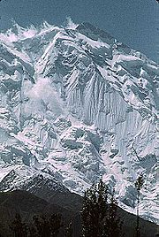 Several high peaks rise above 6000 metres (19,685 ft) in the surroundings of Hunza valley. The valley provides spectacular views of some of the most beautiful and magnificent mountains of the world which include Rakaposhi
7788 metres (25,551.2 ft), Ultar Sar 7388 metres (24,238.8 ft), Bojahagur Duanasir II 7329 metres (24,045.3 ft), Ghenta Sar 7090 metres (23,261.2 ft), Hunza Peak
6270 metres (20,570.9 ft), Darmyani Peak 6090 metres (19,980.3 ft), and Bublimating (Ladyfinger Peak
) 6000 metres (19,685 ft).
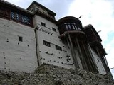
Hunza Valley is also host to the ancient watch towers in Ganish , Baltit Fort
and Altit Fort
. Watch towers are located in heart of Ganish Village
, Baltit Fort
stands on top of Karimabad
whereas Altit Fort
lies at the bottom of the valley.
The valley is popularly believed to be the inspiration for the mythical valley of Shangri-la
in James Hilton
's 1933 novel Lost Horizon
.
One of the main attractions of Duikar is the viewpoint (2900 m) which is a 5 minute climb up behind Eagle’s Nest Hotel. Here you have the best views during sunrise and sunset, if you have the chance come to Eagle’s Nest Hotel at full-moon. Starting from Eagle’s Nest Hotel it is a 1 ½ hours climb up to Hosht (3600 m). From the Hosht viewpoint you have great views of Ultar Mountains and Hopper glacier. The Hunza panorama is wider and dearer here.
 As much as the valley is famous for its beauty, the people of Hunza are noted for their friendliness and hospitality. The local languages spoken are Burushaski
, Wakhi
and Shina
, many people understand Urdu. The literacy rate of the Hunza valley is believed to be more than 90%. Virtually every child of the new generation studies up to at least high school level. Many pursue higher studies from prestigious colleges and Universities of Pakistan
and abroad.
Most of the people of Hunza are Ismaili Shia Muslims, followers of His Highness Prince Karim Aga Khan IV
, while in Ganish Village
more than 90% are Shia Muslims.
The Hunza region is home to people of three ethnicities:
Legislative Council
Assembly (NALA) seat for Hunza.
Pakistan
Pakistan , officially the Islamic Republic of Pakistan is a sovereign state in South Asia. It has a coastline along the Arabian Sea and the Gulf of Oman in the south and is bordered by Afghanistan and Iran in the west, India in the east and China in the far northeast. In the north, Tajikistan...
. The Hunza valley is situated to the north of the Hunza River
Hunza River
Hunza River is the principal river of Hunza, in the Northern Areas of Pakistan. It is formed by the confluence of the Kilik and Khunjerab nalas which are fed by glaciers. It is joined by the Gilgit River and the Naltar River before it flows into the Indus River.The river cuts through the...
, at an elevation of around 2500 metres (8,202.1 ft). The territory of Hunza is about 7900 square kilometres (3,050.2 sq mi). Aliabad
Aliabad
Aliabad is one of the old suburbs in Hyderabad, India. It is part of the old city of Hyderabad. It is very close to the historic Charminar.Aliabad is situated about 2.5 km from Charminar towards Falaknuma palace. Aliabad Darwaza is one of the 8 entrances to the erstwhile Hyderabad...
is the main town with Karimabad as a popular tourist destination because of the spectacular scenery of the surrounding mountains like Ultar Sar, Rakaposhi
Rakaposhi
Rakaposhi , is a mountain in the Karakoram mountain range in Pakistan. It is situated in the Nagar Valley approximately 100 km north of the city of Gilgit in the Gilgit District of the Gilgit-Baltistan province of Pakistan. Rakaposhi means "Snow Covered" in the local language. Rakaposhi is...
, Bojahagur Duanasir II, Ghenta Peak, Hunza Peak
Hunza Peak
Hunza Peak lies in the westernmost subrange of the Karakoram range along with the Ladyfinger Peak . It lies on the southwest ridge of the Ultar Sar massif, the most southeasterly of the major groups of the Batura Muztagh...
, Passu Peak, Diran Peak
Diran
Diran is a mountain in the Karakoram range in Gilgit-Baltistan, Pakistan. This pyramid shaped mountain lies to the east of Rakaposhi ....
and Bublimating (Ladyfinger Peak
Ladyfinger Peak
Bublimotin, Bubli Motin, Bublimating or Ladyfinger Peak, is a distinctive rock spire in the Batura Muztagh, the westernmost subrange of the Karakoram range in Pakistan. It lies on the southwest ridge of the Ultar Sar massif, the most southeasterly of the major groups of the Batura Muztagh. The...
), all 6000 metres (19,685 ft) or higher.
History
Hunza was formerly a princely statePrincely state
A Princely State was a nominally sovereign entitity of British rule in India that was not directly governed by the British, but rather by an Indian ruler under a form of indirect rule such as suzerainty or paramountcy.-British relationship with the Princely States:India under the British Raj ...
, and one of the most loyal vassals to the Maharaja of Jammu and Kashmir
Jammu and Kashmir
Jammu and Kashmir is the northernmost state of India. It is situated mostly in the Himalayan mountains. Jammu and Kashmir shares a border with the states of Himachal Pradesh and Punjab to the south and internationally with the People's Republic of China to the north and east and the...
, bordering China to the north-east and Pamir
Pamir Mountains
The Pamir Mountains are a mountain range in Central Asia formed by the junction or knot of the Himalayas, Tian Shan, Karakoram, Kunlun, and Hindu Kush ranges. They are among the world’s highest mountains and since Victorian times they have been known as the "Roof of the World" a probable...
to its north-west, which continued to survive until 1974, when it was finally dissolved by Zulfikar Ali Bhutto
Zulfikar Ali Bhutto
Zulfikar Ali Bhutto was 9th Prime Minister of Pakistan from 1973 to 1977, and prior to that, 4th President of Pakistan from 1971 to 1973. Bhutto was the founder of the Pakistan Peoples Party — the largest and most influential political party in Pakistan— and served as its chairman until his...
. The state bordered the Gilgit Agency
Gilgit Agency
The Gilgit Agency was a political unit of British India, which administered the northern half of the Princely state of Jammu and Kashmir. The Gilgit Agency was created in 1877 and was overseen by a political agent of the Governor-General of British India. The seat of the agent was Srinagar...
to the south, the former princely state of Nagar to the east. The state capital was the town of Baltit (also known as Karimabad
Karimabad (Hunza)
Karimabad is the capital of Hunza in Gilgit-Baltistan, northern Pakistan. Karimabad is also known as Baltit. It is named after Prince Karim Aga Khan, the spiritual head of Shia Ismaili Nizari community. The Guardian ranked it as the 12th Best Tourist Site in Pakistan.-See also:*Hunza...
) and its old settlement is Ganish Village
Ganish Village
Ganish Village, the oldest and first settlement on the ancient Silk Road in Hunza, is in Pakistan. It is located right in the heart of Hunza Valley, 90 km and 2½ hours traveling time from Gilgit. Ganish means gold in Brushaski...
.Hunza was an independent principality for more than 900 years. The British
British Raj
British Raj was the British rule in the Indian subcontinent between 1858 and 1947; The term can also refer to the period of dominion...
gained control of Hunza and the neighbouring valley of Nagar between 1889 and 1892 followed by a military engagement of severe intensity. The then Thom (Prince) Mir Safdar Ali Khan of Hunza fled to Kashghar in China and sought what can be called political asylum.
First Muslim Thum
Thum
The traditional name for the ruler in Hunza was ThumThum (title)
Thum, sometimes written Tham, was the title of the ruler or Mir of Hunza, a former princely state in the Northern Areas, Pakistan. Thum is also a respectful appellation used by people of both Hunza and Nagar who belong to the Boorish clan. The Shin use the term Yeshkun for the Boorish....
, which is also a respectful appellation used by people of both Hunza and Nager who belong to the clan of Boorish. The Shin use the term Yeshkun for the Boorish.
2010 landslide
In 2010, a landslide blocked the river and creating Attabad LakeAttabad Lake
Attabad Lake, Gojal, also known as Gojal Lake, is a lake in the Hunza Valley of northern Pakistan created in January 2010 by a landslide dam. The lake was formed due to a massive landslide at Attabad village in Gilgit-Baltistan, upstream of Karimabad that occurred on January 4, 2010. The...
, the potential collapse of which threatened the valley below.
Geography
Gandhara
Gandhāra , is the name of an ancient kingdom , located in northern Pakistan and eastern Afghanistan. Gandhara was located mainly in the vale of Peshawar, the Potohar plateau and on the Kabul River...
for a person travelling on foot. The route was impassable to baggage animals; only human porters could get through, and then only with permission from the locals.
Hunza was easily defended as the paths were often less than 0.5 metres (19.7 in) wide. The high mountain paths often crossed bare cliff faces on logs wedged into cracks in the cliff, with stones balanced on top. They were also constantly exposed to regular damage from weather and falling rocks. These were the much feared "hanging passageways" of the early Chinese histories that terrified all, including several famous Chinese Buddhist monks such as Xuanzang
Xuanzang
Xuanzang was a famous Chinese Buddhist monk, scholar, traveler, and translator who described the interaction between China and India in the early Tang period...
.
Climate
Karakoram Highway
The Karakoram Highway is the highest paved international road in the world, but at its peak at the China-Pakistan border it is only paved on the Chinese side. It connects China and Pakistan across the Karakoram mountain range, through the Khunjerab Pass, at an altitude of as confirmed by both...
is often blocked by the snow.
Transport
Today, the famous Karakoram HighwayKarakoram Highway
The Karakoram Highway is the highest paved international road in the world, but at its peak at the China-Pakistan border it is only paved on the Chinese side. It connects China and Pakistan across the Karakoram mountain range, through the Khunjerab Pass, at an altitude of as confirmed by both...
crosses Hunza, connecting Pakistan to China via the Khunjerab Pass
Khunjerab Pass
Khunjerab Pass is a high mountain pass in the Karakoram Mountains in a strategic position on the northern border of Pakistan's Gilgit-Baltistan region within the disputed region of Kashmir and on the southwest border of the Xinjiang region of China...
. Travelling up the valley from the south, Hunza is the land to the left, and the former state of Nagar to the right of the Hunza River
Hunza River
Hunza River is the principal river of Hunza, in the Northern Areas of Pakistan. It is formed by the confluence of the Kilik and Khunjerab nalas which are fed by glaciers. It is joined by the Gilgit River and the Naltar River before it flows into the Indus River.The river cuts through the...
. Regular bus and van services operate between Gilgit
Gilgit
Gilgit is a city in northern PakistanGilgit may refer to other terms related with the area of the city:* Gilgit River* Gilgit Valley* Gilgit District* Gilgit Agency * Gilgit Airport...
and Central Hunza (Ganish Village
Ganish Village
Ganish Village, the oldest and first settlement on the ancient Silk Road in Hunza, is in Pakistan. It is located right in the heart of Hunza Valley, 90 km and 2½ hours traveling time from Gilgit. Ganish means gold in Brushaski...
, Aliabad
Aliabad
Aliabad is one of the old suburbs in Hyderabad, India. It is part of the old city of Hyderabad. It is very close to the historic Charminar.Aliabad is situated about 2.5 km from Charminar towards Falaknuma palace. Aliabad Darwaza is one of the 8 entrances to the erstwhile Hyderabad...
and Karimabad
Karimabad (Hunza)
Karimabad is the capital of Hunza in Gilgit-Baltistan, northern Pakistan. Karimabad is also known as Baltit. It is named after Prince Karim Aga Khan, the spiritual head of Shia Ismaili Nizari community. The Guardian ranked it as the 12th Best Tourist Site in Pakistan.-See also:*Hunza...
) and also between Gilgit and Sost Gojal. PTDC
PTDC
PTDC or Pakistan Tourism Development Corporation is an organization of Government of Pakistan. The PTDC is governed by the Board of Directors headed by the Minister for Tourism...
Office at Gilgit
Gilgit
Gilgit is a city in northern PakistanGilgit may refer to other terms related with the area of the city:* Gilgit River* Gilgit Valley* Gilgit District* Gilgit Agency * Gilgit Airport...
, Sost and Islamabad
Islamabad
Islamabad is the capital of Pakistan and the tenth largest city in the country. Located within the Islamabad Capital Territory , the population of the city has grown from 100,000 in 1951 to 1.7 million in 2011...
arranges tours and transport for visitors.
Spectacular scenery
Rakaposhi
Rakaposhi , is a mountain in the Karakoram mountain range in Pakistan. It is situated in the Nagar Valley approximately 100 km north of the city of Gilgit in the Gilgit District of the Gilgit-Baltistan province of Pakistan. Rakaposhi means "Snow Covered" in the local language. Rakaposhi is...
7788 metres (25,551.2 ft), Ultar Sar 7388 metres (24,238.8 ft), Bojahagur Duanasir II 7329 metres (24,045.3 ft), Ghenta Sar 7090 metres (23,261.2 ft), Hunza Peak
Hunza Peak
Hunza Peak lies in the westernmost subrange of the Karakoram range along with the Ladyfinger Peak . It lies on the southwest ridge of the Ultar Sar massif, the most southeasterly of the major groups of the Batura Muztagh...
6270 metres (20,570.9 ft), Darmyani Peak 6090 metres (19,980.3 ft), and Bublimating (Ladyfinger Peak
Ladyfinger Peak
Bublimotin, Bubli Motin, Bublimating or Ladyfinger Peak, is a distinctive rock spire in the Batura Muztagh, the westernmost subrange of the Karakoram range in Pakistan. It lies on the southwest ridge of the Ultar Sar massif, the most southeasterly of the major groups of the Batura Muztagh. The...
) 6000 metres (19,685 ft).
Hunza Valley is also host to the ancient watch towers in Ganish , Baltit Fort
Baltit Fort
Baltit Fort or Balti Fort is an ancient fort in the Hunza valley in the Northern Areas of Pakistan.In former times survival of the feudal regimes of Hunza was ensured by the impressive Baltit fort, that sit on top of Karimabad. The foundations of the fort are said to date back around 700 years, but...
and Altit Fort
Altit Fort
Altit Fort is an ancient fort above Karimabad in the Hunza valley in the Northern Areas of Pakistan. It was home to the hereditary rulers of the Hunza state who took the title Mir...
. Watch towers are located in heart of Ganish Village
Ganish Village
Ganish Village, the oldest and first settlement on the ancient Silk Road in Hunza, is in Pakistan. It is located right in the heart of Hunza Valley, 90 km and 2½ hours traveling time from Gilgit. Ganish means gold in Brushaski...
, Baltit Fort
Baltit Fort
Baltit Fort or Balti Fort is an ancient fort in the Hunza valley in the Northern Areas of Pakistan.In former times survival of the feudal regimes of Hunza was ensured by the impressive Baltit fort, that sit on top of Karimabad. The foundations of the fort are said to date back around 700 years, but...
stands on top of Karimabad
Karimabad (Hunza)
Karimabad is the capital of Hunza in Gilgit-Baltistan, northern Pakistan. Karimabad is also known as Baltit. It is named after Prince Karim Aga Khan, the spiritual head of Shia Ismaili Nizari community. The Guardian ranked it as the 12th Best Tourist Site in Pakistan.-See also:*Hunza...
whereas Altit Fort
Altit Fort
Altit Fort is an ancient fort above Karimabad in the Hunza valley in the Northern Areas of Pakistan. It was home to the hereditary rulers of the Hunza state who took the title Mir...
lies at the bottom of the valley.
The valley is popularly believed to be the inspiration for the mythical valley of Shangri-la
Shangri-La
Shangri-La is a fictional place described in the 1933 novel Lost Horizon by British author James Hilton. Hilton describes Shangri-La as a mystical, harmonious valley, gently guided from a lamasery, enclosed in the western end of the Kunlun Mountains...
in James Hilton
James Hilton
James Hilton was an English novelist who wrote several best-sellers, including Lost Horizon and Goodbye, Mr. Chips.-Biography:...
's 1933 novel Lost Horizon
Lost Horizon (novel)
Lost Horizon is a 1933 novel by English writer James Hilton. It is best remembered as the origin of Shangri-La, a fictional utopian lamasery high in the mountains of Tibet.-Overview:...
.
Duikar Valley Hunza
Duikar is a charming hamlet above the village of Altit which is situated next to Baltit, Karimabad. Karimabad is the capital of the former state of Hunza. The state of Hunza was ruled by the same family for over 960 years, with their seat being the Baltit Fort. Both Baltit Fort and the even older Altit Fort are worth a visitor before you come up to Duikar or on your way down.One of the main attractions of Duikar is the viewpoint (2900 m) which is a 5 minute climb up behind Eagle’s Nest Hotel. Here you have the best views during sunrise and sunset, if you have the chance come to Eagle’s Nest Hotel at full-moon. Starting from Eagle’s Nest Hotel it is a 1 ½ hours climb up to Hosht (3600 m). From the Hosht viewpoint you have great views of Ultar Mountains and Hopper glacier. The Hunza panorama is wider and dearer here.
People of Hunza
Burushaski language
The Burushaski or Burushko language , is a language isolate . It is spoken by some 87,000 Burusho people in the Hunza, Nagar, Yasin, and Ishkoman valleys, and some parts of the Gilgit valley, in Gilgit–Baltistan in Pakistan and by about 300 Burusho people in Srinagar in Jammu and Kashmir, India...
, Wakhi
Wakhi language
Wakhi is an Indo-European language in the branch of Eastern Iranian language family and is intimately related to other Southeastern Iranian languages in the Pamir languages group.-Classification and Distribution:...
and Shina
Shina language
Shina is a Dardic language spoken by a plurality of people in Gilgit-Baltistan of Pakistan and Dras in Ladakh of Indian-Administered Kashmir. The valleys in which it is spoken include Astore, Chilas, Dareil, Tangeer, Gilgit, Ghizer, and a few parts of Baltistan and Kohistan. It is also spoken in...
, many people understand Urdu. The literacy rate of the Hunza valley is believed to be more than 90%. Virtually every child of the new generation studies up to at least high school level. Many pursue higher studies from prestigious colleges and Universities of Pakistan
Pakistan
Pakistan , officially the Islamic Republic of Pakistan is a sovereign state in South Asia. It has a coastline along the Arabian Sea and the Gulf of Oman in the south and is bordered by Afghanistan and Iran in the west, India in the east and China in the far northeast. In the north, Tajikistan...
and abroad.
Most of the people of Hunza are Ismaili Shia Muslims, followers of His Highness Prince Karim Aga Khan IV
Aga Khan IV
Prince Karim, Aga Khan IV, NPk, NI, KBE, CC, GCC, GCIH, GCM is the 49th and current Imam of the Shia Imami Nizari Ismaili Muslims. He has held this position under the title of Aga Khan since July 11, 1957, when, at the age of 20, he succeeded his grandfather, Sultan Mahomed Shah Aga Khan...
, while in Ganish Village
Ganish Village
Ganish Village, the oldest and first settlement on the ancient Silk Road in Hunza, is in Pakistan. It is located right in the heart of Hunza Valley, 90 km and 2½ hours traveling time from Gilgit. Ganish means gold in Brushaski...
more than 90% are Shia Muslims.
The Hunza region is home to people of three ethnicities:
- The Lower Hunza area - (from KhizerabadKhizerabad-See also:* Former State of Hunza* Baltit Fort* Altit Fort* Northern Areas* Karakoram Highway* Karakoram Mountains* Nagar Valley* Burusho* Ganish Village* Hunza Valley* Karimabad* Aliabad* Nasirabad* Ahmedabad* Hussainabad* Murtazaabad* Sikandarabad...
to NasirabadNasirabad (Hunza)Nasirabad is a town located in Hunza-Nagar District of Northern Areas in Pakistan....
is mainly inhabited by the ShinakiShinakiShinaki is the name given to the people living in the Lower Hunza, Pakistan.Hunza Valley has generally three parts, namely "Lower Hunza", "Centre Hunza" and "Upper Hunza". The lower part includes mainly four villages namely Hussainabad, Mayon, Khanabad and Nasirabad .Historically Shinakis are...
people who are ShinaShina languageShina is a Dardic language spoken by a plurality of people in Gilgit-Baltistan of Pakistan and Dras in Ladakh of Indian-Administered Kashmir. The valleys in which it is spoken include Astore, Chilas, Dareil, Tangeer, Gilgit, Ghizer, and a few parts of Baltistan and Kohistan. It is also spoken in...
speakers; - The Central Hunza area - (from MurtazaabadMurtazaabadMurtazaabad is the first village of central Hunza in the Northern Areas of Pakistan. It is situated along the Hunza River.-Geographic location:...
to Atta abad) is mainly inhabited by BurushaskiBurushaski languageThe Burushaski or Burushko language , is a language isolate . It is spoken by some 87,000 Burusho people in the Hunza, Nagar, Yasin, and Ishkoman valleys, and some parts of the Gilgit valley, in Gilgit–Baltistan in Pakistan and by about 300 Burusho people in Srinagar in Jammu and Kashmir, India...
speakers. - The Upper Hunza area, known as GojalGojalGojal, also known as Upper Hunza, is an area north of Gilgit in the far north of Pakistan near the Chinese and Afghan borders. It is the largest tehsil of the Gilgit-Baltistan autonomous area of northern Pakistan....
- (from Shiskat to KhunjerabKhunjerabKhunjerab may refer to:*Khunjerab Pass, the highest paved road crossing of an international border in the world, between China and Pakistan* Khunjerab Valley* Khunjerab River*Khunjerab National Park, a National Park in Pakistan...
is mainly populated by WakhiWakhi languageWakhi is an Indo-European language in the branch of Eastern Iranian language family and is intimately related to other Southeastern Iranian languages in the Pamir languages group.-Classification and Distribution:...
speakers;
New District
Hunza-Nagar became a new district in Gilgit-Baltistan starting in July, 2009. There is planned to be a Northern AreasNorthern Areas
Gilgit-Baltistan , is the northernmost political entity within Pakistan. It borders Pakistan's Khyber Pukhtunkhwa province to the west, Afghanistan's Wakhan Corridor to the north, China to the east and northeast, Azad Kashmir to the southwest, and Indian-administered Jammu and Kashmir to the...
Legislative Council
Legislative Council
A Legislative Council is the name given to the legislatures, or one of the chambers of the legislature of many nations and colonies.A Member of the Legislative Council is commonly referred to as an MLC.- Unicameral legislatures :...
Assembly (NALA) seat for Hunza.
See also
- State of Hunza (former)
- Hunza-Nagar DistrictHunza-Nagar DistrictThe Hunza-Nagar District is the seventh district of Gilgit-Baltistan of Pakistan. The district comprises Hunza and Nagar. Aliabad is the administrative center of this district...
- Northern Areas (former)Northern AreasGilgit-Baltistan , is the northernmost political entity within Pakistan. It borders Pakistan's Khyber Pukhtunkhwa province to the west, Afghanistan's Wakhan Corridor to the north, China to the east and northeast, Azad Kashmir to the southwest, and Indian-administered Jammu and Kashmir to the...
- Silk Road transmission of BuddhismSilk Road transmission of BuddhismThe Silk Road transmission of Buddhism to China is most commonly thought to have started in the late 2nd or the 1st century CE.The first documented translation efforts by Buddhist monks in China were in the 2nd century CE, possibly as a consequence of the expansion of the Kushan Empire into the...
- Karakoram HighwayKarakoram HighwayThe Karakoram Highway is the highest paved international road in the world, but at its peak at the China-Pakistan border it is only paved on the Chinese side. It connects China and Pakistan across the Karakoram mountain range, through the Khunjerab Pass, at an altitude of as confirmed by both...
- Karakoram Mountains
- Nagar ValleyNagar ValleyThe Nagar Valley is a valley near Gilgit Valley in the Gilgit Baltistan of Pakistan. The valley is part of Hunza Nagar District and is administratively subdivided into two tehsils namely Nagar-1 and Nagar-2. The valley is situated at an elevation of 2,438m . Nagar Khas is the main town and the...
- AhmedabadAhmedabad (Hunza)Ahmedabad is located in the Hunza-Nagar District of Gilgit-Baltistan, Pakistan.-See also:* Former State of Hunza* Baltit Fort* Altit Fort* Northern Areas* Karakoram Highway* Karakoram Mountains* Nagar Valley* Burusho* Ganish Village* Hunza Valley...
- Altit FortAltit FortAltit Fort is an ancient fort above Karimabad in the Hunza valley in the Northern Areas of Pakistan. It was home to the hereditary rulers of the Hunza state who took the title Mir...
- Baltit FortBaltit FortBaltit Fort or Balti Fort is an ancient fort in the Hunza valley in the Northern Areas of Pakistan.In former times survival of the feudal regimes of Hunza was ensured by the impressive Baltit fort, that sit on top of Karimabad. The foundations of the fort are said to date back around 700 years, but...
- Burusho
- Ganish VillageGanish VillageGanish Village, the oldest and first settlement on the ancient Silk Road in Hunza, is in Pakistan. It is located right in the heart of Hunza Valley, 90 km and 2½ hours traveling time from Gilgit. Ganish means gold in Brushaski...
- HussainabadHussainabad (Hunza)Hussainabad is a small village situated at the left bank of Hunza River. There are around 200 homes which population is approximately 1,500 people. The literacy rate of Hussainabad is 100%. In Hussain Abad, Khizerabad, Qadeem Abad, Centre, Shabaran & Dolmani....
- Jafarabad
- KarimabadKarimabad (Hunza)Karimabad is the capital of Hunza in Gilgit-Baltistan, northern Pakistan. Karimabad is also known as Baltit. It is named after Prince Karim Aga Khan, the spiritual head of Shia Ismaili Nizari community. The Guardian ranked it as the 12th Best Tourist Site in Pakistan.-See also:*Hunza...
- KhizerabadKhizerabad-See also:* Former State of Hunza* Baltit Fort* Altit Fort* Northern Areas* Karakoram Highway* Karakoram Mountains* Nagar Valley* Burusho* Ganish Village* Hunza Valley* Karimabad* Aliabad* Nasirabad* Ahmedabad* Hussainabad* Murtazaabad* Sikandarabad...
- MurtazaabadMurtazaabadMurtazaabad is the first village of central Hunza in the Northern Areas of Pakistan. It is situated along the Hunza River.-Geographic location:...
- NasirabadNasirabad (Hunza)Nasirabad is a town located in Hunza-Nagar District of Northern Areas in Pakistan....
- PassuPassuPassu is a small village on the Karakoram Highway, beside the Hunza River, some 15 kilometers from Gulmit, the Tehsil Headquarter of Gojal in the Gilgit-Baltistan region of Pakistan, and about 150 km upriver from Gilgit. It lies very near the tongue of the Pasu Glacier, and just south of the...
- SikandarabadSikandarabadSikandarabad is the located in Hunza-Nagar District of Gilgit-Baltistan in Pakistan.-See also:* Former State of Hunza* Baltit Fort* Altit Fort* Northern Areas* Karakoram Highway* Karakoram Mountains* Nagar Valley* Burusho* Ganish Village...
- WakhiWakhiWakhi may be:* The Wakhi language, the language of the majority of the people of Wakhan* Wakhi, an ethnic group in Wakhan, Afghanistan* An adjective; of or relating to Wakhan, the extreme northeastern region of Afghanistan that borders China, Tajikistan, and Pakistan...