

Chilas
Encyclopedia
Pakistan
Pakistan , officially the Islamic Republic of Pakistan is a sovereign state in South Asia. It has a coastline along the Arabian Sea and the Gulf of Oman in the south and is bordered by Afghanistan and Iran in the west, India in the east and China in the far northeast. In the north, Tajikistan...
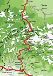
on the left side of river Indus. It is part of the Silk Road
Silk Road
The Silk Road or Silk Route refers to a historical network of interlinking trade routes across the Afro-Eurasian landmass that connected East, South, and Western Asia with the Mediterranean and European world, as well as parts of North and East Africa...
connected by the Karakoram Highway
Karakoram Highway
The Karakoram Highway is the highest paved international road in the world, but at its peak at the China-Pakistan border it is only paved on the Chinese side. It connects China and Pakistan across the Karakoram mountain range, through the Khunjerab Pass, at an altitude of as confirmed by both...
which links it to Islamabad
Islamabad
Islamabad is the capital of Pakistan and the tenth largest city in the country. Located within the Islamabad Capital Territory , the population of the city has grown from 100,000 in 1951 to 1.7 million in 2011...
in the south via Dassu
Dassu
Dassu, also spelt Dusso, is a town in the Gilgit-Baltistan of Pakistan. It is located at 35°43'0N 75°31'0E' and has an altitude of 2440 metres ....
, Besham
Besham
Besham is the largest town and commercial centre of the Shangla District in Khyber-Pakhtunkhwa province of Pakistan. Most of the population is pashto speaking pashtun....
, Mansehra
Mansehra
Mansehra city is located at in Mansehra District, Khyber-Pakhtunkhwa province of Pakistan. It is very near to Abbottabad city. It is a major stop for tourists on the Karakoram Highway which leads to China...
, Abbottabad
Abbottabad
Abbottabad is a city located in the Hazara region of the Khyber Pakhtunkhwa province, in Pakistan. The city is situated in the Orash Valley, northeast of the capital Islamabad and east of Peshawar at an altitude of and is the capital of the Abbottabad District...
and Haripur. In the north, Chilas is connected to the Chinese
China
Chinese civilization may refer to:* China for more general discussion of the country.* Chinese culture* Greater China, the transnational community of ethnic Chinese.* History of China* Sinosphere, the area historically affected by Chinese culture...
cities of Kashgar
Kashgar
Kashgar or Kashi is an oasis city with approximately 350,000 residents in the western part of the Xinjiang Uyghur Autonomous Region of the People's Republic of China. Kashgar is the administrative centre of Kashgar Prefecture which has an area of 162,000 km² and a population of approximately...
and Tashkurgan via Gilgit
Gilgit
Gilgit is a city in northern PakistanGilgit may refer to other terms related with the area of the city:* Gilgit River* Gilgit Valley* Gilgit District* Gilgit Agency * Gilgit Airport...
, Sust
Sust
Sust or Sost is a dry port in Gojal region of the Northern Areas of Pakistan. It is the last town inside Pakistan on the Karakoram Highway before the Chinese border...
and the Khunjerab pass.
Ancient petroglyphs
There are more than 50,000 pieces of rock art (petroglyphPetroglyph
Petroglyphs are pictogram and logogram images created by removing part of a rock surface by incising, picking, carving, and abrading. Outside North America, scholars often use terms such as "carving", "engraving", or other descriptions of the technique to refer to such images...
s) and inscriptions all along the Karakoram Highway
Karakoram Highway
The Karakoram Highway is the highest paved international road in the world, but at its peak at the China-Pakistan border it is only paved on the Chinese side. It connects China and Pakistan across the Karakoram mountain range, through the Khunjerab Pass, at an altitude of as confirmed by both...
in Northern Areas
Northern Areas
Gilgit-Baltistan , is the northernmost political entity within Pakistan. It borders Pakistan's Khyber Pukhtunkhwa province to the west, Afghanistan's Wakhan Corridor to the north, China to the east and northeast, Azad Kashmir to the southwest, and Indian-administered Jammu and Kashmir to the...
of Pakistan
Pakistan
Pakistan , officially the Islamic Republic of Pakistan is a sovereign state in South Asia. It has a coastline along the Arabian Sea and the Gulf of Oman in the south and is bordered by Afghanistan and Iran in the west, India in the east and China in the far northeast. In the north, Tajikistan...
that are concentrated at ten major sites between Hunza
Hunza Valley
The Hunza Valley is a mountainous valley in the Gilgit-Baltistan region of Pakistan. The Hunza valley is situated to the north of the Hunza River, at an elevation of around . The territory of Hunza is about...
and Shatial, more have been found in the area of Skardu and Shigar (in Shigar even the remains of a Buddhist monastery were found in 1984 by Jettmar and Thewalt). The carvings were left by various invaders, traders and pilgrim
Pilgrim
A pilgrim is a traveler who is on a journey to a holy place. Typically, this is a physical journeying to some place of special significance to the adherent of a particular religious belief system...
s who passed along the trade route, as well as by locals. The earliest date back to between 5000 and 1000 BC
Anno Domini
and Before Christ are designations used to label or number years used with the Julian and Gregorian calendars....
, showing single animals, triangular men and hunting scenes in which the animals sometimes are larger than the hunters. These carvings
Stone carving
Stone carving is an ancient activity where pieces of rough natural stone are shaped by the controlled removal of stone. Owing to the permanence of the material, evidence can be found that even the earliest societies indulged in some form of stone work....
were pecked into the rocks with stone tools and are covered with a thick patina
Patina
Patina is a tarnish that forms on the surface of bronze and similar metals ; a sheen on wooden furniture produced by age, wear, and polishing; or any such acquired change of a surface through age and exposure...
that proves their age. Later - mostly Buddhist - carvings were sometimes executed with a sharp chisel.
The ethnologist Karl Jettmar has tried to piece together the history of the area from various inscriptions and recorded his findings in "Rockcarvings and Inscriptions in the Northern Areas of Pakistan" and the later released "Between Gandhara and the Silk Roads -- Rock carvings along the Karakoram Highway".
It is interesting to note that the Kharoshthi term "Kaboa" ( or Kamboa) appears in a short commemorative Kharosthi inscription found from Chilas as reported by the Archaeological Department of Pakistan
Pakistan
Pakistan , officially the Islamic Republic of Pakistan is a sovereign state in South Asia. It has a coastline along the Arabian Sea and the Gulf of Oman in the south and is bordered by Afghanistan and Iran in the west, India in the east and China in the far northeast. In the north, Tajikistan...
. The inscription has been transcribed, translated and interpreted by Ahmad Hasan Dani
Ahmad Hasan Dani
Professor Ahmad Hasan Dani FRAS, SI, HI , was a Pakistani intellectual, archaeologist, historian, and linguist. He was among the foremost authorities on Central Asian and South Asian archaeology and history. He introduced archaeology as a discipline in higher education in Pakistan and Bangladesh...
, a Pakistani archaeologist, historian, and linguist, who was among the foremost authorities on South Asian archaeology
Archaeology
Archaeology, or archeology , is the study of human society, primarily through the recovery and analysis of the material culture and environmental data that they have left behind, which includes artifacts, architecture, biofacts and cultural landscapes...
and history. According to Dani, Kaboa or Kamboa of the inscription is a Kharoshthised form of Sanskrit
Sanskrit
Sanskrit , is a historical Indo-Aryan language and the primary liturgical language of Hinduism, Jainism and Buddhism.Buddhism: besides Pali, see Buddhist Hybrid Sanskrit Today, it is listed as one of the 22 scheduled languages of India and is an official language of the state of Uttarakhand...
Kamboja . Thus, it seems likely that Chilas also formed part of ancient Kamboja kingdom.
Chilas comes under Gilgit-Baltistan. The weather is hot and dry in the summer and dry and cold in the winter. It can be reached through Karakoram highway and also from the Kaghan valley passing over the Babusar Pass. Chilas is situated on the left bank of the mighty river Indus. Foreigners may need permission to travel in Chilas.
See also
- Karakoram HighwayKarakoram HighwayThe Karakoram Highway is the highest paved international road in the world, but at its peak at the China-Pakistan border it is only paved on the Chinese side. It connects China and Pakistan across the Karakoram mountain range, through the Khunjerab Pass, at an altitude of as confirmed by both...
- Parri BanglaParri BanglaParri Bangla is a village 20 km from Gilgit city, Gilgit-Baltistan. Its ancient name was Pari which come to be known as Parri. The Karakoram Highway crosses Parri Bangla and also connects it to Juglot, Chilas, Mansehra, Abbottabad and Islamabad to the south. In the North it is connected to...
- Northern AreasNorthern AreasGilgit-Baltistan , is the northernmost political entity within Pakistan. It borders Pakistan's Khyber Pukhtunkhwa province to the west, Afghanistan's Wakhan Corridor to the north, China to the east and northeast, Azad Kashmir to the southwest, and Indian-administered Jammu and Kashmir to the...
- Chilas AirportChilas AirportChilas Airport is located at Chilas, a town in the Northern Areas of Pakistan. Currently it is not being used by any passenger airline. The two major airports in Northern Areas are Gilgit Airport and Skardu Airport.-See also:* List of airports in Pakistan...
- Mountains on Webshots.com