
Geography of Lebanon
Encyclopedia
Lebanon
Lebanon , officially the Republic of LebanonRepublic of Lebanon is the most common term used by Lebanese government agencies. The term Lebanese Republic, a literal translation of the official Arabic and French names that is not used in today's world. Arabic is the most common language spoken among...
stretches along the east side of the Mediterranean Sea
Mediterranean Sea
The Mediterranean Sea is a sea connected to the Atlantic Ocean surrounded by the Mediterranean region and almost completely enclosed by land: on the north by Anatolia and Europe, on the south by North Africa, and on the east by the Levant...
, its length almost three times its width. As it stretches from North to South, the width of its terrain becomes narrower. Lebanon's mountainous terrain, proximity to the sea, and strategic location at a crossroads of the world were decisive factors in shaping its history. The political, economic, and religious movements that either originated in the region or crossed through to leave an imprint upon Lebanese society give form to that history.
The country's role in the region, as indeed in the world at large, was shaped by trade. The area, formerly part of the region known as Greater Syria, served as a link between the Mediterranean world and India
India
India , officially the Republic of India , is a country in South Asia. It is the seventh-largest country by geographical area, the second-most populous country with over 1.2 billion people, and the most populous democracy in the world...
and East Asia
East Asia
East Asia or Eastern Asia is a subregion of Asia that can be defined in either geographical or cultural terms...
. The merchant
Merchant
A merchant is a businessperson who trades in commodities that were produced by others, in order to earn a profit.Merchants can be one of two types:# A wholesale merchant operates in the chain between producer and retail merchant...
s of the region exported oil
Petroleum
Petroleum or crude oil is a naturally occurring, flammable liquid consisting of a complex mixture of hydrocarbons of various molecular weights and other liquid organic compounds, that are found in geologic formations beneath the Earth's surface. Petroleum is recovered mostly through oil drilling...
, grain
GRAIN
GRAIN is a small international non-profit organisation that works to support small farmers and social movements in their struggles for community-controlled and biodiversity-based food systems. Our support takes the form of independent research and analysis, networking at local, regional and...
, textile
Textile
A textile or cloth is a flexible woven material consisting of a network of natural or artificial fibres often referred to as thread or yarn. Yarn is produced by spinning raw fibres of wool, flax, cotton, or other material to produce long strands...
s, metal work
Metalworking
Metalworking is the process of working with metals to create individual parts, assemblies, or large scale structures. The term covers a wide range of work from large ships and bridges to precise engine parts and delicate jewelry. It therefore includes a correspondingly wide range of skills,...
, and pottery
Pottery
Pottery is the material from which the potteryware is made, of which major types include earthenware, stoneware and porcelain. The place where such wares are made is also called a pottery . Pottery also refers to the art or craft of the potter or the manufacture of pottery...
through the port
Port
A port is a location on a coast or shore containing one or more harbors where ships can dock and transfer people or cargo to or from land....
cities to Western
Western world
The Western world, also known as the West and the Occident , is a term referring to the countries of Western Europe , the countries of the Americas, as well all countries of Northern and Central Europe, Australia and New Zealand...
markets. The linkage role of Lebanon was further enhanced by the nomads of the Syrian
Syrian Desert
The Syrian Desert , also known as the Syro-Arabian desert is a combination of steppe and true desert that is located in the northern Arabian Peninsula covering 200,000 square miles . also the desert is very rocky and flat...
and Arabian
Arabian Desert
The Arabian Desert is a vast desert wilderness stretching from Yemen to the Persian Gulf and Oman to Jordan and Iraq. It occupies most of the Arabian Peninsula, with an area of...
deserts who visited the cities of Syria to trade. The caravans developed limited routes that often led to the coastal cities of Tripoli
Tripoli, Lebanon
Tripoli is the largest city in northern Lebanon and the second-largest city in Lebanon. Situated 85 km north of the capital Beirut, Tripoli is the capital of the North Governorate and the Tripoli District. Geographically located on the east of the Mediterranean, the city's history dates back...
, Beirut
Beirut
Beirut is the capital and largest city of Lebanon, with a population ranging from 1 million to more than 2 million . Located on a peninsula at the midpoint of Lebanon's Mediterranean coastline, it serves as the country's largest and main seaport, and also forms the Beirut Metropolitan...
, Sidon
Sidon
Sidon or Saïda is the third-largest city in Lebanon. It is located in the South Governorate of Lebanon, on the Mediterranean coast, about 40 km north of Tyre and 40 km south of the capital Beirut. In Genesis, Sidon is the son of Canaan the grandson of Noah...
, or Tyre. This created a merchant class and brought wealth to the inhabitants of the region. The trade between East and West led to the development of a cosmopolitan
Multiculturalism
Multiculturalism is the appreciation, acceptance or promotion of multiple cultures, applied to the demographic make-up of a specific place, usually at the organizational level, e.g...
culture in Lebanon's port cities, whose inhabitants became known for their multilingualism, flexibility, moderation, and commercial acumen.
Lebanon was also affected by regional political conflicts and social movements. The wealth of the region attracted powerful rulers who coveted its resources. The strategic location was also attractive; it was used either as a defensive position against enemies approaching the Arab hinterland
Hinterland
The hinterland is the land or district behind a coast or the shoreline of a river. Specifically, by the doctrine of the hinterland, the word is applied to the inland region lying behind a port, claimed by the state that owns the coast. The area from which products are delivered to a port for...
or as a stepping-stone toward Lebanon's neighbors. Over the centuries, members of the nomadic tribes of the Arabian Peninsula
Arabian Peninsula
The Arabian Peninsula is a land mass situated north-east of Africa. Also known as Arabia or the Arabian subcontinent, it is the world's largest peninsula and covers 3,237,500 km2...
sought a more prosperous life in Lebanon. To this day, many Lebanese families take pride in tracing their descent to ancient tribes of Arabia. Moreover, refugees belonging to minority sects have settled in its virtually inaccessible mountain valleys. Hence, the region became a melting pot of cultural and/or social interaction among diverse groups. In a social culture where blood lineage assumed primacy as a source of identification and affiliation, the contrast between the new Arab immigrant tribes and the settled inhabitants of the land frequently produced conflicts. Also, Lebanon is part of Southwestern Asia, and it is located at about approximately 35˚N, 35˚W.
Land
The physical geography of Lebanon is influenced by natural systems that extend outside the country. Thus, the Beqaa Valley
Beqaa Valley
The Beqaa Valley is a fertile valley in east Lebanon. For the Romans, the Beqaa Valley was a major agricultural source, and today it remains Lebanon’s most important farming region...
is part of the Great Rift system, which stretches from southern Turkey
Turkey
Turkey , known officially as the Republic of Turkey , is a Eurasian country located in Western Asia and in East Thrace in Southeastern Europe...
to Mozambique
Mozambique
Mozambique, officially the Republic of Mozambique , is a country in southeastern Africa bordered by the Indian Ocean to the east, Tanzania to the north, Malawi and Zambia to the northwest, Zimbabwe to the west and Swaziland and South Africa to the southwest...
in Africa. Like any mountainous country, Lebanon's physical geography is complex. Land forms, climate, soils, and vegetation differ markedly within short distances. There are also sharp changes in other elements of the environment, from good to poor soils, as one moves through the Lebanese mountains.
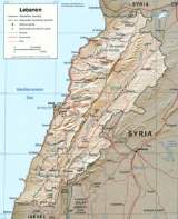
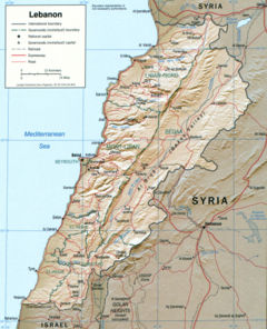
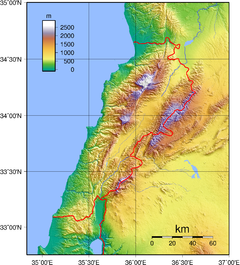
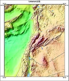
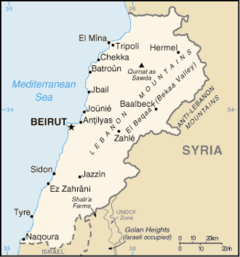
A major feature of Lebanese topography is the alternation of lowland and highland that runs generally parallel with a north-to-south orientation. There are four such longitudinal strips between the Mediterranean Sea and Syria: the coastal strip (or the maritime plain), western Lebanon, the central plateau, and eastern Lebanon (see fig. 3, Physical Features).
The extremely narrow coastal strip stretches along the shore of the eastern Mediterranean. Hemmed in between sea and mountain, the sahil, as it is called in Lebanon, is widest in the north near Tripoli, where it is only 6.5 kilometers wide. A few kilometers south at Juniyah the approximately 1.5-kilometer-wide plain is succeeded by foothills that rise steeply to 750 meters within 6.5 kilometers from the sea. For the most part, the coast is abrupt and rocky. The shoreline is regular with no deep estuary
Estuary
An estuary is a partly enclosed coastal body of water with one or more rivers or streams flowing into it, and with a free connection to the open sea....
, gulf
Headlands and bays
Headlands and bays are two related features of the coastal environment.- Geology and geography :Headlands and bays are often found on the same coastline. A bay is surrounded by land on three sides, whereas a headland is surrounded by water on three sides. Headlands are characterized by high,...
, or natural harbor. The maritime plain is especially productive of fruits and vegetables.
The western range, the second major region, is the Lebanon Mountains, sometimes called Mount Lebanon, or Lebanon proper before 1920. Since Roman
Ancient Rome
Ancient Rome was a thriving civilization that grew on the Italian Peninsula as early as the 8th century BC. Located along the Mediterranean Sea and centered on the city of Rome, it expanded to one of the largest empires in the ancient world....
days the term Mount Lebanon
Mount Lebanon
Mount Lebanon , as a geographic designation, is a Lebanese mountain range, averaging above 2,200 meters in height and receiving a substantial amount of precipitation, including snow, which averages around four meters deep. It extends across the whole country along about , parallel to the...
has encompassed this area. Antilibanos (Anti-Lebanon) was used to designate the eastern range. Geologists believe that the twin mountains once formed one range. The Lebanon Mountains are the highest, most rugged, and most imposing of the whole maritime range of mountains and plateaus that start with the Amanus or Nur Mountains
Nur Mountains
The Nur Mountains , also known as Gâvur Mountains , the ancient Amanus , is a mountain range in the Hatay Province of south-central Turkey, which runs roughly parallel to the Gulf of İskenderun....
in northern Syria and end with the towering massif of Sinai
Sinai Peninsula
The Sinai Peninsula or Sinai is a triangular peninsula in Egypt about in area. It is situated between the Mediterranean Sea to the north, and the Red Sea to the south, and is the only part of Egyptian territory located in Asia as opposed to Africa, effectively serving as a land bridge between two...
. The mountain structure forms the first barrier to communication between the Mediterranean and Lebanon's eastern hinterland. The mountain range is a clearly defined unit having natural boundaries on all four sides. On the north it is separated from the Nusayriyah Mountains
Al-Ansariyah mountains
An-Nusayriyah Mountains also known as al-Alawiyeen Mountains , both names refer to the Alawi sect which has traditionally lived there, and the Syrian official name, Coastal Mountain Range ; are a mountain range in northwestern Syria running north-south, parallel to the coastal plain...
of Syria by An Nahr al Kabir
Nahr al-Kabir
Nahr al-Kabir al-Janoubi is a river in the Middle East flowing into the Mediterranean Sea. The river flows through the Homs Gap....
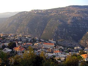
("the great river"); on the south it is bounded by Al Qasimiyah River, giving it a length of 169 kilometers. Its width varies from about 56.5 kilometers near Tripoli to 9.5 kilometers on the southern end. It rises to alpine heights southeast of Tripoli, where Al Qurnat as Sawda ("the black nook") reaches 3,088 meters. Of the other peaks that rise east of Beirut, Jabal Sannin (2,695 meters) is the highest. Ahl al Jabal ("people of the mountain"), or simply jabaliyyun, has referred traditionally to the inhabitants of western Lebanon. Near its southern end, the Lebanon Mountains branch off to the west to form the Shuf Mountains.
The third geographical region is the Biqa Valley. This central highland between the Lebanon Mountains and the Anti-Lebanon Mountains is about 177 kilometers in length and 9.6 to 16 kilometers wide and has an average elevation of 762 meters. Its middle section spreads out more than its two extremities. Geologically, the Biqa is the medial part of a depression that extends north to the western bend of the Orontes River
Orontes River
The Orontes or ‘Āṣī is a river of Lebanon, Syria and Turkey.It was anciently the chief river of the Levant, also called Draco, Typhon and Axius...
in Syria and south to Jordan
Jordan
Jordan , officially the Hashemite Kingdom of Jordan , Al-Mamlaka al-Urduniyya al-Hashemiyya) is a kingdom on the East Bank of the River Jordan. The country borders Saudi Arabia to the east and south-east, Iraq to the north-east, Syria to the north and the West Bank and Israel to the west, sharing...
through Al Arabah
Arabah
The Arabah , also known as Aravah, is a section of the Great Rift Valley running in a north-south orientation between the southern end of the Sea of Galilee down to the Dead Sea and continuing further south where it ends at the Gulf of Aqaba. It includes most of the border between Israel to the...
to Al Aqabah
Aqaba
Aqaba is a coastal city in the far south of Jordan, the capital of Aqaba Governorate at the head of the Gulf of Aqaba. Aqaba is strategically important to Jordan as it is the country's only seaport. Aqaba is best known today as a diving and beach resort, but industrial activity remains important...
, the eastern arm of the Red Sea
Red Sea
The Red Sea is a seawater inlet of the Indian Ocean, lying between Africa and Asia. The connection to the ocean is in the south through the Bab el Mandeb strait and the Gulf of Aden. In the north, there is the Sinai Peninsula, the Gulf of Aqaba, and the Gulf of Suez...
. The Biqa is the country's chief agricultural area and served as a granary of Roman Syria. Biqa is the Arabic plural of buqaah, meaning a place with stagnant water.
Emerging from a base south of Homs
Homs
Homs , previously known as Emesa , is a city in western Syria and the capital of the Homs Governorate. It is above sea level and is located north of Damascus...
in Syria, the eastern mountain range, or Anti-Lebanon (Lubnan ash Sharqi), is almost equal in length and height to the Lebanon Mountains. This fourth geographical region falls swiftly from Mount Hermon
Mount Hermon
Mount Hermon is a mountain cluster in the Anti-Lebanon mountain range. Its summit straddles the border between Syria and Lebanon and, at 2,814 m above sea level, is the highest point in Syria. On the top there is “Hermon Hotel”, in the buffer zone between Syria and Israeli-occupied...
to the Hawran Plateau, whence it continues through Jordan south to the Dead Sea
Dead Sea
The Dead Sea , also called the Salt Sea, is a salt lake bordering Jordan to the east and Israel and the West Bank to the west. Its surface and shores are below sea level, the lowest elevation on the Earth's surface. The Dead Sea is deep, the deepest hypersaline lake in the world...
. The Barada Gorge divides Anti-Lebanon. In the northern section, few villages are on the western slopes, but in the southern section, featuring Mount Hermon (2860 meters), the western slopes have many villages. Anti-Lebanon is more arid, especially in its northern parts, than Mount Lebanon and is consequently less productive and more thinly populated? hi
Terrain
- The Shoreline. At 210 km (130.49 mi) long, it is mostly consisted of rocksRock (geology)In geology, rock or stone is a naturally occurring solid aggregate of minerals and/or mineraloids.The Earth's outer solid layer, the lithosphere, is made of rock. In general rocks are of three types, namely, igneous, sedimentary, and metamorphic...
towards north, and sandSandSand is a naturally occurring granular material composed of finely divided rock and mineral particles.The composition of sand is highly variable, depending on the local rock sources and conditions, but the most common constituent of sand in inland continental settings and non-tropical coastal...
south, adding some headlands, baysHeadlands and baysHeadlands and bays are two related features of the coastal environment.- Geology and geography :Headlands and bays are often found on the same coastline. A bay is surrounded by land on three sides, whereas a headland is surrounded by water on three sides. Headlands are characterized by high,...
, and offshore islandIslandAn island or isle is any piece of sub-continental land that is surrounded by water. Very small islands such as emergent land features on atolls can be called islets, cays or keys. An island in a river or lake may be called an eyot , or holm...
s - The Coastal plain. Surrounded by sea and mountains, it is rather narrow at 2 or 3 km (1.86 mi) wide
- Mount LebanonMount LebanonMount Lebanon , as a geographic designation, is a Lebanese mountain range, averaging above 2,200 meters in height and receiving a substantial amount of precipitation, including snow, which averages around four meters deep. It extends across the whole country along about , parallel to the...
(the West Mountains). - Beqaa valleyBeqaa ValleyThe Beqaa Valley is a fertile valley in east Lebanon. For the Romans, the Beqaa Valley was a major agricultural source, and today it remains Lebanon’s most important farming region...
. - Anti-LebanonAnti-LebanonThe Anti-Lebanon mountains is the Western name for the Eastern Lebanon Mountain Range , which are a southwest-northeast-trending mountain range between Syria and Lebanon. Its Western name comes from the Greek word for ‘opposite’. The majority of the mountain range lies in Syria. The border between...
(the East Mountains).
Climate

Mediterranean climate
A Mediterranean climate is the climate typical of most of the lands in the Mediterranean Basin, and is a particular variety of subtropical climate...
characterized by a long, hot, and dry summer, and cool, rainy winter. Fall is a transitional season with a gradual lowering of temperature and little rain; spring occurs when the winter rains cause the vegetation to revive. Topographical variation creates local modifications of the basic climatic pattern. Along the coast, summers are hot and humid, with little or no rain. Heavy dews form, which are beneficial to agriculture. The daily range of temperature is not wide. A west wind provides relief during the afternoon and evening; at night the wind direction is reversed, blowing from the land out to sea.
Winter is the rainy season, with major precipitation falling after December. Rainfall is generous but is concentrated during only a few days of the rainy season, falling in heavy cloudbursts. The amount of rainfall varies greatly from one year to another. Occasionally, there are frosts during the winter, and about once every fifteen years a light powdering of snow falls as far south as Beirut. A hot wind blowing from the Egyptian desert called the khamsin
Khamsin
Khamsin, khamseen, chamsin or hamsin , also known as khamaseen refers to a dry, hot and dusty local wind blowing in North Africa and the Arabian Peninsula. Similar winds in the area are sirocco and simoom...
(Arabic for "fifty"), may provide a warming trend during the fall, but more often occurs during the spring. Bitterly cold winds may have come from Europe. Along the coast the proximity to the sea provides a moderating influence on the climate, making the range of temperatures narrower than it is inland, but the temperatures are cooler in the northern parts of the coast where there is also more rain.
In the Lebanon Mountains the gradual increase in altitude produces colder winters with more precipitation and snow. The summers have a wider daily range of temperatures and less humidity. In the winter, frosts are frequent and snows heavy; in fact, snow covers the highest peaks for much of the year. In the summer, temperatures may rise as high during the daytime as they do along the coast, but they fall far lower at night. Inhabitants of the coastal cities, as well as visitors, seek refuge from the oppressive humidity of the coast by spending much of the summer in the mountains, where numerous summer resorts are located. Both the khamsin and the north winter wind are felt in the Lebanon Mountains. The influence of the Mediterranean Sea is abated by the altitude and, although the precipitation is even higher than it is along the coast, the range of temperatures is wider and the winters are more severe.
The Biqa Valley and the Anti-Lebanon Mountains are shielded from the influence of the sea by the Lebanon Mountains. The result is considerably less precipitation and humidity and a wider variation in daily and yearly temperatures. The khamsin does not occur in the Biqa Valley, but the north winter wind is so severe that the inhabitants say it can "break nails." Despite the relatively low altitude of the Biqa Valley (the highest point of which, near Baalbek
Baalbek
Baalbek is a town in the Beqaa Valley of Lebanon, altitude , situated east of the Litani River. It is famous for its exquisitely detailed yet monumentally scaled temple ruins of the Roman period, when Baalbek, then known as Heliopolis, was one of the largest sanctuaries in the Empire...
, is only 1100 metres (3,609 ft)) more snow falls there than at comparable altitudes west of the Lebanon Mountains.
Because of their altitudes, the Anti-Lebanon Mountains receive more precipitation than the Biqa Valley, despite their remoteness from maritime influences. Much of this precipitation appears as snow, and the peaks of the Anti-Lebanon, like those of the Lebanon Mountains, are snow-covered for much of the year. Temperatures are cooler than in the Biqa Valley.
The Biqa Valley is watered by two rivers that rise in the watershed near Baalbek: the Orontes flowing north (in Arabic it is called Nahr al Asi, "the Rebel River", because this direction is unusual), and the Litani flowing south into the hill region of the southern Biqa Valley, where it makes an abrupt turn to the west in southern Lebanon
Southern Lebanon
Southern Lebanon is the geographical area of Lebanon comprising the South Governorate and the Nabatiye Governorate. These two entities were divided from the same province in the early 1990s...
and is thereafter called the Al Qasmiyah River. The Orontes continues to flow north into Syria and eventually reaches the Mediterranean in Turkey. Its waters, for much of its course, flow through a channel considerably lower than the surface of the ground. The Nahr Barada, which waters Damascus
Damascus
Damascus , commonly known in Syria as Al Sham , and as the City of Jasmine , is the capital and the second largest city of Syria after Aleppo, both are part of the country's 14 governorates. In addition to being one of the oldest continuously inhabited cities in the world, Damascus is a major...
, has as its source a spring in the Anti-Lebanon Mountains.
Smaller springs and streams serve as tributaries to the principal rivers. Because the rivers and streams have such steep gradients and are so fast moving, they are erosive instead of depository in nature. This process is aided by the soft character of the limestone that composes much of the mountains, the steep slopes of the mountains, and the heavy rainstorms. The only permanent lake is Buhayrat al Qirawn, about ten kilometers east of Jezzine
Jezzine
Jezzine is a town in Lebanon, located from Sidon and south of Beirut. Surrounded by mountain peaks, pine forests, and at an average altitude of 950 m , it is the main summer resort and tourist destination of South Lebanon...
. There is one seasonal lake, fed by springs, on the eastern slopes of the Lebanon Mountains near Yammunah, about 40 kilometres (25 mi) southeast of Tripoli.
Area and boundaries
land: 10280 square kilometre
water: 170 square kilometre
Land boundaries:
total: 454 km (282 mi)
border countries: Israel 79 km (49.1 mi), Syria 375 km (233 mi)
Coastline: 210 km (130 mi)
Maritime claims:
territorial sea: 12 nmi (22.2 km; 13.8 mi)
Elevation extremes:
lowest point: Mediterranean Sea
Mediterranean Sea
The Mediterranean Sea is a sea connected to the Atlantic Ocean surrounded by the Mediterranean region and almost completely enclosed by land: on the north by Anatolia and Europe, on the south by North Africa, and on the east by the Levant...
0 m (0 ft) (sea level
Sea level
Mean sea level is a measure of the average height of the ocean's surface ; used as a standard in reckoning land elevation...
)
highest point: Qurnat as Sawda'
Qurnat as Sawda'
Qurnat as Sawdā’ is the highest point in Lebanon, at 3,088 meters above sea level.Lebanon Peaks Mount Lebanon peaks above 1800m are covered with snow almost 4 months a year, and the peaks above 2500m are covered around 6 months a year....
3088 m (10,131 ft)
Resources and land use
LimestoneLimestone
Limestone is a sedimentary rock composed largely of the minerals calcite and aragonite, which are different crystal forms of calcium carbonate . Many limestones are composed from skeletal fragments of marine organisms such as coral or foraminifera....
, iron ore, salt
Salt
In chemistry, salts are ionic compounds that result from the neutralization reaction of an acid and a base. They are composed of cations and anions so that the product is electrically neutral...
, water
Water
Water is a chemical substance with the chemical formula H2O. A water molecule contains one oxygen and two hydrogen atoms connected by covalent bonds. Water is a liquid at ambient conditions, but it often co-exists on Earth with its solid state, ice, and gaseous state . Water also exists in a...
-surplus state in a water-deficit region, arable land
arable land: 21%
permanent crops: 9%
permanent pastures: 1%
forests and woodland: 8%
other: 61% (1993 est.)
Irrigated land: 860 km² (332.05 sq mi) (1993 est.)
Environmental concerns
Natural hazardNatural hazard
A natural hazard is a threat of a naturally occurring event that will have a negative effect on people or the environment. Many natural hazards are interrelated, e.g. earthquakes can cause tsunamis and drought can lead directly to famine. It is possible that some natural hazards are...
s include dust storm
Dust storm
A dust / sand storm is a meteorological phenomenon common in arid and semi-arid regions. Dust storms arise when a gust front or other strong wind blows loose sand and dirt from a dry surface. Particles are transported by saltation and suspension, causing soil to move from one place and deposition...
s.
Current environmental degradation
Environmental degradation
Environmental degradation is the deterioration of the environment through depletion of resources such as air, water and soil; the destruction of ecosystems and the extinction of wildlife...
concerns include deforestation
Deforestation
Deforestation is the removal of a forest or stand of trees where the land is thereafter converted to a nonforest use. Examples of deforestation include conversion of forestland to farms, ranches, or urban use....
, soil erosion
Erosion
Erosion is when materials are removed from the surface and changed into something else. It only works by hydraulic actions and transport of solids in the natural environment, and leads to the deposition of these materials elsewhere...
, desertification
Desertification
Desertification is the degradation of land in drylands. Caused by a variety of factors, such as climate change and human activities, desertification is one of the most significant global environmental problems.-Definitions:...
, air pollution
Air pollution
Air pollution is the introduction of chemicals, particulate matter, or biological materials that cause harm or discomfort to humans or other living organisms, or cause damage to the natural environment or built environment, into the atmosphere....
in Beirut from vehicular traffic and the burning of industrial waste
Industrial waste
Industrial waste is a type of waste produced by industrial activity, such as that of factories, mills and mines. It has existed since the outset of the industrial revolution....
s, and pollution of coastal watboundary. Lebanon's rugged terrain historically helped isolate, protect, and develop numerous factional groups based on religion, clan, and ethnicity.