
Southern Lebanon
Encyclopedia
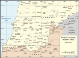
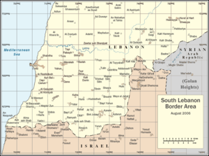
Southern Lebanon is the geographical area of Lebanon
comprising the South Governorate
and the Nabatiye Governorate
. These two entities were divided from the same province in the early 1990s. The Rashaya
and Western Beqaa
Districts, the southernmost districts of the Beqaa Governorate
, in Southern Lebanon are sometimes included in this description.
The main cities of the region are Sidon
, Tyre, Jezzine and Nabatiyeh. The cazas of Bint Jbeil
, Tyre, and Nabatieh in Southern Lebanon are known for their large Shi'a Muslim
population with a minority of Christians. Sidon
is predominately Sunni, with the rest of the caza of Sidon having a Shi'a Muslim majority, with a considerable Christian
minority, mainly Greek Catholics. The cazas of Jezzine
and Marjeyoun have a Christian majority and also Shia Muslims. The villages of Ain Ebel
, Debel
, Qaouzah
, and Rmaich
are entirely Christian Maronite. The caza of Hasbaya
has a Druze
majority.
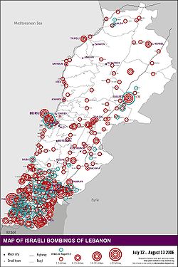
Southern Lebanon has featured prominently in the Israel-Lebanon conflict
.
five years ago. Both Israel
and the United States
condemned the trip as being "provocative."
Ahmadinejad was welcomed by tens of thousands of supporters of Hezbollah, Iran's Shiite Muslim ally in Lebanon which the United States and Israel have branded a terrorist organization, despite its participation in Lebanon's fragile government.
Lebanon
Lebanon , officially the Republic of LebanonRepublic of Lebanon is the most common term used by Lebanese government agencies. The term Lebanese Republic, a literal translation of the official Arabic and French names that is not used in today's world. Arabic is the most common language spoken among...
comprising the South Governorate
South Governorate
South Governorate is one of the governorates of Lebanon. South Lebanon has a population of 500,000 inhabitants and an area of 2,000 km². The capital is Sidon. The lowest elevation is sea-level; the highest is 1,000 meters. The inhabitants are a mixture of Shiites, Sunnis, Orthodox,...
and the Nabatiye Governorate
Nabatiye Governorate
Nabatieh Governorate is one of the six governorates of Lebanon. The area of this governorate is 1,058 km². The capital is Nabatieh.-Districts:The governorate is divided into four districts containing 115 municipalities...
. These two entities were divided from the same province in the early 1990s. The Rashaya
Rashaya District
Rashaya District is an administrative district in the Beqaa Governorate of the Republic of Lebanon.Most of Rachaya's population are Christians with a large Druze minority. Many people of Rachaya have left for larger cities in Lebanon such as Beirut...
and Western Beqaa
Western Beqaa District
Western Beqaa District is an administrative district in the Beqaa Governorate of the Republic of Lebanon. The capital is Joub Jannine....
Districts, the southernmost districts of the Beqaa Governorate
Beqaa Governorate
Beqaa is a governorate in Lebanon with a population of 750,000 inhabitants.-Geography:The Beqaa governorate covers an area of 4,429 km². Béqaa is the primary center of Lebanon's agriculture. The Beqaa governorate forms the main geographical extension of Lebanon and it lies between the Western...
, in Southern Lebanon are sometimes included in this description.
The main cities of the region are Sidon
Sidon
Sidon or Saïda is the third-largest city in Lebanon. It is located in the South Governorate of Lebanon, on the Mediterranean coast, about 40 km north of Tyre and 40 km south of the capital Beirut. In Genesis, Sidon is the son of Canaan the grandson of Noah...
, Tyre, Jezzine and Nabatiyeh. The cazas of Bint Jbeil
Bint Jbeil
Bint Jbeil is the second largest town in the Nabatiye Governorate in Southern Lebanon.The town has an estimated population of 30,000. Its exact population is unknown, because Lebanon has not conducted a population census since 1932.-History:...
, Tyre, and Nabatieh in Southern Lebanon are known for their large Shi'a Muslim
Muslim
A Muslim, also spelled Moslem, is an adherent of Islam, a monotheistic, Abrahamic religion based on the Quran, which Muslims consider the verbatim word of God as revealed to prophet Muhammad. "Muslim" is the Arabic term for "submitter" .Muslims believe that God is one and incomparable...
population with a minority of Christians. Sidon
Sidon
Sidon or Saïda is the third-largest city in Lebanon. It is located in the South Governorate of Lebanon, on the Mediterranean coast, about 40 km north of Tyre and 40 km south of the capital Beirut. In Genesis, Sidon is the son of Canaan the grandson of Noah...
is predominately Sunni, with the rest of the caza of Sidon having a Shi'a Muslim majority, with a considerable Christian
Christian
A Christian is a person who adheres to Christianity, an Abrahamic, monotheistic religion based on the life and teachings of Jesus of Nazareth as recorded in the Canonical gospels and the letters of the New Testament...
minority, mainly Greek Catholics. The cazas of Jezzine
Jezzine
Jezzine is a town in Lebanon, located from Sidon and south of Beirut. Surrounded by mountain peaks, pine forests, and at an average altitude of 950 m , it is the main summer resort and tourist destination of South Lebanon...
and Marjeyoun have a Christian majority and also Shia Muslims. The villages of Ain Ebel
Ain Ebel
Ain Ebel is a village located in the Caza of Bint Jbeil in the Nabatiye Governorate in Lebanon.-Etymology:Historians as Anis Freiha and Fr Youakim Moubarak believe that the name of Ain-Ebel derives from two words,"Ain" and "Ibl".The first means spring as many places in Lebanon are named,and the...
, Debel
Debel
Debel may refer to:* Debel, Lebanon* Debel, Oromo Name, Oromo, Ethiopia, African name for a boy meaning 'in addition to, gift of '* Debel, Ethiopia, a town in the Afar Region...
, Qaouzah
Qaouzah
Qaouzah is a Lebanese village located in the Caza of Bint Jbeil in the Nabatiye Governorate in Lebanon.-Geography:Qaouzah occupies a hill with elevation ranging from 700 to 800 meters above sea level...
, and Rmaich
Rmaich
Rmeish is located in south Lebanon, Caza Beint Jbeil near the Lebanese-Israeli border occupying an area of 20 km2. The ruins found in the village indicate that the area was occupied by the Romans and the Crusaders at some stage in history...
are entirely Christian Maronite. The caza of Hasbaya
Hasbaya
Hasbeya or Hasbeiya is a town in Lebanon, situated about 36 miles to the west of Damascus, at the foot of Mount Hermon, overlooking a deep amphitheatre from which a brook flows to the Hasbani. In 1911, the population was about 5000....
has a Druze
Druze
The Druze are an esoteric, monotheistic religious community, found primarily in Syria, Lebanon, Israel, and Jordan, which emerged during the 11th century from Ismailism. The Druze have an eclectic set of beliefs that incorporate several elements from Abrahamic religions, Gnosticism, Neoplatonism...
majority.
Southern Lebanon has featured prominently in the Israel-Lebanon conflict
Israel-Lebanon conflict
The Israeli–Lebanese conflict describes a series of related military clashes involving Israel, Lebanon, and Syria, as well as various non-state militias acting from within Lebanon....
.
Ahmadinejad's state visit
In October 2010 Iranian President Mahmoud Ahmadinejad visited South Lebanon. This was his first visit to Lebanon since he first assumed office in TehranTehran
Tehran , sometimes spelled Teheran, is the capital of Iran and Tehran Province. With an estimated population of 8,429,807; it is also Iran's largest urban area and city, one of the largest cities in Western Asia, and is the world's 19th largest city.In the 20th century, Tehran was subject to...
five years ago. Both Israel
Israel
The State of Israel is a parliamentary republic located in the Middle East, along the eastern shore of the Mediterranean Sea...
and the United States
United States
The United States of America is a federal constitutional republic comprising fifty states and a federal district...
condemned the trip as being "provocative."
Ahmadinejad was welcomed by tens of thousands of supporters of Hezbollah, Iran's Shiite Muslim ally in Lebanon which the United States and Israel have branded a terrorist organization, despite its participation in Lebanon's fragile government.
Cities and districts
- Al Rihan
- Aalma ach Chaab (Alma ash Shab)
- Abbasieh
- Adasse or AdaissehAdaissehAdaisseh is a village in South Lebanon. It is located close to the Blue Line border with Israel, near the Israeli kibbutz Misgav Am.-History:...
or Addaisseh - Adlun
- Al Mansuri
- Ain EbelAin EbelAin Ebel is a village located in the Caza of Bint Jbeil in the Nabatiye Governorate in Lebanon.-Etymology:Historians as Anis Freiha and Fr Youakim Moubarak believe that the name of Ain-Ebel derives from two words,"Ain" and "Ibl".The first means spring as many places in Lebanon are named,and the...
- Ain BaalAin BaalAin Baal is a Lebanese village located in the Caza of Tyre in the Southern Governorate of Lebanon.-Origin of name:According to the Lebanese dialect, the name of the village means "the water well of Baal".-About Ain Baal:...
or Ayn Bal - AitarounAitarounAitaroun is a Lebanese village located in the caza of Bint-Jbeil at 33.1156° North, 35.4722° East. It is approximately 15 km north of the Israeli border and 125 km from Beirut.- Population :...
or Aytarun - Ansariyeh or Insariye
- AnsarAnsar, LebanonAnsar or Insar is a village in the Nabatieh Governorate region of southern Lebanon between Nabatieh and Tyr. During the Lebanese civil war in the 1980s it was the location of a detention camp for suspected Palestinian terrorists and allied Muslim militiamen captured by the Israeli military in...
- Ash Shawmara
- At Tayyabah
- At Tiri
- Aitit
- AynataAynataAynata is a village in Lebanon. It is located in the southern portion of the country . A stronghold for Hezbollah, during the war with Israel in 2006, about 60% of the homes in the town were destroyed....
- Ayta al-Sha`b (Ayta)
- Baraachit
- Barish
- Bayt Lif
- baytulay
- Bazouryeh
- Beit Yahoun
- Bint JbeilBint JbeilBint Jbeil is the second largest town in the Nabatiye Governorate in Southern Lebanon.The town has an estimated population of 30,000. Its exact population is unknown, because Lebanon has not conducted a population census since 1932.-History:...
- Blida, Lebanon
- Borj el Shamali or Borj Chemali
- Borj Qalaouiyeh
- Borj Rahal
- Boustane
- Brashit
- Braikeh
- Chaqra
- Chtoura
- Deir Kifa
- DeyrintarDeyrintarDeyrintar is a small village in Southern Lebanon. It is about south of Beirut and east of Tyre, in the heart of what is known as "Jabal Amel".Its main features include a cave, a main square, and 3 mosques....
- Dayr Qanun
- Derdghaya
- Dibil or DebelDebelDebel may refer to:* Debel, Lebanon* Debel, Oromo Name, Oromo, Ethiopia, African name for a boy meaning 'in addition to, gift of '* Debel, Ethiopia, a town in the Afar Region...
- DoueirDoueirDoueir , or Dweir, is a village of 7,500 inhabitants in Southern Lebanon near Nabatiyeh and north of the Litani River...
- Ebel el Saki
- El Biyyadah or Al Bayyadah
- El Hennyeh or Al Hinniyah
- El Mansoun or Al Mansuri
- El Qlaile or Al Qulaylah
- El Soultaniyeh
- Frun
- Ghandouriyeh
- Jabal AmelJabal AmelJabal Amel or Amil is a mountainous region of Southern Lebanon.The region is named after the Banu 'Amilah, a Yemenite tribe who, along with the kindred tribes of Hamadan, Lakhm, and Judham, settled in Syria, Palestine, parts of Jordan, and Lebanon. The area was known in ancient times as Jabal...
- jebchet
- Jmaijmah
- Joiya or Jouaya or Jwayya
- Ghaziyeh
- Ghassaniyeh
- Hadata or Haddathah
- Hanaway
- HarrisHarris (disambiguation)-Places:In Canada:* Harris, Ontario* Harris, Saskatchewan* Harris No. 316, SaskatchewanIn Scotland:* Harris, Outer Hebrides - In the United States:*Harris, California*Harris, Indiana*Harris, Iowa...
or Harres - Houla or HulaHulaHula is a dance form accompanied by chant or song . It was developed in the Hawaiian Islands by the Polynesians who originally settled there. The hula dramatizes or portrays the words of the oli or mele in a visual dance form....
- Kabrikha or Qabrikha
- kaakaeit al jesser
- Kafr DuninKafr DuninKfar Dunin is a village in Lebanon, 102 km from the capital Beirut and 580 m from sea coast remote. Adjacent villages: Deir Kifa, Alkaline, Khirbat Silm, Der Ntar. It is considered first of villages in Bent Jbeil district of Nabatieh Governorate. Its population is 6000 people....
- Kafr Kila
- KfarmelkiKfarmelkiKfarmelki , is a town in the Sidon District or Saïda, Kfarmelki (also known as Kafr melki, Kfarmilki), is a town in the Sidon District or Saïda, Kfarmelki (also known as Kafr melki, Kfarmilki), is a town in the Sidon District or Saïda, (Arabic ' ; South Governorate, Lebanon...
or Kfar Melky - Kafarrouman
- Khirbet SelmKhirbet SelmKhirbet Selm is a village in southern Lebanon....
- KfarchoubaKfarchoubaKfarchouba Is a Lebanese village , in the Nabatieh Governorate in Southern Lebanon. Situated in the region of Arkoub 1256 m above sea level and is 130 km from Beirut...
- KfarfilaKfarfilaKfarfila , is a town in the Nabatieh Governorate, al-Nabatiya, or Nabatiye southern Lebanon.It is one of the 243 towns of Nabatieh Governorate, situated at the northern region of this district, at the other side of Al-Kateh; a shallow but wide valley, separating a group of 32 towns from the Sidon...
- KfarhamamKfarhamamKfarhamam is a small village located in the Arqoob region in the Hasbaya District in Southern Lebanon, which lies on the eastern side of the Nabatieh Governorate...
- Kfar Tebnit
- Kounin
- Maachouq
- MahrounaMahrounaMahrouna is a small agribusiness town located in the south of Lebanon.It is situated at a distance of 100 kilometres from Beirut the country's capital, and 18 kilometres to the southeast of the city of Tyre. Mahrouna stands at a height of 400 meter above sea level. The population is approximately...
- MarkabaMarkabaMarkaba is a village located at Marjayoun municipality at Nabatieh Governorate, Lebanon. It is geographically located south of Raabatt Tallame, East of Banni Hayyan and North east of Tallussah and 850 M larges.- Climate:...
- Marakeh
- Majdel BalhisMajdel BalhisMajdel Balhis is a village and municipality located in the Rashaya District and south of the Beqaa Governorate.of the Republic of Lebanon. Majdel Balhis is 95 km away from Beirut. Its altitude is 1100 meters above sea level. The area of Majdel Balhis covers 2004 hectares....
- Majdel Selm or Majdal Zun
- Marqaba or MarkabaMarkabaMarkaba is a village located at Marjayoun municipality at Nabatieh Governorate, Lebanon. It is geographically located south of Raabatt Tallame, East of Banni Hayyan and North east of Tallussah and 850 M larges.- Climate:...
- Maroun al-RasMaroun al-RasMaroun al-Ras is a Lebanese village nestled in Jabal Amel in the district of Bint Jbeil in the Nabatiye Governorate in southern Lebanon...
- MarwahinMarwahinMarwahin is a town in Lebanon, on its border with Israel.During the 2006 Lebanon War, Marwahin was the site of ground exchanges between Israel and Hezbollah. UNIFIL forces reported seeing Hezbollah fire rockets from the vicinity of the village and during operations in Marwahin, and Israel Defense...
- Ma3rub
- Meidoun
- Meiss el Jabal or Mays al Jabal
- Mlikh
- NabatiyeNabatiyeNabatieh , or Nabatiye, is the principal town of the Nabatieh Governorate, in southern Lebanon. Nabatieh has approximately 120,000 inhabitants, is the capital of the Jabal Amel area and the chief center for both the mohafazat, or governorate, and the caza, or canton...
or Nabatiyeh - NaqouraNaqouraNaqoura is a small city in southern Lebanon. Since March 23, 1978 until present, the United Nations Interim Force in Lebanon has been headquartered in Naqoura....
or Nakoura or An Naqurah - NihaNihaNiha is a city in the Chouf which belongs to Mount Lebanon of Lebanon.The city is 24 miles from Beirut and it has about 2,750 hectares; there are 3,500 inhabitants approximately. However, there are only two public schools in the city. It is famous because of its olive groves and its grapes,...
- Majdal Zun
- MarjayounMarjayounMarjayoun is a Lebanese town and administrative district, Marjeyoun District, in the Nabatieh Governorate in Southern Lebanon...
-- a Lebanese Christian village http://www.guardian.co.uk/israel/Story/0,,1841637,00.html - Oum el Ahmad
- Qlayaa
- QanaQanaQana also spelled Cana is a village in southern Lebanon located southeast of the city of Tyre and north of the border with Israel. The 10,000 residents of Qana are primarily Shiite Muslim although there is also a Christian community in the village....
- Qantara
- KhiamKhiam'Khiam' is a town located in South Lebanon Governorate, near the city of Nabatieh. It is located in Southern Lebanon, 750 meters above sea level, 120 km away from Beirut and roughly four kilometers from the Israeli border.The town was the scene of a major confrontation between the Israeli...
- Wadi at Taim
- RachafRachafRachaf or Rshaf is a village in the Bint Jbeil District of the Nabatieh Governorate of Southern Lebanon, 16 kilometres from the Israel-Lebanon border.- Etymology :...
-- a small town - Ramyah
- Ras Al-Biyada
- RmaichRmaichRmeish is located in south Lebanon, Caza Beint Jbeil near the Lebanese-Israeli border occupying an area of 20 km2. The ruins found in the village indicate that the area was occupied by the Romans and the Crusaders at some stage in history...
- Rmadyeh
- Selaa
- Shabriha
- ShebaaShebaaShebaa may refer to:* Shebaa, Lebanon, a village* Shebaa Farms, an area disputed by Israel, Syria and LebanonSee also*Shaba...
and/or Shebaa FarmsShebaa farmsThe Shebaa Farms are a small uninhabited territory claimed by Lebanon, but occupied by Israel which claims they are in Syria's Golan Heights. Syrian policy is to vaguely accept the Lebanese claim, while refusing any binding demarcation until Israeli forces withdraw from the area.The United Nations...
(ownership disputed, occupied by Israel since 1967) - Shihin
- Shhur
- Siddiqine
- ZibqinZibqinZibqin is a town in South Lebanon, from the capital, Beirut, 4 km from the border with Israel. It is above sea level. The town contains old Roman and Greek ruins....
- SidonSidonSidon or Saïda is the third-largest city in Lebanon. It is located in the South Governorate of Lebanon, on the Mediterranean coast, about 40 km north of Tyre and 40 km south of the capital Beirut. In Genesis, Sidon is the son of Canaan the grandson of Noah...
or Saida - SrifaSrifaSrifa is a town in Southern Lebanon, located in Tyros District, Governorate of South Lebanon. It is located 22 kilomteres east of the city Tyros and 90 kilometers south of the capital Beirut. It is the birthplace of Rima Fakih, Miss USA 2010....
- SujodSujod-Sources:*...
- Tallousa
- Tair Debbe
- Tayr Harfa or Tair Harfa
- Tayr Falsayh
- TaibehTaibehTaibeh is the name of several Middle Eastern places.* Tayibe, a city in central Israel* Tayibe, Galilee, a village in northern Israel* Taibeh, Lebanon, a city in southern Lebanon* Taybeh, a city near Ramallah in the central West Bank...
- TebnineTebnineTebnine is a Mediterranean village spread across several hills located about east of Tyre , in the heart of what is known as "Jabal Amel" or the mountain of "Amel". "Jabal Amel" designates the plateau situated between the western mountain range of Lebanon and the Galilee...
or TibninTebnineTebnine is a Mediterranean village spread across several hills located about east of Tyre , in the heart of what is known as "Jabal Amel" or the mountain of "Amel". "Jabal Amel" designates the plateau situated between the western mountain range of Lebanon and the Galilee...
or TibneenTebnineTebnine is a Mediterranean village spread across several hills located about east of Tyre , in the heart of what is known as "Jabal Amel" or the mountain of "Amel". "Jabal Amel" designates the plateau situated between the western mountain range of Lebanon and the Galilee...
http://www.tebnine.org Site of the former castleCastleA castle is a type of fortified structure built in Europe and the Middle East during the Middle Ages by European nobility. Scholars debate the scope of the word castle, but usually consider it to be the private fortified residence of a lord or noble...
town ToronToronToron, now Tibnin or Tebnine in southern Lebanon, was a major Crusader castle, built in the Lebanon mountains on the road from Tyre to Damascus.... - Toulin or TulinTülinTülin is a common feminine Turkish given name. In Turkish, "Tülin" means "Halo around the moon". "Tülin", "Aylin", and "Ayla" are synonymous given names.-People:* Tülin Altıntaş , a Turkish volleyball player....
- TuraTura-People:*Cosimo Tura , Italian painter*Will Tura , Belgian singer*Tura language-Places:*Tura Beach, New South Wales, a community in Australia*Tura, Egypt, a town in Cairo Governorate*Tura, Hungary, a city in Pest County...
- Tyre or Sur
- SaidaSidonSidon or Saïda is the third-largest city in Lebanon. It is located in the South Governorate of Lebanon, on the Mediterranean coast, about 40 km north of Tyre and 40 km south of the capital Beirut. In Genesis, Sidon is the son of Canaan the grandson of Noah...
district - JezzineJezzineJezzine is a town in Lebanon, located from Sidon and south of Beirut. Surrounded by mountain peaks, pine forests, and at an average altitude of 950 m , it is the main summer resort and tourist destination of South Lebanon...
district - Tyre district
- Yarin
- YarounYarounYaroun is a Lebanese village located in the Caza of Bint Jbeil in the Nabatiye Governorate in Lebanon.-Geography:...
or Yarun - Yahun
- Yatar or YaterYaterYater is a Lebanese municipality located in Bint Jbeil District. It is 112 kilometers away from Beirut....
- Zibdine
- Zibqeen
Other notable geographic sites
- Abou Assouad River
- Awali River
- El Zahrani River
- Litani RiverLitani RiverThe Litani River is an important water resource in southern Lebanon. The river rises in the fertile Beqaa Valley valley, west of Baalbek, and empties into the Mediterranean Sea north of Tyre. Exceeding 140 km in length, the Litani River is the longest river in Lebanon and provides an average...
- Saitaniq River
- Kasmieh River
- Blue Line (Lebanon)Blue Line (Lebanon)The Blue Line is a border demarcation between Lebanon and Israel published by the United Nations on 7 June 2000 for the purposes of determining whether Israel had fully withdrawn from Lebanon...
- Beaufort CastleBeaufort Castle, LebanonBeaufort or Belfort The castle was named "bel fort" or "beau fort" by the Crusaders who occupied the castle in the twelfth century. Its Arabic name Qala'at ash-Shqif means Castle of the High Rock...
- Several Palestinian refugee camps in Lebanon including Ain al-HilwehAin al-HilwehAin al-Hilweh is the largest Palestinian refugee camp in Lebanon with over 70,000 refugees, located on the outskirts of the port of Sidon. Because Lebanese Armed Forces are not allowed to enter the camp Ain al-Hilweh has been called a "zone of unlaw" by the Lebanese media...
, Nabatieh campNabatieh campNabatieh was a Palestinian refugee camp in southern Lebanon that was destroyed between the years 1982-1991. Most of the population was moved to Ein el-Helweh....
and WavelWavelWavel is a Palestinian refugee camp near the city of Baalbeck in Lebanon. It was originally French army barracks, but in 1948 refugees from the Palestine war found shelter there. In 1952, UNRWA took over responsibility for providing services in the camp....
.
See also
- South Lebanon ArmySouth Lebanon ArmyThe South Lebanon Army , also "South Lebanese Army," was a Lebanese militia during the Lebanese Civil War. After 1979, the militia operated in southern Lebanon under the authority of Saad Haddad's Government of Free Lebanon...
- South Lebanon conflict (1982–2000)
- North District (Israel)North District (Israel)The Northern District is one of Israel's six administrative districts. The Northern District has a land area of 4,478 km², which increases to 4,638 km² when both land and water are included...
- Operation LitaniOperation LitaniThe 1978 South Lebanon conflict was an invasion in Lebanon up to the Litani River carried out by the Israel Defense Forces in 1978. It was a military success for the Israeli Defense Forces, as PLO forces were pushed north of the river...
against the Lebanese National MovementLebanese National MovementThe Lebanese National Movement or Mouvement National Libanais in French, was a front of parties and organizations active during the early years of the Lebanese Civil War... - United Nations Interim Force in LebanonUnited Nations Interim Force in LebanonThe United Nations Interim Force in Lebanon, or UNIFIL, was created by the United Nations, with the adoption of Security Council Resolution 425 and 426 on 19 March 1978, to confirm Israeli withdrawal from Lebanon which Israel had invaded five days prior, restore international peace and security,...
(instituted by United Nations Security Council Resolution 425United Nations Security Council Resolution 425United Nations Security Council Resolution 425, adopted on March 19, 1978, five days after the Israeli invasion of Lebanon, called on Israel to withdraw immediately its forces from Lebanon and established the United Nations Interim Force In Lebanon...
) - Israeli Security ZoneIsraeli Security ZoneThe Israeli Security Zone in southern Lebanon was a strip of territory of varying width, , from the Israeli border and the Golan Heights, occupied by Israeli forces from 1985 to 2000. Additional regions controlled by the South Lebanon Army are sometimes included under the term...