
Doab
Encyclopedia
A Doab is a term used in India
and Pakistan
for a "tongue" or tract of land lying between two confluent rivers. - see Ap (water)
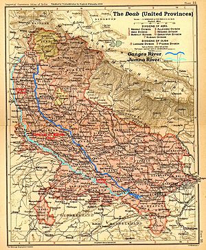
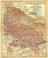
 The Doab, unqualified by the names of any rivers, designates the flat alluvial tract between the Ganges and Yamuna
rivers in western and southwestern Uttar Pradesh
and Uttarakhand
state in India
, extending from the Shiwalik range to the two rivers' confluence at Allahabad
. The region has an area of about 23,360 square miles (60,500 square km); it is approximately 500 miles (805 km) in length and 60 miles (97 km) in width.
Doab figures prominently in history and myths of Vedic period
; the epic Mahabharata
, for example, is set in the Doab, around the city of Hastinapur.
The following districts/states form part of the Doab:
Upper Doab:
Dehradun
, Rishikesh, Muzaffarnagar
, Saharanpur
, Meerut, Ghaziabad, Gautam Buddha Nagar, Baghpat and Bulandshahar
Central or Middle Doab:
Etah
, Aligarh, Agra
, Hathras
, Firozabad
, Mathura and Agra
(Mathura are in trans-Yamuna region of Braj
).
Lower Doab:
Farrukhabad
, Mainpuri
, Etawah
, Kannauj
, Auraiya
, Kanpur Urban, Kanpur Rural, Fatehpur, Kaushambi and Allahabad
.
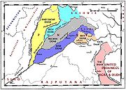 Each of the tracts of land lying between the confluent rivers of the Punjab region
of Pakistan and India (the Indus basin) has a distinct name, said to have been coined by Raja Todar Mal
, a minister of the Mughal
emperor Akbar. The names (except for 'Sindh Sagar') are a combination of the first letters, in the Persian alphabet, of the names of the rivers that bound the Doab. For example, Jech = 'Je'(Jhelum) + 'Ch'(Chenab). The names are (from west to east):
In addition, the tract of land lying between the Sutlej and the Yamuna river is sometimes called the Delhi doab, although, strictly speaking, it is not a doab, since its two bounding rivers, the Yamuna and Sutlej, are not confluent. Recently it is the proposed name of the former Eastern Punjab for Land of two Rivers not five, because they are now situated in Pakistan.
is the triangular region of Andhra Pradesh
and Karnataka
states which lies between the Krishna River
and its tributary the Tungabhadra River
, named for the town of Raichur
.
India
India , officially the Republic of India , is a country in South Asia. It is the seventh-largest country by geographical area, the second-most populous country with over 1.2 billion people, and the most populous democracy in the world...
and Pakistan
Pakistan
Pakistan , officially the Islamic Republic of Pakistan is a sovereign state in South Asia. It has a coastline along the Arabian Sea and the Gulf of Oman in the south and is bordered by Afghanistan and Iran in the west, India in the east and China in the far northeast. In the north, Tajikistan...
for a "tongue" or tract of land lying between two confluent rivers. - see Ap (water)
Ap (water)
Ap is the Vedic Sanskrit term for "water", in Classical Sanskrit occurring only in the plural, , whence Hindi . The term is from PIE hxap "water"....
Uttar Pradesh
Yamuna
The Yamuna is the largest tributary river of the Ganges in northern India...
rivers in western and southwestern Uttar Pradesh
Uttar Pradesh
Uttar Pradesh abbreviation U.P. , is a state located in the northern part of India. With a population of over 200 million people, it is India's most populous state, as well as the world's most populous sub-national entity...
and Uttarakhand
Uttarakhand
Uttarakhand , formerly Uttaranchal, is a state in the northern part of India. It is often referred to as the Land of Gods due to the many holy Hindu temples and cities found throughout the state, some of which are among Hinduism's most spiritual and auspicious places of pilgrimage and worship...
state in India
India
India , officially the Republic of India , is a country in South Asia. It is the seventh-largest country by geographical area, the second-most populous country with over 1.2 billion people, and the most populous democracy in the world...
, extending from the Shiwalik range to the two rivers' confluence at Allahabad
Allahabad
Allahabad , or Settled by God in Persian, is a major city of India and is one of the main holy cities of Hinduism. It was renamed by the Mughals from the ancient name of Prayaga , and is by some accounts the second-oldest city in India. It is located in the north Indian state of Uttar Pradesh,...
. The region has an area of about 23,360 square miles (60,500 square km); it is approximately 500 miles (805 km) in length and 60 miles (97 km) in width.
Doab figures prominently in history and myths of Vedic period
Vedic period
The Vedic period was a period in history during which the Vedas, the oldest scriptures of Hinduism, were composed. The time span of the period is uncertain. Philological and linguistic evidence indicates that the Rigveda, the oldest of the Vedas, was composed roughly between 1700–1100 BCE, also...
; the epic Mahabharata
Mahabharata
The Mahabharata is one of the two major Sanskrit epics of ancient India and Nepal, the other being the Ramayana. The epic is part of itihasa....
, for example, is set in the Doab, around the city of Hastinapur.
The following districts/states form part of the Doab:
Upper Doab:
Dehradun
Dehradun
- Geography :The Dehradun district has various types of physical geography from Himalayan mountains to Plains. Raiwala is the lowest point at 315 meters above sea level, and the highest points are within the Tiuni hills, rising to 3700 m above sea level...
, Rishikesh, Muzaffarnagar
Muzaffarnagar
Muzaffarnagar is a major city and a municipal board in the Indian state of Uttar Pradesh. The city was established in Mughal period by a Sayyid Jagirdar, Munawar Lashkar Ali, and so named in honour of his father, Muzaffar Ali Khan. It is the headquarters of the Muzaffarnagar district. It is a...
, Saharanpur
Saharanpur
Saharanpur is a city and a Municipal Corporation in the state of Uttar Pradesh in northern India. It is the administrative headquarters of Saharanpur District as well as Saharanpur Division...
, Meerut, Ghaziabad, Gautam Buddha Nagar, Baghpat and Bulandshahar
Bulandshahar
Bulandshahr is a city and a municipal board in Bulandshahr district in the state of Uttar Pradesh, India. It is the administrative headquarters of Bulandshahr District...
Central or Middle Doab:
Etah
Etah
Etah is a town which is also the district headquarters of Etah district of Uttar Pradesh state, India.-Geography:Etah is located at . It has an average elevation of 170 metres ....
, Aligarh, Agra
Agra
Agra a.k.a. Akbarabad is a city on the banks of the river Yamuna in the northern state of Uttar Pradesh, India, west of state capital, Lucknow and south from national capital New Delhi. With a population of 1,686,976 , it is one of the most populous cities in Uttar Pradesh and the 19th most...
, Hathras
Hathras
Hathras is a city and a municipal board in Mahamaya Nagar district in the Indian state of Uttar Pradesh. It is the headquarters of the district that was created on 3 May 1997 by incorporating parts of Aligarh, Mathura and Agra districts. It forms a part of Aligarh Division...
, Firozabad
Firozabad
Firozabad is a city in India, in the state of Uttar Pradesh.The ancient name of this town was Chandwar nagar; it is said that once in reign of Akbar the great, revenue was being brought through the city. it was looted by the people who lived here...
, Mathura and Agra
Agra
Agra a.k.a. Akbarabad is a city on the banks of the river Yamuna in the northern state of Uttar Pradesh, India, west of state capital, Lucknow and south from national capital New Delhi. With a population of 1,686,976 , it is one of the most populous cities in Uttar Pradesh and the 19th most...
(Mathura are in trans-Yamuna region of Braj
Braj
Braj is a region mainly in Uttar Pradesh of India, around Mathura-Vrindavan. Braj, though never a clearly defined political region in India but is very well demarcated culturally, is considered to be the land of Krishna and is derived from the Sanskrit word vraja...
).
Lower Doab:
Farrukhabad
Farrukhabad
Farrukhābād , is one of the important cities of Central Doab Region in the State of Uttar Pradesh in northern India. The city was founded in 1717 by Mohammed Bangash who named it after the Mughal emperor Farrukhsiyar. Farrukhabad is situated on the bank of sacred river Ganges.-Demographics: India...
, Mainpuri
Mainpuri
Mainpuri is a city and a municipal board in Mainpuri district in the Indian state of Uttar Pradesh. It is the administrative headquarters of the Mainpuri district and is situated to the north-east of Agra.-Geography:...
, Etawah
Etawah
Etawah is a city on the Yamuna River in the state of Uttar Pradesh in India. It is the administrative headquarters of Etawah District. The city was an important center for the Revolt of 1857 . Also is the place of sangam or confluence between Yamuna and Chambal...
, Kannauj
Kannauj
Kannauj , also spelt Kanauj, is a city, administrative headquarters and a municipal board or Nagar Palika Parishad in Kannauj district in the Indian state of Uttar Pradesh. The city's name is traditionally derived from the term Kanyakubja . Kannauj is an ancient city, in earlier times the capital...
, Auraiya
Auraiya
Auraiya is a city and a municipal board in Auraiya district in the state of Uttar Pradesh, India. It is district headquarters as well.NH 2 passes through the center of the town.Dibiyapur RS is nearest Railway Station.Kanpur Airport is nearest airport....
, Kanpur Urban, Kanpur Rural, Fatehpur, Kaushambi and Allahabad
Allahabad
Allahabad , or Settled by God in Persian, is a major city of India and is one of the main holy cities of Hinduism. It was renamed by the Mughals from the ancient name of Prayaga , and is by some accounts the second-oldest city in India. It is located in the north Indian state of Uttar Pradesh,...
.
The Punjab Doabs
Punjab region
The Punjab , also spelled Panjab |water]]s"), is a geographical region straddling the border between Pakistan and India which includes Punjab province in Pakistan and the states of the Punjab, Haryana, Himachal Pradesh, Chandigarh and some northern parts of the National Capital Territory of Delhi...
of Pakistan and India (the Indus basin) has a distinct name, said to have been coined by Raja Todar Mal
Raja Todar Mal
Raja Todar Mal was born in Laharpur, Uttar Pradesh in a Punjabi Kayastha family, and rose to become the Finance Minister in Akbar's Darbar of the Mughal empire. He was made in charge of Agra and settled in Gujarat. Later, he was made in charge of Gujarat as well. He also managed Akbar's Mint at...
, a minister of the Mughal
Mughal Empire
The Mughal Empire , or Mogul Empire in traditional English usage, was an imperial power from the Indian Subcontinent. The Mughal emperors were descendants of the Timurids...
emperor Akbar. The names (except for 'Sindh Sagar') are a combination of the first letters, in the Persian alphabet, of the names of the rivers that bound the Doab. For example, Jech = 'Je'(Jhelum) + 'Ch'(Chenab). The names are (from west to east):
- Sind Sagar DoabSind Sagar DoabThe Sind Sagar Doab, can be classified as one of the main region of Punjab. Punjab historically has been divided into regions based on its various rivers, since the name Punjab is based on its 5 main rivers. The Sind Sagar Doab include the area between the Indus River and Jhelum River, that is the...
- lies between the IndusIndus RiverThe Indus River is a major river which flows through Pakistan. It also has courses through China and India.Originating in the Tibetan plateau of western China in the vicinity of Lake Mansarovar in Tibet Autonomous Region, the river runs a course through the Ladakh district of Jammu and Kashmir and...
and Jhelum RiverJhelum RiverJehlum River or Jhelum River , ) is a river that flows in India and Pakistan. It is the largest and most western of the five rivers of Punjab, and passes through Jhelum District...
rivers. - Jech DoabJech DoabThe Jech Doab, can be classified as one of the main region of Punjab. Punjab historically has been divided into regions based on its various rivers, since the name Punjab is based on its 5 main rivers. The Jech doaba include the area between the Jhelum River and Chenab rivers, it is the southern...
(also Chaj) Doab - between the Jhelum and the Chenab RiverChenab RiverThe Chenab River چنRiver' آب) is a major river of Jammu and Kashmir and the Punjab in Pakistan. It forms in the upper Himalayas in the Lahaul and Spiti district of Himachal Pradesh, India, and flows through the Jammu region of Jammu and Kashmir into the plains of the Punjab, Pakistan...
. - Rechna DoabRechna DoabThe Rechna Doab, or Rachna Doab , can be classified as one of the main regions of Punjab. Punjab historically has been divided into regions based on its various rivers, since the name Punjab is based on its 5 main rivers...
- between the Chenab and the Ravi RiverRavi RiverThe Ravi is a trans-boundary river flowing through Northwestern India and eastern Pakistan. It is one of the six rivers of the Indus System in Punjab region ....
. - Bari Doab or MajhaMajhaMajha is a region of the Punjab comprising the modern districts of Amritsar, Gurdaspur and Tarn Taran in the Indian State of Punjab and the districts of Narowal, Lahore and Kasur in the Pakistani Province of Punjab. The term previously applied to Panjabis living north of the Sutlej...
- between the Ravi and the Beas RiverBeas RiverThe Beas River is a river in the northern part of India. The river rises in the Himalayas in central Himachal Pradesh, India, and flows for some 470 km to the Sutlej River in the Indian state of Punjab....
. - Bist Doab (also Jullundur Doab or DoabaDoabaDoaba is the region of Indian Punjab surrounded by the rivers Beas and Sutlej. The name "Doaba" literally translates to "land of two rivers" . It is one of the most fertile regions of the world, and was the centre of the Green Revolution in India.Scheduled castes form more than 35% of the...
) - between the Beas and the Sutlej River.
In addition, the tract of land lying between the Sutlej and the Yamuna river is sometimes called the Delhi doab, although, strictly speaking, it is not a doab, since its two bounding rivers, the Yamuna and Sutlej, are not confluent. Recently it is the proposed name of the former Eastern Punjab for Land of two Rivers not five, because they are now situated in Pakistan.
Raichur
The Raichur DoabRaichur Doab
The Raichur Doab is a Doab, in this case the triangular region of land in the southern Indian states of Andhra Pradesh and Karnataka lying between the Krishna River and its tributary, the Tungabhadra River. The doab is named for the town of Raichur in the Raichur District....
is the triangular region of Andhra Pradesh
Andhra Pradesh
Andhra Pradesh , is one of the 28 states of India, situated on the southeastern coast of India. It is India's fourth largest state by area and fifth largest by population. Its capital and largest city by population is Hyderabad.The total GDP of Andhra Pradesh is $100 billion and is ranked third...
and Karnataka
Karnataka
Karnataka , the land of the Kannadigas, is a state in South West India. It was created on 1 November 1956, with the passing of the States Reorganisation Act and this day is annually celebrated as Karnataka Rajyotsava...
states which lies between the Krishna River
Krishna River
The Krishna River , is one of the longest rivers in central-southern India, about . It is also referred to as Krishnaveni in its original nomenclature...
and its tributary the Tungabhadra River
Tungabhadra River
The Tungabhadra River is a sacred river in southern India that flows through the state of Karnataka to Andhra Pradesh, where it serves as the chief tributary of the Krishna River...
, named for the town of Raichur
Raichur
Raichur , is a city municipal council in Raichur district in the Indian state of Karnataka. Raichur, on the banks of the Tungabhadra River, is the headquarters of Raichur district. It was in the princely state of Mysore during the rule of Tipu Sultan...
.