

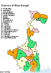
Districts of West Bengal
Encyclopedia
West Bengal
West Bengal is a state in the eastern region of India and is the nation's fourth-most populous. It is also the seventh-most populous sub-national entity in the world, with over 91 million inhabitants. A major agricultural producer, West Bengal is the sixth-largest contributor to India's GDP...
borders with Nepal, Bhutan, Bangladesh and the Indian states of Bihar
Bihar
Bihar is a state in eastern India. It is the 12th largest state in terms of geographical size at and 3rd largest by population. Almost 58% of Biharis are below the age of 25, which is the highest proportion in India....
, Jharkhand
Jharkhand
Jharkhand is a state in eastern India. It was carved out of the southern part of Bihar on 15 November 2000. Jharkhand shares its border with the states of Bihar to the north, Uttar Pradesh and Chhattisgarh to the west, Orissa to the south, and West Bengal to the east...
, Orissa
Orissa
Orissa , officially Odisha since Nov 2011, is a state of India, located on the east coast of India, by the Bay of Bengal. It is the modern name of the ancient nation of Kalinga, which was invaded by the Maurya Emperor Ashoka in 261 BC. The modern state of Orissa was established on 1 April...
, Assam
Assam
Assam , also, rarely, Assam Valley and formerly the Assam Province , is a northeastern state of India and is one of the most culturally and geographically distinct regions of the country...
and Sikkim
Sikkim
Sikkim is a landlocked Indian state nestled in the Himalayan mountains...
. The Himalayas
Himalayas
The Himalaya Range or Himalaya Mountains Sanskrit: Devanagari: हिमालय, literally "abode of snow"), usually called the Himalayas or Himalaya for short, is a mountain range in Asia, separating the Indian subcontinent from the Tibetan Plateau...
lies in the north of the state and the Bay of Bengal
Bay of Bengal
The Bay of Bengal , the largest bay in the world, forms the northeastern part of the Indian Ocean. It resembles a triangle in shape, and is bordered mostly by the Eastern Coast of India, southern coast of Bangladesh and Sri Lanka to the west and Burma and the Andaman and Nicobar Islands to the...
is at the south. In between them, the river Ganges flows eastwards and its main distributary
Distributary
A distributary, or a distributary channel, is a stream that branches off and flows away from a main stream channel. They are a common feature of river deltas. The phenomenon is known as river bifurcation. The opposite of a distributary is a tributary...
, the Hooghly River, flows south to reach the Bay of Bengal. The Siliguri Corridor, which connects North-East India
North-East India
Northeast India refers to the easternmost region of India consisting of the contiguous Seven Sister States, Sikkim, and parts of North Bengal...
with rest of the India, lies in the North Bengal
North Bengal
North Bengal is a term used for the northern parts of Bangladesh and West Bengal. The Bangladesh part denotes the Rajshahi Division. Generally it is the area lying west of Jamuna River and north of Padma River, and includes the Barind Tract. The West Bengal part denotes Cooch Behar, Darjeeling,...
region of the state. Geographically, West Bengal is divided into a variety of regions—Darjeeling Himalayan hill region
Darjeeling Himalayan hill region
Darjeeling Himalayan hill region or Darjeeling Himalaya is the mountainous area on the North-Western side of the state of West Bengal in India. This region belongs to the Eastern Himalaya range. The whole of the Darjeeling district except the Siliguri subdivision constitutes the region. It arises...
, Terai
Terai
The Terai is a belt of marshy grasslands, savannas, and forests located south of the outer foothills of the Himalaya, the Siwalik Hills, and north of the Indo-Gangetic Plain of the Ganges, Brahmaputra and their tributaries. The Terai belongs to the Terai-Duar savanna and grasslands ecoregion...
and Doors region, North Bengal plains
North Bengal plains
North Bengal plains starts from the south of Terai region and continues up to the left bank of the Ganges. The southern parts of the district Jalpaiguri, North Dinajpur baring some extreme northern regions, South Dinajpur, Malda and Cooch Behar districts constitute this geographical region....
, Rarh region
Rarh region
Rarh region of West Bengal is the region that lies between the Western plateau and high lands and the Ganges Delta...
, Western plateau and high lands
Western plateau and high lands
The Western plateau and highlands is the eastern border of the Chota Nagpur Plateau. It is historically called Vajjabhumi or Bajrabhumi. Bajra means hard. Probably it refers to the hard nature of the red laterite solid found here....
, coastal plains, Sunderbans and the Ganges Delta
Ganges Delta
The Ganges Delta is a river delta in the South Asia region of Bengal, consisting of Bangladesh and the state of West Bengal, India. It is the world's largest delta, and empties into the Bay of Bengal...
.
In 1947, when India gained independence, the state of West Bengal was formed with 14 districts, as per partition plan of the then Bengal
Bengal
Bengal is a historical and geographical region in the northeast region of the Indian Subcontinent at the apex of the Bay of Bengal. Today, it is mainly divided between the sovereign land of People's Republic of Bangladesh and the Indian state of West Bengal, although some regions of the previous...
province of British India. The former princely state Koch Bihar
Koch Bihar
Koch Bihar was a small kingdom located south of the Himalayan kingdom of Bhutan, west of the upper Brahmaputra valley Ahom kingdom, and north-east of the Ganges plain and Bengal. It was formed when the Kamata Kingdom under the Koch dynasty split following the death of Nara Narayan in 1586. The...
joined as a district in 1950, and the former French enclave Chandannagore joined as part of the Hooghly district
Hooghly District
Hooghly district is one of the districts of the state of West Bengal in India. It can alternatively be spelt Hoogli or Hugli. The district is named after the Hooghly River.The headquarters of the district are at Chinsura...
in 1954. The States Reorganisation Act
States Reorganisation Act
The States Reorganisation Act of 1956 was a major reform of the boundaries and governance of India's states and territories. The act reorganised the boundaries of India's states along linguistic lines, and amended the Indian Constitution to replace the three types of states, known as Parts A, B,...
of 1956 led to addition of Purulia district
Purulia District
Purulia district is one of the nineteen districts of West Bengal state in eastern India. The town of Purulia is the administrative headquarters of the district.-History:...
to the state and to enlargement of West Dinajpur district. Later, larger districts such as West Dinajpur, 24 Parganas and Midnapore were bifurcated.
West Bengal is now divided into nineteen districts under three divisions. Districts are administered by District Magistrates, and divisions are administered by Divisional Commissioners. Kolkata
Kolkata
Kolkata , formerly known as Calcutta, is the capital of the Indian state of West Bengal. Located on the east bank of the Hooghly River, it was the commercial capital of East India...
, the capital of the state, constitutes the Kolkata district
Kolkata District
Kolkata district is an administrative district of the Indian state of West Bengal. It contains the center part of the city of Kolkata. The jurisdiction of the Kolkata...
. Other districts are further divided into administrative units such as subdivisions and blocks, administered by SDO and BDO, respectively. The Panchayati Raj
Panchayati Raj
The panchayat raj is a South Asian political system mainly in India, Pakistan, and Nepal. "Panchayat" literally means assembly of five wise and respected elders chosen and accepted by the local community. Traditionally, these assemblies settled disputes between individuals and villages...
has a three-tier structure in the state. The atomic unit is called a Gram Panchayat
Gram panchayat
Gram panchayats are local self-governments at the village or small town level in India. As of 2002 there were about 265,000 gram panchayats in India. The gram panchayat is the foundation of the Panchayat System. A gram panchayat can be set up in villages with minimum population of 300...
, which is the Panchayat organization for a collection of villages. The block-level organizations are called Panchayat Samiti, and the district-level organizations are named Zilla Parishad.
Geography
West Bengal is bordered by three countries: Nepal, Bhutan and Bangladesh; and five Indian states: Sikkim, Bihar, Jharkhand, Chhattishgarh, Orissa, and Assam. Sikkim and Bhutan are located at the north of the state, Nepal at the northwest, Bihar, Jharkhand and Chhattishgarh at the west, Orissa at the southwest, the Bay of Bengal at the south, and Bangladesh and Assam are at the east. West Bengal is the only state of India that has both the Himalayas in the north and the Bay of Bengal at the south. In between them, the river Ganges enters the state from west, before it branches off into its main distributaries: the Hooghly River, which flows southwards to reach the Bay of Bengal, and the Padma RiverPadma River
The Padma is a major trans-boundary river in Bangladesh. It is the main distributary of the Ganges , which originates in the Himalayas. The Padma enters Bangladesh from India near Chapai Nababganj...
, which flows eastwards into Bangladesh.
The districts that are located at the north of the Ganges—Darjeeling
Darjeeling district
Darjeeling District is the northernmost district of the state of West Bengal in eastern India in the foothills of the Himalayas. The district is famous for its beautiful hill stations and Darjeeling tea. Darjeeling is the district headquarters...
, Jalpaiguri
Jalpaiguri District
Jalpaiguri district is the largest district of North Bengal, covering an area 6,245 km2. It is situated between 26° 16' and 27° 0' North latitudes and 88° 4' and 89° 53' East longitudes...
, Cooch Behar
Cooch Behar District
Cooch Behar district is a district of the state of West Bengal, India, as well as the district's namesake town. During the British Raj, the town of Cooch Behar was the seat of a princely state of Koch Bihar, ruled by the Koch dynasty....
, Malda
Malda district
Malda district is a district of West Bengal, India. It lies 347 km north of Kolkata, the state capital. Mango and silk are notable products of this district. The special variety of mango produced in this region, popularly known by the name of the district, is exported across the world and...
, North Dinajpur and South Dinajpur—are often referred to collectively as North Bengal. Geographically, this area is divided into the Darjeeling Himalayan hill region, the Terai and Doors region, and the North Bengal plains. The Siliguri Corridor, also known as Chicken's Neck, which connects North-East India with rest of the India, lies in this region. The Indo-Bangladesh enclaves
Indo-Bangladesh enclaves
The Indo-Bangladesh enclaves, also known as the chitmahals are the enclaves along the Bangladesh–India border, in Bangladesh and the Indian state of West Bengal....
are either enclaves or exclaves of the Cooch Behar district or the Jalpaiguri district.
The districts on the south of the Ganges—Bankura
Bankura District
Bankura district is one of the seven districts of Burdwan Division in the Indian state of West Bengal. The district has been described as the “connecting link between the plains of Bengal on the east and Chota Nagpur plateau on the west.” The areas to the east and north-east are low lying alluvial...
, Bardhaman
Bardhaman District
'Bardhaman district is a district in West Bengal. The headquarter of the district is Bardhaman, though it houses other important industrial towns like Durgapur and Asansol...
, Birbhum
Birbhum district
Birbhum district is an administrative unit in the Indian state of West Bengal. It is the northernmost district of Burdwan division—one of the three administrative divisions of West Bengal. The district headquarters is located at Suri...
, Purulia
Purulia District
Purulia district is one of the nineteen districts of West Bengal state in eastern India. The town of Purulia is the administrative headquarters of the district.-History:...
, Murshidabad
Murshidabad district
Murshidabad district is a district of West Bengal in eastern India. Situated on the left bank of the river Ganges, the district is very fertile. Covering an area of 5,341 km² and having a population 5.863m it is a densely populated district and the ninth most populous in India...
, Nadia
Nadia District
Nadia district is a district of the state of West Bengal, in the north east of India. It borders with Bangladesh to the east, North 24 Parganas and Hooghly districts to the south, Bardhaman district to the west, and Murshidabad district to the north....
, West Midnapore, East Midnapore, Hooghly
Hooghly District
Hooghly district is one of the districts of the state of West Bengal in India. It can alternatively be spelt Hoogli or Hugli. The district is named after the Hooghly River.The headquarters of the district are at Chinsura...
, Howrah
Howrah District
Howrah district is a district of the West Bengal state in eastern India. It has thousands of years of rich heritage in the form of the great Bengali kingdom of Bhurshut. The district is named after its headquarters, the city of Howrah.-Geography:...
, Kolkata
Kolkata District
Kolkata district is an administrative district of the Indian state of West Bengal. It contains the center part of the city of Kolkata. The jurisdiction of the Kolkata...
, North 24 Parganas
North 24 Parganas district
North 24 Parganas district is a district in southern West Bengal, of eastern India. North 24 Parganas extends in the [tropical zone] from latitude 22º11'6" north to 23º15'2" north and from longitude 88º20' east to 89º5' east...
and South 24 Parganas
South 24 Parganas district
South 24 Parganas district is an important district of West Bengal State with its district headquarters in Alipore. It has the urban fringe of Calcutta on one side and the remote riverine villages in the Sundarbans....
—constitute a variety of geographical regions such as the Rarh region, the Western plateau and high lands, the coastal plains, the Sunderbans and the Ganges Delta. Kolkata, the capital of the state, constitutes the Kolkata district.
The uninhabited South Talpatti Island
South Talpatti Island
New Moore or South Talpatti/Sheikh Mujib Island was a small uninhabited offshore sandbar landform in the Bay of Bengal, off the coast of the Ganges-Brahmaputra Delta region...
, which surfaced in the Bay of Bengal in 1970s near the Indo-Bangladesh border, is claimed by both India and Bangladesh.
History
After India gained independenceHistory of the Republic of India
The history of the Republic of India began on 26 January 1950. The country became an independent dominion within the British Commonwealth 15 August 1947. George VI was King until the Republic was proclaimed in 1950. Concurrently the Muslim-majority northwest and east of British India was separated...
in 1947, the province of Bengal was partitioned
Partition of Bengal (1947)
The Partition of Bengal in 1947, part of the Partition of India, was a religiously based partition that divided the British Indian province of Bengal between India and Pakistan...
along religious lines. The western part went to India (and was named West Bengal) while the eastern part joined Pakistan as a province called East Bengal
East Bengal
East Bengal was the name used during two periods in the 20th century for a territory that roughly corresponded to the modern state of Bangladesh. Both instances involved a violent partition of Bengal....
(later renamed East Pakistan
East Pakistan
East Pakistan was a provincial state of Pakistan established in 14 August 1947. The provincial state existed until its declaration of independence on 26 March 1971 as the independent nation of Bangladesh. Pakistan recognized the new nation on 16 December 1971. East Pakistan was created from Bengal...
, giving rise to Bangladesh in 1971). At the time of its creation in 1947, the state of West Bengal was divided into 14 districts—Bankura, Birbhum, Burdwan, Calcutta, Darjeeling, Jalpaiguri, Hooghly, Howrah, Malda, Midnapore, Murshidabad, Nadia, West Dinajpur and 24 Parganas. Cooch Behar district was a princely state
Princely state
A Princely State was a nominally sovereign entitity of British rule in India that was not directly governed by the British, but rather by an Indian ruler under a form of indirect rule such as suzerainty or paramountcy.-British relationship with the Princely States:India under the British Raj ...
named Koch Bihar till 20 August 1949, when the state formally agreed to join India. Transfer of administration was started on 12 September 1949 and was completed on 19 January 1950, when Cooch Behar became a district of West Bengal. Chandernagore, which was earlier part of the French India
French India
French India is a general name for the former French possessions in India These included Pondichéry , Karikal and Yanaon on the Coromandel Coast, Mahé on the Malabar Coast, and Chandannagar in Bengal...
, had voted to join India in a plebiscite in 1949. Formally, it joined India in 1952 and finally became a part of the Hooghly district of West Bengal on 2 October 1954. The States Reorganisation Act of 1956 reorganized boundaries of the Indian states along linguistic lines. As this act was implemented, the then West Dinajpur district was enlarged with the addition of some areas from Bihar, and the Purulia district was formed on 1 November 1956 from parts of the Manbhum district of Bihar.
Later, some large districts were divided into smaller districts. On 1 March 1986, the district of 24 Parganas
24 Parganas
24 Parganas district is a former district of the Indian state of West Bengal. The district was split into two districts — North 24 Parganas district and South 24 Parganas district, with effect from 1 March 1986....
was bifurcated into two districts—the North 24 Parganas district and the South 24 Parganas district. On 1 April 1992, the West Dinajpur district
West Dinajpur district
West Dinajpur district was a district of the state of West Bengal from 1947 to 1992. At India's independence, the former Dinajpur district of undivided Bengal was partitioned along religious lines, and West Dinajpur became one of the 14 districts of West Bengal...
was bifurcated into the North Dinajpur district and the South Dinajpur district. On 1 January 2002, the erstwhile Midnapore district
Midnapore District
Midnapore district is a former district of the state of West Bengal, India. This district was bifurcated on January 1, 2002 into the Purba Medinipur district and the Paschim Medinipur district.-References:...
was bifurcated into the Purba Medinipur district and the Paschim Medinipur district.
Since 2007, the demand for a separate Gorkhaland
Gorkhaland
Gorkhaland is the name of the proposed state in India demanded by the Nepali/Gorkhali-speaking Nepali/Gorkha ethnic group in Darjeeling and the Dooars in north West Bengal....
state has been revived by the Gorkha Janmukti Morcha
Gorkha Janmukti Morcha
Gorkha Janmukti Morcha is a registered political party which campaigns for the creation of a separate state within India, out of districts in the north of West Bengal...
and its supporters in the Darjeeling hills. The Kamtapur People's Party and its supporters' movement for a separate Kamtapur
Kamtapur
Kamtapur is the name of a state proposed in north West Bengal and Assam by the Rajbongshi people. The proposed state comprises some districts of West Bengal and other contiguous districts of Assam. This statehood demand is mostly led by Kamtapur People's Party....
state that covers the North Bengal has also gained momentum in 2000s.
Administrative structure
District collector
The District Collector is the district head of administration of the bureaucracy in a state of India. Though he/she is appointed and is under general supervision of the state government, he/she has to be a member of the elite IAS recruited by the Central Government...
, who is better known as a District Magistrate (DM) in the state of West Bengal. A DM is an officer from either Indian Administrative Service
Indian Administrative Service
The Indian Administrative Service is the administrative civil service of the Government of India. It is one of the three All India Services....
(IAS) or West Bengal Civil Service
West Bengal Civil Service
The recruitment to this Service is made on the basis of annual Examination called "W.B.C.S. etc. Examination", conducted by Public Service Commission,West Bengal which is a three-stage competitive selection process consisting of a preliminary exam, a main exam, and an interview...
(WBCS), and is appointed by the State Government of West Bengal. Each district is divided into subdivisions, except the Kolkata district, which contains urban area only, administered by Kolkata Municipal Corporation
Kolkata Municipal Corporation
Kolkata Municipal Corporation is responsible for the civic infrastructure and administration of the city of Kolkata. The organization is known, in short, as KMC . This civic administrative body administers an area of 185 sq. km. Its motto, Purosree Bibardhan, is inscribed on its emblem in Bengali...
. A subdivision is governed by a sub-divisional magistrate
Sub-Divisional Magistrate
A Sub-Divisional Magistrate is a title sometimes given to the head official of a country subdivision, an administrative unit that is sometimes below the level of district, depending on a country's government structure....
(SDM), better known as a Sub-Divisional Officer (SDO). Other than urban units such as town municipalities
Municipality
A municipality is essentially an urban administrative division having corporate status and usually powers of self-government. It can also be used to mean the governing body of a municipality. A municipality is a general-purpose administrative subdivision, as opposed to a special-purpose district...
, a subdivision contains 'community development blocks' (also known as CD blocks or blocks). A block consists of urban units such as census town
Census town
In India, a census town is one which has:# A minimum population of 5,000# At least 75% of male working population engaged in non-agricultural pursuits# A density of population of at least 400 persons per km2.In Ireland, a census town is;...
s and rural units called gram panchayat
Gram panchayat
Gram panchayats are local self-governments at the village or small town level in India. As of 2002 there were about 265,000 gram panchayats in India. The gram panchayat is the foundation of the Panchayat System. A gram panchayat can be set up in villages with minimum population of 300...
s. A block is administered by a Block Development Officer (BDO), who is appointed by the Government of West Bengal.
A gram panchayat, which consists of a group of villages, is administered by a village council headed by a Pradhan
Sarpanch
A sarpanch is a democratically elected head of a village level statutory institution of local self-government called the gram panchayat in India and Pakistan. He, together with other elected Panchas , constitute the Gram Panchayat. The Sarpanch is the focal point of contact between government...
. As per the West Bengal Panchayat Act, 1973, each Block has a Panchayat Samiti, whose members include the Pradhans of the constituent gram panchayats, and the MLA
Member of Legislative Assembly
A Member of Legislative Assembly, or MLA, is a representative elected by the voters of an electoral district to the Legislature of a State in the Indian system of government...
s from the block. A Panchayat Samiti is headed by a Sabhadhipati. The third tier of the Panchayati Raj is Zilla Parishad, a district level organization with the Sabhapatis of the constituent Panchayat Samitis and the MLA
Member of Legislative Assembly
A Member of Legislative Assembly, or MLA, is a representative elected by the voters of an electoral district to the Legislature of a State in the Indian system of government...
s from the district as its members. A Zilla Parishad is headed by a Sabhadhipati. For the Darjeeling district, the Zilla Parishad has ceased to exist, but a similar organization for the Siliguri subdivision
Siliguri subdivision
Siliguri subdivision is a subdivision of the Darjeeling district in the state of West Bengal, India. It consists of the Siliguri municipal corporation and four community development blocks: Matigara, Naxalbari, Phansidewa and Kharibari. The four blocks contain 22 gram panchayats and two census...
exists, which is designated as a Mahakuma Parishad.
The Gorkha Hill Council, formed in 1988, administers three (out of four) subdivisions of the Darjeeling district: Darjeeling Sadar, Kalimpong
Kalimpong subdivision
Kalimpong subdivision is a subdivision of the Darjeeling district in the state of West Bengal, India. It consists of the Kalimpong municipality and three community development blocks: Kalimpong–I, Kalimpong–II and Gorubathan. The three blocks contain 42 gram panchayats...
and Kurseong
Kurseong subdivision
Kurseong subdivision is a subdivision of the Darjeeling district in the state of West Bengal, India. It consists of the Kurseong municipality, Mirik municipality and two community development blocks: Mirik and Kurseong. The two blocks contain 20 gram panchayats...
. Gorkha Hill Council manages the departments of Public Health, Education, Public Works, Transport, Tourism, Market, Small scale industries, Agriculture, Agricultural waterways, Forest (except reserved forests), Water, Livestock, Vocational Training and Sports and Youth services. District administration of Darjeeling, which is still responsible for election, panchayat, law and order, revenue etc., also acts as an interface between the Council and the State Government.
A District Superintendent of Police, better known as a Superintendent of Police, heads the District Police organization of West Bengal Police
West Bengal Police
The West Bengal Police is one of the two police forces of the Indian state of West Bengal....
. This is as per the Police Act of 1861, which is applicable to the whole of India. The Superintendents of Police are officers of the Indian Police Service
Indian Police Service
The Indian Police Service , simply known as Indian Police or IPS, is one of the three All India Services of the Government of India...
. For every subdivision, there is a Subdivision Police, headed by a Police officer of the rank of Assistant Superintendent of Police or Deputy Superintendent of Police. Under subdivisions, there are Police Circles, each headed by an Inspector of Police. A Police Circle consists of Police Stations, each headed by an Inspector of Police, or in case of rural areas, by a Sub-Inspector of Police.
The Calcutta High Court
Calcutta High Court
The Calcutta High Court is the oldest High Court in India. It was established as the High Court of Judicature at Fort William on 1 July 1862 under the High Courts Act, 1861. It has jurisdiction over the state of West Bengal and the Union Territory of the Andaman and Nicobar Islands. The High Court...
has the jurisdiction of the state of West Bengal. Though most of the districts have more courts other than a District Court, not every subdivision of the state has a Court.
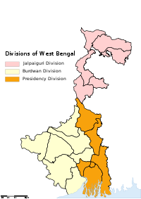
A group of districts forms a division, which is administered by a 'Divisional Commissioner'. West Bengal is now divided in nineteen districts, grouped under three divisions:
| Jalpaiguri division Jalpaiguri division Jalpaiguri Division is a division in the Indian state of West Bengal. It consists of 6 districts:* Jalpaiguri district* Darjeeling district* Cooch Behar district* Malda district* North Dinajpur district... |
Burdwan division Burdwan Division Burdwan Division is a division in the Indian state of West Bengal. It consists of 7 districts:* Bankura district* Bardhaman district* Birbhum district* East Midnapore * Hooghly district* Purulia district... |
Presidency division Presidency division Presidency Division is a division in the Indian state of West Bengal. It consists of 6 districts:* Howrah district* Kolkata district* Murshidabad district* Nadia district* North 24 Parganas district* South 24 Parganas district-References:... |
|---|---|---|
|
|
|
Alphabetical listing
| Code | District | Headquarters | Established | Subdivisions | Area | Population Density Population density Population density is a measurement of population per unit area or unit volume. It is frequently applied to living organisms, and particularly to humans... |
Map | |
|---|---|---|---|---|---|---|---|---|
| BN | Bankura Bankura District Bankura district is one of the seven districts of Burdwan Division in the Indian state of West Bengal. The district has been described as the “connecting link between the plains of Bengal on the east and Chota Nagpur plateau on the west.” The areas to the east and north-east are low lying alluvial... |
Bankura Bankura Bankura is a city and a municipality in Bankura District in the state of West Bengal, India. It is the headquarters of the Bankura District.-Etymology:... |
1947 |
|
6882 km² (2,657.2 sq mi) | 3,192,695 | 464 /km2 | 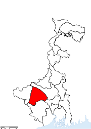 |
| BR | Bardhaman Bardhaman District 'Bardhaman district is a district in West Bengal. The headquarter of the district is Bardhaman, though it houses other important industrial towns like Durgapur and Asansol... |
Bardhaman Bardhaman 'Bardhaman or Burdwan , is a city of West Bengal state in eastern India. It is the headquarters of Bardhaman District.... |
1947 |
Asansol subdivision Asansol subdivision is a subdivision of the Bardhaman district in the state of West Bengal, India. It consists of Asansol municipal corporation, three municipalities and four community development blocs: Barabani, Jamuria, Raniganj and Salanpur. The four blocks contain 35 gram panchayats and 18... Durgapur subdivision Durgapur subdivision is a subdivision of the Bardhaman district in the state of West Bengal, India. It consists of Durgapur municipal corporation and five community development blocs: Durgapur–Faridpur, Galsi–I, Kanksa, Andal and Pandabeswar. The five blocks contain 36 gram panchayats... Kalna subdivision Kalna subdivision is a subdivision of the Bardhaman district in the state of West Bengal, India. It consists of Kalna municipality and five community development blocks: Kalna–I, Kalna–II, Manteswar, Purbasthali–I and Purbasthali–II. The five blocks contain 47 gram... Katwa subdivision Katwa subdivision is a subdivision of the Bardhaman district in the state of West Bengal, India. It consists of Katwa municipality, Dainhat municipality and five community development blocks: Katwa–I, Katwa–II, Ketugram–I, Ketugram–II and Mongolkote. The five blocks contain... Bardhaman Sadar North subdivision Bardhaman Sadar North subdivision is a subdivision of the Bardhaman district in the state of West Bengal, India. It consists of Bardhaman municipality, Guskara municipality and six community development blocks: Ausgram — I, Ausgram–II, Bhatar, Burdwan–I, Burdwan–II and... Bardhaman Sadar South subdivision Bardhaman Sadar South subdivision is a subdivision of the Bardhaman district in the state of West Bengal, India. It consists of Memari municipality and six community development blocks: Khandaghosh, Jamalpur, Memari–I, Memari –II, Raina–I and Raina–II. The six blocks... |
7024 km² (2,712 sq mi) | 6,895,514 | 982 /km2 | 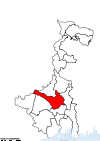 |
| BI | Birbhum Birbhum district Birbhum district is an administrative unit in the Indian state of West Bengal. It is the northernmost district of Burdwan division—one of the three administrative divisions of West Bengal. The district headquarters is located at Suri... |
Suri | 1947 |
Suri Sadar subdivision Suri Sadar subdivision is a subdivision of the Birbhum district in the state of West Bengal, India. It consists of three municipalities and seven community development blocs: Suri — I, Suri — II, Saithiya, Dubrajpur, Khayrashol, Rajnagar and Mahammad Bazar. The seven blocks contain one... Bolpur subdivision Bolpur subdivision is a subdivision of the Birbhum district in the state of West Bengal, India. It consists of Bolpur municipality and four community development blocs: Bolpur–Sriniketan, Ilambazar, Labhpur and Nanoor. The four blocks contain 40 gram panchayats... Rampurhat subdivision Rampurhat subdivision is a subdivision of the Birbhum district in the state of West Bengal, India. It consists of Rampurhat municipality, Nalhati municipality and eight community development blocks: Mayureswar–I, Mayureswar–II, Rampurhat–I, Rampurhat–II, Murarai–I,... |
4545 km² (1,754.8 sq mi) | 3,015,422 | 663 /km2 | 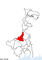 |
| KB | Cooch Behar Cooch Behar District Cooch Behar district is a district of the state of West Bengal, India, as well as the district's namesake town. During the British Raj, the town of Cooch Behar was the seat of a princely state of Koch Bihar, ruled by the Koch dynasty.... |
Cooch Behar Cooch Behar Cooch Behar is the district headquarters and the largest city of Cooch Behar District in the Indian state of West Bengal. It is situated in the foothills of the Eastern Himalayas and located at . Cooch Behar is the only planned town in North Bengal region with remnants of royal heritage... |
1950 |
Cooch Behar Sadar subdivision Cooch Behar Sadar subdivision is a subdivision of the Cooch Behar district in the state of West Bengal, India. It consists of Cooch Behar municipality and two community development blocs: Cooch Behar–I and Cooch Behar–II. The two blocks contain 28 gram panchayats and three census towns... Dinhata subdivision Dinhata subdivision is a subdivision of the Cooch Behar district in the state of West Bengal, India. It consists of Dinhata municipality and three community development blocks: Dinhata–I, Dinhata–II and Sitai. The three blocks contain 33 gram panchayats and one census town... Mathabhanga subdivision Mathabhanga subdivision is a subdivision of the Cooch Behar district in the state of West Bengal, India. It consists of Mathabhanga municipality and three community development blocks: Sitalkuchi, Mathabhanga–I and Mathabhanga–II. The three blocks contain 28 gram panchayats... Mekhliganj subdivision Mekhliganj subdivision is a subdivision of the Cooch Behar district in the state of West Bengal, India. It consists of Mekhliganj municipality, Haldibari municipality, and two community development blocks: Mekhliganj and Haldibari. The two blocks contain 14 gram panchayats... Tufanganj subdivision Tufanganj subdivision is a subdivision of the Cooch Behar district in the state of West Bengal, India. It consists of Tufanganj municipality and two community development blocks: Tufanganj–I and Tufanganj–II. The two blocks contain 25 gram panchayats... |
3387 km² (1,307.7 sq mi) | 2,479,155 | 732 /km2 | 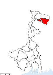 |
| DA | Darjeeling Darjeeling district Darjeeling District is the northernmost district of the state of West Bengal in eastern India in the foothills of the Himalayas. The district is famous for its beautiful hill stations and Darjeeling tea. Darjeeling is the district headquarters... |
Darjeeling | 1947 |
Kalimpong subdivision Kalimpong subdivision is a subdivision of the Darjeeling district in the state of West Bengal, India. It consists of the Kalimpong municipality and three community development blocks: Kalimpong–I, Kalimpong–II and Gorubathan. The three blocks contain 42 gram panchayats... Kurseong subdivision Kurseong subdivision is a subdivision of the Darjeeling district in the state of West Bengal, India. It consists of the Kurseong municipality, Mirik municipality and two community development blocks: Mirik and Kurseong. The two blocks contain 20 gram panchayats... Siliguri subdivision Siliguri subdivision is a subdivision of the Darjeeling district in the state of West Bengal, India. It consists of the Siliguri municipal corporation and four community development blocks: Matigara, Naxalbari, Phansidewa and Kharibari. The four blocks contain 22 gram panchayats and two census... |
3149 km² (1,215.8 sq mi) | 1,609,172 | 511 /km2 | 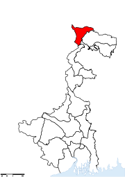 |
| ME | East Midnapore | Tamluk Tamluk Tamluk is the district headquarters of Purba Medinipur district of West Bengal, India. Though there is some controversy, scholars have generally agreed that present day Tamluk is the site of the ancient city variously known as Tamralipta or Tamralipti... |
2002 |
Tamluk subdivision Tamluk subdivision , is a subdivision of the Purba Medinipur district in the state of West Bengal, India. It consists of Tamluk municipality, Panskura municipality and seven community development blocks: Nandakumar, Mayna, Tamluk, Shahid Matangini, Panskura–I, Panskura–II and Chandipur... Haldia subdivision Haldia subdivision , is a subdivision of the Purba Medinipur district in the state of West Bengal, India. It consists of Haldia municipality and five community development blocks: Mahisadal, Nandigram–I, Nandigram–II, Sutahata and Haldia. The five blocks contain 38 gram panchayats... Egra subdivision Egra subdivision , is a subdivision of the Purba Medinipur district in the state of West Bengal, India. It consists of Egra municipality and six community development blocks: Bhagawanpur–I, Bhagawanpur–II, Egra–I, Egra–II, Pataspur–I and Pataspur–II. The six... Contai subdivision Contai subdivision , is a subdivision of the Purba Medinipur district in the state of West Bengal, India. It consists of Contai municipality and eight community development blocks: Kanthi–I, Kanthi–II, Kanthi–III, Khejuri–I, Khejuri–II, Ramnagar–I and... |
4785 km² (1,847.5 sq mi) | 4,417,377 | 923 /km2 | 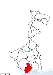 |
| HG | Hooghly Hooghly District Hooghly district is one of the districts of the state of West Bengal in India. It can alternatively be spelt Hoogli or Hugli. The district is named after the Hooghly River.The headquarters of the district are at Chinsura... |
Chinsura | 1947 |
Chinsurah subdivision Chinsurah subdivision , is a subdivision of the Hooghly district in the state of West Bengal, India. It consists of two municipalities and five community development blocs: Balagarh, Chinsurah–Mogra, Dhaniakhali, Pandua and Polba–Dadpur. The five blocks contain 69 gram panchayats and... Chandannagore subdivision Chandannagore subdivision , is a subdivision of the Hooghly district in the state of West Bengal, India. It consists of Chandannagar municipal corporation and three municipalities and three community development blocs: Haripal, Singur and Tarakeswar. The three blocks contain 41 gram panchayats and... Srirampore subdivision Srirampore subdivision , is a subdivision of the Hooghly district in the state of West Bengal, India. It consists of five municipalities and four community development blocks: Chanditala–I, Chanditala–II, Jangipara and Sreerampur Uttarpara. The four blocks contain 37 gram panchayats... |
3149 km² (1,215.8 sq mi) | 5,041,976 | 1601 /km2 |  |
| HR | Howrah Howrah District Howrah district is a district of the West Bengal state in eastern India. It has thousands of years of rich heritage in the form of the great Bengali kingdom of Bhurshut. The district is named after its headquarters, the city of Howrah.-Geography:... |
Howrah | 1947 |
Howrah Sadar subdivision Howrah Sadar subdivision , is a subdivision of the Howrah district in the state of West Bengal, India. It consists of Howrah municipal corporation and Bally municipality and five community development blocs: Bally Jagacha, Domjur, Panchla, Sankrail and Jagatballavpur. The five blocks contain 67... Uluberia subdivision Uluberia subdivision , is a subdivision of the Howrah district in the state of West Bengal, India. It consists of Uluberia municipality and nine CD blocks: Uluberia–I, Uluberia–II, Amta–I, Amta–II, Udaynarayanpur, Bagnan–I, Bagnan–II, Shyampur–I and... |
1467 km² (566.4 sq mi) | 4,273,099 | 2913 /km2 |  |
| JA | Jalpaiguri Jalpaiguri District Jalpaiguri district is the largest district of North Bengal, covering an area 6,245 km2. It is situated between 26° 16' and 27° 0' North latitudes and 88° 4' and 89° 53' East longitudes... |
Jalpaiguri Jalpaiguri Jalpaiguri is a city in the state of West Bengal, India. It is the headquarters of Jalpaiguri district, and the divisional headquarters of the North Bengal region.-History:... |
1947 |
Jalpaiguri Sadar subdivision Jalpaiguri Sadar subdivision , is a subdivision of the Jalpaiguri district in the state of West Bengal, India. It consists of Jalpaiguri and Dhupguri municipalities and four community development blocks: Jalpaiguri, Mainaguri, Dhupguri and Rajganj. The four blocks contain 62 gram panchayats and... Malbazar subdivision Malbazar subdivision , also known as Mal subdivision, is a subdivision of the Jalpaiguri district in the state of West Bengal, India. It consists of Malbazar municipality and three community development blocks: Mal, Metiali and Nagrakata. The three blocks contain 22 gram panchayats. The subdivision... Alipurduar subdivision Alipurduar subdivision , is a subdivision of the Jalpaiguri district in the state of West Bengal, India. It consists of Alipurduar municipality and six community development blocks: Madarihat–Birpara, Alipurduar–I, Alipurduar–II, Falakata, Kalchini and Kumargram. The six blocks... |
6227 km² (2,404.3 sq mi) | 3,401,173 | 546 /km2 | 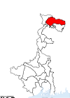 |
| KO | Kolkata Kolkata District Kolkata district is an administrative district of the Indian state of West Bengal. It contains the center part of the city of Kolkata. The jurisdiction of the Kolkata... |
Kolkata Kolkata Kolkata , formerly known as Calcutta, is the capital of the Indian state of West Bengal. Located on the east bank of the Hooghly River, it was the commercial capital of East India... |
1947 | — | 185 km² (71.4 sq mi) | 4,572,876 | 24718 /km2 | 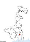 |
| MA | Malda Malda district Malda district is a district of West Bengal, India. It lies 347 km north of Kolkata, the state capital. Mango and silk are notable products of this district. The special variety of mango produced in this region, popularly known by the name of the district, is exported across the world and... |
English Bazar English Bazar English Bazar, better known as Malda, called mango city, is a city and a municipality in Malda district in the state of West Bengal, India. Malda is the fifth largest city in West Bengal. Malda is nominated for becoming the municipal corporation... |
1947 |
Chanchal subdivision Chanchal subdivision is a subdivision of the Malda district in the state of West Bengal, India. It consists of six community development blocks: Chanchal–I, Chanchal–II, Ratua–I, Ratua–II, Harishchandrapur–I and Harishchandrapur–II. The six blocks contain 49... Malda Sadar subdivision Malda Sadar subdivision is a subdivision of the Malda district in the state of West Bengal, India. It consists of Old Maldah municipality, English Bazar municipality and nine community development blocks: English Bazar, Gazole, Habibpur, Kaliachak–I, Kaliachak–II, Kaliachak–III,... |
3733 km² (1,441.3 sq mi) | 3,290,468 | 881 /km2 | 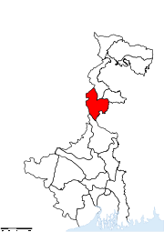 |
| MU | Murshidabad Murshidabad district Murshidabad district is a district of West Bengal in eastern India. Situated on the left bank of the river Ganges, the district is very fertile. Covering an area of 5,341 km² and having a population 5.863m it is a densely populated district and the ninth most populous in India... |
Baharampur Baharampur Baharampur is a city in the West Bengal state of India. Baharampur is the sixth largest city in West Bengal and situated in central part of West Bengal. Baharampur is nominated for becoming the municipal corporation... |
1947 |
Barhampur subdivision Barhampur subdivision , is a subdivision of the Murshidabad district in the state of West Bengal, India. It consists of Baharampur municipality, Beldanga municipality, and five community development blocks: Berhampore, Beldanga–I, Beldanga–II, Hariharpara and Naoda. The five blocks... Domkol subdivision Domkol subdivision , is a subdivision of the Murshidabad district in the state of West Bengal, India. It consists of Dhulian municipality and four community development blocks: Domkol, Raninagar–I, Raninagar–II and Jalangi. The four blocks contain 38 gram panchayats and one census town... Lalbag subdivision Lalbag subdivision , is a subdivision of the Murshidabad district in the state of West Bengal, India. It consists of Murshidabad municipality, Jiaganj Azimganj municipality and five community development blocks: Murshidabad–Jiaganj, Bhagawangola–I, Bhagawangola–II, Lalgola and... Kandi subdivision Kandi subdivision , is a subdivision of the Murshidabad district in the state of West Bengal, India. It consists of Kandi municipality and five community development blocks: Kandi, Khargram, Burwan, Bharatpur–I and Bharatpur–II. The five blocks contain 50 gram panchayats... Jangipur subdivision Jangipur subdivision , is a subdivision of the Murshidabad district in the state of West Bengal, India. It consists of Jangipur municipality and seven community development blocks: Raghnathganj–I, Raghnathganj–II, Suti–I, Suti–II, Samserganj, Sagardighi and Farakka. The... |
5324 km² (2,055.6 sq mi) | 5,866,569 | 1102 /km2 | 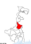 |
| NA | Nadia Nadia District Nadia district is a district of the state of West Bengal, in the north east of India. It borders with Bangladesh to the east, North 24 Parganas and Hooghly districts to the south, Bardhaman district to the west, and Murshidabad district to the north.... |
Krishnanagar | 1947 |
Krishnanagar Sadar subdivision Krishnanagar Sadar subdivision , is a subdivision of the Nadia district in the state of West Bengal, India. It consists of Krishnanagar municipality, Nabadwip municipality and seven community development blocks: Kaliganj, Nakashipara, Chapra, Krishnanagar–I, Krishnanagar–II, Nabadwip... Kalyani subdivision Kalyani subdivision , is a subdivision of the Nadia district in the state of West Bengal, India. It consists of Chakdaha municipality, Gayespur municipality, Kalyani municipality and two community development blocks: Chakdaha and Haringhata. The two blocks contain 27 gram panchayats and two census... Ranaghat subdivision Ranaghat subdivision , is a subdivision of the Nadia district in the state of West Bengal, India. It consists of Shantipur municipality, Ranaghat municipality, Birnagar municipality and four community development blocks: Hanskhali, Shantipur, Ranaghat–I and Ranaghat–II. The four blocks... Tehatta subdivision Tehatta subdivision , is a subdivision of the Nadia district in the state of West Bengal, India. It consists of four community development blocks: Karimpur–I, Karimpur–II, Tehatta–I and Tehatta–II. The four blocks contain 36 gram panchayats and one census town... |
3927 km² (1,516.2 sq mi) | 4,604,827 | 1173 /km2 | 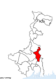 |
| PN | North 24 Parganas North 24 Parganas district North 24 Parganas district is a district in southern West Bengal, of eastern India. North 24 Parganas extends in the [tropical zone] from latitude 22º11'6" north to 23º15'2" north and from longitude 88º20' east to 89º5' east... |
Barasat Barasat Barasat is a city in the outskirts of Kolkata, West Bengal India and is the district head quarter of the district North 24 Parganas. It is a part of the area covered by Kolkata Metropolitan Development Authority. The town is an important railway and roadway junction... |
1986 |
Barrackpore subdivision Barrackpore subdivision , is a subdivision of the North 24 Parganas district in the state of West Bengal, India. It consists of sixteen municipalities , one Cantonment Board ,... Barasat Sadar subdivision Barasat Sadar subdivision , is a subdivision of the North 24 Parganas district in the state of West Bengal, India. It consists of six municipalities and seven community development blocks: Barasat–I, Barasat–II, Amdanga, Deganga, Habra–I, Habra–II and Rajarhat... Bangaon subdivision Bangaon subdivision , is a subdivision of the North 24 Parganas district in the state of West Bengal, India. It consists of Bangaon municipality and three community development blocks: Bagda, Bangaon and Gaighata. The three blocks contain two census towns and 38 gram panchayats... Basirhat subdivision Basirhat subdivision , is a subdivision of the North 24 Parganas district in the state of West Bengal, India. It consists of three municipalities and ten community development blocks: Baduria, Basirhat–I, Basirhat–II, Haroa, Hasnabad, Hingalganj, Minakhan, Sandeshkhali–I and... Bidhannagar subdivision Bidhannagar subdivision , is a subdivision of the North 24 Parganas district in the state of West Bengal, India. It consists of only Bidhannagar municipality. The subdivision has its headquarters at Bidhannagar.-Area:... |
4094 km² (1,580.7 sq mi) | 8,934,286 | 2182 /km2 |  |
| UD | North Dinajpur | Raiganj Raiganj Raiganj is a city and a municipality in Uttar Dinajpur district in the Indian state of West Bengal. It is the headquarters of a district as well as a subdivision.-Geography:... |
1992 |
Raiganj subdivision Raiganj subdivision is a subdivision of the North Dinajpur district in the state of West Bengal, India. It consists of Raiganj municipality, Kaliaganj municipality and four community development blocs: Hemtabad, Itahar, Kaliganj and Raiganj. The four blocks contain 39 gram panchayats and two... Islampur subdivision Islampur subdivision is a subdivision of the North Dinajpur district in the state of West Bengal, India. It consists of Islampur municipality, Dalkhola municipality and five community development blocs: Chopra, Goalpokhar–I, Goalpokhar–II, Islampur and Karandighi. The five blocks... |
3140 km² (1,212.4 sq mi) | 2,441,794 | 778 /km2 |  |
| PU | Purulia Purulia District Purulia district is one of the nineteen districts of West Bengal state in eastern India. The town of Purulia is the administrative headquarters of the district.-History:... |
Purulia Purulia Purulia , also spelled Puruliya, also known as "Manbhum City", is a city located in West Bengal state, India, and was constituted in 1876. It is the location of the district headquarters of Purulia district. Purulia is located on the north of the Kasai river and is a major road and railway... |
1956 |
Purulia Sadar East subdivision Purulia Sadar East subdivision is a subdivision of the Purulia district in the state of West Bengal, India. It consists of Purulia municipality and seven community development blocks: Manbazar–I, Manbazar–II, Bundwan, Purulia–I, Purulia–II, Hura and Puncha. The seven blocks... Purulia Sadar West subdivision Purulia Sadar West subdivision is a subdivision of the Purulia district in the state of West Bengal, India. It consists of Jhalda municipality and seven community development blocks: Jhalda–I, Jhalda–II, Jaipur, Arsha, Bagmundi, Balarampur and Barabazar. The seven blocks contain 59... Raghunathpur subdivision Raghunathpur subdivision is a subdivision of the Purulia district in the state of West Bengal, India. It consists of Raghunathpur municipality and six community development blocks: Para, Raghunathpur–I, Raghunathpur–II, Neturia, Santuri and Kashipur. The six blocks contain 49 gram... |
6259 km² (2,416.6 sq mi) | 2,536,516 | 405 /km2 | 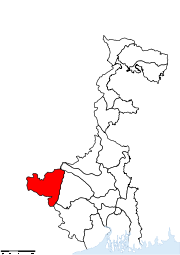 |
| PS | South 24 Parganas South 24 Parganas district South 24 Parganas district is an important district of West Bengal State with its district headquarters in Alipore. It has the urban fringe of Calcutta on one side and the remote riverine villages in the Sundarbans.... |
Alipore Alipore Alipore is headquarters of South 24 Parganas district and a neighbourhood in South Kolkata in the Indian state of West Bengal.Alipore, Kolkata, not to be confused with Alipore, Gujarat, is one of the poshest and costliest localities in Kolkata, along with the area Ballygunge... |
1986 |
Baruipur subdivision Baruipur subdivision , is a subdivision of the South 24 Parganas district in the state of West Bengal, India. It consists of three municipalities and seven community development blocks: Baruipur, Bhangar–I, Bhangar–II, Jaynagar–I, Jaynagar–II, Kultali and Sonarpur... Canning subdivision Canning subdivision , is a subdivision of the South 24 Parganas district in the state of West Bengal, India. It consists of four community development blocks: Basanti, Canning–I, Canning–II and Gosaba. The four blocks contain 46 gram panchayats... Diamond Harbour subdivision Diamond Harbour subdivision , is a subdivision of the South 24 Parganas district in the state of West Bengal, India. It consists of Diamond Harbour municipality and nine community development blocks: Diamond Harbour–I, Diamond Harbour–II, Falta, Kulpi, Magrahat–I,... Kakdwip subdivision Kakdwip subdivision , is a subdivision of the South 24 Parganas district in the state of West Bengal, India. It consists of four community development blocks: Kakdwip, Namkhana, Patharpratima and Sagar. The four blocks contain 42 gram panchayats... Alipore Sadar subdivision Alipore Sadar subdivision , is a subdivision of the South 24 Parganas district in the state of West Bengal, India. It consists of three municipalities and five community development blocks: Bishnupur–I, Bishnupur–II, Budge Budge–I, Budge Budge–II and Thakurpukur Maheshtala... |
9960 km² (3,845.6 sq mi) | 6,906,689 | 693 /km2 |  |
| DD | South Dinajpur | Balurghat Balurghat Balurghat is the headquarters of the Dakshin Dinajpur district of West Bengal in India. Hili Balurghat is the headquarters of the Dakshin Dinajpur district of West Bengal in India. Hili Balurghat is the headquarters of the Dakshin Dinajpur district of West Bengal in India. Hili (Bangladesh... |
1992 |
Balurghat subdivision Balurghat subdivision is a subdivision of the South Dinajpur district in the state of West Bengal, India. It consists of Balurghat municipality and four community development blocs: Hili, Balurghat, Kumarganj and Tapan. The four blocks contain 35 gram panchayats... Gangarampur subdivision Gangarampur subdivision is a subdivision of the South Dinajpur district in the state of West Bengal, India. It consists of Gangarampur municipality and four community development blocs: Gangarampur, Bangsihari, Harirampur and Kushmandi. The four blocks contain 30 gram panchayats... |
2219 km² (856.8 sq mi) | 1,503,178 | 677 /km2 | 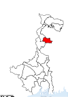 |
| ME | West Midnapore | Medinipur | 2002 |
Kharagpur subdivision Kharagpur subdivision , is a subdivision of the Paschim Medinipur district in the state of West Bengal, India. It consists of Kharagpur municipality and ten community development blocks: Dantan–I, Dantan–II, Pingla, Kharagpur–I, Kharagpur–II, Sabang, Mohanpur, Narayangarh,... Medinipur Sadar subdivision Medinipur Sadar subdivision , is a subdivision of the Paschim Medinipur district in the state of West Bengal, India. It consists of Midnapore municipality and six community development blocks: Medinipur Sadar, Garhbeta–I, Garhbeta–II, Garhbeta–III, Keshpur and Shalboni. The six... Ghatal subdivision Ghatal subdivision , is a subdivision of the Paschim Medinipur district in the state of West Bengal, India. It consists of five municipalities and five community development blocks: Chandrakona–I, Chandrakona–II, Daspur–I, Daspur–II and Ghatal. The five blocks contain 48... Jhargram subdivision Jhargram subdivision , is a subdivision of the Paschim Medinipur district in the state of West Bengal, India. It consists of Jhargram municipality and eight community development blocks: Binpur–I, Binpur–II, Jamboni, Jhargram, Gopiballavpur–I, Gopiballavpur–II, Nayagram and... |
9296 km² (3,589.2 sq mi) | 5,193,411 | 559 /km2 | 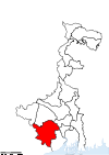 |
| Total | — | — | — | 66 | 80,176,197 | — |
See also
- List of RTO districts in West Bengal